This is a list of the National Register of Historic Places listings in Nicollet County, Minnesota. It is intended to be a complete list of the properties and districts on the National Register of Historic Places in Nicollet County, Minnesota, United States. The locations of National Register properties and districts for which the latitude and longitude coordinates are included below, may be seen in an online map.

This is a list of the National Register of Historic Places listings in Olmsted County, Minnesota. It is intended to be a complete list of the properties and districts on the National Register of Historic Places in Olmsted County, Minnesota, United States. The locations of National Register properties and districts for which the latitude and longitude coordinates are included below, may be seen in an online map.

This is a list of the National Register of Historic Places listings in Carlton County, Minnesota. It is intended to be a complete list of the properties and districts on the National Register of Historic Places in Carlton County, Minnesota, United States. The locations of National Register properties and districts for which the latitude and longitude coordinates are included below, may be seen in an online map.

This is a list of the National Register of Historic Places listings in Cook County, Minnesota. It is intended to be a complete list of the properties and districts on the National Register of Historic Places in Cook County, Minnesota, United States. The locations of National Register properties and districts for which the latitude and longitude coordinates are included below, may be seen in an online map.

This is a list of the National Register of Historic Places listings in Douglas County, Minnesota. It is intended to be a complete list of the properties and districts on the National Register of Historic Places in Douglas County, Minnesota, United States. The locations of National Register properties and districts for which the latitude and longitude coordinates are included below, may be seen in an online map.

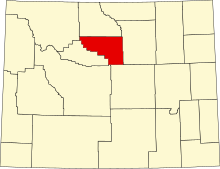
This is a list of the National Register of Historic Places listings in Big Horn County, Wyoming.

This is a list of the National Register of Historic Places listings in Johnson County, Wyoming. It is intended to be a complete list of the properties and districts on the National Register of Historic Places in Johnson County, Wyoming, United States. The locations of National Register properties and districts for which the latitude and longitude coordinates are included below, may be seen in an online map.

This is a list of the National Register of Historic Places listings in Park County, Wyoming.

This is a list of the National Register of Historic Places listings in Prince William County, Virginia.

This is a list of the National Register of Historic Places listings in Mille Lacs County, Minnesota.

This is a list of the National Register of Historic Places listings in Kandiyohi County, Minnesota. It is intended to be a complete list of the properties and districts on the National Register of Historic Places in Kandiyohi County, Minnesota, United States. The locations of National Register properties and districts for which the latitude and longitude coordinates are included below, may be seen in an online map.

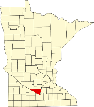
This is a list of the National Register of Historic Places listings in Swift County, Minnesota. It is intended to be a complete list of the properties and districts on the National Register of Historic Places in Swift County, Minnesota, United States. The locations of National Register properties and districts for which the latitude and longitude coordinates are included below, may be seen in an online map.

This is a list of the National Register of Historic Places listings in Meeker County, Minnesota.

This is a list of the National Register of Historic Places listings in Nobles County, Minnesota. It is intended to be a complete list of the properties and districts on the National Register of Historic Places in Nobles County, Minnesota, United States. The locations of National Register properties and districts for which the latitude and longitude coordinates are included below, may be seen in an online map.

This is a list of the National Register of Historic Places listings in Chippewa County, Wisconsin. It is intended to provide a comprehensive listing of entries in the National Register of Historic Places that are located in Chippewa County, Wisconsin. The locations of National Register properties for which the latitude and longitude coordinates are included below may be seen in a map.
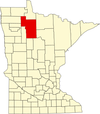
This is a list of the National Register of Historic Places listings in Beltrami County, Minnesota. This is intended to be a complete list of the properties and districts on the National Register of Historic Places in Beltrami County, Minnesota, United States. The locations of National Register properties and districts for which the latitude and longitude coordinates are included below, may be seen in an online map.

This is a list of the National Register of Historic Places listings in Big Stone County, Minnesota. It is intended to be a complete list of the properties and districts on the National Register of Historic Places in Big Stone County, Minnesota, United States. Latitude and longitude coordinates are provided for many National Register properties and districts; these locations may be seen together in an online map.
This is a list of the National Register of Historic Places listings in Yellowstone National Park.
This is a list of the National Register of Historic Places listings in Voyageurs National Park.

This is a list of the National Register of Historic Places listings in Martin County, Minnesota. It is intended to be a complete list of the properties and districts on the National Register of Historic Places in Martin County, Minnesota, United States. The locations of National Register properties and districts for which the latitude and longitude coordinates are included below, may be seen in an online map.