Current listings
| [3] | Name on the Register | Image | Date listed [4] | Location | District [5] | Description |
|---|---|---|---|---|---|---|
| 1 | American Ice Company |  | July 3, 2013 (#13000459) | 2100 W. Franklin Street 39°17′37″N76°39′08″W / 39.29374°N 76.65211°W | West | |
| 2 | Baltimore National Cemetery |  | March 8, 2016 (#16000059) | 5501 Frederick Ave. 39°16′27″N76°42′24″W / 39.274089°N 76.706776°W | Beechfield | |
| 3 | Cummins Memorial Church |  | October 31, 1979 (#79003215) | 1210 W. Lanvale St. 39°17′53″N76°38′17″W / 39.298056°N 76.638056°W | West | |
| 4 | Frederick Douglass High School | 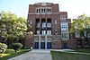 | May 18, 1989 (#89000412) | 1601 N. Calhoun St. 39°18′27″N76°38′33″W / 39.3075°N 76.6424°W | West | |
| 5 | Edmondson Avenue Historic District |  | December 27, 2010 (#10001084) | Winchester St., Braddish Ave. north of Edmondson Ave., Edmondson Ave. west of Braddish Ave., Franklintown Rd. north of W. Franklin St. 39°17′53″N76°39′47″W / 39.298056°N 76.663056°W | West | |
| 6 | Engine House No. 8 | 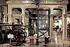 | January 26, 1995 (#94001577) | 1027 W. Mulberry St. 39°17′36″N76°38′09″W / 39.293333°N 76.635833°W | West | |
| 7 | Franklin Square Historic District | 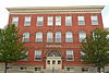 | December 10, 1982 (#82001585) | Bounded by Mulberry, N. Carey, W. Baltimore, and Monroe Sts. 39°17′29″N76°38′36″W / 39.291389°N 76.643333°W | West | |
| 8 | Franklintown Historic District |  | November 11, 2001 (#01001214) | 5100-5201 N. Franklintown Rd., 1707-1809 N. Forest Park Ave., 5100 Hamilton Ave., and 5100 Fredwall Ave. 39°18′16″N76°42′35″W / 39.304444°N 76.709722°W | Southwest | |
| 9 | Hebrew Orphan Asylum |  | October 28, 2010 (#10000868) | 2700 Rayner Ave. 39°17′48″N76°39′44″W / 39.296667°N 76.662222°W | West | |
| 10 | Hollins-Roundhouse Historic District |  | July 22, 2009 (#09000548) | W. Baltimore and Schroeder Sts., south on Schroeder to Lombard; west on Lombard to Carey, south to Pratt, and east on Pratt to Hayes 39°17′20″N76°38′02″W / 39.288764°N 76.633783°W | West | |
| 11 | James Lawrence Kernan Hospital |  | September 24, 1979 (#79003275) | Windsor Mill Rd. and Forest Park Ave. 39°18′48″N76°42′34″W / 39.313333°N 76.709444°W | Southwest | |
| 12 | Lion Brothers Company Building |  | December 7, 2006 (#06000781) | 875 Hollins St. 39°17′22″N76°37′54″W / 39.289444°N 76.631667°W | West | |
| 13 | Loudon Park National Cemetery |  | June 20, 1996 (#96000655) | 3445 Frederick Ave. 39°16′49″N76°40′31″W / 39.280278°N 76.675278°W | Southwest | |
| 14 | Old West Baltimore Historic District |  | December 23, 2004 (#04001374) | Roughly bounded by North Ave., Dolphin St., Franklin St. and Fulton Ave. 39°18′14″N76°38′17″W / 39.303889°N 76.638056°W | West | |
| 15 | Edgar Allan Poe House |  | November 11, 1971 (#71001043) | 203 Amity St. 39°17′28″N76°38′00″W / 39.291111°N 76.633333°W | West | |
| 16 | Public School No. 111 |  | September 25, 1979 (#79003219) | N. Carrollton Ave. and Riggs Rd. 39°18′03″N76°38′15″W / 39.3009°N 76.6376°W | West | |
| 17 | St. Luke's Church |  | March 30, 1973 (#73002196) | 217 N. Carey St. 39°17′28″N76°38′18″W / 39.291111°N 76.638333°W | West | |
| 18 | Schwartze Mansion |  | September 12, 1985 (#85002174) | 4206 Euclid Ave. 39°16′58″N76°41′10″W / 39.282778°N 76.686111°W | Southwest | |
| 19 | Sellers Mansion |  | December 28, 2001 (#01001369) | 801 N. Arlington St. 39°17′53″N76°38′10″W / 39.298056°N 76.636111°W | West | |
| 20 | Shaarei Tfiloh Synagogue | 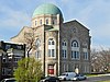 | October 10, 1996 (#96001085) | 2001 Liberty Heights Ave. 39°19′11″N76°39′04″W / 39.319722°N 76.651111°W | West | |
| 21 | Weiskittel-Roehle Burial Vault |  | May 19, 1976 (#76002185) | Section P of Loudon Park Cemetery 39°16′45″N76°40′47″W / 39.279167°N 76.679722°W | Southwest | |
| 22 | Windsor Hills Historic District |  | December 27, 2002 (#02001610) | Roughly bounded by Chelsea Terrace, Windsor Mill Rd., Talbot Rd., Westchester Rd., and Woodhaven Ave. 39°18′59″N76°41′11″W / 39.316389°N 76.686389°W | West |