Dallas County
| [2] | Name on the Register [3] | Image | Date listed [4] | Location | City or town | Description |
|---|---|---|---|---|---|---|
| 1 | 511 Akard Building |  | March 31, 2014 (#14000103) | 511 N. Akard 32°47′03″N96°48′02″W / 32.7841°N 96.8006°W | Dallas | |
| 2 | 1926 Republic National Bank |  | January 18, 2006 (#05001543) | 1309 Main St. 32°46′56″N96°48′03″W / 32.7822°N 96.8008°W | Dallas | Part of Dallas Downtown Historic District |
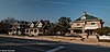
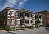
| 3 | 4928 Bryan Street Apartments | 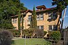 | March 23, 1995 (#08000539) | 4928 Bryan Street 32°48′16″N96°46′20″W / 32.8044°N 96.7722°W | Dallas | Historic Resources of East and South Dallas MPS |
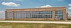
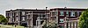
| 4 | W.H. Adamson High School |  | June 8, 2011 (#11000343) | 201 E. 9th St. 32°44′52″N96°49′19″W / 32.7478°N 96.8219°W | Dallas | |
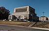
| 5 | Alcalde Street-Crockett School Historic District |  | March 23, 1995 (#95000330) | 200-500 Alcalde, 421-421A N. Carroll and 4315 Victor 32°47′33″N96°46′12″W / 32.7925°N 96.77°W | Dallas | Historic Resources of East and South Dallas MPS |
| 6 | Ambassador Hotel |  | April 4, 2019 (#100003599) | 1300 S. Ervay 32°46′22″N96°47′26″W / 32.7728°N 96.7905°W | Dallas | Destroyed by fire May 28, 2019. |
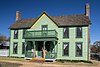
| 7 | D. M. Angle House | 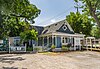 | March 27, 1985 (#85000710) | 800 Beltline 32°35′22″N96°57′30″W / 32.5894°N 96.9583°W | Cedar Hill | Historic Resources of Cedar Hill MRA |
| 8 | Bella Villa Apartments |  | September 12, 2019 (#100004371) | 5506 Miller Ave 32°49′16″N96°46′28″W / 32.8211°N 96.7744°W | Dallas | |
| 9 | Alfred Horatio Belo House |  | October 29, 1975 (#75001965) | 2115 Ross Ave. 32°47′18″N96°47′55″W / 32.7882°N 96.7985°W | Dallas | Recorded Texas Historic Landmark |
| 10 | Didaco and Ida Bianchi House |  | March 23, 1995 (#95000311) | 4503 Reiger Ave. 32°47′35″N96°46′07″W / 32.7931°N 96.7686°W | Dallas | Historic Resources of East and South Dallas MPS |
| 11 | Bluitt Sanitarium |  | July 26, 2006 (#06000651) | 2036 Commerce St. 32°46′58″N96°47′33″W / 32.7828°N 96.7925°W | Dallas | Part of Dallas Downtown Historic District |
| 12 | Braniff International Hostess College |  | March 2, 2021 (#100006219) | 2801 Wycliff Ave. 32°48′44″N96°49′01″W / 32.8123°N 96.8170°W | Dallas | |
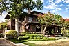
| 13 | Alfred and Juantia Bromberg House |  | July 8, 2008 (#08000658) | 3201 Wendover Road 32°49′29″N96°44′35″W / 32.8248°N 96.7430°W | Dallas | |
| 14 | Building at 3525 Turtle Creek Boulevard |  | May 29, 2008 (#08000475) | 3525 Turtle Creek Boulevard 32°48′40″N96°48′11″W / 32.8111°N 96.8031°W | Dallas | |
| 15 | Bryan-Peak Commercial Historic District |  | March 23, 1995 (#95000327) | 4214-4311 Bryan Ave. and 1325-1408 N. Peak 32°47′51″N96°46′45″W / 32.7975°N 96.7792°W | Dallas | Historic Resources of East and South Dallas MPS |
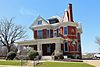
| 16 | William Bryant Jr. House |  | March 27, 1985 (#85000711) | S. Broad and Cooper 32°35′09″N96°57′25″W / 32.5858°N 96.9569°W | Cedar Hill | Historic Resources of Cedar Hill MRA |
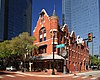
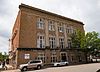
| 17 | Busch-Kirby Building |  | July 4, 1980 (#80004489) September 12, 1996 boundary increase (#96001015) | 1501-1509 Main St. 32°46′49″N96°47′56″W / 32.7803°N 96.7989°W | Dallas | Recorded Texas Historic Landmark; part of Dallas Downtown Historic District; originally listed as Busch Building before boundary increase |
| 18 | Cabana Motor Hotel | 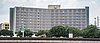 | May 8, 2019 (#100003923) | 899 N. Stemmons Frwy. 32°47′10″N96°48′48″W / 32.7862°N 96.8134°W | Dallas | |
| 19 | Cedar Springs Place |  | December 30, 1991 (#91001901) | 2531 Lucas Dr. 32°48′50″N96°49′14″W / 32.8139°N 96.8206°W | Dallas | |
| 20 | Central Congregational Church |  | March 23, 1995 (#95000307) | 1530 N. Carroll 32°48′07″N96°46′43″W / 32.8019°N 96.7786°W | Dallas | Historic Resources of East and South Dallas MPS |
| 21 | Chevrolet Motor Company Building |  | April 18, 2003 (#03000277) | 3221 Commerce 32°47′04″N96°46′36″W / 32.7844°N 96.7767°W | Dallas | |
| 22 | Claremont Apartments | 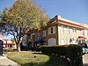 | March 23, 1995 (#95000313) | 4636 Ross Ave. 32°48′17″N96°46′37″W / 32.8047°N 96.7769°W | Dallas | Historic Resources of East and South Dallas MPS; demolished |
| 23 | Clements Hall | 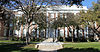 | September 27, 1980 (#80004087) | 3200 Dyer St. 32°50′36″N96°47′03″W / 32.843333°N 96.784167°W | University Park | Georgian Revival Buildings of Southern Methodist University TR |
| 24 | Colonial Hill Historic District |  | March 23, 1995 (#95000334) | Bounded by Pennsylvania Ave., I-45, US 75 and Hatcher 32°45′04″N96°45′58″W / 32.751111°N 96.766111°W | Dallas | Historic Resources of East and South Dallas MPS |
| 25 | Continental Gin Company | 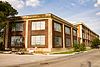 | February 14, 1983 (#83003134) | 3301-3333 Elm St., 212 and 232 Trunk Ave. 32°47′10″N96°46′37″W / 32.786111°N 96.776944°W | Dallas | |
| 26 | Dallas Coffin Company |  | June 15, 2012 (#12000350) | 1325 S. Lamar 32°46′04″N96°47′46″W / 32.76769°N 96.79604°W | Dallas | |
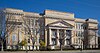
| 27 | Dallas County Courthouse |  | December 12, 1976 (#76002019) | Houston and Commerce Sts. 32°46′45″N96°48′25″W / 32.779167°N 96.806944°W | Dallas | State Antiquities Landmark, Recorded Texas Historic Landmark; part of Dealey Plaza Historic District, Westend Historic District |
| 28 | Dallas Downtown Historic District | 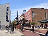 | August 11, 2006 (#04000894) January 9, 2009 boundary increase (#08001299) | Roughly bounded by Federal, N. St. Paul, Pacific, Harwood, S. Pearl, Commerce, S, Ervay, Akard, Commerce, and Field; also bounded by Jackson, North Hardwood Commerce, the north-south line between S. Pearl Expressway, and S. Hardwood Canton 32°46′57″N96°47′51″W / 32.782608°N 96.7975°W | Dallas | Includes State Antiquities Landmark, Recorded Texas Historic Landmarks |
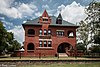
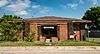
| 29 | Dallas Fire Station No. 16 |  | April 17, 1997 (#97000363) | 5501 Columbia Ave. 32°47′56″N96°45′18″W / 32.798889°N 96.755°W | Dallas | |
| 30 | Dallas Hall |  | November 17, 1978 (#78002913) | Southern Methodist University campus 32°50′42″N96°47′05″W / 32.845°N 96.784722°W | University Park | Recorded Texas Historic Landmark; Georgian Revival Buildings of Southern Methodist University TR |
| 31 | Dallas High School Historic District | 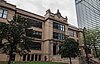 | February 20, 1996 (#96000035) | 2218 Bryan St. 32°47′10″N96°47′36″W / 32.786111°N 96.793333°W | Dallas | |
| 32 | Dallas National Bank |  | May 10, 2005 (#05000419) | 1530 Main and 1511 Commerce St. 32°46′56″N96°47′54″W / 32.782222°N 96.798333°W | Dallas | Part of Dallas Downtown Historic District |
| 33 | Dallas Scottish Rite Temple |  | March 26, 1980 (#80004088) | Harwood and Young Sts. 32°46′43″N96°47′31″W / 32.778611°N 96.791944°W | Dallas | Recorded Texas Historic Landmark; part of Dallas Downtown Historic District |
| 34 | Dallas Tent and Awning Building | 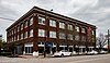 | October 28, 1999 (#99001292) | 3401 Commerce St. 32°47′06″N96°46′28″W / 32.785°N 96.774444°W | Dallas | |
| 35 | Dallas Times Herald Pasadena Perfect Home | 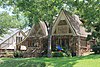 | September 13, 2006 (#06000819) | 6938 Wildgrove Ave. 32°49′08″N96°44′15″W / 32.818889°N 96.7375°W | Dallas | |
| 36 | Dallas Union Terminal |  | May 29, 1975 (#75001966) | 400 S. Houston St. 32°46′32″N96°48′27″W / 32.775556°N 96.8075°W | Dallas | Recorded Texas Historic Landmark |
| 37 | Dealey Plaza Historic District | 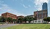 | April 19, 1993 (#93001607) | Roughly bounded by Pacific Ave., Market St., Jackson St. and right of way of Dallas Right of Way Management Company 32°46′42″N96°48′26″W / 32.778333°N 96.807222°W | Dallas | Includes State Antiquities Landmark, Recorded Texas Historic Landmarks |
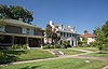
| 38 | DeGolyer Estate |  | December 28, 1978 (#78002914) | 8525 Garland Rd. 32°49′17″N96°43′03″W / 32.821389°N 96.7175°W | Dallas | State Antiquities Landmark, Recorded Texas Historic Landmark |
| 39 | Dixon-Moore House | March 23, 1995 (#95000320) | 2716 Peabody 32°48′07″N96°46′43″W / 32.801944°N 96.778611°W | Dallas | Historic Resources of East and South Dallas MPS; demolished | |
| 40 | James H. and Molly Ellis House |  | March 23, 1995 (#95000323) | 2426 Pine, until destruction by fire in 2019 32°45′17″N96°45′42″W / 32.754722°N 96.761667°W | Dallas | Historic Resources of East and South Dallas MPS; demolished |
| 41 | Emanuel Lutheran Church |  | March 23, 1995 (#95000315) | 4301 San Jacinto 32°48′02″N96°46′51″W / 32.800556°N 96.780833°W | Dallas | Historic Resources of East and South Dallas MPS |
| 42 | James W. Fannin Elementary School |  | March 23, 1995 (#95000314) | 4800 Ross Ave. 32°48′19″N96°46′32″W / 32.805278°N 96.775556°W | Dallas | Historic Resources of East and South Dallas MPS |
| 43 | Fidelity Union Life Insurance Building |  | September 29, 2009 (#09000306) | 1511 Bryan and 1507 Pacific Ave. 32°46′57″N96°47′59″W / 32.7825°N 96.799722°W | Dallas | |
| 44 | First National Bank Tower |  | October 23, 2017 (#100001764) | 1401 Elm St. 32°46′54″N96°48′02″W / 32.781630°N 96.800451°W | Dallas | |
| 45 | Fred Florence Hall | 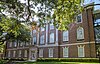 | September 27, 1980 (#80004089) | 3330 University Blvd. 32°50′43″N96°47′10″W / 32.845278°N 96.786111°W | University Park | Georgian Revival Buildings of Southern Methodist University TR |
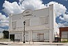
| 46 | Forest Theatre |  | December 4, 2019 (#100004752) | 1904 Martin Luther King Jr. Blvd. 32°45′50″N96°46′28″W / 32.7638°N 96.7745°W | Dallas | |
| 47 | Old Forest Avenue High School | 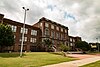 | March 23, 1995 (#95000318) | 3000 Martin Luther King, Jr., Blvd. 32°46′16″N96°45′53″W / 32.771111°N 96.764722°W | Dallas | Historic Resources of East and South Dallas MPS |
| 48 | G & J Manufacturing | 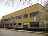 | September 14, 2002 (#02000992) | 3912 Willow St. 32°47′08″N96°46′13″W / 32.785556°N 96.770278°W | Dallas | |
| 49 | Garland Bank & Trust Company | 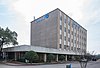 | January 20, 2023 (#100008552) | 111 South Garland Ave. 32°54′43″N96°38′55″W / 32.911845°N 96.648516°W | Garland | |
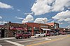
| 50 | Garland Downtown Historic District |  | April 10, 2017 (#100000861) July 24, 2017 boundary increase (#100001373) | Roughly bounded by W. State St., Santa Fe rail line, W. Ave. A & Glenbrook Dr. 32°54′46″N96°38′20″W / 32.912680°N 96.638857°W | Garland | |
| 51 | Samuel and Julia Gilbert House | 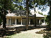 | November 10, 1988 (#88002063) | 2540 Farmers Branch Ln. 32°55′05″N96°53′26″W / 32.918056°N 96.890556°W | Farmers Branch | Recorded Texas Historic Landmark |
| 52 | Goodyear Tire and Rubber Company Building and B.F. Goodrich Building |  | February 19, 2002 (#02000009) | 2809 Parry Ave. and 4136-40 Commerce St. 32°46′29″N96°45′56″W / 32.774722°N 96.765556°W | Dallas | |
| 53 | Gospel Lighthouse Church |  | February 9, 2022 (#100007423) | 1900 South Ewing Ave. 32°43′29″N96°48′39″W / 32.7248°N 96.8107°W | Dallas | |
| 54 | Grace Methodist Episcopal Church | 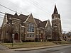 | November 4, 1982 (#82001736) | 4105 Junius St. 32°47′36″N96°46′32″W / 32.793333°N 96.775556°W | Dallas | Part of Peak's Suburban Addition Historic District |
| 55 | Grand Lodge of the Colored Knights of Pythias, Texas |  | February 17, 2017 (#100000671) | 2551 Elm St. 32°47′03″N96°47′14″W / 32.784186°N 96.787141°W | Dallas | |
| 56 | Greenway Parks Historic District | 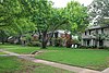 | January 10, 2008 (#07001383) | Bounded by W. Mockingbird Ln., W. University Blvd., Inwood & N. Dallas Tollway. 32°50′27″N96°49′04″W / 32.840709°N 96.817814°W | Dallas | Historic Residential Suburbs in the United States, 1830-1960 MPS |
| 57 | George C. Greer House |  | January 9, 1997 (#96001563) | 5439 Swiss Ave. 32°48′23″N96°45′53″W / 32.806389°N 96.764722°W | Dallas | Part of Swiss Avenue Historic District |
| 58 | Gulf Oil Distribution Facility |  | March 31, 2010 (#10000144) | 501 S. 2nd St. 32°46′56″N96°46′22″W / 32.782222°N 96.772778°W | Dallas | |
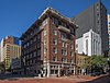
| 59 | Harlan Building |  | February 26, 2004 (#04000102) | 2018 Cadiz St. 32°46′49″N96°47′28″W / 32.780278°N 96.791111°W | Dallas | |
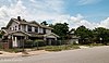
| 60 | Z. T. (Tip) Hawkes House | 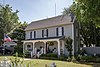 | March 27, 1985 (#85000712) | 132 N. Potter St. 32°35′28″N96°57′33″W / 32.591111°N 96.959167°W | Cedar Hill | Historic Resources of Cedar Hill MRA |
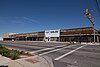
| 61 | Highland Park Shopping Village |  | November 17, 1997 (#97001393) | Jct. of Preston Rd. and Mockingbird Ln. 32°50′08″N96°48′18″W / 32.835556°N 96.805°W | Highland Park | |
| 62 | Hilton Hotel | 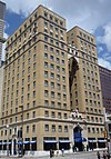 | December 5, 1985 (#85003092) | 1933 Main St. 32°46′54″N96°47′39″W / 32.781667°N 96.794167°W | Dallas | Recorded Texas Historic Landmark; part of Dallas Downtown Historic District |
| 63 | Hotel Adolphus |  | July 14, 1983 (#83003133) | 1315 Commerce St. 32°46′47″N96°47′57″W / 32.779722°N 96.799167°W | Dallas | Recorded Texas Historic Landmark; part of Dallas Downtown Historic District |
| 64 | Houston Street Viaduct | 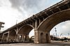 | August 9, 1984 (#84001641) | Houston St. roughly between Arlington St. and Lancaster Ave. 32°46′12″N96°48′31″W / 32.77°N 96.808611°W | Dallas | |
| 65 | Hughes Brothers Manufacturing Company Building |  | December 27, 2016 (#16000915) | 1401 S. Ervay St. 32°46′20″N96°47′25″W / 32.772226°N 96.790345°W | Dallas | |
| 66 | Hyer Hall |  | September 27, 1980 (#80004090) | 6424 Hill Lane 32°50′41″N96°47′02″W / 32.844722°N 96.783889°W | University Park | Georgian Revival Buildings of Southern Methodist University TR |
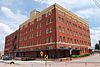
| 67 | Interstate Forwarding Company Warehouse |  | February 14, 1992 (#92000021) | 3200 Main St. 32°47′05″N96°46′37″W / 32.784722°N 96.776944°W | Dallas | Recorded Texas Historic Landmark |
| 68 | Joffre-Gilbert House |  | August 1, 2014 (#14000473) | 309 South O'Connor Road 32°48′41″N96°57′01″W / 32.811412°N 96.950369°W | Irving | Recorded Texas Historic Landmark |
| 69 | Johnson Rooming House | 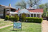 | November 26, 2014 (#14000962) | 1026 N. Beckley Avenue 32°45′32″N96°49′21″W / 32.758804°N 96.822584°W | Dallas | |
| 70 | Kessler Park Historic District |  | June 17, 1994 (#94000607) September 7, 1995 boundary increase (#95001087) | Roughly bounded by Kidd Springs, Stewart, Oak Cliff, Plymouth, I-30, Turner, Colorado, and Sylvan 32°45′25″N96°50′39″W / 32.756944°N 96.844167°W | Dallas | Historic and Architectural Resources of Oak Cliff MPS |
| 71 | King's Highway Historic District | 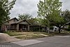 | June 17, 1994 (#94000606) | 900-1500 Blocks of King's Highway between W. Davis St. and Montclair Ave. 32°45′07″N96°50′32″W / 32.751944°N 96.842222°W | Dallas | Historic and Architectural Resources of Oak Cliff MPS |
| 72 | Lake Cliff Historic District |  | June 17, 1994 (#94000609) | Roughly bounded by E. 6th St., Beckley Ave., Zangs Blvd. and Marsalis Ave. 32°45′23″N96°49′06″W / 32.756389°N 96.818333°W | Dallas | Historic and Architectural Resources of Oak Cliff MPS |
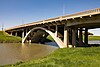
| 73 | Lamar-McKinney Bridge |  | October 5, 2015 (#15000708) | Across Trinity River at Continental Avenue 32°46′52″N96°49′20″W / 32.781106°N 96.822302°W | Dallas | |
| 74 | Lancaster Avenue Commercial Historic District |  | June 17, 1994 (#94000605) | Roughly bounded by E. Jefferson Blvd., S. Marsalis, E. 10th St., E. 9th St. and N. Lancaster Ave. 32°44′54″N96°48′53″W / 32.748333°N 96.814722°W | Dallas | Historic and Architectural Resources of Oak Cliff MPS |
| 75 | Stephen Decatur Lawrence Farmstead |  | September 9, 1999 (#99001139) | 701 E. Kearney St. 32°46′13″N96°35′20″W / 32.770278°N 96.588889°W | Mesquite | Recorded Texas Historic Landmark |
| 76 | Mark and Maybelle Lemmon House |  | June 15, 2006 (#06000513) | 3211 Mockingbird Ln. 32°50′17″N96°47′04″W / 32.838056°N 96.784444°W | Highland Park | Recorded Texas Historic Landmark |
| 77 | Levi-Moses House |  | March 23, 1995 (#95000316) | 2433 Martin Luther King, Jr., Blvd. 32°45′56″N96°46′20″W / 32.765556°N 96.772222°W | Dallas | Historic Resources of East and South Dallas MPS |
| 78 | Levi-Topletz House | 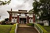 | March 23, 1995 (#95000317) | 2603 Martin Luther King, Jr., Blvd. 32°46′02″N96°46′13″W / 32.767222°N 96.770278°W | Dallas | Historic Resources of East and South Dallas MPS |
| 79 | Lincoln Paint and Color Company Building |  | July 11, 2002 (#02000730) | 3210 Main 32°47′06″N96°46′36″W / 32.785°N 96.776667°W | Dallas | |
| 80 | Magnolia Building |  | January 30, 1978 (#78002915) | 108 S. Akard St. 32°46′48″N96°47′56″W / 32.78°N 96.798889°W | Dallas | Recorded Texas Historic Landmark; part of Dallas Downtown Historic District |
| 81 | Magnolia Petroleum Company City Sales and Warehouse | 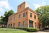 | December 23, 1994 (#94001473) | 1607 Lyte St. 32°47′33″N96°48′37″W / 32.7925°N 96.810278°W | Dallas | |
| 82 | Majestic Theatre |  | November 14, 1977 (#77001437) | 1925 Elm St. 32°47′01″N96°47′40″W / 32.783611°N 96.794444°W | Dallas | State Antiquities Landmark, Recorded Texas Historic Landmark; part of Dallas Downtown Historic District |
| 83 | Mary Apartments | 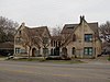 | March 23, 1995 (#95000310) | 4524 Live Oak 32°47′58″N96°46′30″W / 32.799444°N 96.775°W | Dallas | Historic Resources of East and South Dallas MPS |
| 84 | Mayflower Building |  | January 27, 2015 (#14001227) | 411 North Akard Street 32°46′59″N96°48′03″W / 32.783029°N 96.800863°W | Dallas | |
| 85 | McFarlin Memorial Auditorium |  | September 27, 1980 (#80004091) | 6405 Hillcrest Rd. 32°50′38″N96°47′10″W / 32.843889°N 96.786111°W | University Park | Georgian Revival Buildings of Southern Methodist University TR |
| 86 | McGaugh Hosiery Mills - Airmaid Mills Building |  | August 8, 2019 (#100004249) | 4408 2nd Ave. 32°45′52″N96°44′52″W / 32.764360°N 96.747887°W | Dallas | |
| 87 | Roger D. McIntosh House |  | April 7, 1983 (#83003135) | 1518 Abrams Rd. 32°48′25″N96°45′13″W / 32.806944°N 96.753611°W | Dallas | |
| 88 | Medical Dental Building |  | December 13, 2000 (#00001537) | 300 Blk. of West Jefferson Blvd. 32°44′36″N96°49′37″W / 32.743333°N 96.826944°W | Dallas | Historic and Architectural Resources of Oak Cliff MPS |
| 89 | Miller and Stemmons Historic District |  | June 17, 1994 (#94000611) | Roughly bounded by W. Davis St., Woodlawn Ave., Neches and Elsbeth 32°45′09″N96°49′39″W / 32.7525°N 96.8275°W | Dallas | Historic and Architectural Resources of Oak Cliff MPS |
| 90 | John Hickman Miller House |  | May 23, 1980 (#80004092) | 3506 Cedar Springs 32°48′24″N96°48′20″W / 32.806667°N 96.805556°W | Dallas | Recorded Texas Historic Landmark |
| 91 | John E. Mitchell Company Plant | 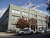 | March 4, 1991 (#91000118) | 3800 Commerce St. 32°47′05″N96°46′16″W / 32.784722°N 96.771111°W | Dallas | |
| 92 | Monroe Shops | 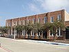 | March 7, 2007 (#07000130) | 2111 S. Corinth St. 32°43′27″N96°48′15″W / 32.724167°N 96.804167°W | Dallas | |
| 93 | Mrs. Baird's Bread Company Building | 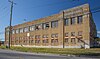 | March 23, 1995 (#95000309) | 1401 N. Carroll 32°48′01″N96°46′36″W / 32.800278°N 96.776667°W | Dallas | Historic Resources of East and South Dallas MPS |
| 94 | Munger Place Historic District |  | September 13, 1978 (#78002916) | Roughly bounded by Henderson, Junius, Prairie, and Reiger Sts. 32°47′58″N96°45′51″W / 32.799444°N 96.764167°W | Dallas | |
| 95 | North Bishop Avenue Commercial Historic District | 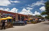 | June 17, 1994 (#94000608) | Roughly bounded by 9th St., Davis St., Adams and Madison 32°44′50″N96°49′42″W / 32.747222°N 96.828333°W | Dallas | Historic and Architectural Resources of Oak Cliff MPS |
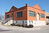
| 96 | Number 4 Hook and Ladder Company |  | May 4, 1981 (#81000627) | Cedar Springs Rd. and Reagan St. 32°48′35″N96°48′32″W / 32.809722°N 96.808889°W | Dallas | |
| 97 | Oak Lawn Methodist Episcopal Church, South | 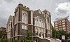 | March 16, 1988 (#88000176) | 3014 Oak Lawn Ave. 32°48′33″N96°48′29″W / 32.809167°N 96.808056°W | Dallas | |
| 98 | One Main Place |  | May 15, 2015 (#15000245) | 1201 Main Street 32°46′50″N96°48′07″W / 32.780428°N 96.801996°W | Dallas | |
| 99 | Paine House |  | November 26, 2014 (#14000963) | 2515 West 5th Street 32°48′35″N96°58′46″W / 32.809725°N 96.979311°W | Irving | Location where Lee Harvey Oswald stayed the night before the assassination of President John F. Kennedy. |
| 100 | Parkland Hospital |  | October 25, 2011 (#10000249) | 3819 Maple Avenue 32°48′15″N96°48′56″W / 32.804236°N 96.815417°W | Dallas | Original Parkland Hospital building |
| 101 | Stanley Patterson Hall | 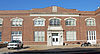 | September 27, 1980 (#80004094) | 3128 Dyer St. 32°50′36″N96°46′56″W / 32.843333°N 96.782222°W | University Park | Georgian Revival Buildings of Southern Methodist University TR |
| 102 | Peak's Suburban Addition Historic District |  | March 23, 1995 (#95000328) | Roughly bounded by Sycamore, Peak, Worth and Fitzhugh 32°47′44″N96°46′24″W / 32.795556°N 96.773333°W | Dallas | Historic Resources of East and South Dallas MPS |
| 103 | Perkins Hall of Administration |  | September 27, 1980 (#80004095) | 6425 Hillcrest Rd. 32°50′41″N96°47′09″W / 32.844722°N 96.785833°W | University Park | Georgian Revival Buildings of Southern Methodist University TR |
| 104 | Purvin-Hexter Building | 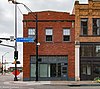 | January 18, 2006 (#05001541) | 2038 Commerce St. 32°46′58″N96°47′35″W / 32.782778°N 96.793056°W | Dallas | Part of Dallas Downtown Historic District |
| 105 | Queen City Heights Historic District | 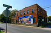 | March 23, 1995 (#95000332) | Roughly bounded by Eugene, Cooper, Latimer, Kynard and Dildock 32°45′36″N96°45′47″W / 32.76°N 96.763056°W | Dallas | Historic Resources of East and South Dallas MPS |
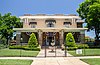
| 106 | Randlett House |  | August 11, 1978 (#78002920) | 401 S. Centre St. 32°35′26″N96°45′20″W / 32.590556°N 96.755556°W | Lancaster | |
| 107 | Capt. R. A. Rawlins House | 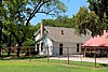 | November 15, 1978 (#78002921) | 2219 Dowling St. 32°34′49″N96°45′22″W / 32.580278°N 96.756111°W | Lancaster | Recorded Texas Historic Landmark |
| 108 | Republic National Bank |  | March 31, 2005 (#05000243) | 300 N. Ervay/325 N. St. Paul St. 32°47′06″N96°47′51″W / 32.785°N 96.7975°W | Dallas | Part of Dallas Downtown Historic District |
| 109 | Dr. Rufus A. Roberts House | 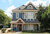 | March 27, 1985 (#85000713) | 210 S. Broad St. 32°35′17″N96°57′26″W / 32.588056°N 96.957222°W | Cedar Hill | Recorded Texas Historic Landmark; Historic Resources of Cedar Hill MRA |
| 110 | Romine Avenue Historic District |  | March 23, 1995 (#95000333) | 2300-2400 blocks of Romine Ave., N side 32°45′32″N96°45′54″W / 32.758889°N 96.765°W | Dallas | Historic Resources of East and South Dallas MPS |
| 111 | Rosemont Crest Historic District |  | June 17, 1994 (#94000610) | Roughly bounded by 10th St., Oak Cliff Blvd., W. Davis St., N. Brighton Ave., W. 8th St. and Rosemont Ave. 32°44′48″N96°51′02″W / 32.746667°N 96.850556°W | Dallas | Historic and Architectural Resources of Oak Cliff MPS |
| 112 | Rush-Crabb House |  | March 23, 1995 (#95000321) | 2718 Pennsylvania 32°46′02″N96°46′02″W / 32.767100°N 96.767125°W | Dallas | Historic Resources of East and South Dallas MPS |
| 113 | Sanger Brothers Complex |  | April 8, 1975 (#75001967) | Block 32, bounded by Elm, Lamar, Main and Austin Sts. 32°46′47″N96°48′15″W / 32.779722°N 96.804167°W | Dallas | Part of Westend Historic District |
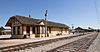
| 114 | Santa Fe Terminal Buildings No. 1 and No. 2 |  | May 23, 1997 (#97000478) | 1114 Commerce St. and 1118 Jackson St. 32°47′48″N96°48′03″W / 32.796667°N 96.800833°W | Dallas | |
| 115 | Santa Fe Terminal Building No. 4 | 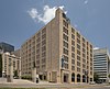 | June 8, 2011 (#11000344) | 1033 Young St. 32°46′37″N96°48′04″W / 32.776944°N 96.801111°W | Dallas | |
| 116 | Everard Sharrock Jr. Farm |  | December 8, 2015 (#15000877) | 6900 Grady Niblo Rd. 32°41′02″N96°56′23″W / 32.684°N 96.939675°W | Dallas | Recorded Texas Historic Landmark |
| 117 | Thomas Shiels House |  | March 23, 1995 (#95000312) | 4602 Reiger Ave. 32°47′37″N96°46′02″W / 32.793611°N 96.767222°W | Dallas | Historic Resources of East and South Dallas MPS |
| 118 | Ascher Silberstein School |  | March 23, 1995 (#95000325) | 2425 Pine St. 32°45′21″N96°45′40″W / 32.755833°N 96.761111°W | Dallas | Historic Resources of East and South Dallas MPS |
| 119 | Snider Hall | 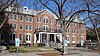 | September 27, 1980 (#80004096) | 3305 Dyer St. 32°50′33″N96°47′09″W / 32.8425°N 96.785833°W | University Park | Georgian Revival Buildings of Southern Methodist University TR |
| 120 | South Boulevard–Park Row Historic District |  | February 5, 1979 (#79002930) | South Blvd. and Park Row from Central 32°46′05″N96°46′20″W / 32.768056°N 96.772222°W | Dallas | |
| 121 | Jacob and Eliza Spake House | 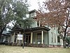 | November 21, 1985 (#85002912) | 2600 State St. 32°47′43″N96°47′58″W / 32.795278°N 96.799444°W | Dallas | |
| 122 | St. Paul Methodist Episcopal Church |  | December 27, 2016 (#16000916) | 1816 Routh St. 32°47′32″N96°47′47″W / 32.792211°N 96.796477°W | Dallas | Recorded Texas Historic Landmark |
| 123 | Stanard-Tilton Flour Mill |  | October 6, 1997 (#97001187) | 2400 S. Ervay St. 32°46′00″N96°46′55″W / 32.766667°N 96.781944°W | Dallas | |
| 124 | Stoneleigh Court Hotel | 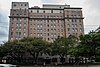 | September 18, 2007 (#07000989) | 2927 Maple Ave. 32°47′51″N96°48′25″W / 32.7975°N 96.806944°W | Dallas | |
| 125 | Strain Farm-W.A. Strain House | 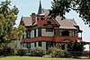 | November 29, 1978 (#78002922) September 17, 2001 boundary increase (#01001002) | 400 E. Pecan St., 400 Lancaster-Hutchins Rd. 32°35′16″N96°44′58″W / 32.587778°N 96.749444°W | Lancaster | Includes State Antiquities Landmarks, Recorded Texas Historic Landmark |
| 126 | Straus House |  | July 12, 1985 (#85001495) | 400 Cedar 32°35′18″N96°57′15″W / 32.588333°N 96.954167°W | Cedar Hill | Historic Resources of Cedar Hill MRA |
| 127 | Swiss Avenue Historic District |  | March 28, 1974 (#74002068) | Swiss Ave. between Fitzhugh and LaVista 32°48′25″N96°45′49″W / 32.806944°N 96.763611°W | Dallas | Includes Recorded Texas Historic Landmarks |
| 128 | Tenth Street Historic District |  | June 17, 1994 (#94000604) | Roughly bounded by E. Clarendon Dr., S. Fleming Ave., I-35E, E. 8th St. and the E end of Church, E. 9th and Plum Sts. 32°44′52″N96°48′23″W / 32.747778°N 96.806389°W | Dallas | Historic and Architectural Resources of Oak Cliff MPS |
| 129 | Texas Centennial Exposition Buildings (1936-1937) |  | September 24, 1986 (#86003488) | Bounded by Texas and Pacific RR, Pennsylvania, Second, and Parry Aves. 32°46′46″N96°45′35″W / 32.779444°N 96.759722°W | Dallas | Includes State Antiquities Landmarks, Recorded Texas Historic Landmarks |
| 130 | Texas Farm and Ranch Building |  | December 9, 1999 (#99001499) | 3300 Main St. 32°47′07″N96°46′31″W / 32.785278°N 96.775278°W | Dallas | |
| 131 | Texas Theatre |  | April 1, 2003 (#03000187) | 231 W. Jefferson Blvd. 32°44′36″N96°49′32″W / 32.743333°N 96.825556°W | Dallas | Historic and Architectural Resources of Oak Cliff MPS |
| 132 | Titche-Goettinger Building |  | May 24, 1996 (#96000586) | 1901 Main St. 32°47′26″N96°47′42″W / 32.790556°N 96.795°W | Dallas | Part of Dallas Downtown Historic District |
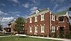
| 133 | Travis College Hill Historic District |  | February 17, 2017 (#100000672) | 300-400 blocks S. 11th St. 32°54′36″N96°38′36″W / 32.909977°N 96.643458°W | Garland | |
| 134 | Trinity English Lutheran Church |  | March 23, 1995 (#95000319) | 3100 Martin Luther King, Jr., Blvd. 32°46′19″N96°45′52″W / 32.771944°N 96.764444°W | Dallas | Historic Resources of East and South Dallas MPS |
| 135 | Turtle Creek Pump Station | 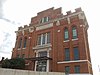 | February 9, 2001 (#01000103) | 3630 Harry Hines Blvd. 32°48′00″N96°48′59″W / 32.8°N 96.816389°W | Dallas | State Antiquities Landmark, Recorded Texas Historic Landmark |
| 136 | Viola Courts Apartments |  | January 19, 1984 (#84001643) | 4845 Swiss Ave. 32°48′04″N96°46′15″W / 32.801111°N 96.770833°W | Dallas | Part of Peak's Suburban Addition Historic District |
| 137 | Virginia Hall | 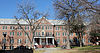 | September 27, 1980 (#80004097) | 3325 Dyer St. 32°50′34″N96°47′11″W / 32.842778°N 96.786389°W | University Park | Georgian Revival Buildings of Southern Methodist University TR |
| 138 | Waples-Platter Buildings | 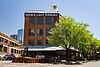 | March 24, 1978 (#78002917) | 2200-2211 N. Lamar St. 32°47′04″N96°48′30″W / 32.784444°N 96.808333°W | Dallas | |
| 139 | Wedgwood Apartments |  | May 25, 2021 (#100006549) | 2511 Wedglea Dr. 32°45′29″N96°51′37″W / 32.7580°N 96.8604°W | Dallas | |
| 140 | Westend Historic District |  | November 14, 1978 (#78002918) | Bounded by Lamar, Griffin, Wood, Market, and Commerce Sts. 32°46′44″N96°48′21″W / 32.778889°N 96.805833°W | Dallas | Includes State Antiquities Landmark, Recorded Texas Historic Landmarks |
| 141 | Wheatley Place Historic District |  | March 23, 1995 (#95000331) | Bounded by Warren, Atlanta, McDermott, Meadow, Oakland and Dathe 32°45′54″N96°45′43″W / 32.765°N 96.761944°W | Dallas | includes Recorded Texas Historic Landmark; Historic Resources of East and South Dallas MPS |
| 142 | Wilson Block | 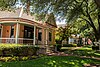 | December 15, 1978 (#78002919) | 2902, 2906, 2910 and 2922 Swiss Ave. 32°47′18″N96°47′05″W / 32.788333°N 96.784722°W | Dallas | |
| 143 | Wilson Building |  | July 24, 1979 (#79002931) | 1621-1623 Main St. 32°46′53″N96°47′49″W / 32.781389°N 96.796944°W | Dallas | Part of Dallas Downtown Historic District |
| 144 | Winnetka Heights Historic District |  | November 3, 1983 (#83003758) | Roughly bounded by Davis and 12th Sts., and Rosemont and Willomet Aves. 32°44′39″N96°50′41″W / 32.744167°N 96.844722°W | Dallas |