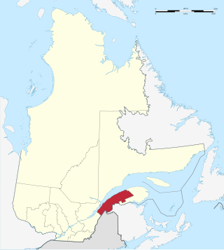
The Bas-Saint-Laurent, is an administrative region of Quebec located along the south shore of the lower Saint Lawrence River in Quebec. The river widens at this place, later becoming a bay that discharges into the Atlantic Ocean and is often nicknamed "Bas-du-Fleuve" (Lower-River). The region is formed by eight regional county municipalities and 114 municipalities. In the south, it borders Maine of the United States, and the Canadian New Brunswick and the regions of Chaudière-Appalaches and Gaspésie–Îles-de-la-Madeleine.

The Gironde estuary is a navigable estuary in southwest France and is formed from the meeting of the rivers Dordogne and Garonne just downstream of the centre of Bordeaux. Covering around 635 km2 (245 sq mi), it is the largest estuary in western Europe.

A nature reserve is a protected area of importance for flora, fauna, funga, or features of geological or other special interest, which is reserved and managed for purposes of conservation and to provide special opportunities for study or research. They may be designated by government institutions in some countries, or by private landowners, such as charities and research institutions. Nature reserves fall into different IUCN categories depending on the level of protection afforded by local laws. Normally it is more strictly protected than a nature park. Various jurisdictions may use other terminology, such as ecological protection area or private protected area in legislation and in official titles of the reserves.

The Magdalen Islands are an archipelago of a dozen islands that are the backbone of the municipality of Les-Îles-de-la-Madeleine, in the Gaspésie-Îles-de-la-Madeleine region, Quebec.
Lake Saint Pierre is a lake in Quebec, Canada, a widening of the Saint Lawrence River between Sorel-Tracy and Trois-Rivières. It is located downstream, and northeast, of Montreal; and upstream, and southwest, of Quebec City. The end of the lake delimits the beginning of the estuary of Saint Lawrence.

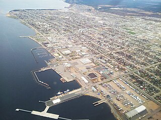
Rimouski is a city in Quebec, Canada. Rimouski is located in the Bas-Saint-Laurent region, at the mouth of the Rimouski River. It has a population of 48,664. Rimouski is the site of Université du Québec à Rimouski (UQAR), the Cégep de Rimouski and the Music Conservatory. It is also the home of some ocean sciences research centres.
Sept-Îles is a city in the Côte-Nord region of eastern Quebec. It is among the northernmost locales with a paved connection to the rest of Quebec's road network. The population was 25,686 as of the 2011 Canadian census. The town is called Uashat, meaning "bay" in Innu-aimun.
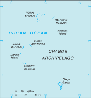
The British Indian Ocean Territory (BIOT) is an archipelago of 55 islands in the Indian Ocean, located south of India. It is situated approximately halfway between Africa and Indonesia. The islands form a semicircular group with an open sea towards the east. The largest, Diego Garcia, is located at the southern extreme end. It measures 60 square kilometres (23 sq mi) and accounts for almost three-quarters of the total land area of the territory. Diego Garcia is the only inhabited island and is home to the joint UK-US naval support facility. Other islands within the archipelago include Danger Island, Three Brothers Islands, Nelson Island, and Peros Banhos, as well as the island groups of the Egmont Islands, Eagle Islands, and the Salomon Islands.

The Marquesas Keys form an uninhabited island group about 20 miles (32 km) west of Key West, four miles (6 km) in diameter, and largely covered by mangrove forest. They are an unincorporated area of Monroe County, Florida and belong to the Lower Keys Census County Division. They are protected as part of the Key West National Wildlife Refuge. The Marquesas were used for target practice by the military as recently as 1980.

Protected areas of Canada consist of approximately 12.1 percent of the nation's landmass and freshwater are considered conservation areas, including 11.4 percent designated as protected areas. Approximately 13.8 percent of Canada's territorial waters are conserved, including 8.9 percent designated as protected areas. Terrestrial areas conserved have increased by 65 percent in the 21st century, while marine areas conserved have increased by more than 3,800 percent.

The Rural Municipality of Ritchot is a rural municipality (RM) in the Winnipeg Capital Region, bordering the south side of Winnipeg in Manitoba, Canada. The separately-administered town of Niverville lies adjacent to its southeast, between it and the Rural Municipality of Hanover.

Dundee is a township municipality in Le Haut-Saint-Laurent Regional County Municipality in the Montérégie administrative region of Quebec, Canada. At the 2021 Canadian census, the population was 386. It is primarily an agricultural area consisting of dairy and grain farms.
The wildlife of Canada or biodiversity of Canada consist of over 80,000 classified species, and an equal number thought yet to be recognized. Known fauna and flora have been identified from five kingdoms: protozoa represent approximately 1% of recorded species; chromist ; fungis ; plants ; and animals. Insects account for nearly 70 percent of documented animal species in Canada. More than 300 species are found exclusively in Canada.

Antler Lake is a hamlet in Alberta, Canada within Strathcona County. It is located on the shores of Antler Lake on Range Road 211 and 211A just north of Wye Road, approximately 18 km (11 mi) east of Sherwood Park and 25 km (16 mi) northwest of Tofield.

Nirjutiqavvik National Wildlife Area is a National Wildlife Area on Coburg Island within the Qikiqtaaluk Region, Nunavut, Canada. It is located in Baffin Bay's Lady Ann Strait between Ellesmere Island, to the north, and Devon Island to the south. The NWA includes Coburg Island and its surrounding marine area.

The Kendall Island Migratory Bird Sanctuary (KIBS) is a migratory bird sanctuary in the Northwest Territories, Canada. It is located on Kendall Island and its surrounding area in Mackenzie Bay at the northern tip of the Mackenzie River Delta. A seasonal sanctuary for more than 60,000 shorebirds, it is one of five bird sanctuaries within the Inuvialuit Settlement Region. The area that is now known as the KIBS is a traditional Inuvialuit whaling site.
L’Île aux Lièvres is an island of the St. Lawrence River, located between Saint-Siméon and Rivière-du-Loup, near the islands of the Pot à l'Eau-de-Vie. This island is part of the municipality of Saint-André-de-Kamouraska, in the Kamouraska Regional County Municipality, in the administrative region of Bas-Saint-Laurent, in the province of Quebec, in Canada.
Scott Islands Marine National Wildlife Area is a National Wildlife Area off the northwestern tip of Vancouver Island in the Canadian province of British Columbia. Covering an area of 11,570.65 km2 (4,467.45 sq mi), it is the second largest protected area in British Columbia after Offshore Pacific Seamounts and Vents Closure and is the largest national wildlife area in Canada.

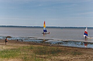
The Pointe-au-Père National Wildlife Area is one of eight National Wildlife Areas of Canada located in Quebec. This small 23-hectare area protects a spartina marsh located in the Pointe-au-Père sector of the city of Rimouski. In addition to the marsh, it includes an eelgrass meadow. Despite its small size, it is frequented by over 120 species of birds, including snow geese, Barrow's goldeneye, least sandpiper and greater yellowlegs. It was created in 1986 following pressure from a group of residents to protect the marsh. It is administered by the Canadian Wildlife Service.