Navigation Structures at Frankfort Harbor

Last updated
Navigation Structures at Frankfort Harbor
Frankfort Harbor 2.JPG
USA Michigan location map.svg
Red pog.svg
Frankfort Harbor
Location in Michigan
Usa edcp location map.svg
Red pog.svg
Frankfort Harbor
Location in United States
Location2nd St., Frankfort, Michigan
Coordinates 44°37′49″N86°14′52″W / 44.63028°N 86.24778°W / 44.63028; -86.24778 Coordinates: 44°37′49″N86°14′52″W / 44.63028°N 86.24778°W / 44.63028; -86.24778
Area2.4 acres (0.97 ha)
Built1867 (1867)
ArchitectBrigadier General T.J. Cram, Whitwood and Hubell
Architectural styleUtilitarian
NRHP reference No. 97000973 [1]
Added to NRHPSeptember 12, 1997

The Navigation Structures at Frankfort Harbor are a collection of breakwaters, piers, and other structures in Lake Michigan located at the foot of Second Street in Frankfort, Michigan. They were listed on the National Register of Historic Places in 1997. [1]

Contents

History

In 1854, running from a violent storm, Buffalo captain George Tifft ran his schooner over a sandbar and into the protection of Lake Betsie. [2] After the storm, while digging back out, Tifft took the opportunity to explore the area and realized it was an ideal location for a harbor. Soon after Tifft brought word of his discovery back home, a number of people began purchasing property around the lake. In 1859, private interests constructed two short piers and dredged out a channel between them, connecting Betsie Lake to Lake Michigan.

The harbor quickly became a popular refuge, and in 1867, Congress directed the Army Corps of Engineers to begin improvements on the harbor. [2] A new channel was cut, and by 1873 two new wooden piers had been constructed and a beacon installed at the pierhead. As the harbor became more utilized, the piers were extended in 1884 and again in 1896, and a new lighthouse (the Frankfort Light, also on the National Register of Historic Places) was installed on the north pier in 1912.

In 1928, construction began on a pair of concrete breakwaters at the harbor entrance. [3] Construction was complete by 1932. With the earlier piers now rendered obsolete, plans were made to shorten them, [4] and the 1912 lighthouse was removed from the north pier and relocated at the head of the north breakwater. In 1934 the remaining stub piers were capped with concrete. [3] Piecemeal repairs were done on sections of the piers in the 1950s and 60s.

Description

Frankfort MI harbor map Frankfort harbor map.jpg
Frankfort MI harbor map
Aerial view Frankfort Harbor.jpg
Aerial view

The exterior basin of the Frankfort Harbor is formed by two breakwaters, 450 feet (140 m) apart at the outer ends. [5] The main section of the north breakwater is 972 feet (296 m) long, with a shore connector of 1,000 feet (300 m). The main section of the south breakwater is 1,188 feet (362 m) long, with a shore connector of 1,400 feet (430 m). Two stub piers line the entrance to the harbor within the breakwaters. [3]

The piers are stone-filled timber cribs, 20 feet (6.1 m) wide, with the exception of the shoreward portion of the south pier, which is constructed of wooden pilings filled with sand. [3] The original piers were wrapped in sheet piling in the 1950s-60s, and the entire structure capped in concrete; the piers now range from 27 feet (8.2 m) to 33 feet (10 m) wide. The lakeward sections of the breakwaters are stone-filled concrete, with riprap piled against the outside. The shoreward sections are wood pilings filled with stone and capped with concrete. The breakwaters range from 14 feet (4.3 m) to 17 feet (5.2 m) wide.

The Frankfort North Breakwater Light is located on the head of the north breakwater. It is a square steel pyramidal tower standing 44 feet (13 m) atop a 25 feet (7.6 m) tall square steel base. [2]

Related Research Articles

<span class="mw-page-title-main">Frankfort, Michigan</span> City in Michigan, United States

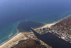
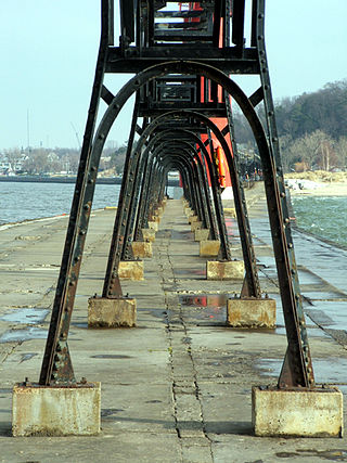
Frankfort is a city in Benzie County in the U.S. state of Michigan. The population was 1,286 at the 2010 census. The elevation of Frankfort is 600 ft (183 m) above sea level. The city is situated with Lake Michigan to the west, Lake Betsie, formed by the Betsie River before flowing into Lake Michigan, on the south and Crystal Lake Township to the north and east. The city is on M-22 just north of Elberta. M-115 has its western terminus in the city. The Frankfort North Breakwater Lighthouse is at the end of the northern breakwater in Lake Michigan.

<span class="mw-page-title-main">Frankfort Light</span> Lighthouse in Michigan, United States

The Frankfort Light is a lighthouse located on the north breakwater in the harbor in Frankfort, Michigan. The current light was constructed in 1912 and placed on the National Register of Historic Places in 2005.

<span class="mw-page-title-main">Charlevoix South Pier Light Station</span> Lighthouse in Michigan, United States

The Charlevoix South Pier Light Station is located on Lake Michigan at the entrance to Lake Charlevoix in Charlevoix County in the U.S. state of Michigan at the end of the south pier/breakwater of the channel leading to Round Lake in the city of Charlevoix.

<span class="mw-page-title-main">Milwaukee Breakwater Light</span> Lighthouse

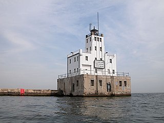
The Milwaukee Breakwater lighthouse was built in 1926 in the harbor of Milwaukee in Milwaukee County, Wisconsin to mark the entrance to the harbor. One of the last fully enclosed breakwater lighthouses in the Great Lakes, the structure was placed on the National Register of Historic Places in 2011.

<span class="mw-page-title-main">Manistique East Breakwater Light</span> Lighthouse in Michigan, United States

The Manistique East Breakwater Light is a lighthouse is located in the harbor of Manistique, Michigan. It was listed on the National Register of Historic Places in 2005.

<span class="mw-page-title-main">Menominee Pier Light</span> Lighthouse in Michigan, United States

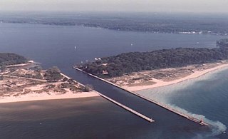
The Menominee North Pier lighthouse is located in the harbor of Menominee, Michigan. The station was first lit in 1877. The current structure and its still operational light was lit in 1927, and automated in 1972. It is also sometimes called the "Menominee (Marinette) North Pierhead Light".

<span class="mw-page-title-main">Harbor Beach Light</span> Lighthouse in Michigan, United States

The Harbor Beach Lighthouse is a "sparkplug lighthouse" located at the end of the north breakwall entrance to the harbor of refuge on Lake Huron. The breakwall and light were created by the United States Army Corps of Engineers to protect the harbor of Harbor Beach, Michigan, which is the largest man-made freshwater harbor in the world. Harbor Beach is located on the eastern edge of the Thumb of Huron County, in the state of Michigan.

<span class="mw-page-title-main">Marquette Harbor Light</span> Lighthouse in Michigan, United States

The Marquette Harbor Light is located on Lake Superior in Marquette, Michigan, a part of the Upper Peninsula. It is an active aid to navigation.

<span class="mw-page-title-main">New Canal Light</span> Lighthouse in Louisiana, US

The New Canal Light or was first established in 1838 at the north end of the New Basin Canal which ran from Lake Pontchartrain to the Uptown or "American" section of the city which today is known as the New Orleans Central Business District. The canal was filled in about 1950, but the lighthouse remained on a jetty extending into the lake on a half mile long stretch of the canal that was left and is still used as a small boat and yachting harbor.

<span class="mw-page-title-main">Ontonagon Harbor Piers Historic District</span> Historic district in Michigan, United States

The Ontonagon Harbor Piers Historic District is historic shipping structure located on the Ontonagon River at Lake Superior in Ontonagon, Michigan. It was listed on the National Register of Historic Places in 2001.

<span class="mw-page-title-main">Grand Marais Harbor of Refuge Inner and Outer Lights</span> Lighthouses in Michigan, United States

The Grand Marais Harbor of Refuge Inner and Outer Lights are a pair of lighthouses located on the west pier at the entry to Grand Marais Harbor of Refuge, in Grand Marais, Michigan. They were listed on the National Register of Historic Places in 2012.

<span class="mw-page-title-main">Navigation Structures at Pentwater Harbor</span> Navigation structures in Michigan, United States

The Navigation Structures at Pentwater Harbor are navigational structures located at the west end of Lowell Street in Pentwater, Michigan. They were listed on the National Register of Historic Places in 2001.

<span class="mw-page-title-main">Keweenaw Waterway Lower Entrance Light</span> Lighthouse in Michigan, United States

The Keweenaw Waterway Lower Entrance Light, also known as the Portage Entry Light, is a lighthouse located at the south end of breakwater at mouth of the Portage River in Torch Lake Township. It was listed on the National Register of Historic Places in 2014.

<span class="mw-page-title-main">Keweenaw Waterway Upper Entrance Light</span> Lighthouse in Michigan, United States

The Keweenaw Waterway Upper Entrance Light is a lighthouse located at the north end of the Portage River in McLain State Park in Hancock Township, Michigan. It was listed on the National Register of Historic Places in 2014.

<span class="mw-page-title-main">Presque Isle Harbor Breakwater Light</span> Lighthouse in Michigan, United States

The Presque Isle Harbor Breakwater Light is a lighthouse located on the breakwater at northeast side of Presque Isle Harbor in Marquette, Michigan. It was listed on the National Register of Historic Places in 2016.

<span class="mw-page-title-main">Navigation Structures at Saugatuck Harbor</span> Navigation structures in Michigan, United States

The Navigation Structures at Saugatuck Harbor consist of two piers flanking the mouth of the Kalamazoo River on the shore of Lake Michigan near Saugatuck, Michigan. The structures were listed on the National Register of Historic Places in 2001.

<span class="mw-page-title-main">Manistee Harbor, South Breakwater</span> United States historic place

The Manistee Harbor, South Breakwater is a navigational structure located at the mouth of the Manistee River, in Manistee, Michigan. It was listed on the National Register of Historic Places in 1995. The breakwater is significant due to its construction, which represents a final stage in the United States Army Corps of Engineers's use of timber crib substructures in pier and breakwater construction.

<span class="mw-page-title-main">Navigation Structures at White Lake Harbor</span> Navigation structures in Michigan, United States

The Navigation Structures at White Lake Harbor area set of piers protecting the channel connecting Lake Michigan and White Lake, located at the end of Lau Road near Whitehall, Michigan. It was listed on the National Register of Historic Places in 2000.

<span class="mw-page-title-main">Piers and Revetments at Grand Haven, Michigan</span> United States historic place

The Piers and Revetments at Grand Haven, Michigan are navigational structures located at the mouth of the Grand River in Grand Haven, Michigan. The structures were listed on the National Register of Historic Places in 1995.

<span class="mw-page-title-main">Navigation Structures at Harbor Beach Harbor</span> Navigation structures in Michigan, United States

The Navigation Structures at Harbor Beach Harbor are a series of breakwaters located in Lake Huron, on North Lakeshore Drive in Harbor Beach, Michigan. They were listed on the National Register of Historic Places in 1997.

References

  1. 1 2 "National Register Information System". National Register of Historic Places . National Park Service. July 9, 2010.
  2. 1 2 3 Terry Pepper. "Frankfort North Breakwater Light". Seeing the Light. Retrieved January 1, 2014.
  3. 1 2 3 4 Robert R. Bottin Jr (June 1988), Case Histories of Corps Breakwater and Jetty Structures : Report 3, North Central Division (PDF), US Army Corps of Engineers, pp. 243–248
  4. "Frankfort North Breakwater, MI". Lighthouse Friends. Retrieved January 2, 2014.
  5. "Frankfort Harbor, MI". US Army Corps of Engineers, Detroit District. Retrieved January 2, 2014.

Further reading