Negomano

Last updated
Negomano
Mozambique adm location map.svg
Red pog.svg
Negomano
Coordinates: 11°25′42″S38°29′32″E / 11.42833°S 38.49222°E / -11.42833; 38.49222
Country Flag of Mozambique.svg  Mozambique
Provinces Cabo Delgado Province
District Mueda District

Negomano or Ngomano is a village in northern Mozambique, in Cabo Delgado Province. It is located on the border with Tanzania on the confluence of the Ruvuma River and the Lugenda River. [1]

Contents

Negomano was the scene of fierce battle between the German Army and the Portuguese Army during World War I, in November/December 1917 when several hundred soldiers were killed (battle of Ngomano).

Development initiatives launched subsequent to civil war of 1992 has resulted in economic progress in Negomano, which is part of the Niassa Reserve. Further, a four country initiative of Malawi, Mozambique, the northern and eastern provinces of Zambia, and the southern regions of the United Republic of Tanzania) has resulted in the creation of the 720 metres (2,360 ft) long Unity Bridge across the Ruvuma River at Negomano.

History

The Negomano area was occupied during the Early Iron Age by early hunter-gatherers. Modern tribes in the area can be traced to the southern shores of Lake Malawi who moved into the Rovuma River valley in the medieval period to escape severe drought. [2]

Due to its strategical location, a military post was located at Negomano, which was in contact with the town of Meculu. [3] During the Portuguese occupation, two expatriate officers were located in Negomano district to ensure that the local farmers met their quota of cotton production and complied with the standards set by the senior bureaucrats in the capital, Lourenco Marques (Maputo). [4]

Germans who had colonial designs on Mozambique, particularly its northern region, by diplomatic coercion had obtained border concessions from Portugal by annexing the mouth of the Rovuma River and even established their commune at Quionga. This ambition got a boost during the World War I when they launched a full-scale war on Mozambique, which resulted in Portuguese getting defeated initially. However, with great investment of manpower and material, the Germans could be eventually defeated by the British and the Portuguese Army. [5]

A battle took place at Negomano on November 25, 1917, between the Germans and the Portuguese during World War I. In the river valley and the Nissa Wild Life Preserve enclosed within it, German Army supported by Askaris, under the command of General Paul Erich von Lettow-Vorbeck, crossed the Ruvuma River at Negomano and entered the Portuguese held Mozambique in search of food for his troops. In December 1917, after crossing the river, the general with his army marched south along the Lugenda River and arrived at Metarica. One of the battalions dispatched towards the Mecula Mountain in search of food had to fight a fierce battle with the Portuguese who were led by Major João Teixeira Pinto. The Portuguese force was comprehensively defeated. Witness to this battle are seen in the form of a few graves on the hill slopes at Mecula, the district capital of Niassa. [6] [7] The Germans defeated a Portuguese force of some 1200 men at Negomano and seized valuable supplies, including 250,000 rounds, six machine guns and medicine. [8] During this battle known as "Battle of Negomano", following the defeat of Portuguese Army by the German Army, 550 soldiers were taken prisoners. [9]

Negomano was occupied during the war in 1976 when a mine exploded 10 kilometres (6.2 mi) from the village. [10] Two soldiers were seriously wounded and had to be flown out by helicopter.

Ethnicity and culture

The Makonde ethnic tribe is the dominant tribal group residing in the Cabo Delgado Province where Negomano is a village. Mekondes’ have a strong and unique culture with an innate talent for wood and ivory carving. Ancestral customs of ritual tattooing and teeth filing are still practiced by them. [11]

The historical Namachakole trench (Lilondo suburb) where the tombs of 11 Frelimo fighters killed in combat at Negomano are buried is a tourist attraction in Mueda district. The other attraction is of wild life safaris originating from Negomano. [11]

Ecology and community development

Following the end of civil war in 1992 in Mozambique, community conservation initiatives were launched involving local communities, NGOs, and private sector. One such initiative instituted by the Government of Mozambique was specific to the Niassa Reserve titled the “Niassa Reserve Community-Based Natural Resources Management (CBNRM),” which covered three villages within the reserve namely, Negomano, Mussoma and Naulala. Investment funds and expertise required over the period of project implementation were provided under a memorandum of understanding (MoU) signed in 2001 between the Sociedade para Gestão e Desenvolvimento da Reserva do Niassa (SGDRN) and WWF Southern Africa Regional Office (SARPO). The Norwegian Agency for Development and Cooperation (NORAD) funded the project, which was implemented by WWF Norway and the WWF SARPO, through WWF Mozambique in association with SGDRN, over the period from 2001 to 2005. This project has been reportedly assessed as successful in achieving the framework of defined objectives. The achievements reported are: Establishing community-based organizations; addressing the animal human conflicts issues through training and evolving suitable techniques for reducing such conflicts; creating better knowledge base to the staff operating the programmes with due regard to community sensitivities, develop income generating initiatives such as establishing honey and fishing user groups; appraising the community of the stated objectives of the project and creating a trust between the community and the administrators of the reserve. [12]

Transport

When David Livingstone had visited the area in 1858 it had ended his hopes of building a highway. [1] However, a bridge, known as Unity Bridge has been built in the vicinity connecting Mozambique to Tanzania across the river Mourama. It is one of the development projects planned under the Mtwara Corridor Spatial Development Initiative. [13]

This project titled “A new development corridor” as a four country initiative (to benefit Malawi, Mozambique, the northern and eastern provinces of Zambia, and the southern regions of the United Republic of Tanzania) in the heart of the Southern African Development Community (SADC) was launched in 2004 signed under a legal framework that should make the Mtwara Development Corridor a reality and improve the lives of the people who live in these four countries. [13] [14]

The initiative to build this bridge, across the Ruvuma River at Negomano, also known as the "Unity Bridge 1" began in 1975. However, a formal agreement between Tanzania and Mozambique was signed on October 10, 2005. [14] The bridge, as designed by Norconsult, 750 m long, was finally completed in 2010. It was formally inaugurated on May 12, 2010, by the presidents of Mozambique and Tanzania. This bridge will be a forerunner for the projects planned under the Mtwara Corridor. It also reduces the distance along the Cape to Cairo Road. [14]

The main place of entry into Negomano on the Mozambique side is via a dirt road to the south east, which connects to the nearest major town of Mueda, which is linked by air via Mueda Airport. The town of Lugenda is located down river to the southwest of Negomano. Negomano reportedly has one school of about 100 children and a small hospital. [4]

Related Research Articles

Niassa Province Province of Mozambique

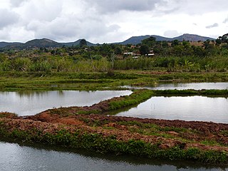
Niassa is a province of Mozambique. It has an area of 129,056 km2 and a population of 1,810,794 (2017). It is the most sparsely populated province in the country. Lichinga is the capital of the province. There are a minimum estimated 450,000 Yao people living in Mozambique. They largely occupy the eastern and northern part of the Niassa province and form about 40% of the population of Lichinga, the capital of this province.

Ruvuma Region Region of Tanzania

Ruvuma Region is one of Tanzania's 31 administrative regions. The regional capital is the municipality of Songea. According to the 2012 national census, the region had a population of 1,376,891, which was lower than the pre-census projection of 1,449,830. For 2002–2012, the region's 2.1 percent average annual population growth rate was the twentieth highest in the country. It was also the 28th most densely populated region with 22 inhabitants per square kilometre (57/sq mi).

Mueda District District in Cabo Delgado Province, Mozambique

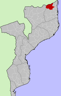
Mueda is a district of the province of Cabo Delgado, in Moçambique. The capital is the town of Mueda.

Songea Place in Ruvuma, Tanzania

Songea is the capital of Ruvuma Region in southwestern Tanzania. It is located along the A19 road. The city has a population of approximately 203,309, and it is the seat of the Roman Catholic Archdiocese of Songea. Between 1905 and 1907, the city was a centre of African resistance during the Maji Maji Rebellion in German East Africa. The city is poised to experience significant economic growth in the near future as the Mtwara Corridor opens up in a few years. Projected to be the sixth fastest growing city on the African continent between 2020 and 2025, with a 5.74% growth.

Ruvuma River

Ruvuma River, formerly also known as the Rovuma River, is a river in the African Great Lakes region. During the greater part of its course, it forms the border between Tanzania and Mozambique. The river is 800 kilometres (497 mi) long, with a drainage basin of 155,500 square kilometres (60,000 sq mi) in size. Its mean annual discharge is 475 m³/s at its mouth.

Yao people (East Africa)

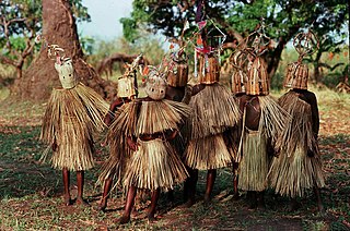
The Yao people, waYao, are a major Bantu ethnic and linguistic group based at the southern end of Lake Malawi, who played an important part in the history of Southeast Africa during the 19th century. The Yao are a predominantly Muslim people of about 2 million spread over three countries, Malawi, northern Mozambique, and in Ruvuma Region and Mtwara Region of Tanzania. The Yao people have a strong cultural identity, which transcends the national borders.

Niassa Company

The Niassa Company or Nyassa Chartered Company was a royal company in the Portuguese colony of Mozambique, then known as Portuguese East Africa, that had the concession of the lands that include the present provinces of Cabo Delgado and Niassa between 1891 and 1929.

Those interested in the subject can monitor changes to the pages by clicking on Related changes in the sidebar. Articles related to Tanzania include:

Yao is a Bantu language in Africa with approximately two million speakers in Malawi, and half a million each in Tanzania and Mozambique. There are also some speakers in Zambia. In Malawi, the main dialect is Mangochi, mostly spoken around Lake Malawi. In Mozambique, the main dialects are Makale and Massaninga. The language has also gone by several other names in English, including chiYao or ciYao, Achawa, Adsawa, Adsoa, Ajawa, Ayawa, Ayo, Ayao, Djao, Haiao, Hiao, Hyao, Jao, Veiao, and waJao.

Unity Bridge

The Unity Bridge across Ruvuma River at Negomano, Mozambique, between Tanzania and Mozambique, was proposed as early as 1975, shortly after Mozambique's independence. It was the idea of the two countries' former Presidents, Mwalimu Nyerere and Samora Machel. Several design studies and limited construction work were completed in the early 1980s, but the Unity Bridge was not finished due to lack of funds.

Niassa Reserve

Niassa Reserve is a nature reserve in Cabo Delgado Province and Niassa Province, Mozambique. Covering over 42,000 square kilometres, it is the largest protected area in the country. The reserve is part of the Trans-Frontier Conservation Area and links to the Tanzanian Lukwika-Lumesule Game Reserve. It will connect to the Lake Niassa Reserve when it is completed.

Outline of Tanzania Overview of and topical guide to Tanzania

The following outline is provided as an overview of and topical guide to Tanzania:

Battle of Ngomano 1917 battle in the East African Campaign of WWI

The Battle of Ngomano or Negomano was fought between Germany and Portugal during the East African Campaign of World War I. A force of Germans and Askaris under Paul Emil von Lettow-Vorbeck had recently won a costly victory against the British at the Battle of Mahiwa, in present-day Tanzania and ran very short of food and other supplies. As a consequence, the Germans invaded Portuguese East Africa to the south, both to supply themselves with captured Portuguese materiel and escape superior British forces to the north.

Lugenda River

The Lugenda or Lujenda is a river of northern Mozambique. It flows in a south-north direction from Lake Amaramba/Lake Chiuta and is the largest tributary of the Ruvuma River. It joins the Luambala River at 13°26′12″S36°18′20″E. The river valley is reported to be only 800 feet (240 m) above sea level. North of Lake Chiuta, those on the west bank call it the Msambiti River. At one point, the Lugenda splits into several streams with islands between them, some of whom are populated such as the island Achemponda.

Lake Amaramba

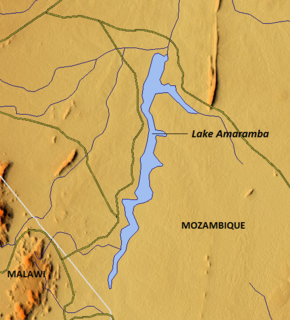
Lake Amaramba is a shallow lake in Mozambique, near the border with Malawi. Located in the Nyasa plateau, it is north of Lake Chiuta. The lakes are separated by a sandy ridge and a channel links the two lakes. On the western side of the channel, the connecting waterway is known as the River Msambiti while on the eastern side, it is known as the Lugenda River. Lake Amaramba is intermittently linked to the Lugenda River, a tributary of the Ruvuma River.

Mtwara–Mbamba Bay Road Road in Tanzania

The Mtwara–Mbamba Bay Road, also A19 Road, connects the city of Mtwara on the Indian Ocean coast, to the town of Mbamba Bay on the eastern coast of Lake Malawi. It is a busy and important transport corridor in the southern regions of Tanzania. It is also an integral part of the Mtwara Development Corridor that spans four Southern African countries; Malawi, Mozambique, Tanzania and Zambia.

Mtwara Development Corridor

The Mtwara Development Project is a major infrastructure development project involving southern Tanzania, northern Mozambique, eastern Malawi and Eastern Zambia. The goal of this project is to provide road, rail and waterway access from the surrounding region to the Port of Mtwara. The region and the corridor has been neglected by the respective governments for over 40 years and the recent discovery of oil, gas and various minerals has kick started the development of the project. A road and rail link is to be built from the port of Mtwara to Mbamba Bay on Lake Nyasa to link Malawi to the corridor and further road links into Mozambique will facilitate access to northern Mozambique.

Mozambique–Tanzania relations Bilateral relations

Tanzania–Mozambique relations are bilateral relations between Tanzania and Mozambique.

Njesi Highlands Mountain range in Mozambique

The Njesi Highlands are a range of mountains in northern Mozambique.

Mount Mecula

Mount Mecula is a mountain in northern Mozambique. It is located in Niassa Province, near the center of Niassa National Reserve.

References

  1. 1 2 Stark, Peter (2005). At the mercy of the river: an exploration of the last African wilderness. Ballantine Books. p. 295. ISBN   0-345-44181-8.
  2. The African archaeological review, Volume 16. Cambridge University Press. 1999. pp. 124–131.
  3. African music, Volume 3. African Music Society (South Africa), International Library of African Music. 1962. p. 79.
  4. 1 2 Barton, Donald (2004). An Affair With Africa. Authors On Line Ltd. p. 139. ISBN   0-7552-0122-1.
  5. Cann J.P. "Mozambique, German East Africa and the Great War".Cite journal requires |journal= (help)
  6. "Emerging from the shadows, Nissa National Reserve" (PDF). Africa Geographic Article. June 2007. Archived from the original (PDF) on 2011-07-14. Retrieved 2010-10-11.
  7. Moreira dos Santos, Ernesto (1961). Combate de Negomano (cobiça de Moçambique), seus heróis e seus inimigos: memórias (2 ed.). p. 140.
  8. Woodward, David R. (2009). World War I Almanac. Infobase Publishing. p. 264. ISBN   978-0-8160-7134-0.
  9. "Portugal History". Republican Period 1910-1917. Portugal infonet. Retrieved 2010-10-12.
  10. Coccia, Giancarlo (1976). The scorpion sting: Moçambique. Moderna, Livaria. p. 111.
  11. 1 2 "The Provinces". High Commission of the Republic of Mozambique to the United Kingdom of Great retain and Northern Ireland. Retrieved 2010-10-12., mirror site
  12. "Niassa Reserve Co-Management". WWF. Retrieved 2010-10-12.
  13. 1 2 "Four countries, one people, one development corridor – Mtwara". The Southern African Development Community Today. Archived from the original on 2005-04-28. Retrieved 2010-10-12.
  14. 1 2 3 "Unity Bridge". iScanMyFood.com. Archived from the original on 2011-07-27. Retrieved 2010-10-12.