Nekoma, North Dakota

Last updated

Nekoma, North Dakota
Grain Elevator in Nekoma, North Dakota 7-19-2009.jpg
Grain Elevator in Nekoma
ND Cavalier County Nekoma.svg
Location of Nekoma, North Dakota
Coordinates: 48°34′35″N98°22′16″W / 48.57639°N 98.37111°W / 48.57639; -98.37111
CountryUnited States
State North Dakota
County Cavalier
Founded1905
Area
[1]
  Total0.37 sq mi (0.97 km2)
  Land0.37 sq mi (0.96 km2)
  Water0.00 sq mi (0.00 km2)
Elevation
[2]
1,621 ft (494 m)
Population
 (2020)
  Total31
  Density83.33/sq mi (32.19/km2)
Time zone UTC-6 (CST)
  Summer (DST) UTC-5 (CDT)
ZIP code
58355
Area code 701
FIPS code 38-55740
GNIS feature ID1036177 [2]

Nekoma is a tiny rural village in Cavalier County, North Dakota, United States. The population was 31 at the 2020 census. [3] There is a large grain elevator, a bar and two churches, plus homes at Nekoma, and an agricultural service just outside the village boundary. Nekoma was founded in 1905 and is 15 miles south of Langdon.

Contents

Of particular interest in Nekoma is the Stanley R. Mickelsen Safeguard Complex, with a large pyramid phased array radar structure visible for miles in every direction.

Geography

According to the United States Census Bureau, the city has a total area of 0.36 square miles (0.93 km2), all land. [4]

Demographics

Historical population
CensusPop.Note
1910 120
1920 18957.5%
1930 1911.1%
1940 184−3.7%
1950 140−23.9%
1960 1432.1%
1970 84−41.3%
1980 10221.4%
1990 63−38.2%
2000 51−19.0%
2010 50−2.0%
2020 31−38.0%
2021 (est.)28 [5] −9.7%
U.S. Decennial Census [6]
2020 Census [3]

2010 census

As of the census of 2010, there were 50 people, 21 households, and 15 families residing in the city. The population density was 138.9 inhabitants per square mile (53.6/km2). There were 36 housing units at an average density of 100.0 per square mile (38.6/km2). The racial makeup of the city was 100.0% White.

There were 21 households, of which 19.0% had children under the age of 18 living with them, 57.1% were married couples living together, 4.8% had a female householder with no husband present, 9.5% had a male householder with no wife present, and 28.6% were non-families. 28.6% of all households were made up of individuals, and 9.6% had someone living alone who was 65 years of age or older. The average household size was 2.38 and the average family size was 2.93.

The median age in the city was 54 years. 22% of residents were under the age of 18; 2% were between the ages of 18 and 24; 12% were from 25 to 44; 50% were from 45 to 64; and 14% were 65 years of age or older. The gender makeup of the city was 58.0% male and 42.0% female.

2000 census

As of the census of 2000, there were 51 people, 21 households, and 12 families residing in the city. The population density was 136.7 inhabitants per square mile (52.8/km2). There were 41 housing units at an average density of 109.9 per square mile (42.4/km2). The racial makeup of the city was 98.04% White, and 1.96% from two or more races.

There were 21 households, out of which 38.1% had children under the age of 18 living with them, 52.4% were married couples living together, and 38.1% were non-families. 38.1% of all households were made up of individuals, and 23.8% had someone living alone who was 65 years of age or older. The average household size was 2.43 and the average family size was 3.31.

In the city, the population was spread out, with 29.4% under the age of 18, 3.9% from 18 to 24, 23.5% from 25 to 44, 29.4% from 45 to 64, and 13.7% who were 65 years of age or older. The median age was 44 years. For every 100 females, there were 112.5 males. For every 100 females age 18 and over, there were 125.0 males.

The median income for a household in the city was $27,188, and the median income for a family was $34,375. Males had a median income of $28,750 versus $11,250 for females. The per capita income for the city was $13,330. There were no families and 5.4% of the population living below the poverty line, including no under eighteens and 22.2% of those over 64.

Related Research Articles

<span class="mw-page-title-main">Rembrandt, Iowa</span> City in Iowa, United States

Rembrandt is a city in Buena Vista County, Iowa, United States. The population was 209 at the time of the 2020 census.

<span class="mw-page-title-main">Hayesville, Iowa</span> City in Iowa, United States

Hayesville is a city in Keokuk County, Iowa, United States. The population was 41 at the time of the 2020 census.

<span class="mw-page-title-main">Whittemore, Iowa</span> City in Iowa, United States

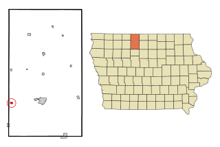
Whittemore is a city in Kossuth County, Iowa, United States. The population was 497 at the time of the 2020 census.

<span class="mw-page-title-main">New Liberty, Iowa</span> City in Iowa, USA

New Liberty is a city in Scott County, Iowa, United States. The population was 138 at the time of the 2020 census.

<span class="mw-page-title-main">Harris, Kansas</span> Unincorporated community in Anderson County, Kansas

Harris is an unincorporated community in Anderson County, Kansas, United States. As of the 2020 census, the population of the community and nearby areas was 47.

<span class="mw-page-title-main">Woodland Hills, Kentucky</span> City in Kentucky, United States

Woodland Hills is a home rule-class city in Jefferson County, Kentucky, United States. The population was 696 at the 2010 census.

<span class="mw-page-title-main">Olivet, Michigan</span> City in Michigan, United States

Olivet is a city in Eaton County in the U.S. state of Michigan. The population was 1,605 at the 2010 census. Olivet College is located in the city.

<span class="mw-page-title-main">Backus, Minnesota</span> City in Minnesota, United States

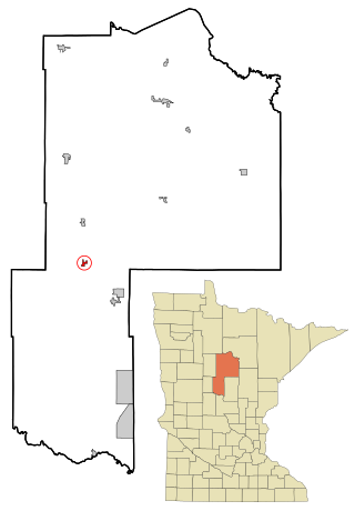
Backus is a city in Cass County, Minnesota, United States. The population was 250 at the 2010 census. It is part of the Brainerd Micropolitan Statistical Area.

<span class="mw-page-title-main">Watkins, Minnesota</span> City in Minnesota, United States

Watkins is a city in Meeker County, Minnesota, United States. The population was 962 at the 2010 census.

<span class="mw-page-title-main">Henning, Minnesota</span> City in Minnesota, United States

Henning is a city in Otter Tail County, Minnesota, United States. The population was 854 at the 2020 census.

<span class="mw-page-title-main">Brookston, Minnesota</span> City in Minnesota, United States

Brookston is a city in Saint Louis County, Minnesota, United States; located along the Saint Louis River, opposite the mouth of the Artichoke River. The population was 118 at the 2020 census.

<span class="mw-page-title-main">Waldorf, Minnesota</span> City in Minnesota, United States

Waldorf is a city in Waseca County, Minnesota, United States. The population was 229 at the 2010 census.

<span class="mw-page-title-main">St. Martins, Missouri</span> City in Missouri, United States

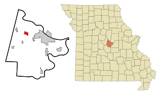
St. Martins or Saint Martins is a city in Cole County, Missouri, United States. The population was 1,191 at the 2020 census. It is part of the Jefferson City, Missouri Metropolitan Statistical Area.

<span class="mw-page-title-main">Pattonsburg, Missouri</span> City in Missouri, United States

Pattonsburg is a city in northwest Daviess County, Missouri, United States. The population was 314 at the 2020 census.

<span class="mw-page-title-main">Deepwater, Missouri</span> City in Missouri, United States

Deepwater is a city in Henry County, Missouri, United States. The population was 433 at the 2010 census.

<span class="mw-page-title-main">Strandquist, Minnesota</span> City in Minnesota, United States

Strandquist is a city in Lincoln Township of Marshall County, Minnesota, United States. The population was 70 at the 2020 census.

<span class="mw-page-title-main">Kramer, North Dakota</span> City in North Dakota, United States

Kramer is a city in Bottineau County, North Dakota, United States. The population was 24 at the 2020 census. Kramer was founded in 1905.

<span class="mw-page-title-main">Perth, North Dakota</span> City in North Dakota, United States

Perth is a city in Towner County, North Dakota, United States. The population was 6 at the 2020 census. Perth was founded in 1897. It is not to be confused with Perth, Scotland or Perth, Western Australia.

<span class="mw-page-title-main">Rittman, Ohio</span> City in Ohio, United States

Rittman is a city in Medina and Wayne counties in the U.S. state of Ohio. All but a small portion of the city is in Wayne County, within commuting distance of Akron, Canton and Cleveland. The population was 6,131 at the 2020 census.

<span class="mw-page-title-main">Black Earth, Wisconsin</span> Village in Wisconsin, United States

Black Earth is a village in Dane County, Wisconsin, United States. The population was 1,338 at the 2010 census. The village is located within the Town of Black Earth. It is part of the Madison Metropolitan Statistical Area.

References

  1. "ArcGIS REST Services Directory". United States Census Bureau. Retrieved September 20, 2022.
  2. 1 2 U.S. Geological Survey Geographic Names Information System: Nekoma, North Dakota
  3. 1 2 "Explore Census Data". United States Census Bureau . Retrieved June 16, 2022.
  4. "US Gazetteer files 2010". United States Census Bureau. Archived from the original on January 25, 2012. Retrieved June 14, 2012.
  5. "City and Town Population Totals: 2020-2021". United States Census Bureau. July 12, 2022. Retrieved July 12, 2022.
  6. United States Census Bureau. "Census of Population and Housing" . Retrieved August 30, 2013.