New Berlin, New York

Last updated

New Berlin, New York
St. Andrew's Episcopal Church New Berlin NY May 09.jpg
St. Andrew's Episcopal Church, New Berlin
Chenango County NY New Berlin town highlighted.svg
USA New York location map.svg
Red pog.svg
New
Berlin
Coordinates: 42°35′27″N75°23′38″W / 42.59083°N 75.39389°W / 42.59083; -75.39389
Country United States
State New York
County Chenango
Government
  Type Town Council
   Town Supervisor Robert Starr(Open Door)
   Town Council
Members' List
Area
[1]
  Total46.57 sq mi (120.62 km2)
  Land46.13 sq mi (119.49 km2)
  Water0.44 sq mi (1.14 km2)
Elevation
1,320 ft (400 m)
Population
 (2010)
  Total2,682
  Estimate 
(2016) [2]
2,510
  Density55.10/sq mi (21.27/km2)
Time zone Eastern (EST)
ZIP code
13411
FIPS code 36-017-49957
Website www.townofnewberlin.org

New Berlin is a town in Chenango County, central New York, United States. The population was 2,682 at the 2010 census. [3] The town contains the village of New Berlin. The town is at the eastern border of the county and is northeast of Norwich.

Contents

History

The first European-American settlers arrived c.1790, after the American Revolutionary War. This followed the Iroquois League nations being forced to cede most of their territory to the United States following the defeat of their ally Great Britain. The Mohawk and other Iroquois nations moved to Ontario, Canada, where they were granted some land by the British Crown in compensation. Some small reservations were set up for them in New York state.

The Town of New Berlin was founded by a partition of the Town of Norwich in 1807; it was named after Berlin, Germany, from which many new settlers had come. In 1821 the town changed its name to "Lancaster", but returned to "New Berlin" the next year. In 1853, part of the town was used to form the Town of Sherburne.

Geography

According to the United States Census Bureau, the town of New Berlin has a total area of 46.6 square miles (120.6 km2), of which 46.1 square miles (119.5 km2) is land and 0.42 square miles (1.1 km2), or 0.94%, is water. [3]

The eastern town line, marked by the Unadilla River, is the border of Otsego County. The Unadilla is a southward-flowing tributary of the Susquehanna River.

New York State Route 8, a north-south highway, intersects New York State Route 80 north of New Berlin village at Five Corners. New York State Route 23 is an east-west highway running east from Norwich.

Demographics

Historical population
CensusPop.Note
1820 2,366
1830 2,64311.7%
1840 3,08616.8%
1850 2,562−17.0%
1860 2,6172.1%
1870 2,460−6.0%
1880 2,5724.6%
1890 2,427−5.6%
1900 2,5254.0%
1910 2,328−7.8%
1920 2,104−9.6%
1930 2,1230.9%
1940 2,112−0.5%
1950 2,35911.7%
1960 2,63311.6%
1970 2,8237.2%
1980 3,0257.2%
1990 3,0460.7%
2000 2,803−8.0%
2010 2,682−4.3%
2019 (est.)2,510 [4] −6.4%
U.S. Decennial Census [5]

As of the census [6] of 2000, there were 2,803 people, 1,083 households, and 737 families residing in the town. The population density was 60.4 inhabitants per square mile (23.3/km2). There were 1,358 housing units at an average density of 29.3 per square mile (11.3/km2). The racial makeup of the town was 98.14% White, 0.36% Black or African American, 0.14% Native American, 0.14% Asian, 0.04% Pacific Islander, 0.25% from other races, and 0.93% from two or more races. Hispanic or Latino of any race were 1.21% of the population.

There were 1,083 households, out of which 32.0% had children under the age of 18 living with them, 55.3% were married couples living together, 9.1% had a female householder with no husband present, and 31.9% were non-families. 26.4% of all households were made up of individuals, and 13.8% had someone living alone who was 65 years of age or older. The average household size was 2.51 and the average family size was 2.96.

In the town, the population was spread out, with 25.6% under the age of 18, 5.6% from 18 to 24, 26.5% from 25 to 44, 25.4% from 45 to 64, and 17.0% who were 65 years of age or older. The median age was 40 years. For every 100 females, there were 89.6 males. For every 100 females age 18 and over, there were 86.9 males.

The median income for a household in the town was $31,875, and the median income for a family was $40,000. Males had a median income of $27,411 versus $21,348 for females. The per capita income for the town was $16,546. About 10.5% of families and 16.1% of the population were below the poverty line, including 23.8% of those under age 18 and 10.6% of those age 65 or over.

Communities and locations in the town

Notable people

Education

Related Research Articles

<span class="mw-page-title-main">Chenango County, New York</span> County in New York, United States

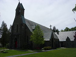
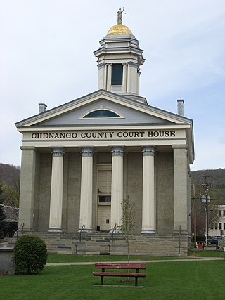
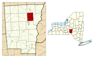
Chenango County is a county located in the south-central section U.S. state of New York. As of the 2020 census, the population was 47,220. Its county seat is Norwich. The county's name originates from an Oneida word meaning 'large bull-thistle'. The county is part of the Southern Tier region of the state.

<span class="mw-page-title-main">Columbus, New York</span> Town in New York, United States

Columbus is a town in Chenango County, New York, United States. The population was 975 at the 2010 census. Columbus is in the northeastern corner of the county and is northeast of Norwich.

<span class="mw-page-title-main">Guilford, New York</span> Town in New York, United States

Guilford is a town in Chenango County, New York, United States. The town is on the eastern border of the county. The population was 2,922 at the 2010 census.

<span class="mw-page-title-main">McDonough, New York</span> Town in New York, United States

McDonough is a town in Chenango County, New York, United States. The population was 886 at the 2010 census. The town is named after Thomas Macdonough, a naval officer who served on Lake Champlain and other locations. McDonough is located in the western part of Chenango County, west of Norwich.

<span class="mw-page-title-main">North Norwich, New York</span> Town in New York, United States

North Norwich is a town in Chenango County, New York, United States. The population was 1,783 at the 2010 census. The town is directly north of the City of Norwich in the eastern half of the county.

<span class="mw-page-title-main">Pharsalia, New York</span> Town in New York, United States

Pharsalia is a town in Chenango County, New York, United States. The population was 593 at the 2010 census. The town was named after Pharsalia, which is a commonly accepted name of the decisive battle in the Great Roman Civil War, where Julius Caesar defeated Pompey in 48 BCE.

<span class="mw-page-title-main">Plymouth, New York</span> Town in New York, United States

Plymouth is a town in Chenango County, New York, United States. The population was 1,804 at the 2010 census. It is an interior town in the northern part of the county. The town is northwest of the city of Norwich. Plymouth was also known as Plymouth Rock.

<span class="mw-page-title-main">Preston, New York</span> Town in New York, United States

Preston is a town in Chenango County, New York, United States. The population was 1,044 at the 2010 census. Preston is an interior town of Chenango County and is west of the city of Norwich.

<span class="mw-page-title-main">Smithville, New York</span> Town in New York, United States

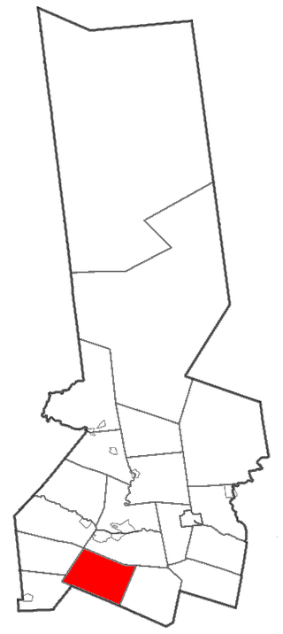
Smithville is a town in Chenango County, New York, United States. The population was 1,330 at the 2010 census. The town is at the western border of Chenango County, west of the city of Norwich.

<span class="mw-page-title-main">Columbia, New York</span> Town in New York, United States

Columbia is a town in Herkimer County, New York, United States. As of the 2020 census, the town population was 1,569. The town is at the southern border of the county and is southeast of Utica.

<span class="mw-page-title-main">Sangerfield, New York</span> Town in New York, United States

Sangerfield is a town in Oneida County, New York, United States. The population was 2,561 at the 2010 census. The town is named after Jedediah Sanger, an early settler.

<span class="mw-page-title-main">Butternuts, New York</span> Town in New York, United States

Butternuts is a town located in Otsego County, New York, United States. As of the 2010 census, the town had a population of 1,786. The Town of Butternuts is located in the southwestern part of the county, and is west of Oneonta.

<span class="mw-page-title-main">Edmeston, New York</span> Town in New York, United States

Edmeston is a town located in Otsego County, New York, United States. As of the 2010 census, the town had a total population of 1,826.

<span class="mw-page-title-main">Pittsfield, New York</span> Town in New York, United States

Pittsfield is a town in Otsego County, New York, United States. The population was 1,366 at the 2010 census.

<span class="mw-page-title-main">Bainbridge, New York</span> Town in New York, United States

Bainbridge is a town in Chenango County, New York, United States. The population was 3,308 at the 2010 census. The town is at the eastern border of Chenango County, halfway between Binghamton and Oneonta.

New Berlin is a village in Chenango County, New York, United States. The population was 1,028 at the 2010 census. The village is by the eastern town line of the town of New Berlin and is northeast of Norwich.

<span class="mw-page-title-main">Norwich (town), New York</span> Town in New York, United States

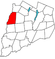
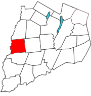
Norwich is a town in Chenango County, New York, United States. The population was 3,998 at the 2010 census.

<span class="mw-page-title-main">Oxford, New York</span> Town in New York, United States

Oxford is a town in Chenango County, New York, United States. The town contains a village also named Oxford. Oxford is an interior town in the south-central part of the county, southwest of the city of Norwich. At the 2010 census the town population was 3,901. The name derives from that of the native town of an early landowner from New England.

<span class="mw-page-title-main">Milford, New York</span> Town in New York, United States

Milford is a town in Otsego County, New York, United States. The population was 3,044 at the 2010 census. Within town is the village of Milford. The town is northeast of the City of Oneonta.

<span class="mw-page-title-main">Unadilla, New York</span> Town in New York, United States

Unadilla is a town in Otsego County, New York, United States. As of the 2010 census, the town had a population of 4,392. The name is derived from an Iroquois word for "meeting place". Unadilla is located in the southwestern corner of the county, southwest of Oneonta. The village of Unadilla is located in the southern part of the town. The mayor of Unadilla is Jason Cotten.

References

  1. "2016 U.S. Gazetteer Files". United States Census Bureau. Retrieved July 4, 2017.
  2. "Population and Housing Unit Estimates" . Retrieved June 9, 2017.
  3. 1 2 "Geographic Identifiers: 2010 Demographic Profile Data (G001): New Berlin town, Chenango County, New York". U.S. Census Bureau, American Factfinder. Archived from the original on February 12, 2020. Retrieved November 20, 2014.
  4. "Population and Housing Unit Estimates" . Retrieved June 9, 2017.
  5. "Census of Population and Housing". Census.gov. Retrieved June 4, 2015.
  6. "U.S. Census website". United States Census Bureau . Retrieved January 31, 2008.
  7. "DEC Takes Ownership Of Hunts Pond State Park". WBNG. May 6, 2011. Archived from the original on March 3, 2016. Retrieved February 21, 2016.

42°35′N75°24′W / 42.583°N 75.400°W / 42.583; -75.400