New Castle, Kentucky

Last updated

New Castle, Kentucky
Henry County, Kentucky courthouse.jpg
Henry County courthouse in New Castle, Kentucky
Henry County Kentucky Incorporated and Unincorporated areas New Castle Highlighted 2155596.svg
Location of New Castle in Henry County, Kentucky.
Coordinates: 38°26′00″N85°10′08″W / 38.43333°N 85.16889°W / 38.43333; -85.16889
Country United States
State Kentucky
County Henry
Established1817 [1]
Incorporated1851 [1]
Government
  MayorTony Kurtz
Area
[2]
  Total0.41 sq mi (1.07 km2)
  Land0.41 sq mi (1.06 km2)
  Water0.00 sq mi (0.01 km2)
Elevation
[3]
837 ft (255 m)
Population
 (2020)
  Total884
  Density2,156.10/sq mi (832.94/km2)
Time zone UTC-5 (Eastern (EST))
  Summer (DST) UTC-4 (EDT)
ZIP code
40050
Area code 502
FIPS code 21-55596
GNIS feature ID2404359 [3]
Website www.newcastleky.com

New Castle is a home rule-class city in Henry County, Kentucky, United States. It is the seat of its county. [4] As of the 2010 census the population was 912. [5] African Americans attended New Castle Colored School prior to integration. [6]

Contents

History

New Castle was incorporated in 1817. [7]

The District Grand Lodge No. 19 of the Grand United Order of Odd Fellows, a fraternal organization of African Americans, was in New Castle. [8] The group's Washington Lodge #1513 in New Castle was established in 1872 by former slaves. A historical marker by its building commemorates its history. [9]

Geography

New Castle is located southwest of the center of Henry County. U.S. Route 421 follows Main Street and leads north 7 miles (11 km) to Campbellsburg and southeast 29 miles (47 km) to Frankfort. Louisville is 38 miles (61 km) to the southwest via Kentucky Route 146 and Interstate 71.

According to the United States Census Bureau, New Castle has a total area of 0.42 square miles (1.1 km2), of which 0.004 square miles (0.01 km2), or 1.04%, is water. [5]

Demographics

Historical population
CensusPop.Note
1830 538
1840 528−1.9%
1860 519
1870 67029.1%
1880 500−25.4%
1890 485−3.0%
1900 462−4.7%
1910 4681.3%
1920 397−15.2%
1930 44712.6%
1940 4878.9%
1950 63129.6%
1960 69910.8%
1970 7558.0%
1980 83210.2%
1990 8937.3%
2000 9192.9%
2010 912−0.8%
2020 884−3.1%
U.S. Decennial Census [10]

At the census [11] of 2000, there were 919 people, 382 households, and 239 families residing in the city. The population density was 2,067.0 inhabitants per square mile (798.1/km2). There were 409 housing units at an average density of 919.9 per square mile (355.2/km2). The racial makeup of the city was 92.60% White, 5.77% Black or African American, 0.98% from other races, and 0.65% from two or more races. Hispanic or Latino of any race were 1.52% of the population.

There were 382 households, out of which 29.8% had children under the age of 18 living with them, 41.6% were married couples living together, 17.5% had a female householder with no husband present, and 37.2% were non-families. 33.2% of all households were made up of individuals, and 17.3% had someone living alone who was 65 years of age or older. The average household size was 2.25 and the average family size was 2.86.

In the city, the population was spread out, with 22.7% under the age of 18, 7.9% from 18 to 24, 25.2% from 25 to 44, 25.0% from 45 to 64, and 19.0% who were 65 years of age or older. The median age was 40 years. For every 100 females, there were 77.8 males. For every 100 females age 18 and over, there were 73.2 males.

The median income for a household in the city was $24,931, and the median income for a family was $34,550. Males had a median income of $27,813 versus $19,615 for females. The per capita income for the city was $12,626. About 26.8% of families and 27.3% of the population were below the poverty line, including 34.4% of those under age 18 and 20.9% of those age 65 or over.

Culture and recreation

The Samuel Hieatt House, built in 1850, was listed on the National Register of Historic Places in 1982. [12]

Related Research Articles

<span class="mw-page-title-main">Livingston County, Kentucky</span> County in Kentucky, United States

Livingston County is a county located in the U.S. state of Kentucky. As of the 2020 census, the population was 8,888. Its county seat is Smithland and its largest community is Ledbetter. The county was established in 1798 from land taken from Christian County and is named for Robert R. Livingston, a member of the Committee of Five that drafted the U.S. Declaration of Independence. The county was strongly pro-Confederate during the American Civil War and many men volunteered for the Confederate Army. Livingston County is part of the Paducah, KY-IL Metropolitan Statistical Area. It is a prohibition or dry county with the exception of Grand Rivers which voted to allow alcohol sales in 2016.

<span class="mw-page-title-main">Briarwood, Kentucky</span> City in Kentucky, United States

Briarwood is a home rule-class city in Jefferson County, Kentucky, United States. The population was 435 at the 2010 census, down from 554 at the 2000 census.

<span class="mw-page-title-main">Cambridge, Kentucky</span> City in Kentucky, United States

Cambridge is a home rule-class city in Jefferson County, Kentucky, United States. The population was 175 at the 2010 census.

<span class="mw-page-title-main">Crossgate, Kentucky</span> City in Kentucky, United States

Crossgate is a home rule-class city in Jefferson County, Kentucky, United States. The population was 225 at the 2010 census.

<span class="mw-page-title-main">Hollow Creek, Kentucky</span> City in Kentucky, United States

Hollow Creek is a home rule-class city in Jefferson County, Kentucky, United States. The population was 783 at the 2010 census.

<span class="mw-page-title-main">Hurstbourne Acres, Kentucky</span> City in Kentucky, United States

Hurstbourne Acres is a home rule-class city in Jefferson County, Kentucky, United States. The population was 1,811 at the 2010 census, up from 1,504 at the 2000 census.

<span class="mw-page-title-main">Lynnview, Kentucky</span> City in Kentucky, United States

Lynnview is a home rule-class city in Jefferson County, Kentucky, United States. The population was 914 at the 2010 census.

<span class="mw-page-title-main">Moorland, Kentucky</span> City in Kentucky, United States

Moorland is a home rule-class city in Jefferson County, Kentucky, United States. The population was 431 as of the 2010 census.

<span class="mw-page-title-main">Norbourne Estates, Kentucky</span> City in Kentucky, United States

Norbourne Estates is a home rule-class city in Jefferson County, Kentucky, United States. The population was 441 at the 2010 census.

<span class="mw-page-title-main">Old Brownsboro Place, Kentucky</span> City in Jefferson County, Kentucky, United States

Old Brownsboro Place is a home rule-class city in Jefferson County, Kentucky, United States, and a part of the united Metro government. The population was 353 at the 2010 census.

<span class="mw-page-title-main">Sycamore, Kentucky</span> City in Kentucky, United States

Sycamore is a home rule-class city in Jefferson County, Kentucky, United States. The population was 160 at the 2010 census.

<span class="mw-page-title-main">Thornhill, Kentucky</span> City in Kentucky, United States

Thornhill is a home rule-class city in Jefferson County, Kentucky, United States. The population was 178 at the 2010 census.

<span class="mw-page-title-main">Westwood, Jefferson County, Kentucky</span> City in Kentucky, United States

Westwood is a home rule-class city in Jefferson County, Kentucky, United States. The population was 634 at the 2010 census.

<span class="mw-page-title-main">Fort Mitchell, Kentucky</span> City in Kentucky, United States

Fort Mitchell is a home rule-class city in Kenton County, Kentucky, United States. The population was 8,702 at the 2020 census. It is part of the Cincinnati metropolitan area.

<span class="mw-page-title-main">Grand Rivers, Kentucky</span> City in Kentucky, United States

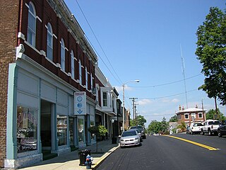
Grand Rivers is a home rule-class city in Livingston County, Kentucky, in the United States. The population was 382 at the 2010 census, up from 343 in 2000. It is part of the Paducah, KY-IL Metropolitan Statistical Area.

<span class="mw-page-title-main">Owenton, Kentucky</span> City in Kentucky, United States

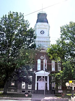
Owenton is a home rule-class city in and the county seat of Owen County, Kentucky, United States. The population was 1,327 at the 2010 census. It is located at the junction of U.S. Route 127 and Kentucky Route 22, about halfway between Louisville and Cincinnati.

<span class="mw-page-title-main">Masonboro, North Carolina</span> Former census-designated place in North Carolina, United States

Masonboro was a census-designated place (CDP) in New Hanover County, North Carolina. The last census count in 2000 was 11,812. Masonboro was located southeast of Wilmington near the Atlantic coast.

<span class="mw-page-title-main">Newton Township, Pennsylvania</span> Place in Pennsylvania, United States

Newton Township is a township in Lackawanna County, Pennsylvania, United States. The population was 2,823 at the 2020 census.

<span class="mw-page-title-main">Mayville, Clark County, Wisconsin</span> Town in Wisconsin, United States

Mayville is a town in Clark County in the U.S. state of Wisconsin. The population was 919 at the 2000 census.

<span class="mw-page-title-main">Pleasureville, Kentucky</span> City in Kentucky, United States

Pleasureville is a home rule-class city in Henry and Shelby counties, Kentucky, United States. The population was 834 at the time of the 2010 U.S. Census.

References

  1. 1 2 Commonwealth of Kentucky. Office of the Secretary of State. Land Office. "New Castle, Kentucky". Accessed 15 September 2013.
  2. "2020 U.S. Gazetteer Files". United States Census Bureau. Retrieved March 18, 2022.
  3. 1 2 U.S. Geological Survey Geographic Names Information System: New Castle, Kentucky
  4. "Find a County". National Association of Counties. Retrieved June 7, 2011.
  5. 1 2 "Geographic Identifiers: 2010 Demographic Profile Data (G001): New Castle city, Kentucky". American Factfinder. U.S. Census Bureau. Retrieved July 5, 2017.[ dead link ]
  6. https://www.courier-journal.com/story/news/local/oldham/2017/09/08/grand-odd-fellows-lodge-repairs-african-americans-kentucky-lodges-washington-lodge-united-order/632367001/
  7. Collins, Lewis (1877). History of Kentucky. p. 338.
  8. https://filsonhistorical.org/research-doc/grand-united-order-of-odd-fellows-in-america-records-1911-1946/
  9. https://www.hmdb.org/m.asp?m=136171
  10. "Census of Population and Housing". Census.gov. Retrieved June 4, 2015.
  11. "U.S. Census website". United States Census Bureau . Retrieved January 31, 2008.
  12. "NRHP nomination form". National Park Service . Retrieved October 19, 2012.