
Huron County is a county located in the U.S. state of Ohio. As of the 2020 census, the population was 58,565. Its county seat is Norwalk. The county was created in 1809 and later organized in 1815.
Calcium is a census-designated place (CDP) in Jefferson County, New York, United States. The population was 3,573 as of the 2020 census. The CDP is in the town of Le Ray and includes the hamlets of Calcium and Sanfords Four Corners.

Huron is a city in Erie County, Ohio, United States, located at the mouth of the Huron River on Lake Erie. The population was 6,922 at the 2020 census. It is part of the Sandusky micropolitan area.

Norwalk is a city in and the county seat of Huron County, Ohio, United States. The population was 17,068 at the 2020 census. The city is the center of the Norwalk micropolitan area and part of the Cleveland–Akron–Canton combined statistical area. Norwalk is located approximately 10 miles (16 km) south of Lake Erie, 51 miles (82 km) west/southwest of Cleveland, 59 miles (95 km) southeast of Toledo, and 58 miles (93 km) west/northwest of Akron.

Oakwood is an unincorporated area and census-designated place (CDP) in Lawrence County, Pennsylvania, United States. The population was 2,270 at the 2010 census.
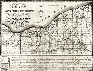
The Firelands, or Sufferers' Lands, tract was located at the western end of the Connecticut Western Reserve in what is now the U.S. state of Ohio. It was legislatively established in 1792, as the "Sufferers' Lands", and later became named "Fire Lands" because the resale of the land was intended as financial restitution for residents of the Connecticut towns of Danbury, Fairfield, Greenwich, Groton, New Haven, New London, Norwalk, and Ridgefield. Their homes had been burned in 1779 and 1781 by British forces during the American Revolutionary War. However, most of the settlement of the area did not occur until after the War of 1812. "Fire Lands" was later spelled as one word: "Firelands."
Oxford Township is one of the nine townships of Erie County, Ohio, United States. It is part of the Sandusky, Ohio micropolitan statistical area and the Cleveland-Akron-Canton Combined Statistical Area. The 2020 census recorded 1,140 residents.

Georgetown is an unincorporated community and census-designated place (CDP) in Bart Township, Lancaster County, Pennsylvania, United States. As of the 2010 census, the population was 1,022. Georgetown has a post office for P.O. boxes that is called Bart and has the ZIP code of 17503. Otherwise, the CDP is divided into three ZIP code areas for more distant communities.

State Route 598 (SR 598) is a 23.43-mile-long (37.71 km) north–south state highway in the northern portion of the U.S. state of Ohio. The southern terminus of SR 598 is at a signalized intersection where it meets SR 19, SR 61 and SR 309 in Galion. Its northern terminus is at SR 103 nearly 1.75 miles (2.82 km) east of Willard.

Buford is an unincorporated community and census-designated place in central Clay Township, Highland County, Ohio, United States. The population was 306 at the 2020 census. It once had a post office, with the ZIP code 45110. The current ZIP code 45171 is for nearby Sardinia.

Tippecanoe is an unincorporated community and census-designated place (CDP) in central Washington Township, Harrison County, Ohio, United States. It is located along State Route 800 in the valley of Stillwater Creek, a north-flowing tributary of the Tuscarawas River. It had a post office until 2011 with the ZIP code 44699. The population was 83 at the 2020 census.

Collins is a census-designated place (CDP) in central Townsend Township, Huron County, Ohio, United States. As of the 2020 census the population of the CDP was 628. The CDP includes the unincorporated communities of Collins and East Townsend. Collins has a post office, with the ZIP code of 44826.

Miamitown is a census-designated place (CDP) in western Whitewater Township, Hamilton County, Ohio, United States. The population was 1,256 at the 2020 census. It has a post office with the ZIP code 45041.

East Rochester is an unincorporated community and census-designated place (CDP) in southern West Township, Columbiana County, Ohio, United States. The population was 224 as of the 2020 census. It lies along U.S. Route 30, and has a post office with the ZIP code 44625. It is a part of the Salem micropolitan area, about 20 miles (32 km) east of Canton.

Smoketown is an unincorporated village and census-designated place (CDP) in East Lampeter Township, Lancaster County, Pennsylvania, United States. Also known as Smoke Town, it is served by the Smoketown Airport. As of the 2010 census, it had a population of 357.

Celeryville is an unincorporated community and census-designated place (CDP) on the boundary between New Haven and Richmond townships in Huron County, Ohio, United States. Celeryville is located approximately 1 mile (1.6 km) south of Willard, and the community relies on Willard's social services. As of the 2020 census the population of the community was 222.

McElhattan is a census-designated place (CDP) in Wayne Township in southern Clinton County, Pennsylvania, United States. As of the 2010 census, the population was 598.

Salem Heights is an unincorporated community and census-designated place (CDP) in Columbiana County, Ohio, United States. It was first listed as a CDP prior to the 2020 census, in which its population was 336. Salem Heights sits on the 1,275-foot (389 m) Blackburn Hill, separated from the city of Salem by the valley of the Middle Fork of the Little Beaver Creek. It is part of the Salem micropolitan area.
Lincoln Heights is an unincorporated area and census-designated place (CDP) in Richland County, Ohio, United States. It was first listed as a CDP prior to the 2020 census.
Castleton Four Corners is a census-designated place (CDP) in the town of Castleton, Rutland County, Vermont, United States. It consists of the unincorporated villages of Castleton Corners and Hydeville. As of the 2020 census, the CDP had a population of 699, out of 4,458 in the entire town.

