The route was first assigned in 1938, when the state took over maintenance of the fifth segment of Ocean County Route13 built in 1929, intending it to reach old Route37 (now part of Route35) in Bay Head from Beaver Dam Road, a distance of 1.76 miles (2.83km). The takeover did not reach that point, and the bridge and its approaches count for 0.56 miles (0.90km) of the intended length. The original bridge collapsed in 1962, and a temporary structure was erected later that year. Planning for a permanent replacement bridge continued for several years until construction finally began in 1970. This structure opened in 1972, but closed immediately afterward due to a failure of the lift mechanism, which was fixed by the end of the year. In late 2004, the bridge and its approaches received a rehabilitation.
Route description
View east at milepost 0 at the west end of Route13 in Point Pleasant
Route13 begins at an intersection where CR632 meets Hollywood Boulevard in Point Pleasant. There, the state-maintenance begins. The route heads eastward along Bridge Avenue, passing to the south of local businesses and to the north of local residences. There, Route13 begins a curve to the northeast onto the Lovelandtown Bridge approach, passing a marina before reaching the Point Pleasant Canal (part of the Intracoastal Waterway) and heading onto a lift bridge called the Lovelandtown Bridge. After crossing the canal, Route13 parallels Elm Avenue for a short distance before turning away to the southeast. The route heads into downtown Bay Head, where it reaches an intersection with Bay Avenue, which is its eastern terminus. CR632 continues eastward to Route35. Route13 is concurrent with CR632 for its entire length.[1][2]
Originally, the Lovelandtown Bridge was constructed in 1929 to create a continuous route along Bridge Avenue.[5] Route13 originated as an alignment of Ocean County Route13-E, a highway maintained by the county. In 1938, the state legislated a takeover of the fifth segment of the county route, a portion of highway from old Route37 (now part of Route35) at Bay Head to an intersection with Beaver Dam Road, including the Lovelandtown Bridge. The route was to be 1.76 miles (2.83km) long,[6] and the designation came into effect on July 2, 1938.[3] However, the extension to Route37 was never constructed. In the 1953 renumbering, the state dropped the suffix and renumbered the bridge and its approaches as Route13. (Incidentally, the portion of Route 37 within Bay Head -- running from Point Pleasant to Seaside Heights -- was renumbered as Route 35 during the same highway renumbering.)[4]
Lovelandtown Bridge rebuild
Collapse and demands for new bridge (1962–1964)
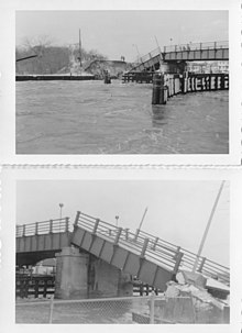
The damaged sections of the old Lovelandtown Bridge
By 1960, the structural integrity of the Lovelandtown Bridge came into question. The New Jersey State Highway Department felt that the bridge was structurally safe and able to support up to 20tons (18.14tonnes). However, local officials felt the bridge was unsafe, especially for vehicles such as school buses. Additionally, the bridge, which was supported by wooden pilings, was starting to fail and erode. The expected failure occurred during the Ash Wednesday Storm of 1962 on March5, when the storm and tides on the Intracostal Waterway wiped out a section of the bridge.[7] A temporary structure to replace the bridge opened in May1962.[8]
In the meantime, proposals were made for a permanent replacement structure. Early proposals noted the bridge would take about three months to rebuild.[9]Point Pleasant Police Chief William Beecroft, who voiced concerns about the integrity of the bridge in 1960 and 1962, proposed a new tunnel across the Intracoastal Waterway to replace the Route88 and Route13 bridges. Beecroft speculated that the new tunnel would be cheaper to build in the long run and make things easier for emergency vehicles who would not have to deal with drawbridges.[10] The State Highway Department considered a new tunnel for Route13, but quickly discarded the idea by October due to excessive costs, though Beecroft would bring it up again as an option if there were a hearing.[11]
In November1962, the State Highway Department made plans to build a new 45 feet (14m) high fixed structure over the waterway. However, this plan was opposed by multiple agencies and individuals because yachts would be unable to use the waterway with a fixed structure. One of these was Assemblyman William T. Hiering, a Republican from Ocean County who asked the United States Army Corps of Engineers to hold a public hearing on such a bridge; this hearing would occur on December27.[12][13] However, the State Highway Department also supported an option for a 30 feet (9.1m) high drawbridge that would accommodate yacht users and only have to be opened once in a while. Such a plan would cost about $2million.[11]
By February1964, the State Highway Department switched its plan to a vertical-lift bridge. This new bridge would be able to open to as high as 100 feet (30m) in the air and allow room for yachts to go through.[14] The delay in action by the Highway Department was being slammed by the borough of Point Pleasant by December1964. Dr. Ronald V. Crescenzo, one of the members of the borough council wanted a bus ban over the replaced structure until a new one could be built. The borough also wanted to be absolved of any responsibility and liability in case of another structural failure. They did, however, support a new vertical-lift bridge with the 25 feet (7.6m) high lift that could raise to 70 feet (21m) in the air.[15]
Added pressure (1965–1966)
Heading westbound onto the Lovelandtown Bridge, which is most of Route13's alignment
More complaints came from higher officials in September1965, when a resident of Fair Lawn drove off the temporary Lovelandtown Bridge and died. The car crashed through the wooden railings of the bridge and landed in the canal below. The driver's death sparked the attention of State SenatorWayne Dumont and Point Pleasant Mayor Walter B. Brown; they deemed the bridge a traffic hazard and pressured GovernorRichard J. Hughes to speed up construction. Dumont also claimed that the previous governor's administration provided money for the new bridge.[16] However, the State Highway Department claimed that no money was ever allocated for such use.[17]
In December1965, the borough of Point Pleasant noted that meetings between them, Ocean County and the State Highway Department would be conducted on December9 or December16, to discuss a new Lovelandtown Bridge. Chief Beecroft, who previously wanted a tunnel crossing, noted buses were taken off the temporary structure for safety.[18] By December3, Point Pleasant announced that the meeting would take place on December16.[19]
In January1966, the New Jersey State Conservation Department approved the plans of the State Highway Department for the construction of a new Lovelandtown Bridge. This new bridge would need a 60 feet (18m) horizontal clearance and a vertical clearance of 65 feet (20m) to help navigation through the canal. Bridge Avenue would be moved north for the new bridge, with the construction of a new alignment. This would help eliminate curves that were considered dangerous to the old bridge. However, the bridge was still subject to the approval of a United States Engineer in Philadelphia, Pennsylvania.[20] These plans reached the United States Army Corps of Engineers in April1966, when they announced openings for anyone who had opposition to the project.[21] By the deadline of May16, no objections were filed with the engineers on the new bridge.[22]
In July1966, the state announced that they were ready to begin construction of a new Lovelandtown Bridge, but they would have to wait until the Army Corps of Engineers announced their full approval of the project. The state felt that a new bridge would not be finished until 1968, but would at least get approval within a span of four to six weeks. However, the bridge alignment changed in April to have an 80 feet (24m) vertical clearance due to new regulations for future expansion of the canal.[23]
Design and funding problems (1967–1968)
However, despite the four to six week timeline, the Army Corps of Engineers did not sign off on the new Lovelandtown Bridge until January26, 1967. The new bridge would have a vertical clearance of 30 feet (9.1m) when closed and 65 feet (20m) when raised. The span would be 80 feet (24m) wide for boats and barges to clear. The newly-renamed New Jersey Department of Transportation (NJDOT) said design, planning and construction would take about 18months. Mayor Brown noted that he was happy and was willing to even bring his shovel.[24]
Survey work by the Army Corps of Engineers began in July1967, for the design of the new bridge over the waterway. NJDOT also hired a New York firm to do the survey work.[25] Less than a month later, the mechanisms to help open the Lovelandtown Bridge to marine traffic broke on August16, resulting in a seven-hour closure of the bridge and several days of repairs.[26] The Army Corps completed their survey work in the canal in November1967.[27]
By December1967, NJDOT moved test borings to the Bureau of Navigation offices to make plans for the new Lovelandtown Bridge ones. The offices would end up being relocated as part of the construction of the new bridge, due to be finished in 1971.[28] The Board of Adjustment chair for the borough of Point Pleasant noted that they should pressure the state to move their schedule up in response to the collapse of the Silver Bridge in Point Pleasant, West Virginia.[29] However, the state announced that they did move their timeline up and expected a replacement to be finished now in 1970, since design problems were avoided during that period. The state also noted that the new bridge would require the condemnation of as many as 20houses.[30] Drilling into the Point Pleasant Canal began on January2, 1968, when NJDOT inserted borings for new bridge supports.[31]
However, by September1968, Point Pleasant wanted to know why the $2million set aside by the state for construction of the new bridge had been shifted to help facilitate the Aldene Plan in Union County. The new bridge, now costing $4million (1968USD), no longer was in the funding for the state. The borough demanded an answer from Governor Hughes, which did not come with answers. Hughes noted that if the state voters passed a new bond issue, the Lovelandtown Bridge would be a top priority. This was in direct conflict with a promise by the State Highway Department in 1966, that money for the new bridge would be non-reliant on a bond issue or other strings. The borough demanded that Commissioner David Goldberg meet with borough officials to get the missing answers.[32]
That meeting would be scheduled for October8, 1968, at the offices for Goldberg in Trenton, with Mayor Brown heading out to discuss the problems.[33] Brown noted to the press that he wanted $4million of $114million earmarked for new railcars as part of the Aldene Plan to be shifted to a new bridge. He also noted that multiple members of the State Legislature, including Senator Hiering, along with Benjamin Mabie and John Brown of the Assembly would introduce legislation to help get funding earmarked immediately for the bridge.[34]
Brown's attitude changed once the meeting with Goldberg ended, feeling that Goldberg had been unsympathetic to their concerns and problems with the change in funding. Brown told the Asbury Park Evening Press that Goldberg gave them a "snow job" and would still force them to rely on the November5 bond issue of $640million for transportation work. Mabie, Brown and Hiering noted that they would introduce their response bills once the Legislature reconvened after the election. Goldberg disagreed stating that even if the bond issue failed with the voters, he would have $40million in funding and the odds of funding would be 5–1 for the project. Mabie, along with Chief Beecroft intended to vote against the bond issue on November5. Brown, still concerned the bridge was going to fall into the canal again, was refuted by Goldberg who stated it is safe and would close it if he felt it was not.[35]
Funding and land acquisition (1968–1969)
With the money for the Lovelandtown Bridge construction reliant on passing of the public bond issue, Senator Hiering showed his support for the new bond to help pay for transportation projects.[36] Assemblyman Brown, though not public, opposed the new bond issue. He was concerned that Ocean County would be left out of most of its benefits, and he also felt there was voter discontent. Mabie, however, continued to show his support and optimism for the new bond issue,[37] which passed on November5, 1968, by 502,415 votes.[38] NJDOT then promised a multitude of projects in Ocean County, including construction on Routes37 and 72 and the Lovelandtown Bridge.[39]
In January1969, the New Jersey State Legislature approved to spend $242million of the new bond issue. $110million would go to the construction of transportation projects immediately, including the Lovelandtown Bridge.[40] In late January, the state started notifying property owners in the way of the new bridge and approach about the condemnation of their properties. Property owners noted they had 90days to negotiate with the state about proper return values. The Asbury Park Evening Press noted that nine of the properties were on Partridge Run and the remaining 11 would be west of the canal.[41]
However, Goldberg announced to Ocean County officials that there would be more delays in all projects besides the widening of Route37 through Toms River until 1970.[42] Despite the report by Goldberg, Assemblyman Brown noted in March1969 that NJDOT was about ready to announce the advertisement for bids on a new bridge. Brown noted that Goldberg was saying they were moving forward rapidly on the bridge.[43] By April, tax assessors were working on estimating tax values for the properties to be acquired for the new Lovelandtown alignment.[44] By August, the borough approved to sell land along Bridge Avenue for construction of the new bridge.[45]
In September1969, the state noted that they would be ready to advertise and accept bids on the new project starting in late October1969.[46] NJDOT said they could have shovels in the ground during 1969 if all went well, including property acquisition. 15houses would be demolished by the project, but only one had been acquired by September 18, 1969, the one at 1644 Elm Street, once owned by the Federal Housing Administration and would be sold at auction in Cherry Hill. They felt construction would be finished by mid-1971 after starting in December1969.[47] This did not go according to plan as NJDOT had to file a condemnation lawsuit against James Duff, a property owner along the west side of the canal that was in the way of the new bridge. The request was made to get a three-man panel to come to an agreement on what Duff would be paid for the property for the future western approach.[48]
Despite the lawsuit, the state did open advertising on bids in late October1969.[49] Despite the plan for bid announcements on November26, within a week of the advertising, NJDOT was in court again, this time of a property on Central Avenue in Point Pleasant owned by William Hall. The borough of Point Pleasant was also named as a defendant as they claimed to have a lien on the property Hall owned.[50] The borough of Bay Head noted that they would only lose one property for construction and that their municipality would not be disrupted during construction of the new bridge.[51] However, the project would take over four parcels in total for the new bridge and approaches in Bay Head.[52]
Construction (1969–1972)
On November27, 1969, the state announced that they received the lowest bid of $3,344,933.85 (1969USD) for construction of the new bridge from a joint venture of Mason–Connor, Incorporated of Pennsauken and Thomas Construction of Albany, New York. The new bridge would be 287 feet (87m) long and 62 feet (19m) wide, with new approaches. Bridge Avenue on both sides would be turned into dead ends while the new Bridge Avenue alignment would fork off of Hollywood Avenue in Point Pleasant and Bay Avenue in Bay Head. The two supporting piers of the bridge would be 80 feet (24m) apart from each other. Other bids ranged from $3,386,522–$4,318,141. At that time, NJDOT noted it was studying the low bid and a deal could be made in two weeks.[53]
Point Pleasant announced in December1969 that they would vacate parts of Central Avenue so construction could begin on the new Lovelandtown Bridge. New road would wipe out parts of Central Avenue due to the new alignment.[54] Point Pleasant also asked in January1970, that the state widen Bridge Avenue at the southern side instead of the northern side of the roadway so that a costly sewer relocation would not be required.[55]
On January8, 1970, the state announced that they awarded the contract to Mason–Connor and Thompson Construction for the new bridge. The new bridge would have a deadline of December 15, 1971, to be finished, all to the delight of Beecroft, who began the push for the new bridge a decade prior.[56] Residents of both communities visited a display to see the new renderings of the bridge on January16 at the Point Pleasant Municipal Building. There it was announced that construction would begin on January26, 1970.[57] By January29, demolition work begun on the old marine police headquarters as part of property clearing. However, due to the construction, the work was being done at the station in Monmouth Beach. Fearing lack of police patrol, an officer would be stationed on a boat near the old headquarters to help in the cause.[58] They would end up moving to a new facility on Route35 in April1971.[59]
William Hall, who the state had sued earlier to acquire some of his property, noted in March1970, that the contractors were burning fires at the Lovelandtown Bridge construction site and that the smoke from the fires was polluting the air and his property. Hall noted that the fires were being started by burning old rubber tires and the Point Pleasant Borough Attorney noted that it was a violation of code to do so. Beecroft stepped in and asked the contractor to stop, despite the fact that he saw no burning going on at the property and got assurances that it would stop.[60]
Along with the burning of tires, Beecroft also asked NJDOT in March1970, to ask the contractor to stop routing their dump trucks over the Route88 bridge in Point Pleasant. A police officer noted the bridge was being used by dump trucks for the contractor weighing as much as 40tons. The weight would cause the draw leaves of the Route88 bridge to shift as much as 12 inches (0.30m), a dangerous amount of jump for the structure. The main concern of the dirt-loaded dump trucks was more of the safety of schoolchildren crossing the bridge at the same time as the dump trucks. If the bridge opened like that and a child got stuck in the leaves, it would mean immediate amputation. The state asked the trucks to slow down on the bridge to reduce the jump in the bridge, but that was still not enough for Beecroft who was ready to make sure they were flagged down Route35 to reach the bridge instead.[61] However, by the next week, the bridge was still being used by the dump trucks and any thought of the reroute would require changes to the contract in terms of cost.[62]
By late May, the construction on the pilings for the new bridge piers had begun, with the steel bases constructed.[63] However, work was slowed when the cases for the pilings began to have problems without specially-designed seals to keep them in place. The state and the contractor could not come to terms and instead, extra costs would be added anyway under "time and materials". The extra seals would add $50,000–$100,000 to the total cost of the project as contracted. The contractor was confident it would be finished near schedule, but no guarantee of on time. Construction did resume in mid-August.[64]
In November, there were complaints by Bay Head residents about the Bridge and Bay Avenue intersection being ripped up and left unpaved due to construction. While NJDOT said new curbs would be installed soon, no paving of the roads could start until the spring of 1971. They noted they would likely do it in April.[65]
By March1971, the concrete piers for the new bridge were finished and the supports for the deck of the road spans were being installed. The contractor noted that the work was 50percent complete at that point. Most importantly, the project was still slated to be complete by December1971.[66] By May, the state closed parts of Bridge Avenue in Point Pleasant to detour traffic off a two-block section. This was needed to help construct the new western approach to the Lovelandtown Bridge and was to remain in place through the end of construction.[67] However, this detour led to complaints from Point Pleasant about the strain it put on Route88 in pre-summer traffic. The borough demanded that NJDOT adjust things to help lighten the load.[68]
Construction of the first half of the elevator structure for the bridge began by June1971, with one side finished by the end of the month. Preparations for the other side of the bridge structure were also taking place.[69] The full structure was up by July15, with construction of the road deck beginning with the bridge in the elevated position.[70]
In October, the borough of Point Pleasant asked for the work to be amended that sidewalks would be built on the new bridge. The new bridge was not designed to have one, just four lanes of traffic. However, the project was now due to be finished in February1972.[71]
Opening and bridge failure (1972–1973)
On January20, 1972, NJDOT announced that the new bridge would open within two weeks (circa February 5) if everything stayed on schedule.[72] However, just four days later, they announced a new delay to the Spring of 1972 due to an issue with the electronic controls for the new bridge. They also said the spokesman from four days prior was incorrect in his announcement about a February1972 opening.[73] In late March, NJDOT announced they would soon begin testing on the new elevated structure for barge movement. The main control panel had been set in, but some parts had yet to be delivered. Testing continued through April, and NJDOT expected the bridge to open later that month.[74][75]
On May 10, the state announced that the new bridge would open to traffic after a ceremony on May23 at 11:00am.[76] Numerous dignitaries attended the ceremony, including Mayor Valenti of Point Pleasant and Assemblyman Franklin Berry Jr. (R-Ocean). The ceremony commemorated the 12years of effort to help build a new bridge over the canal. At the same time, local officials used the ceremony to push help for Route88, which also needed a new span.[77]
As part of the original contract with Mason–Connor and Thompson Construction, the old span would be demolished.[77] However, in mid-June, the state announced the old bridge would be used by motorists once again. The new span needed its opening mechanisms adjusted, resulting in a several week closure of the new span.[78] These adjustments were completed by the end of July.[79] The bridge closed again on August31, 1972,[80] with the mechanisms requiring more adjustments; detours were conducted through the old bridge.[81] By September12, it was announced the new span would continue to be closed until the problem of why the bridges was not closing properly was figured out and fixed, resulting in at least another two weeks of delay.[80]
On October16, 1972, it was announced that NJDOT engineers would have to submit plans by October25 to fix the broken lift structure. By this point, there was no certain day on when the new bridge would reopen.[82] Engineers announced on October27 that the bridge was likely failing to close because of lack of weight on the structure. Their proposals were to add weight to the structure to help it close properly. They were not sure how long this project improvement would take, requiring continued use of the old bridge.[83] These problems were finally corrected in December1972,[84] and the bridge finally reopened to traffic on December14 at 3:00pm.[85]
The old Lovelandtown bridge was swung open and process began on demolishing the old structure in January1973.[86] As demolition continued on the bridge, the United States Coast Guard put out buoys noting the locations of the old pilings for the bridge, located 45 feet (14m) apart from each other just under the surface.[87] The work continued into May on removing the piles from the site of the piers, which had been blasted apart in the demolition process.[88]
Modernization
The Lovelandtown Bridge and its approaches underwent a structural rehabilitation in October 2004. The lift mechanism was replaced to allow for quicker and more efficient raising and lowering of the bridge deck. The construction was completed by Carr & Duff Inc., which had received the project in June of that year. NJDOT and Governor James E. McGreevey forwarded $2.4 million (2005 USD) to the company for construction, which was completed by mid-2005. The project was part of the governor's "Fix-it First" initiative, which prioritized repairing existing roadway capacity throughout the state over building new capacity.[89]
Route 18 is a 42.8-mile-long (68.9 km) state highway in the central part of the US state of New Jersey. It begins at an intersection with Route 138 in Wall Township, Monmouth County and ends at Interstate 287 (I-287) in Piscataway Township, Middlesex County. Route 18 is a major route through central New Jersey that connects the Jersey Shore to the Raritan Valley region, connecting the county seats of Monmouth (Freehold) and Middlesex respectively. The route runs through Ocean Township, Marlboro Township, and East Brunswick, as for much of the route is a limited-access freeway. The remainder of the route is a multi-lane divided highway with traffic lights in the East Brunswick and Old Bridge areas. Route 18 was designated in 1939 as a proposed freeway from Old Bridge to Eatontown. The section west of Old Bridge was formerly designated as part Route S28, a prefixed spur of State Highway Route 28 from Middlesex to Matawan. The designation, assigned in the 1927 renumbering, remained until a second renumbering in 1953. At that point, Route S28 was redesignated as Route 18, though the section from Old Bridge to Matawan was signed as TEMP 18, as this section would be decommissioned when the Route 18 freeway was built.
Route 35 is a state highway in the U.S. state of New Jersey, primarily traveling through the easternmost parts of Middlesex, Monmouth, and Ocean counties. It runs 58.11 mi (93.52 km) from the entrance to Island Beach State Park in Berkeley Township, Ocean County to an intersection with Route 27 in Rahway, Union County. Between Seaside Park and Mantoloking, Route 35 follows the right-of-way of the former Pennsylvania Railroad along the Jersey Shore. The route heads through Point Pleasant Beach and crosses the Manasquan River on the Brielle Bridge, meeting Route 34 and Route 70 at the former Brielle Circle in Wall Township. From there, Route 35 heads north and intersects Route 138, an extension of Interstate 195, continuing north through Monmouth County before crossing the Victory Bridge over the Raritan River into Perth Amboy, has where the route continues north to Rahway.
Route 52 is a state highway in the southern part of the U.S. state of New Jersey. The highway runs 2.74 mi (4.41 km) from 9th Street in Ocean City, Cape May County north to U.S. Route 9 in Somers Point, Atlantic County. It is composed mostly of a series of four-lane divided bridges over Great Egg Harbor Bay from Ocean City to Somers Point known as the Howard S. Stainton Memorial Causeway, also known as the Ninth Street Bridge. The remainder of the route is a surface road called MacArthur Boulevard that runs from the causeway to U.S. Route 9. This section of the route formerly included the Somers Point Circle, now a traffic light, where Route 52 intersects County Route 559 and County Route 585.
Route 72 is a state highway in the U.S. state of New Jersey. It runs 28.74 mi (46.25 km) from the Four Mile Circle with Route 70 in Woodland Township in Burlington County to County Route 607 in Ship Bottom on Long Beach Island in Ocean County. Route 72 travels through the Pine Barrens as a two-lane undivided road. After an interchange with the Garden State Parkway, the route becomes a four- to six-lane divided highway through built-up areas of Manhawkin and crosses the Manahawkin Bay via the Manahawkin Bay Bridge onto Long Beach Island.
The Garden State Parkway (GSP) is a controlled-access toll road that stretches the north–south length of eastern New Jersey from the state's southernmost tip near Cape May to the New York state line at Montvale. Its name refers to New Jersey's nickname, the "Garden State". The parkway is designated by the New Jersey Department of Transportation (NJDOT) as Route 444, although this designation is unsigned. At its north end, the road becomes the Garden State Parkway Connector, a component of the New York State Thruway system that connects to the Thruway mainline in Ramapo. The parkway is the longest highway in the state at approximately 172 miles (277 km), and, according to the International Bridge, Tunnel and Turnpike Association, was the busiest toll road in the United States in 2006. Most of the highway north of the Raritan River runs through heavily populated areas. Between the Raritan River and the township of Toms River, the highway passes through lighter suburban development, while south of Toms River, the road mostly runs through unspoiled wilderness in the Pine Barrens and swampland. The highway has a posted speed limit of 65 miles per hour (105 km/h) for most of its length and is primarily for passenger vehicle use; trucks weighing over 10,000 pounds (4,500 kg) are prohibited north of exit 105.
The Pulaski Skyway is a four-lane bridge-causeway in the northeastern part of the U.S. state of New Jersey, carrying an expressway designated U.S. Route 1/9 (US 1/9) for most of its length. The structure has a total length of 3.502 miles (5.636 km). Its longest bridge spans 550 feet (168 m). Traveling between Newark and Jersey City, the roadway crosses the Passaic and Hackensack rivers, Kearny Point, the peninsula between them, and the New Jersey Meadowlands.
Metropark station is an intermodal transportation hub on the Northeast Corridor in the Iselin section of Woodbridge Township in Middlesex County, New Jersey that is located 24.6 miles southwest of New York Penn Station. It is owned and operated by NJ Transit and serves Amtrak and NJ Transit's Northeast Corridor Line. NJ Transit runs peak period 'loop' buses in coordination with train schedules.
Interstate 287 (I-287) is an auxiliary Interstate Highway in the US states of New Jersey and New York. It is a partial beltway around New York City, serving the northern half of New Jersey and the counties of Rockland and Westchester in New York. I-287, which is signed north–south in New Jersey and east–west in New York, follows a roughly horseshoe-shaped route from the New Jersey Turnpike (I-95) in Edison, New Jersey, clockwise to the New England Thruway (I-95) in Rye, New York, for 98.72 miles (158.87 km). Through New Jersey, I-287 runs west from its southern terminus in Edison through suburban areas. In Bridgewater Township, the freeway takes a more northeasterly course, paralleled by US Route 202 (US 202). The northernmost part of I-287 in New Jersey passes through mountainous surroundings. After crossing into New York at Suffern, I-287 turns east on the New York State Thruway (I-87) and runs through Rockland County. After crossing the Hudson River on the Tappan Zee Bridge, I-287 splits from I-87 near Tarrytown and continues east through Westchester County on the Cross-Westchester Expressway until it reaches the New England Thruway. Within New Jersey, I-287 is maintained by the New Jersey Department of Transportation (NJDOT), and, within New York, it is maintained by the New York State Thruway Authority (NYSTA).
The Broadway Bridge is a vertical-lift bridge across the Harlem River Ship Canal in the borough of Manhattan in New York City. It connects the neighborhoods of Inwood on Manhattan Island and Marble Hill on the mainland. The bridge consists of two decks. The lower deck carries Broadway, which is designated as U.S. Route 9 at this location. The upper deck carries the New York City Subway's IRT Broadway–Seventh Avenue Line, serving the 1 train.
Interstate 80 (I-80) is a major Interstate Highway in the United States, running from San Francisco, California, eastward to the New York metropolitan area. In New Jersey, I-80 runs for 68.35 miles (110.00 km) from the Delaware Water Gap Toll Bridge at the Pennsylvania state line to its eastern terminus at I-95 in Teaneck, Bergen County. I-95 continues from the end of I-80 to the George Washington Bridge for access to New York City. The highway runs parallel to US Route 46 (US 46) through rural areas of Warren and Sussex counties before heading into more suburban surroundings in Morris County. As the road continues into Passaic and Bergen counties, it heads into more urban areas. The New Jersey Department of Transportation (NJDOT) identifies I-80 within the state as the Christopher Columbus Highway.
Point Pleasant Beach is a train station located in Point Pleasant Beach, in Ocean County, New Jersey, United States, on NJ Transit's North Jersey Coast Line, and is one of the most significant stops on the NJCL portion between Long Branch and Bay Head. This station is located on one of the borough's major arteries, Arnold Avenue, Route 35, several blocks from the Atlantic Ocean, boardwalk, Manasquan Inlet marina, and within the community's downtown business, shopping, dining and entertainment nexus. The current building and platforms are approximately 10 years old, a consequence of the station's redevelopment yielding the modern fixtures and services. The station is handicapped-accessible.
County Route 567 is a county highway in the U.S. state of New Jersey. The highway extends 10.02 miles (16.13 km) from Amwell Road in Hillsborough Township to Union Avenue in Raritan Borough.
The Thousand Islands Parkway (often written as 1000 Islands Parkway) is a scenic parkway in the Canadian province of Ontario. It extends easterly from an interchange with Highway 401 in Gananoque for approximately 40 kilometres (25 mi) to rejoin Highway401 near the community of Butternut Bay, west of Brockville. The parkway follows the north shore of the St. Lawrence River, and was formerly designated Highway2S (S for Scenic) until 1970. It passes through the communities of Gray's Beach, Halsteads Bay, Ivy Lea, Darlingside, Rockport, Narrows, La Rue Mills and Mallorytown Landing, as well as providing access to the three inland properties of the Thousand Islands National Park. Highway 137, which meets the parkway near its midpoint, provides access to the Interstate 81 in New York via the Thousand Islands Bridge.
The Beesley's Point Bridge was a bridge in New Jersey, United States, that was built privately by the Ocean City Automobile Club in 1927. Completed in 1928, control of the bridge was acquired by the Beesley's Point Bridge Company. It was a toll bridge from its opening. Prior to its closing, it was best known for carrying U.S. Route 9 (US 9) over the Great Egg Harbor Bay, connecting Upper Township, in Cape May County to Somers Point in Atlantic County. The bridge concurrently carried the Garden State Parkway over the Great Egg Harbor Bay from the Parkway's opening in 1954 until a separate bridge over the bay for the Parkway, the Great Egg Harbor Bridge, opened in 1955.
New York State Route 282 (NY 282) is a north–south state highway located within Tioga County in the Southern Tier of New York in the United States. It extends for 3.48 miles (5.60 km) from the Pennsylvania state line in the town of Nichols, where it connects to Pennsylvania Route 187 (PA 187), to an intersection with NY 17C in the town of Tioga. The route meets the Southern Tier Expressway (NY 17) and crosses over the Susquehanna River just west of the village of Nichols.
Asbury Park is an NJ Transit railway station in Asbury Park, in Monmouth County, New Jersey, United States. It is served by trains on the North Jersey Coast Line. It is located along Cookman Avenue between Main Street and Memorial Drive. The current Asbury Park station is one of two original Asbury Park stations on the line. The North Asbury Park station still exists, but is no longer a station stop; the former station was located at the Sunset Avenue crossing.
Ridgefield Park station, also known as West Shore Station, was a railroad station in Ridgefield Park, New Jersey at the foot of Mount Vernon Street served by the New York, Susquehanna and Western Railroad (NYSW) and the West Shore Railroad, a division of New York Central (NYCRR). The New York, Ontario and Western Railway (NYO&W) had running rights along the West Shore and sometimes stopped at Ridgefield Park. First opened in 1872 it was one of three passenger stations in the village, the others being the Little Ferry station to the south and Westview station to the north. Service on the West Shore Railroad began in 1883. The station house, built at a cost $100,000 opened in 1927. Southbound service crossed Overpeck Creek and continued to terminals on the Hudson River waterfront where there was connecting ferry service across the Hudson River to Manhattan. Northbound near Bogota the parallel NYSW and West Shore lines diverge and continue into northern New Jersey, Pennsylvania, and upstate New York. Passenger service ended in 1966.
The Brigantine Bridge is a vehicular bridge over Absecon Inlet in Atlantic County, New Jersey. It is located just west of the Atlantic Ocean in Atlantic City and the resort community of Brigantine, providing the only road access to Brigantine Island. It is owned and operated by the New Jersey Department of Transportation (NJDOT). The bridge carries New Jersey Route 87, which then becomes County Route 638 at its northern end. At its southern end it connects with the Atlantic City–Brigantine Connector.
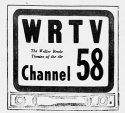
WRTV was a television station that broadcast on channel 58 in Asbury Park, New Jersey, United States. It was owned by the Walter Reade Organization and broadcast as an independent station between January 22, 1954, and April 1, 1955, in hopes of securing a VHF channel for the station that never came. In the 1960s, Reade attempted to move the unbuilt station from channel 58 in Asbury Park to channel 68 in Newark, which was treated as an application for a new station; granted in 1970, Reade sold the permit before it went on air.
↑ General Assembly, New Jersey (1938). "238". OCEAN COUNTY ROUTE 13-E. Beginning at highway Route37 at Bay Head and continuing one and seventy-six one-hundredth (1.76) miles to the Beaver Dam road, in the boroughs of Point Pleasant and Bay Head, county of Ocean, and to include the Lovelandtown bridge across the Manasquan canal now under the jurisdiction of the Board of Commerce and Navigation, passing all right and title therein to the State Highway Commissioner. New Jersey State Legislature. pp.541–1.
↑ "Bond Questions Approved Easily". The Asbury Park Evening Press. 1, 5. November 6, 1968. Retrieved March 16, 2020– via Newspapers.com.{{cite news}}: External link in |location= (help)CS1 maint: location (link)
This page is based on this Wikipedia article Text is available under the CC BY-SA 4.0 license; additional terms may apply. Images, videos and audio are available under their respective licenses.