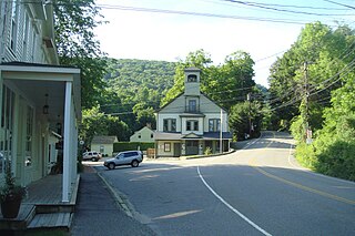
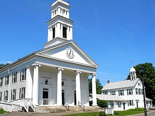
Preston City is a village and the original town center of the town of Preston, Connecticut. The core of the village around the junction of Old Northwest Road and Route 164 is designated as the Preston City Historic District, a historic district that is listed on the National Register of Historic Places. The district is located along Old Shetucket and Amos Roads, which, prior to the 1930s, were major thoroughfares.
The Woodstock Hill Historic District is a historic district encompassing the historic village center of Woodstock, Connecticut. It is centered on the Woodstock Green, extending south from there toward the junction of Connecticut Route 169 and Plaine Hill Road. Major buildings in the district include the 1821 Congregational Church, the buildings of Woodstock Academy, and Roseland Cottage, a National Historic Landmark that is one of the nation's finest Gothic Revival summer houses. The district was listed on the National Register of Historic Places in 1999.

The Flanders Historic District is a historic district that encompasses a small cluster of late-18th to early-19th century residential structures north of the center of Kent, Connecticut, which was the original heart of the community when it was first settled. It is centered at the junction of United States Route 7 with Cobble Road and Studio Hill Road. The area was supplanted by the current town center in the 1840s. The district was listed on the National Register of Historic Places in 1979.

The Five Corners Historic District is a historic district encompassing the central district of the village of South Williamstown, Massachusetts. It is centered at the junction of Cold Spring, Green River, New Ashford. The junction has been a prominent center in the area since 1760. Prominent buildings in the district include the South Center School, the Store at Five Corners, and the Second Congregational Church. The district was listed on the National Register of Historic Places in 1993.

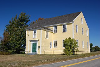
The West Granville Historic District is a historic district encompassing the center of West Granville, Massachusetts. The village is composed mainly of buildings form the late 18th and early 19th centuries, including an 18th-century church and 1830s academy building. The district was listed on the National Register of Historic Places in 1991.

The East Plymouth Historic District is a historic district in the town of Plymouth, Connecticut. It encompasses a small rural village in the northeastern part of the town, whose main focus is the 1792 St. Matthew's Church, one of the oldest surviving Episcopal church buildings in the state. The district runs along East Plymouth Road on either side of its junction with Marsh Road, and includes predominantly Greek Revival residential buildings erected in the early to mid-19th century. The district was listed on the National Register of Historic Places in 1985.

Goshen Historic District is a historic district encompassing the town center village of Goshen, Connecticut. Centered at the junction of Connecticut Routes 4 and 63, the village developed historically as a rural crossroads of two turnpikes, and has retained its rural character. It is dominated by residential architecture from the first half of the 19th century, and includes churches, a store, and the town's former 1895 town hall. It was listed on the National Register of Historic Places in 1982.

The Milton Center Historic District encompasses the historic 19th-century village center of Milton in the northwestern part of the town of Litchfield, Connecticut. Basically linear, it stretches from Milton Cemetery in the west to the junction of Milton and Shearshop Roads in the east, including houses, churches, schools, and the remains of industrial sites. The district was listed on the National Register of Historic Places in 1986.
The Orange Center Historic District Church encompasses the historic town center of Orange, Connecticut. Centered on the town green at the junction of Meetinghouse Lane and Orange Center Road, it has retained its character as a 19th-century agrarian town center despite significant 20th-century suburbanization around it. Originally established as a local historic district in 1978, it listed on the National Register of Historic Places in 1989.

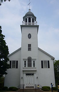
The South Canaan Congregational Church is a historic Congregational church building at Connecticut Route 63 and Barnes Road in the town of Canaan, Connecticut. Built in 1804, it is a remarkably well-preserved example of early Federal period church architecture. It was listed on the National Register of Historic Places in 1983.
The Plymouth Center Historic District encompasses historic early village center of Plymouth, Connecticut. Stretching along Main, North and South Streets from their junction, it flourished in the 19th century with small-scale industries, but declined late in the century with the separation of Thomaston and the more significant industrial development at Terryville. The district features colonial, Federal, and Greek Revival architecture and was added to the National Register of Historic Places in 1999, with a slight enlargement the following year.
Bridgewater Center Historic District encompasses the traditional town center of Bridgewater, Connecticut. Centered at the junction of Main Street with Clapboard and Hat Shop Hill Roads, it developed in the early 19th century as a civic center, even before the town's 1856 incorporation from New Milford. The architecture of the center is largely reflective of the first half of the 19th century, including Greek Revival and Federal style buildings. It was listed on the National Register of Historic Places in 2000.

The Woodbury Historic District No. 1 encompasses the linear town center of Woodbury, Connecticut. Extending along two miles of Main Street, from Flanders Road in the north to Old Sherman Hill Road in the south, the district represents an architectural cross section of the town history, from the late 17th century to the present. It was added to the National Register of Historic Places on March 11, 1971.

The Washington Green Historic District encompasses the historic village green of the town of Washington, Connecticut, and much of the surrounding village center. It extends mainly along Kirby and Woodbury Roads, and includes a diverse collection of architecture from the 18th to early 20th centuries. It was listed on the National Register of Historic Places in 1995.
The Charlotte Center Historic District encompasses the historic 19th-century town center of Charlotte, Vermont. Settled c. 1790 and developed mainly in the mid-19th century, the village, stretched along Church Hill Road west of Hinesburg Road, retains a well-preserved 19th-century atmosphere of residential, civic, and commercial buildings. The district was listed on the National Register of Historic Places in 1984.

The Burlington–Harmony Hill Roads Historic District encompasses a historic rural agricultural crossroads village in eastern Harwinton, Connecticut. Stretching mainly along Harmony Hill Road north of its junction with Burlington Road, it includes residential buildings dating from the mid-18th to late 19th centuries. The district was listed on the National Register of Historic Places in 1996.

The Colebrook Center Historic District encompasses the town center of Colebrook, Connecticut. Located in an isolated valley at the junction of Connecticut Route 183 with Rockwell and Smith Hill Roads, the village was established in 1767, and has seen little change since about 1860. It was listed on the National Register of Historic Places in 1991.

The Litchfield–South Roads Historic District encompasses part of the traditional town center of Harwinton, Connecticut. Settled in the second quarter of the 18th century, and centered at the junction of Connecticut Route 4 with North and South Roads, the town center includes a variety of mainly 19th century residential architecture, several churches, and municipal buildings. It was listed on the National Register of Historic Places in 1996.

The Phelps Farm Historic District encompasses a collection of farm and residential properties on Connecticut Route 183 and Prock Hill Road in Colebrook, Connecticut. This area is a virtually intact mid-19th century farmstead, with its land under a single family's ownership since the 18th century. The district was listed on the National Register of Historic Places in 1983.