New River, Arizona

Last updated

New River, Arizona
New River-Welcome to New River Marker.jpg
Welcome sign
Maricopa County Arizona Incorporated and Unincorporated areas New River Highlighted 0449360.svg
Location in Maricopa County and the state of Arizona
USA Arizona location map.svg
Red pog.svg
New River
Usa edcp location map.svg
Red pog.svg
New River
Coordinates: 33°52′9″N112°5′9″W / 33.86917°N 112.08583°W / 33.86917; -112.08583
Country United States
State Arizona
County Maricopa
Area
[1]
  Total56.12 sq mi (145.35 km2)
  Land56.11 sq mi (145.32 km2)
  Water0.01 sq mi (0.03 km2)
Elevation
2,014 ft (614 m)
Population
 (2020) [2]
  Total17,290
  Density308.16/sq mi (118.98/km2)
Time zone UTC-7 (MST (no DST))
ZIP codes
85087 (New River)
85086 (Phoenix)
Area code 623
FIPS code 04-49360
GNIS feature ID 0008605

New River is an unincorporated community and census-designated place (CDP) in Maricopa County, Arizona, United States. The population was 17,290 as of the 2020 census, [2] up from 14,952 at the 2010 census. [3]

Contents

History

Phillip "Lord" Darrell Duppa Phillip Darrell Duppa.jpg
Phillip "Lord" Darrell Duppa

New River is named after the seasonal wash of the same name, part of the Agua Fria River system which drains into the Salt River. The community was founded by Lord Darrell Duppa in 1868 as a stagecoach stop. For many years it was the terminus of the old Black Canyon Highway (now Interstate 17). The pavement ended in New River and continued as a dirt road to the city of Prescott. [4]

Geography

New River is located in northern Maricopa County at 33°52′9″N112°5′9″W / 33.86917°N 112.08583°W / 33.86917; -112.08583 (33.869149, −112.085759). [5] It is bordered by the Tonto National Forest to the north, Cave Creek to the east, Phoenix to the south, and Phoenix and Anthem to the west. The CDP includes the area known as Desert Hills. New River is approximately 36 miles (58 km) north of downtown Phoenix.

According to the United States Census Bureau, the CDP has a total area of 56.1 square miles (145 km2), of which 0.01 square miles (0.03 km2), or 0.02%, are water. [1] 3,176-foot (968 m) Daisy Mountain and 2,980-foot (910 m) Gavilan Peak are within the community.

Demographics

Historical population
CensusPop.Note
2000 10,740
2010 14,95239.2%
2020 17,29015.6%
U.S. Decennial Census [6]

As of the census of 2000, there were 10,740 people, 3,921 households, and 3,066 families residing in the CDP. The population density was 151.6 inhabitants per square mile (58.5/km2). There were 4,514 housing units at an average density of 63.7 per square mile (24.6/km2). The racial makeup of the CDP was 95.9% White, 0.4% Black or African American, 0.6% Native American, 0.5% Asian, 0.1% Pacific Islander, 1.3% from other races, and 1.4% from two or more races. 4.9% of the population were Hispanic or Latino of any race.

There were 3,921 households, out of which 35.3% had children under the age of 18 living with them, 68.9% were married couples living together, 5.6% had a female householder with no husband present, and 21.8% were non-families. 15.3% of all households were made up of individuals, and 2.9% had someone living alone who was 65 years of age or older. The average household size was 2.73 and the average family size was 3.04.

In the CDP, the population was spread out, with 26.0% under the age of 18, 4.8% from 18 to 24, 33.2% from 25 to 44, 28.5% from 45 to 64, and 7.5% who were 65 years of age or older. The median age was 38 years. For every 100 females, there were 103.9 males. For every 100 females age 18 and over, there were 102.4 males.

The median income for a household in the CDP was $62,307, and the median income for a family was $68,604. Males had a median income of $46,361 versus $31,610 for females. The per capita income for the CDP was $25,932. About 3.6% of families and 5.7% of the population were below the poverty line, including 5.5% of those under age 18 and 3.1% of those age 65 or over.

As of the census of 2010 the population of the New River CDP area was 14,952. This is nearly a two thirds growth from the previous census. The total housing units nearly doubled from 3,921 in 2000 to 6,753 in 2010. [7]

New River CDP area is within Maricopa County District 3. According to 2010 census numbers, the New River CDP consists of about 2% of Maricopa County District 3 and only 0.3% of Maricopa County. [8]

Government

New River is served by Deer Valley Unified School District.

Fire and emergency service is provided through the Daisy Mountain Fire District. [9]

Many residents previously relied on water delivered by state-licensed water haulers from fire hydrants located in Phoenix. As of August 2018, water is hauled from a filling station operated by Epcor. [10] [11]

Incorporation efforts

New River, and its neighbor Desert Hills, are unincorporated areas in Maricopa County which in 2019 was named the fastest-growing county in the United States for the third year running. While parts of Maricopa have had considerable development, New River has held off. New River has attempted to "incorporate" a number of times in its history, so as to control zoning regulations and development in the area. [12]

Local attractions

Daisy Mountain New River-Gavilan Peak.jpg
Daisy Mountain

Historic structures in New River

Pictured are some of the few remaining historic structures of New River. [22]

See also

Related Research Articles

<span class="mw-page-title-main">Maricopa County, Arizona</span> County in Arizona, United States

Maricopa County is in the south-central part of the U.S. state of Arizona. As of the 2020 census the population was 4,420,568, or about 62% of the state's total, making it the fourth-most populous county in the United States and the most populous county in Arizona, and making Arizona one of the nation's most centralized states. The county seat is Phoenix, the state capital and fifth-most populous city in the United States.

<span class="mw-page-title-main">Pinal County, Arizona</span> County in Arizona, United States

Pinal County is in the central part of the U.S. state of Arizona. According to the 2020 census, the population of the county was 425,264, making it Arizona's third-most populous county. The county seat is Florence. The county was founded in 1875.

<span class="mw-page-title-main">Ehrenberg, Arizona</span> CDP and ghost town in La Paz County, Arizona

Ehrenberg, also historically spelled "Ehrenburg", is an unincorporated community and census-designated place (CDP) in La Paz County, Arizona, United States. The population was 1,470 at the 2010 census. Ehrenberg is named for its founder, Herman Ehrenberg.

<span class="mw-page-title-main">Cave Creek, Arizona</span> Town in Maricopa County, Arizona

Cave Creek is a town in Maricopa County, Arizona, United States. It is part of the Phoenix metropolitan area. As of the 2020 census, the population of the town was 4,892.

<span class="mw-page-title-main">Gila Bend, Arizona</span> Town in Maricopa County, Arizona

Gila Bend, founded in 1872, is a town in Maricopa County, Arizona, United States. The town is named for an approximately 90-degree bend in the Gila River, which is near the community's current location. As of the 2020 census, the population of the town was 1,892.

<span class="mw-page-title-main">Guadalupe, Arizona</span> Town in Maricopa County, Arizona

Guadalupe is a town in Maricopa County, Arizona, United States and part of the greater Phoenix metropolitan area. The town motto, "where three cultures flourish", recognizes the town's roots in the Yaquis, Mexicans and descendants of the original farmers. Since its founding, Guadalupe has been known as a center of Yaqui culture, and it is home to many religious festivals. Nestled between Phoenix and Tempe, the 2020 census listed the population of the town as 5,322. Guadalupe was founded around 1900 by Yaqui Indians, who fled their homeland in Sonora to avoid oppression by the Mexican government of Porfirio Díaz. The cemetery of Guadalupe was established in 1904, in the original townsite. The cemetery is now officially located in Tempe, due to that city's annexation of the land surrounding the cemetery; however, it is still administered by the Guadalupe Clerk's Office. Guadalupe is primarily a residential area; most residents commute to other parts of the Phoenix area to work.

<span class="mw-page-title-main">Peoria, Arizona</span> City in Arizona, United States

Peoria is a city in Maricopa and Yavapai counties in the U.S. state of Arizona. Most of the city is located in Maricopa County, while a portion of it in the north is in Yavapai County. It is a major suburb of Phoenix. As of the 2020 census, the population of Peoria was 190,985, up from 154,065 in 2010. It is the sixth-largest city in Arizona in land area and the ninth-largest in population. It was named after Peoria, Illinois. The word peoria is a corruption of the Miami-Illinois word for "prairie fire". It is the spring training home of the San Diego Padres and Seattle Mariners, who share the Peoria Sports Complex.

<span class="mw-page-title-main">Queen Creek, Arizona</span> Town in Maricopa and Pinal counties, Arizona

Queen Creek is a town in Maricopa and Pinal counties, Arizona, United States. The population was 59,519 at the 2020 census. It is a suburb of Phoenix, located in the far southeast area of the Phoenix Metropolitan Area. A large battery factory is currently being constructed by LG.

<span class="mw-page-title-main">Rio Verde, Arizona</span> CDP in Maricopa County, Arizona

Rio Verde is a master-planned community just east of Scottsdale, in Arizona. It is also a census-designated place (CDP) in Maricopa County, Arizona, United States, located in the far, far northeast area of the whole Phoenix Metropolitan Area. The population was 2,210 as of the 2020 census, up from 1,811 at the 2010 census.

<span class="mw-page-title-main">Sun City West, Arizona</span> City in Arizona, United States

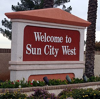
Sun City West is an unincorporated community and census-designated place (CDP) in Maricopa County, Arizona, United States. The population was 25,806 at the 2020 census.

<span class="mw-page-title-main">Sun Lakes, Arizona</span> CDP in Maricopa County, Arizona

Sun Lakes is an unincorporated community and census-designated place (CDP) in Maricopa County, Arizona, United States. The population was 14,868 at the 2020 census. Sun Lakes is an active adult community comprising five country club communities in three homeowner associations. These include the gated communities of Oakwood and IronWood (IronOaks), the gated and non-gated communities of Palo Verde and Cottonwood, and the non-gated community of Sun Lakes 1. Sun Lakes is a master-planned community developed by Robson Communities.

<span class="mw-page-title-main">Desert Hills, Arizona</span> CDP in Mohave County, Arizona

Desert Hills is an unincorporated community and census-designated place (CDP) in Mohave County, Arizona, United States. The population was 2,764 at the 2020 census, up from 2,245 at the 2010 census.

<span class="mw-page-title-main">Arizona City, Arizona</span> CDP in Pinal County, Arizona

Arizona City is an unincorporated census-designated place (CDP) in southwestern Pinal County, Arizona, United States. It is located near the junction of Interstate 8 and Interstate 10 at the midpoint between Phoenix and Tucson, approximately 60 miles (97 km) from the downtown of both cities. The population was 10,475 as of the 2010 U.S. Census. It is estimated to be approximately 11,030 as of a 2017 U.S. Census estimate. Arizona City is a rural, primarily residential community that features a 48-acre man-made lake which has an HOA and is private to residents of surrounding homes only. These attributes make the community a popular snowbird destination, with the population increasing by as much as 5,000 people in the winter months to reach the census figure of 11,030. Most recently after the last Census, many full-time residents have relocated to the unincorporate town.

<span class="mw-page-title-main">Maricopa, Arizona</span> City in Arizona, United States

Maricopa is a city in the Gila River Valley in Pinal County, Arizona, United States. With 66,290 residents as of 2022, Maricopa is the largest incorporated municipality in Pinal County.

<span class="mw-page-title-main">Black Canyon City, Arizona</span> CDP in Yavapai County, Arizona, US

Black Canyon City is an unincorporated community and census-designated place (CDP) in Yavapai County, Arizona, United States. The population is 2,677 as of the 2020 census.

<span class="mw-page-title-main">Mayer, Arizona</span> CDP in Yavapai County, Arizona

Mayer is a census-designated place (CDP) in Yavapai County, Arizona, United States. The population was 1,408 at the 2000 census. Mayer includes three sites listed on the National Register of Historic Places: the Mayer Apartments, the Mayer Business Block, and the Mayer Red Brick Schoolhouse.

<span class="mw-page-title-main">Tonopah, Arizona</span> CDP in Maricopa County, Arizona

Tonopah is an unincorporated community and census-designated place (CDP) in western Maricopa County, Arizona, United States, 52 miles (84 km) west of downtown Phoenix off Interstate 10. The community is near the Palo Verde Nuclear Generating Station, the largest power producer in the country, nuclear or otherwise. As of the 2020 census, the population of Tonopah was 23, down from 60 at the 2010 census.

<span class="mw-page-title-main">Anthem, Arizona</span> Place in Arizona, United States

Anthem is a planned community partially located within Phoenix and partially located within New River, a census-designated place. The community is entirely located in Maricopa County, Arizona, United States, within the Phoenix Metropolitan Area. As of the 2020 census, the population of the Anthem was 23,190.

<span class="mw-page-title-main">Komatke, Arizona</span> CDP in Maricopa County, Arizona

Komatke is a census-designated place in Maricopa County, Arizona, United States. The area currently comprising the census-designated place had a population of 1,013 at the 2020 census, up from 821 at the 2010 census. It is located within the Gila River Indian Community. Its name refers to the Sierra Estrella mountain range, which rises just to the southwest of Komatke.

<span class="mw-page-title-main">Gila Crossing, Arizona</span> CDP in Maricopa County, Arizona

Gila Crossing is a census-designated place (CDP) in Maricopa County, Arizona, United States, within the Gila River Indian Community south of Komatke. The population was 636 at the 2020 census.

References

  1. 1 2 "2021 U.S. Gazetteer Files: Arizona". United States Census Bureau. Retrieved May 17, 2022.
  2. 1 2 "New River CDP, Arizona: 2020 DEC Redistricting Data (PL 94-171)". U.S. Census Bureau. Retrieved May 17, 2022.
  3. "Census 2010: Arizona". usatoday.com. Retrieved April 22, 2018.
  4. "New River, Arizona History and Trivia". www.hometownusa.com. Retrieved April 22, 2018.
  5. "US Gazetteer files: 2010, 2000, and 1990". United States Census Bureau. February 12, 2011. Retrieved April 23, 2011.
  6. "U.S. Decennial Census". Census.gov. Retrieved May 10, 2014.
  7. Bureau, U.S. Census. "U.S. Census website". United States Census Bureau . Retrieved November 24, 2018.
  8. "U.S. Census Bureau QuickFacts: Maricopa County, Arizona". Census Bureau QuickFacts. Retrieved November 24, 2018.
  9. "daisymountainfire.org". daisymountainfire.
  10. "New River & Desert Hills Water Filling Station". www.epcor.com.
  11. "New River to get new water supply | Cronkite News". May 29, 2018.
  12. 1 2 Jessica Boehm (May 1, 2019). "New River residents feud over whether to become a city". The Arizona Republic . Supporters of the New River Desert Hills incorporation are hoping to get the question on the ballot in November. The last town to incorporate in Arizona was Tusayan in 2010, according to Ken Strobeck, executive director of the Arizona League of Cities and Towns. In order to get incorporation on the ballot, incorporation supporters must collect signatures from at least 10 percent of registered voters in the proposed city limits.
  13. 1 2 3 4 "NRDHIC – Archives". nrdhic.org. Retrieved November 24, 2018.
  14. "NRDHIC". nrdhic.org. Retrieved November 24, 2018.
  15. "NRDHIC". www.savenewriver.com. Retrieved November 24, 2018.
  16. "NRDHIC Press". www.nrdhic.org. Retrieved November 24, 2018.
  17. Ali Vetnar (April 9, 2019). "Some residents want North Valley community to become its own town". KTAR-FM. The group also needs to collect signatures from 10% of registered voters in the area to put the measure on the November ballot. Ricci said this effort has been going on for three decades, but they've never been able to bring issue to a vote.
  18. Robert Roy Britt (June 3, 2019). "Plan to Incorporate New River & Desert Hills Dies". North Phoenix News. Retrieved June 5, 2019.
  19. "Incorporation efforts halt – The Foothills Focus".
  20. "ASLD entire letter.PNG". Archived from the original on August 3, 2019.
  21. "Gavilan Peak, AZ". HikeArizona.com. Retrieved August 16, 2016.
  22. www.nerdmecca.com. "Jack Ass Acres, Arizona – Ghost Towns of Arizona and Surrounding States". www.ghosttownaz.info. Retrieved April 22, 2018.