
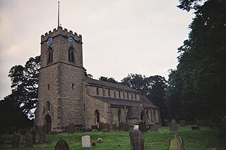
Ewerby is a village in the North Kesteven district of Lincolnshire, England. It lies 3 miles (4.8 km) north-east from Sleaford and 2 miles (3.2 km) south from Anwick. The hamlet of Ewerby Thorpe lies 0.7 miles (1.1 km) to the east from Ewerby.
Barrowby is a village and civil parish in the South Kesteven district of Lincolnshire, England. It is 2 miles (3.2 km) west of Grantham. It overlooks the Vale of Belvoir and has a Grade I listed parish church. The hamlet of Casthorpe is part of the parish. The 2001 Census listed 795 households and a population of 1,996, which fell to 840 households with 1,952 inhabitants at the 2011 census. It was estimated at 1,986 in 2019.

Thurlby is a village and civil parish in the South Kesteven district of Lincolnshire, England. It is situated just west of the A15 road, 2 miles (3 km) south from the town of Bourne, and on the edge of the Lincolnshire Fens. It is sometimes referred to as Thurlby by Bourne to distinguish it from other villages in Lincolnshire with the same name. Thurlby and the hamlet of Northorpe to its north are conjoined. The parish had a population of 2,136 at the 2001 census and 2,153 at the 2011 census.

Habrough is a village and civil parish in North East Lincolnshire, England, 8 miles (13 km) north-west of Grimsby and 3 miles (5 km) inland from the River Humber at the southern edge of the A180 road, just west of Immingham and south of South Killingholme. Humberside Airport is 4 miles (6.4 km) to the south-west.

Bilsby is a village and civil parish in the East Lindsey district of Lincolnshire, England. It lies on the main A1111 road between Alford and Sutton-on-Sea, 1 mile (1.6 km) east of Alford. Thurlby and Asserby are hamlets within Bilsby parish. The censuses showed a parish population of 538 in 2001 and 487 in 2011, with an estimate of 489 in 2019.

Hogsthorpe is a small village in the East Lindsey district of Lincolnshire, England. It is situated approximately 2 miles (3 km) from the North Sea and Chapel St Leonards, and about 7 miles (11 km) north from Skegness. Through Hogsthorpe runs the A52, the main road connecting the village to the nearby resorts of Skegness, Mablethorpe and Ingoldmells.

Kirton in Lindsey, also abbreviated to Kirton Lindsey, is a market town and civil parish in North Lincolnshire, England. It is 7 miles (11 km) south-east from Scunthorpe.

Huttoft is a village in the East Lindsey district of Lincolnshire, England, about 4 miles (6 km) east of the market town of Alford, on the A52 road between Ingoldmells and Sutton-on-Sea. John Betjeman, later England's Poet Laureate, visited Huttoft in the 1940s and devoted a poem to its parish church.

Fiskerton is a village and civil parish in the West Lindsey district of Lincolnshire, England. The population of the civil parish at the 2011 census was 1,209. It is situated approximately 6 miles (10 km) east from the city and county town of Lincoln, and on the north side of the River Witham. Also home of the reported cryptic "Fiskerton phantom".

Gosberton is a village and civil parish in the South Holland district of Lincolnshire, England. It is situated 9 miles (14.5 km) south-west of Boston, 6 miles (10 km) north of Spalding and 8.5 miles (14 km) north-west of Holbeach. The parish includes the villages of Gosberton Clough and Risegate, and the hamlets of Westhorpe and Gosberton Cheal. The population of Gosberton, which was approximately 2500, increased to 2,958 at the 2011 Census.
Scawby is a village and civil parish in North Lincolnshire, England. It is situated 2 miles (3 km) south-west from Brigg, and just east from the A15 road, and south from the M180 motorway. According to the 2001 Census, Scawby population was 2,277, reducing slightly to 2,243 at the 2011 census.

Owston Ferry is a village and civil parish in North Lincolnshire, England. It is situated on the west bank of the River Trent, and 9 miles (14 km) north from Gainsborough. It had a total resident population of 1,128 in 2001 including Kelfield. This increased to 1,328 at the 2011 census. Sometimes referred to as Owston or Ferry, the village forms part of the Isle of Axholme. It is bounded to the west by the A161 road and the village of Haxey. The River Trent is directly to the east. To the north, beyond a number of hamlets and villages, lies the River Humber. West Butterwick was originally a part of the township of Owston.
Cowbit is a village and civil parish in the South Holland district of Lincolnshire, England. The population of the civil parish at the 2011 census was 1,220. It is situated 3 miles (5 km) south from Spalding and 5 miles (8 km) north from Crowland.

Friskney is a village and civil parish within the East Lindsey district of Lincolnshire, England.

Withern is a village in the civil parish of Withern with Stain, in the East Lindsey district of Lincolnshire, England. It is situated on the A157 road, and 7 miles (11 km) south-east from Louth. Stain was once an independent parish but was combined with Withern when the old church of St John the Baptist was destroyed some centuries ago.

Legsby is a small village and civil parish in the West Lindsey district of Lincolnshire, England. The population of the civil parish at the 2011 census was 193. It is situated approximately 13 miles (20 km) north-east from the city and county town of Lincoln and 3 miles (5 km) south-east from the town of Market Rasen.

Swaby is a civil parish and village in the East Lindsey district of Lincolnshire, England, about 8 miles (13 km) north from Spilsby, and 6 miles (9.7 km) north-west from Alford. Whitepit is a hamlet half a mile west of the village.

Tumby is a village in the East Lindsey district of Lincolnshire, England. It is situated approximately 2 miles (3.2 km) north from Coningsby and 6.5 miles (10.5 km) south from Horncastle, and in the civil parish of Kirkby on Bain.
Carrington is a village and civil parish in the East Lindsey district of Lincolnshire, England. It is situated approximately 7 miles (11 km) north from the market town of Boston.

Toynton All Saints is a village and civil parish in the East Lindsey district of Lincolnshire, England, about 1.5 miles (2.4 km) south of the town of Spilsby.

