
Derbyshire is a ceremonial county in the East Midlands of England. It borders Greater Manchester, West Yorkshire, and South Yorkshire to the north, Nottinghamshire to the east, Leicestershire to the south-east, Staffordshire to the south and west, and Cheshire to the west. Derby is the largest settlement, and Matlock is the county town.

Derbyshire Dales is a local government district in Derbyshire, England. The district was created in 1974 as West Derbyshire; the name was changed to Derbyshire Dales in 1987. The council is based in the town of Matlock, and the district also includes the towns of Ashbourne, Bakewell, Darley Dale and Wirksworth, as well as numerous villages and extensive rural areas. Much of the district is within the Peak District National Park.

The White Peak, also known as the Low Peak, is a limestone plateau that forms the central and southern part of the Peak District in England. It is mostly between 270 metres (900 ft) and 430 metres (1,400 ft) above sea-level and is enclosed by the higher altitude Dark Peak to the west, north and east.

Hartington is a village in the centre of the White Peak area of the Derbyshire Peak District, England, lying on the River Dove which is the Staffordshire border. According to the 2001 census, the parish of Hartington Town Quarter, which also includes Pilsbury, had a population of 345 reducing to 332 at the 2011 Census. Formerly known for cheese-making and the mining of ironstone, limestone and lead, the village is now popular with tourists.

The River Dove is the principal river of the southwestern Peak District, in the Midlands of England, and is around 45 miles (72 km) in length. It rises on Axe Edge Moor near Buxton and flows generally south to its confluence with the River Trent at Newton Solney. From there, its waters reach the North Sea via the Humber Estuary. For almost its entire course it forms the boundary between the counties of Staffordshire and Derbyshire. The river meanders past Longnor and Hartington and cuts through a set of deep limestone gorges, Beresford Dale, Wolfscote Dale, Milldale and Dovedale.

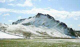
Wolfscote Hill is a limestone hill near the village of Hartington in the Derbyshire Peak District. The summit is 388 metres (1,273 ft) above sea level.

Hartington Nether Quarter is a civil parish in the Derbyshire Dales district of Derbyshire, England. The parish was created from the subdivision of the old Hartington parish. According to the 2001 census it had a population of 410, increasing to 434 at the 2011 Census. The parish includes Biggin, Friden, Heathcote, Newhaven and Pikehall.
Hartington Upper Quarter is a civil parish in the High Peak district of Derbyshire, England. The civil parish was created following the division of the ancient parish of Hartington into four. The parish had a population of 451 according to the 2001 census reducing to 438 at the 2011 Census.

Parsley Hay railway station served Parsley Hay, a hamlet within Hartington Middle Quarter civil parish, about 9.3 miles (15 km) south east of Buxton, Derbyshire, on the LNWR line to Ashbourne. The nearest large settlement is the village of Hartington.

Burbage is a village in the High Peak district, in the county of Derbyshire, England. At the 2011 Census Burbage was a ward of the High Peak Borough Council. The population taken at this Census was 2,540.

Hulme End is a small hamlet in Staffordshire, England, in the Peak District National Park 10 miles north of Ashbourne, Derbyshire. A natural gateway to the Manifold Valley, the river crosses the road from Hartington to Warslow.

Friden is a hamlet in the civil parish of Hartington Nether Quarter, Derbyshire, England. It is 11 miles (18 km) south-east of Buxton, just off the Newhaven to Cromford Via Gellia road, and lies within the Peak District National Park.

Fenny Bentley is a small village and civil parish located close to Dovedale in the Derbyshire Dales district of Derbyshire, England. The population in 2009 was 305 reducing to 183 at the 2011 Census. It lies two miles north of Ashbourne, on the A515 Buxton to Ashbourne Road. It is one of the most southerly villages in the Peak District.
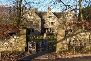
Hartington Hall is a much altered and extended 17th-century manor house at Hartington, Derbyshire, now a youth hostel.
Hartington Middle Quarter is a civil parish within the Derbyshire Dales district, which is in the county of Derbyshire, England. Formerly a part of Hartington parish, for which it is named, it has a mix of a number of villages and hamlets amongst a mainly rural and undulating landscape, and is wholly within the Peak District National Park. It had a population of 379 residents in 2011. The parish is 130 miles (210 km) north west of London, 20 miles (32 km) north west of Derby, and 5 miles (8.0 km) south east of the nearest market town of Buxton. Being on the edge of the county border, it shares a boundary with the parishes of Chelmorton, Flagg, Hartington Town Quarter, Hartington Upper Quarter, Middleton and Smerrill, Monyash in Derbyshire, as well as Hollinsclough, Longnor and Sheen in Staffordshire.
Middleton and Smerrill is a civil parish within the Derbyshire Dales district, in the county of Derbyshire, England. Largely rural except for the village of Middleton-by-Youlgreave and isolated farms, Middleton and Smerrill's population is 137 residents in 2011. It is 130 miles (210 km) north west of London, 20 miles (32 km) north west of the county city of Derby, and 4+1⁄2 miles (7.2 km) south west of the nearest market town of Bakewell. Middleton and Smerrill is wholly within the Peak District national park, in the southern part of the area. It is one of the largest parishes but among the smallest by way of residents, and shares a border with the parishes of Gratton, Hartington Middle Quarter, Hartington Nether Quarter, Hartington Town Quarter, Monyash and Youlgreave. There are 31 listed structures in Middleton and Smerrill.
Hartington Nether Quarter is a civil parish in the Derbyshire Dales district of Derbyshire, England. The parish contains 24 listed buildings that are recorded in the National Heritage List for England. Of these, one is listed at Grade II*, the middle of the three grades, and the others are at Grade II, the lowest grade. The parish is mainly rural, to the east of the village of Hartington, and it contains the settlements of Biggin, Friden, Heathcote, Newhaven and Pikehall. Most of the listed buildings are houses, cottages, farmhouses, and associated structures, and the others are a hotel, a church, and two mileposts.
Hartington Town Quarter is a civil parish in the Derbyshire Dales district of Derbyshire, England. The parish contains 39 listed buildings that are recorded in the National Heritage List for England. Of these, one is listed at Grade II*, the middle of the three grades, and the others are at Grade II, the lowest grade. The parish contains the village of Hartington and the surrounding countryside. Most of the listed buildings are houses, cottages, farmhouses, and associated structures. The other listed buildings include a church, hotels and public houses, a bridge, two mileposts, and a war memorial.

Hollins Hill is a gritstone hill in the Derbyshire Peak District near the village of Hollinsclough. The summit is 450 metres (1,480 ft) above sea level. The hill is the source of Swallow Brook, which flows into the River Dove running along the south side of the hill.

