Nine-Mile Island (Mississippi River)

Last updated
Nine-Mile Island
Nickname: Shinkles Island
Geography
LocationUpper Mississippi River
Coordinates 42°26′10″N90°34′30″W / 42.436°N 90.575°W / 42.436; -90.575
Area454 acres (184 ha)
Length2 mi (3 km)
Width.5 mi (0.8 km)
Administration
United States
StateIowa

Nine-Mile Island is a river island located in Mosalem Township, Dubuque County, Iowa, between Dubuque, Iowa and Bellevue, Iowa on the Upper Mississippi River.

River island Exposed land within a river.

A river island is any exposed land surrounded by river water. Properly defined it excludes shoals between seasonally varying flows and may exclude semi-coastal islands such as in deltas.

Dubuque County, Iowa County in the United States

Dubuque County is a county located in the U.S. state of Iowa. As of the 2010 census, the population was 93,653. The county seat is Dubuque. The county is named for Julien Dubuque, the first European settler of Iowa.

Dubuque, Iowa City in Iowa, United States

Dubuque is the county seat of Dubuque County, Iowa, United States, located along the Mississippi River. In 2017, the population of Dubuque was 57,637.

Contents

Geography

Nine-Mile Island is situated within Pool 12 of the Upper Mississippi River, between Locks and Dams Nos. 11 and 12. The head (northwestern end) of the island is at UMR river mile 574.3, with the southeastern end at mile 571.5. It is about 2 miles long and .5 mile at its widest point, with a total area of 454 acres. [1]

Lock and Dam No. 11 lock and dam on the Mississippi River located between Dubuque, Iowa and rural Grant County, Wisconsin, USA

General Zebulon Pike Lock and Dam No. 11 is a lock and dam located between Dubuque, Iowa and rural Grant County, Wisconsin, on the Upper Mississippi River.

Lock and Dam No. 12 lock and dam on the Mississippi River at Bellevue, Iowa, USA

Lock and Dam No. 12 is a lock and dam located on the Upper Mississippi River at Bellevue, Iowa, United States. The movable portion of the dam starts at the locks adjacent to the Iowa shore and is 849 feet (258.8 m) long, consisting of seven tainter gates and three roller gates. It connects to a 200-foot (61.0 m) storage yard and continues toward the Illinois shore with a 2,750-foot (838.2 m) non-submersible dike, a 1,200-foot (365.8 m) submersible dike and a 3,130-foot (954.0 m) non-submersible dike. The non-submersible sections are separated from the submersible section with two 120-foot (36.6 m) transitional dikes. The main lock is 110 feet (33.5 m) wide by 600 feet (182.9 m) long. There is also an incomplete auxiliary lock. In 2004, the facility was listed in the National Register of Historic Places as Lock and Dam No. 12 Historic District, #04000172 covering 1,017 acres (4.1 km2), 1 building, 3 structures, and 4 objects.

The island is immediately downriver from Frentress Lake, site of a popular marina in East Dubuque, Illinois and the former dock of the Silver Eagle Casino. It is adjacent to the unincorporated community of Massey, Iowa, which houses marina facilities. The island is bordered on the southwest by Molo Slough and on the northeast by the USACE's nine-foot navigation channel. Since it is on the Mississippi River, Nine-Mile Island is on the extreme eastern side of Iowa, adjacent to its border with Illinois.

East Dubuque, Illinois City in Illinois, United States

East Dubuque is a city in Jo Daviess County, Illinois, United States. The population was 1,704 at the 2010 census, down from 1,995 in 2000. East Dubuque is located alongside the Mississippi River. Across the river is the city of Dubuque, Iowa. About three miles north of the city is the Illinois – Wisconsin border.

United States Army Corps of Engineers federal agency under the Department of Defense and a major Army command

The United States Army Corps of Engineers (USACE) is a U.S. federal agency under the Department of Defense and a major Army command made up of some 37,000 civilian and military personnel, making it one of the world's largest public engineering, design, and construction management agencies. Although generally associated with dams, canals and flood protection in the United States, USACE is involved in a wide range of public works throughout the world. The Corps of Engineers provides outdoor recreation opportunities to the public, and provides 24% of U.S. hydropower capacity.

Mississippi River largest river system in North America

The Mississippi River is the second-longest river and chief river of the second-largest drainage system on the North American continent, second only to the Hudson Bay drainage system. Its source is Lake Itasca in northern Minnesota and it flows generally south for 2,320 miles (3,730 km) to the Mississippi River Delta in the Gulf of Mexico. With its many tributaries, the Mississippi's watershed drains all or parts of 32 U.S. states and two Canadian provinces between the Rocky and Appalachian mountains. The main stem is entirely within the United States; the total drainage basin is 1,151,000 sq mi (2,980,000 km2), of which only about one percent is in Canada. The Mississippi ranks as the fourth-longest and fifteenth-largest river by discharge in the world. The river either borders or passes through the states of Minnesota, Wisconsin, Iowa, Illinois, Missouri, Kentucky, Tennessee, Arkansas, Mississippi, and Louisiana.

The USACE also maintains two aids to navigation on the island: Nine-Mile Island Daybeacon at UMR river mile 573.5, and Nine-Mile Island Light at mile 571.5, both on the right descending bank. [2]

History

The island's name comes from the fact that its head is located nine river miles below Eagle Point ( 42°32′06″N90°38′42″W / 42.535°N 90.645°W / 42.535; -90.645 ). It was also historically known as Shinkles Island, as evidenced by the Army Corps' Shinkles Island Bar Daybeacon at UMR mile 574.1 on the left descending bank (Illinois side of the river). [3]

The island was also the site of a steamboat race in 1885 between the DAN THAYER and CLYDE. [4]

Paddle steamer steamship or riverboat powered by a steam engine that drives paddle wheels

A paddle steamer is a steamship or riverboat powered by a steam engine that drives paddle wheels to propel the craft through the water. In antiquity, paddle wheelers followed the development of poles, oars and sails, where the first uses were wheelers driven by animals or humans.

Conservation

Nine-Mile Island is densely forested, save for a sandy beach at the head of the island which is popular with vacationers. The area is characterized by numerous sloughs and backwaters, and the island surrounds Horseshoe Lake and Green Lake. Classified as public land, the island is part of both the Upper Mississippi River National Wildlife and Fish Refuge and the Driftless Area National Wildlife Refuge.

Prior to the construction of dams on the Upper Mississippi, thousands of wingdams regulated the flow of the river. Multiple remnants of these common structures are still present near the island. There is also a 1/2-mile revetment on the north side of the island and a 1/4-mile revetment on the southeastern end. [5]

Recreation

Since the island is just southeast of the Dubuque metropolitan area, it is a popular destination for boaters and picnickers. There are no roads on the island. Boats must be careful not to drop anchor at the head of the island, since there is an underground natural gas pipeline buried there, formerly owned by Enron Gas Pipeline Co. [6]

Related Research Articles

Des Moines County, Iowa County in the United States

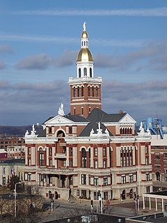
Des Moines County is a county located in the U.S. state of Iowa. As of the 2010 census, the population was 40,325. The county seat is Burlington. It is one of Iowa's two original counties along with Dubuque County; both were organized by the Michigan Territorial legislature in 1834.

Balltown, Iowa City in Iowa, United States

Balltown is a city in Dubuque County, Iowa, United States. It is part of the Dubuque, Iowa Metropolitan Statistical Area. The population was 68 at the 2010 census, down from 73 at the 2000 census. Balltown is home to Breitbach's Country Dining, Iowa's oldest restaurant and bar, which was founded in 1852 and twice rebuilt by the community, following its destruction by fire in 2007 and 2008.

Julien Dubuque Bridge

The Julien Dubuque Bridge crosses the Mississippi River. It joins the cities of Dubuque, Iowa, and East Dubuque, Illinois. The bridge is part of U.S. Route 20 route. It is one of two automobile bridges over the Mississippi in the area, and is listed in the National Register of Historic Places.

Maquoketa River river in the United States of America

The Maquoketa River is a tributary of the Mississippi River, approximately 150 miles (240 km) long, in northeastern Iowa in the United States. Its watershed covers 1,694 square miles (4,387 km2) within a rural region of rolling hills and farmland southwest of Dubuque. It is not to be confused with the Little Maquoketa River, another distinct direct tributary of the Upper Mississippi River meeting the Big River north of Dubuque. The river and its tributaries mark the border of the Driftless Area of Iowa, with the areas east of it not having been covered by ice during the last ice age. Its name derives from Maquaw-Autaw, which means "Bear River" in Meskwaki.

Mathias Ham House

The Mathias Ham House is a 19th-century house in Dubuque, Iowa that is on the National Register of Historic Places. It is located at the intersection of Shiras and Lincoln Avenues, near the entrances to Eagle Point Park and Riverview Park.

Mississippi Valley Division

The United States Army Corps of Engineers Mississippi Valley Division (MVD) is responsible for the Corps water resources programs within 370,000-square-miles of the Mississippi River Valley, as well as the watershed portions of the Red River of the North that are within the United States. It excludes the entire watersheds of the Missouri River and Ohio River, and portions of the Arkansas River and the Red River of the South, but otherwise encompasses the entire Mississippi River from Lake Itasca, Minnesota, to the Gulf of Mexico. The district includes all or parts of 13 states: Arkansas, Illinois, Iowa, Kentucky, Louisiana, Michigan, Minnesota, Mississippi, Missouri, North Dakota, Tennessee, Wisconsin, and South Dakota.

Upper Mississippi River National Wildlife and Fish Refuge

The Upper Mississippi River National Wildlife and Fish Refuge is a 240,000-acre (970 km2), 261-mile long (420 km) National Wildlife Refuge located in and along the Upper Mississippi River. It runs from Wabasha, Minnesota in the north to Rock Island, Illinois in the south.

Upper Mississippi River portion of the Mississippi River upstream of Cairo, Illinois

The Upper Mississippi River is the portion of the Mississippi River upstream of Cairo, Illinois, United States. From the headwaters at Lake Itasca, Minnesota, the river flows approximately 2000 kilometers (1250 mi) to Cairo, where it is joined by the Ohio River to form the Lower Mississippi River.

Dubuque Rail Bridge bridge in United States of America

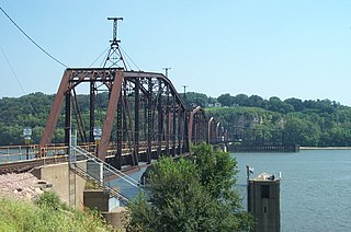
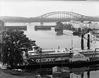
The Dubuque Rail Bridge carries a single rail line across the Mississippi River between Dubuque, Iowa, and East Dubuque, Illinois, near river mile 580.

Melvin Price Locks and Dam

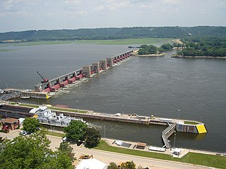
Melvin Price Locks and Dam is a dam and two locks at river mile 200.78 on the Upper Mississippi River, about 17 miles (27 km) north of Saint Louis, Missouri. The collocated National Great Rivers Museum, at 1 Lock and Dam Way, East Alton, Illinois, explains the structure and its engineering.

Catfish Creek (Iowa) river in United States of America

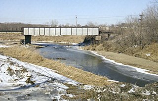
Catfish Creek is a 21.2-mile-long (34.1 km) tributary of the upper Mississippi River in northeastern Iowa. It rises southwest of Dubuque, just southeast of Peosta. The Middle Fork rises west of Dubuque and flows under and then parallel to U.S. Route 20; the former Illinois Central Railroad, now the Chicago Central and Pacific Railroad has its mainline in it. The remaining forks of the creek are all south of U.S. Route 52. Swiss Valley Park, maintained by Dubuque County, is along the main fork of the creek, which is a designated trout stream through the park. In recent years, people have been trying to stop the erosion in this relatively flat way out of the Gorge of the Upper Mississippi. The North Fork of the creek has been proposed for a trail/park.

U.S. Highway 52 is a 166-mile-long (267 km) United States highway in northeast Iowa. The route begins at the Dale Gardner Veterans Memorial Bridge over the Mississippi River between Sabula and Savanna, Illinois. From Sabula, it heads north along the Mississippi towards Bellevue and Dubuque. At Dubuque, US 52 briefly shares an expressway with U.S. Route 61 and U.S. Route 151.

Sny Magill Creek river in the United States of America

Sny Magill Creek is a minor tributary of the Upper Mississippi River, rising in central Clayton County, Iowa and flowing to the Upper Mississippi River approximately 2 miles north of Clayton, Iowa. It has a drainage of 22,780 acres (92.2 km2). It is regarded as one of the best trout streams in Iowa. The majority of this forested basin is incorporated into the Sny Magill-North Cedar Creek Wildlife Management Area.

Nine Mile Island may refer to:

U.S. Highway 67 (US 67) is a U.S. Highway in extreme eastern Iowa. The route begins in Davenport at the Rock Island Centennial Bridge where it crosses the Mississippi River and ends at an intersection with US 52 and Iowa Highway 64 (Iowa 64) west of Sabula. It passes through Bettendorf, Le Claire, and Clinton. Except for Folletts, every community which US 67 enters sits along the Mississippi River. As such, the entire route is part of the Great River Road, an All-American Road.

References

  1. "Electronic Code of Federal Regulations" . Retrieved 2011-03-21.
  2. "Upper Mississippi River Navigation Charts" (PDF). Retrieved 2011-03-21.
  3. "Upper Mississippi River Navigation Charts" (PDF). Retrieved 2011-03-21.
  4. "RiverWeb - Harry G. Dyer" . Retrieved 2011-03-21.
  5. "Upper Mississippi River Navigation Charts" (PDF). Retrieved 2011-03-21.
  6. "Upper Mississippi River Navigation Charts" (PDF). Retrieved 2011-03-21.