Nizhny Novgorod Governorate

Last updated
Nizhny Novgorod Governorate
Нижегородская губерния
Governorate of the Russian Empire (1714–1917), Russian Republic, and RSFSR (1917–1929)
1714–1929
Nizhny Novgorod in Russian Empire (1914).svg
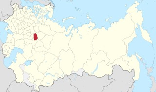
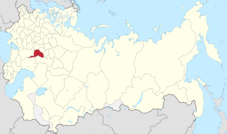
Location in the Russian Empire
Capital Nizhny Novgorod
Area 
 
51,252 km2 (19,789 sq mi)
Population 
 1897
1,584,774
History 
 Established
January 1714
 Disestablished
14 January 1929
Preceded by
Succeeded by
Coat of arms of Kazan Governorate 1856.svg Kazan Governorate
Coat of Arms of Nizhny Novgorod Uezd.svg Nizhegorodsky Uyezd
Nizhny Novgorod Oblast Flag of the Russian Soviet Federative Socialist Republic (1954-1991).svg
Map of Nizhny Novgorod Governorate. 1913 Nizhny Novgorod Governorate (1913).png
Map of Nizhny Novgorod Governorate. 1913

Nizhny Novgorod Governorate [lower-alpha 1] was an administrative-territorial unit ( guberniya ) of the Russian Empire, Russian Republic, and the Russian SFSR, roughly corresponding to the Upper and Middle Volga region and what is now most of the Nizhny Novgorod Oblast. In the early of 20th Century, Nizhny Novgorod Governorate bordered Kostroma and Vyatka governorates to the north, Vladimir Governorate to the west, Kazan and Simbirsk governorates to the east, and Penza with Tambov governorates to the south.

Contents

In the early 18th Century, Nizhny Novgorod Governorate was included in Kazan Governorate, from 1708–1714, and 1717–1719. The Reform of Peter the Great formed the newly governorate from 1714 to 1779. in the Reign of Catherine the Great, the governorate was reorganized to the Viceroyalty until 1796. In 1929 the governorate was disestablished, as a result of the new administrative reform, where the governorate was again reorganized to the Oblast. The governorate's administrative center was seated in Nizhny Novgorod and consisted of eleven uezds.

Geography

Nizhny Novgorod Governorate was bordered by the following governorates: the Vladimir Governorate to the west, Kostroma and Vyatka governorates to the north, Kazan and Simbirsk governorates to the east, and Penza and Tambov governorates to the south.

The area of the governorate was 48,421 km2 (18,695 sq mi) in 1847, 51,252 km2 (19,789 sq mi) in 1905, [1] and 81,458 km2 (31,451 sq mi) in 1926. [2]

The Oka and Volga rivers divided the governorate into two parts that differed significantly in relief, geological structure, soils, and vegetation: the northern was a lowland, and the southern was an upland.

History

Nizhny Novgorod Land in pre-Peter periods

Formation of the Governorate

In the course of the regional reform of Peter I in 1708, Nizhny Novgorod Governorate, was included in the Kazan Governorate. In January 1714, a new Nizhny Novgorod Governorate separated from the northwestern part of the Kazan Governorate. In addition to Nizhny Novgorod, including the cities of Alatyr, Arzamas, Balakhna, Vasilsursk, Gorokhovets, Kurmysh, Yuryevets, Yadrin with adjacent territories. In 1717, the Governorate was abolished, and the Governorate again merged with the Kazan Governorate.

On May 29, 1719, as a result of the Second Peter I's reform, the Nizhny Novgorod Governorate has recreated again. It included 3 provinces: Alatyr, Arzamas, Nizhny Novgorod, and 7 cities.

In the course of Catherine II's administrative reform on September 5, 1779, the Nizhny Novgorod Viceroyalty was established, which included the former Nizhny Novgorod Governorate, as well as parts of the previously formed Ryazan and Vladimir viceroyalties, and a part of the Kazan Governorate.

On December 12, 1796, under Paul I, the Nizhny Novgorod Viceroyalty was renamed a Governorate.

In October 1797, the area of the Nizhny Novgorod Governorate was increased at the expense of the territories received during the partition of the Penza Governorate. After the accession to the throne of Alexander I on September 9, 1801, the Penza Governorate was restored to its previous area.

In connection with the Zemstvo reform, in 1865, the institute of local government introduced the Zemstvo in the Nizhny Novgorod Governorate.

The Nizhny Novgorod Governorate was among the 17 regions recognized as seriously affected during the famine of 1891–1892.

After the October Revolution of 1917, the Nizhny Novgorod Governorate became part of the Russian Soviet Federative Socialist Republic (RSFSR) formed in 1918.

In 1922, the Governorate included the Varnavinsky and Vetluzhsky districts of the Kostroma Governorate, the Kurmyshsky district of the Simbirsk Governorate, and a small part of the Tambov Governorate.

By a decree of the Presidium of the All-Russian Central Executive Committee on January 14, 1929, the Governorates were completely abolished. On the territory of the Nizhny Novgorod Governorate, the Nizhny Novgorod Oblast was formed, which also included the territories of the abolished Vyatka Governorate and small sections of the Vladimir and Kostroma governorates. [3]

Subdivisions

Related Research Articles

<span class="mw-page-title-main">Nizhny Novgorod Oblast</span> First-level administrative division of Russia

Nizhny Novgorod Oblast is a federal subject of Russia. Its administrative center is the city of Nizhny Novgorod. It has a population of 3,119,115 as of the 2021 Census. From 1932 to 1990 it was known as Gorky Oblast.

<span class="mw-page-title-main">Sura (river)</span> River in Russia

The Sura is a river in Russia, a north-flowing right tributary of the Volga. Its mouth on the Volga is about half way between Nizhny Novgorod and Kazan. It flows through Penza Oblast, Mordovia, Ulyanovsk Oblast, Chuvashia and Nizhny Novgorod Oblast. It is 841 kilometres (523 mi) long, and has a drainage basin of 67,500 square kilometres (26,100 sq mi). It is navigable for 394 km from the mouth.

<span class="mw-page-title-main">History of the administrative division of Russia</span>

The modern administrative-territorial structure of Russia is a system of territorial organization which is a product of a centuries-long evolution and reforms.

<span class="mw-page-title-main">Kazan Governorate</span> 1708–1920 unit of Russia

Kazan Governorate was an administrative-territorial unit (guberniya) of the Tsardom of Russia, the Russian Empire, and the Russian SFSR from 1708 to 1920, with its capital in Kazan.

<span class="mw-page-title-main">Archangelgorod Governorate</span> 1708–1780 unit of Russia

Archangelgorod Governorate was an administrative-territorial unit (guberniya) of the Tsardom of Russia and the Russian Empire, which existed from 1708 until 1780. Its seat was in Archangel (Arkhangelsk). The governorate was located in the north of the Russian Empire and bordered Siberia Governorate in the east, Kazan Governorate in the southeast, Moscow and Ingermanland Governorates in the southwest, Sweden in the west, and Norway in north-west. In the north, the governorate was limited by the White and Barents Seas.

<span class="mw-page-title-main">Military districts of the Russian Empire</span> Type of administrative command of the Imperial Russian Army

In the Imperial Russian Army, a military district was a territorial association of military units, formations, military schools, and various local military establishments. This territorial division type was utilized to provide a more efficient management of army units, their training and other operations activities related to combat readiness.

<span class="mw-page-title-main">Kharkov Governorate</span> 1765–1925 unit of Russia

Kharkov Governorate was an administrative-territorial unit (guberniya) of the Russian Empire founded in 1835. It embraced the historical region of Sloboda Ukraine. From 1765 to 1780 and from 1796 to 1835 the governorate was called Sloboda Ukraine Governorate. In 1780–1796 there existed the Kharkov Viceroyalty.

<span class="mw-page-title-main">Novgorod Governorate</span> 1727–1927 unit of Russia

Novgorod Governorate was an administrative-territorial unit (guberniya) of the Russian Empire and the Russian SFSR, which existed from 1727 to 1776 and from 1796 to 1927. Its administrative center was in the city of Novgorod. The governorate was located in the northwest of the European part of the Russian Empire.

<span class="mw-page-title-main">Tambov Governorate</span> 1796–1928 unit of Russia

Tambov Governorate was an administrative-territorial unit (guberniya) of the Russian Empire, the Russian Republic, and the Russian SFSR, with its capital in Tambov. It was located between 51°14' and 55°6' north and between 38°9' and 43°38' east. It bordered Vladimir Governorate and Nizhny Novgorod Governorate to north, Penza Governorate and Saratov Governorate to the east, Voronezh Governorate to south and west, and Oryol Governorate, Tula Governorate, and Ryazan Governorate to the west.

<span class="mw-page-title-main">Vologda Governorate</span> 1796–1929 unit of Russia

Vologda Governorate, also known as the Government of Vologda, was an administrative-territorial unit (guberniya) of the Russian Empire and the Russian SFSR, which existed from 1796 until 1929. Its administrative center was in the city of Vologda.

<span class="mw-page-title-main">Vologda Viceroyalty</span> 1780–1796 unit of Russia

Vologda Viceroyalty was an administrative-territorial unit (namestnichestvo) of the Russian Empire, which existed in 1780–1796. The seat of the Viceroyalty was located in Vologda.

<span class="mw-page-title-main">Siberia Governorate</span> 1708–1782 unit of Russia

Siberia Governorate was an administrative-territorial unit (guberniya) of the Tsardom of Russia and the Russian Empire, which existed from 1708 until 1782. Its seat was in Tobolsk. The governorate was located in the east of Russian Empire and bordered China in the south, Kazan Governorate in the southwest, and Archangelgorod Governorate in the northwest. In the north and the east, the governorate was limited by the seas of the Arctic and Pacific Oceans. In terms of area, Siberia Governorate was by far the biggest of all the governorates, as it included areas in the Urals, Siberia, and the Russian Far East some of which were not yet even settled by Russians at the time.

<span class="mw-page-title-main">Vyatka Governorate</span> 1796–1929 unit of Russia

Vyatka Governorate was an administrative-territorial unit (guberniya) of the Russian Empire and the Russian SFSR from 1796 to 1929, with its capital in Vyatka. The area of the governorate roughly corresponds to modern-day Kirov Oblast and Udmurtia.

<span class="mw-page-title-main">Voronezh Governorate</span> 1725–1928 unit of Russia

Voronezh Governorate was an administrative-territorial unit (guberniya) of the Tsardom of Russia, the Russian Empire, and the Russian SFSR, which existed from 1708 to 1779 and again from 1796 to 1928. Its capital was located in Voronezh since 1725.

<span class="mw-page-title-main">Saratov Governorate</span> 1797–1928 unit of Russia

Saratov Governorate was an administrative-territorial unit (guberniya) of the Russian Empire and the Russian SFSR.

References

  1. "Тархов С.А. Изменение АТД России за последние 300 лет". Archived from the original on 2011-09-27. Retrieved 2010-10-13.
  2. "Всесоюзная перепись населения 1926 г."
  3. Постановление ВЦИК от 14.01.1929 «Об образовании на территории Р. С. Ф. С. Р. административно-территориальных объединений краевого и областного значения»
    • Russian: Нижегородская губерния, pre-1918: Нижегородская губернія, romanized: Nizhegorodskaya guberniya

56°19′37″N44°00′27″E / 56.3269°N 44.0075°E / 56.3269; 44.0075