North Atlantic weather war

Last updated
Weather Station Kurt, a German automated weather station. (shown here at the Canadian War Museum in 2007) Weather Station Kurt.JPG
Weather Station Kurt, a German automated weather station. (shown here at the Canadian War Museum in 2007)

The North Atlantic weather war occurred during World War II. The Allies (Britain in particular) and Germany tried to gain a monopoly on weather data in the North Atlantic and Arctic oceans. Meteorological intelligence was important as it affected military planning and the routing of ships and convoys. In some circumstances, visibility was necessary (photographic reconnaissance and bombing raids) and in others concealment (keeping ship movements secret or suppressing enemy air activity). D-day planning was greatly affected by weather forecasting; it was delayed by one day in the expectation that a storm would blow out and sea conditions would be acceptable. British sources of data included ships at sea and the weather stations at Valentia Observatory and Blacksod Point, in neutral Ireland; German use of weather ships also exposed their secret Enigma codes.

Contents

Ocean weather vessels

In 1939, United States Coast Guard vessels were being used as weather ships to protect transatlantic air commerce. [1] The Atlantic Weather Observation Service was authorized by President Franklin Delano Roosevelt on January 25, 1940. [2] By February 1941, five 327 ft (100 m) Coast Guard cutters were used in weather patrol, usually deployed for three weeks at a time, then sent back to port for ten days. As World War II continued, cutters were needed for the war effort and by August 1942, six cargo vessels were used. The ships were modified with guns and depth charge projectors, and crews were trained and regularly drilled in gunnery but the former cargo ships had top speeds of 10-12 knots, significantly less than U-Boats, which could reach 16 knots on the surface. [3] USCGC Muskeget was torpedoed with 121 aboard on September 9, 1942. In 1943, the United States Weather Bureau recognized their observations as "indispensable" for the war effort. [1]

The flying of fighter aircraft between North America, Greenland and Iceland led to the deployment of two more weather ships in 1943 and 1944. The United Kingdom established one 80 km (50 mi) off the west coast of Britain. By May 1945, sixteen ships were in use north of the 15th parallel north in the Atlantic, with six more in the tropical Atlantic. Twenty United States Navy frigates were used in the Pacific for similar operations. Weather Bureau personnel stationed on weather ships were asked voluntarily to accept the assignment. They used surface weather observations, radiosondes and pilot balloons (PIBALs) to determine weather conditions aloft. Due to its value, operations continued after World War II, leading to an international agreement in September 1946 that no fewer than 13 ocean weather stations would be maintained by the Coast Guard, with five others maintained by Great Britain and two by Brazil. [1]

The Germans began to use weather ships in the summer of 1940 but three of its four ships were sunk by November 23, which led to the use of fishing vessels for its weather ship fleet. German weather ships were out to sea for three to five weeks at a time and would have Enigma machine and codes for several months to send weather observations in cypher. [4] Their radio reports exposed their location to the superior British High-frequency direction finding system and their encryption provided additional fodder for British cryptanalysts.

Harry Hinsley worked on plans to seize Enigma machines and keys from the German weather ships, to help Bletchley Park to resume their cryptanalysis of the Enigma Navy version, as the inability to decode the new M4 "shark" cypher was seriously affecting the Battle of the Atlantic. Munchen and Lauenburg were boarded by the Royal Navy, who managed to gather valuable information on German codes in each case. Wuppertal became trapped in ice and was lost without trace of ship or crew. [5]

Land stations

The Germans made attempts to set up land-based weather stations in contested locations such as Spitsbergen and even on Allied-held shores, such as the automated Weather Station Kurt in Labrador. The Germans were obliged, by their continental location, to rely largely on long-range aircraft and weather ships—which were vulnerable to attack—and on clandestine stations in exposed locations. The Allies had a distinct advantage in the contest, controlling all of the major islands (Newfoundland, Greenland, Iceland, Great Britain) of the North Atlantic. As weather patterns at that latitude generally travel west to east, the Allies could follow the progress of a front as it traveled across the Atlantic. The Germans, with their small number of (impermanent) observation stations, had to rely on a certain amount of luck to detect a weather front before it reached Europe.

In August 1941, in the preparation for Operation Gauntlet (the occupation of Spitsbergen), the Royal Navy destroyed the weather station on Bear Island and later, one on Spitsbergen (after it had transmitted false information to discourage air observation). Spitsbergen was an important location: it enabled the Germans to monitor weather conditions on the Allied convoy route to northern Russia. The Germans made several attempts to establish and maintain weather stations in the Svalbard archipelago including Spitsbergen and Hopen (Hope Island: stations Svartisen and Helhus) and these were never suppressed. Other locations used included those on Jan Mayen Island, Bear Island (Taaget  [ de ], 1944–1945) and eastern Greenland with teams and automated stations. The Kriegsmarine operated the manned Schatzgräber station on Alexandra Land in the Soviet Franz Josef Land archipelago from November 1943 to July 1944.

Air meteorological patrols

The RAF operated 518 Squadron from RAF Tiree in the Scottish Hebrides, 519 Squadron from RAF Wick and RAF Skitten in Caithness, Scotland and 517 Squadron from RAF Brawdy, in south-west Wales, to fly meteorological sorties into the Atlantic. Flying standard patrol patterns, Handley Page Halifaxes, Lockheed Hudsons and Boeing B-17 Flying Fortresses and other aircraft made meteorological readings at various heights from 50 ft (15 m) to their ceiling of 18,000 ft (5,500 m), at prescribed points along the patrols. The patrols were long (up to 11+12 hours); in often poor weather and sometimes dangerous, at least ten aircraft from 518 Squadron were lost with all hands during 1944. Meteorological reports from air patrols influenced the timing of D-Day. The critical patrol experienced severe weather conditions and its crew's reports were so extreme that they were not to be believed at first. A similar patrol from Brawdy reported similarly bad conditions but was lost with its crew. [6]

The historical novel Turbulence by Giles Foden portrays the efforts of James Stagg, Lewis Fry Richardson (fictionalised as Wallace Ryman) and others to predict the weather ahead of the D-Day landings. The play Pressure by David Haig is a fictional version of the 72-hours leading up to D-day revolving around the arguments between James Stagg, Irving P. Krick and Dwight Eisenhower.

See also

Notes

Citations

  1. 1 2 3 Willoughby 1980, pp. 127–130.
  2. WBT 1952, p. 61.
  3. "Miscellaneous (AG) Photo Index". www.navsource.org. Retrieved 2021-03-05.
  4. Khan 2001, pp. 149–152.
  5. Sebag-Montefiore 2001, pp. 144–148, 167–171.
  6. Pringle 2003.

Related Research Articles

<span class="mw-page-title-main">Jan Mayen</span> Norwegian island in the Arctic Ocean

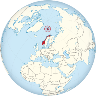
Jan Mayen is a Norwegian volcanic island in the Arctic Ocean with no permanent population. It is 55 km (34 mi) long (southwest-northeast) and 373 km2 (144 sq mi) in area, partly covered by glaciers. It has two parts: larger northeast Nord-Jan and smaller Sør-Jan, linked by a 2.5 km (1.6 mi) wide isthmus. It lies 600 km (370 mi) northeast of Iceland, 500 km (310 mi) east of central Greenland, and 900 km (560 mi) northwest of Vesterålen, Norway.

<span class="mw-page-title-main">Battle of the Atlantic</span> Attempt by Germany during World War II to cut supply lines to Britain

The Battle of the Atlantic, the longest continuous military campaign in World War II, ran from 1939 to the defeat of Nazi Germany in 1945, covering a major part of the naval history of World War II. At its core was the Allied naval blockade of Germany, announced the day after the declaration of war, and Germany's subsequent counter-blockade. The campaign peaked from mid-1940 through to the end of 1943.

<span class="mw-page-title-main">811 Naval Air Squadron</span> Military unit

811 Naval Air Squadron was a unit of the British Royal Navy's Fleet Air Arm. It was first founded in 1933, and served during World War II, seeing action in the battle of the Atlantic and on Russian convoys, and was eventually disbanded in 1956.

<span class="mw-page-title-main">Weather ship</span> Ship used to aid weather forecasting

A weather ship, or ocean station vessel, was a ship stationed in the ocean for surface and upper air meteorological observations for use in weather forecasting. They were primarily located in the north Atlantic and north Pacific oceans, reporting via radio. The vessels aided in search and rescue operations, supported transatlantic flights, acted as research platforms for oceanographers, monitored marine pollution, and aided weather forecasting by weather forecasters and in computerized atmospheric models. Research vessels remain heavily used in oceanography, including physical oceanography and the integration of meteorological and climatological data in Earth system science.

<span class="mw-page-title-main">Weather Station Kurt</span> Nazi German automatic weather station in Canada

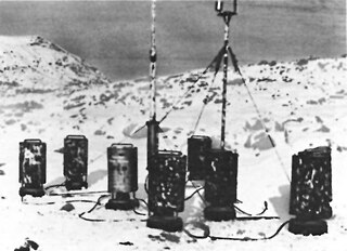
Weather Station Kurt was an automatic weather station, erected by a German U-boat crew of the Kriegsmarine in northern Labrador, Dominion of Newfoundland, in October 1943. Installing the equipment for the station was the only known armed German military operation on land in North America during the Second World War. After the war, it was forgotten until its rediscovery in 1977.

<span class="mw-page-title-main">RAF Brawdy</span> Former Royal Air Force station in Pembrokeshire, Wales

Royal Air Force Brawdy, or more simply RAF Brawdy, is a former Royal Air Force satellite station located 6.3 miles (10.1 km) east of St Davids, Pembrokeshire and 9.8 miles (15.8 km) south west of Fishguard, Pembrokeshire, Wales. It was operational between 1944 and 1992; it was used by the Royal Air Force and the Royal Navy (1946–1971), before the site was turned over to the British Army and renamed Cawdor Barracks.

USCGC <i>Modoc</i>

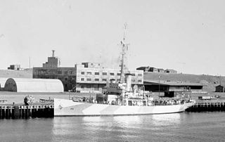
USCGC Modoc (WPG-46) was a 240-foot Tampa-class United States Coast Guard cutter designed for multi-mission roles. She had a top speed of sixteen knots, and was armed with a pair of 5-inch deck guns. With the breakout of war she was armed with depth charges, additional guns, sonar, and radar and transferred to the Navy. Modoc, along with her sister ships Mojave and Tampa joined the Greenland Patrol.

<span class="mw-page-title-main">RAF St Eval</span> Former RAF base in Cornwall, England

Royal Air Force St. Eval or RAF St. Eval was a Royal Air Force station for the RAF Coastal Command, southwest of Padstow in Cornwall, England, UK. St Eval's primary role was to provide anti-submarine and anti-shipping patrols off the south west coast. Aircraft from the airfield were also used for photographic reconnaissance missions, meteorological flights, convoy patrols, air-sea rescue missions and protection of the airfield from the Luftwaffe.

<span class="mw-page-title-main">Greenland in World War II</span> History of Greenland during World War II

The fall of Denmark in April 1940 left the Danish colony of Greenland an unoccupied territory of an occupied nation, under the possibility of seizure by the United Kingdom, United States or Canada. To forestall this, the United States acted to guarantee Greenland's position. With the entrance of the United States into the war in December 1941, Greenland became a combatant.

<span class="mw-page-title-main">Operation Haudegen</span> German operation during World War 2

Operation Haudegen was the name of a German operation during the Second World War to establish meteorological stations on the Svalbard archipelago in Norway. In September 1944, the submarine U-307 and the supply ship Carl J. Busch transported the men of Unternehmen Haudegen to the island. The station was active from 9 September 1944. On May 8, 1945, the staff received a message from their commanders in Tromsø that Germany had surrendered and the war was over. After that, radio contact was lost. The soldiers were capable of asking for support only in August 1945 and on 6 September, were picked up by a Norwegian seal hunting vessel and surrendered to its captain. The group of men were the last German troops to surrender after the Second World War.

<span class="mw-page-title-main">No. 518 Squadron RAF</span> Defunct flying squadron of the Royal Air Force

No. 518 Squadron RAF was a meteorological squadron of the Royal Air Force during the Second World War. The weather observations they collected helped inform Group Captain James Martin Stagg's recommendation to General Dwight D. Eisenhower to delay the launching of the D-Day invasion of Normandy from 5 June to 6 June 1944.

<span class="mw-page-title-main">Northeast Air Command</span> Former U.S. Air Force major command

Northeast Air Command (NEAC) was a Major Command of the United States Air Force, responsible for the operation and defense of air bases in Greenland, Labrador, and Newfoundland. It was formed in 1950 from the facilities of the United States established during World War II in eastern Canada, Newfoundland and Greenland. It was discontinued in 1957.

<span class="mw-page-title-main">Operation Fritham</span> Allied military operation during WW2 to secure the coal mines on Spitsbergen in 1942

Operation Fritham was an Allied military operation during the Second World War to secure the coal mines on Spitsbergen, the main island of the Svalbard Archipelago, 650 mi (1,050 km) from the North Pole and about the same distance from Norway. The operation was intended to deny the islands to Nazi Germany.

<span class="mw-page-title-main">Bluie East Two</span> Airport in Ikateq Fjord, Greenland

Bluie East Two was a minor United States Army Air Forces airfield at Ikateq in eastern Greenland. It was operational from 1942 to 1947.

<span class="mw-page-title-main">RAF St Davids</span> Former Royal Air Force station in Pembrokeshire, Wales

Royal Air Force St Davids, or more simply RAF St Davids, is a former Royal Air Force station, near the city of St Davids, Pembrokeshire, Wales, in the community of Solva.

<span class="mw-page-title-main">Greenland Patrol</span>

The Greenland Patrol was a United States Coast Guard operation during World War II. The patrol was formed to support the U.S. Army building aerodrome facilities in Greenland for ferrying aircraft to the British Isles, and to defend Greenland with special attention to preventing German operations in the northeast. Coast Guard cutters were assisted by aircraft and dog sled teams patrolling the Greenland coast for Axis military activities. The patrol escorted Allied shipping to and from Greenland, built navigation and communication facilities, and provided rescue and weather ship services in the area from 1941 through 1945.

<span class="mw-page-title-main">Operation Orator</span>

Operation Orator was the code name for the defence of the Allied Arctic convoy PQ 18 by British and Australian air force units, based temporarily in North-West Russia, against attack by the German battleship Tirpitz and other Kriegsmarine surface vessels. The wing, known as the Search & Strike Force, was commanded by Group Captain Frank Hopps and its maritime strike element was the Leuchars Wing, comprising No. 144 Squadron, Royal Air Force (RAF) and No. 455 Squadron, Royal Australian Air Force (RAAF) equipped with Handley-Page Hampden TB 1 torpedo bombers.

<span class="mw-page-title-main">1st Weather Reconnaissance Squadron</span> Military unit

The 1st Weather Reconnaissance Squadron is an inactive United States Army Air Force unit. It saw service between April 1943 and May 1945. On 21 December the squadron was inactivated at Grenier Field, New Hampshire.

<span class="mw-page-title-main">Operation Gearbox</span> Norwegian & British operation to occupy the Arctic island of Spitsbergen during WW2 in 1942

Operation Gearbox was a joint Norwegian and British operation to occupy the Arctic island of Spitsbergen during the Second World War. It superseded Operation Fritham, an expedition in May, to secure the coal mines on Spitsbergen, the main island of the Svalbard Archipelago which had failed when attacked by four German Focke-Wulf Fw 200 Condor reconnaissance bombers. The Norwegian force, with 116 long tons (118 t) of supplies, arrived by British cruiser on 2 July.

<span class="mw-page-title-main">Operation Gearbox II</span>

Operation Gearbox II was a Norwegian and British operation during the Second World War on the Arctic island of Spitsbergen in the Svalbard Archipelago. Operation Fritham, the first attempt to establish a base had been defeated when the two ships carrying the force were sunk by Luftwaffe bombers on 14 May.

References

Further reading