
Fenwick is a borough in Middlesex County, Connecticut, United States, in the town of Old Saybrook. The population was 52 at the 2000 census, making it the least populous borough in Connecticut. It is a popular summer colony. Most of the borough is included in Fenwick Historic District, a historic district listed on the National Register of Historic Places. In 1995, the district included 66 contributing buildings and one other contributing site.

Jordan is a village in the town of Waterford, Connecticut, and the historic center of the town. It was named from the Jordan River. The village was listed on the National Register of Historic Places as Jordan Village Historic District in 1990.
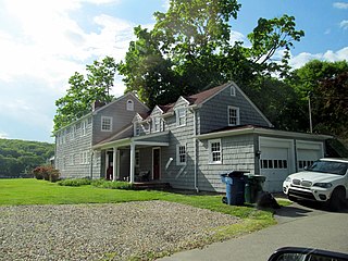
The Oswegatchie Historic District is a historic district in the town of Waterford, Connecticut, United States. The historic district is located on a peninsula on the east side of the tidal Niantic River, and represents a cross-section of historic coastal land uses, from farming to a small colony of summer estates to year-round living. The district was listed on the National Register of Historic Places in 2005.
Cypress Cemetery is an historic cemetery at 100 College Street in Old Saybrook, Connecticut. Established sometime in the 17th century, and still in active use, it is the town's oldest cemetery, with a wide variety of funerary art dating from the 17th to 21st centuries. The cemetery's oldest portion was listed on the National Register of Historic Places in 2018.

The Beaver Hills Historic District is a 97-acre (39 ha) historic district in the Beaver Hills neighborhood of New Haven, Connecticut. It was listed on the National Register of Historic Places in 1986. In 1986, it included 235 contributing buildings.

The Compo–Owenoke Historic District is a 154-acre (62 ha) historic district in Westport, Connecticut that was listed on the National Register of Historic Places in 1991. It was described as being "architecturally significant as an exceptionally well-preserved and cohesive early-twentieth-century beach colony which developed between 1910 and 1940."
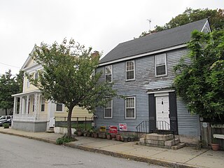
The Coit Street Historic District in New London, Connecticut is a historic district that was listed on the National Register of Historic Places in 1988. It includes 33 contributing buildings over a 4 acres (1.6 ha) area, located just southwest of the city's central business district. The area included in the district was formerly known as Bream Cove, which was filled in and developed in the 19th century. The area includes four out of twelve surviving 18th-century buildings in the city. It includes all of the properties on Coit and Brewer Streets, as well as those on Blinman Street between those two streets.

The Connecticut Valley Railroad Roundhouse and Turntable Site is a former railroad facility located in Fort Saybrook Monument Park off Main Street in Old Saybrook, Connecticut. The roundhouse and turntable were built in 1871 by the Connecticut Valley Railroad, which was later acquired by the New York, New Haven and Hartford Railroad. The rail facilities are built partly on the archaeological remains of Fort Saybrook, the main fortification of the 17th-century Saybrook Colony, and are the only surviving remnant of what was once a large facility, with an icehouse, coal bin, steamboat dock, depot, and signal tower. Archaeological remains of these other facilities are believed to lie under other parts of the park and adjacent properties. The exposed facilities were excavated in 1981-2. Both structures were added to the National Register of Historic Places on April 28, 1994.
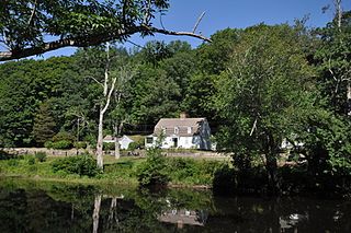
The Hamburg Bridge Historic District is located in Lyme, Connecticut. It encompasses a small village which was of economic importance until about 1824, as the site of a bridge across the Eight Mile River since 1759, and as the head of navigation of the river, which feeds the Connecticut River at Hamburg Cove. The district includes 10 houses, all of which are historically significant, as well as old stone wharves dating to the period. The district was added to the National Register of Historic Places on March 10, 1983.
The Fourth Ward Historic District encompasses an early urban residential subdivision of Greenwich, Connecticut. Extending north from United States Route 1 along Sherwood Place, Church Street, and adjacent streets, it is one of two subdivisions created before the arrival of the railroad in Greenwich in 1848. It is characterized by dense residential construction, with architectural styles from the Greek Revival to early 20th-century styles. The district was listed on the National Register of Historic Places in 2000.

The Captain Enoch Lord House, also known as Red House, is a historic house at 17 Tantummaheag Road in Old Lyme, Connecticut. Built about 1748, the house is significant both for its long historic association with the colonial Lord family, who were influential participants in the founding of both the Connecticut Colony and the Saybrook Colony, and for its transformation in the late 19th century into a summer estate. The house was listed on the National Register of Historic Places in 2007.

The Strickland Road Historic District of Greenwich, Connecticut is a 9-acre (3.6 ha) historic district that was listed on the U.S. National Register of Historic Places in 1990. The district extends along Strickland Road in the Cos Cob section of Greenwich, between its junction River Road in the south, to just north of its junction with Loughlin Road in the north. It represents a well-preserved cross-section of residential architecture dating coverint a 200-year period, from about 1740 to 1934. It includes the c. 1730 Bush-Holley House, a historic house museum which is a National Historic Landmark for it role in the Cos Cob art colony. There are 28 primary contributing buildings in the district. Most of the buildings are wood frame structures between one and three stories in height; the notable exceptions are two of the later houses, which are Tudor Revival in style and have brick and stucco exteriors.
The Middletown Upper Houses Historic District, also known as the Upper Houses River Port, encompasses the historic early nucleus of Cromwell, Connecticut. Sandwiched between Main Street and the Connecticut River, this area was set off from neighboring Middletown in 1851. It is visually dominated by residential structures built before 1810. The area grew as a significant river port and shipbuilding center until the mid-19th century. The district was listed on the National Register of Historic Places in 1979.

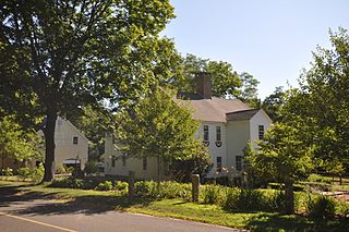
The Old Saybrook South Green is a 20-acre (8.1 ha) historic district that encompasses the historic town green and nearby streets in Old Saybrook, Connecticut. Established in the 1630s, most of the buildings arrayed around the green were built between 1760 and 1900, and reflect the prosperity of the town, which was a major port and shipbuilding center. The district was listed on the National Register of Historic Places in 1976.
The Samuel Eliot House is a historic house at 500 Main Street in Old Saybrook, Connecticut. Probably built in 1737, it is a well-preserved example of Georgian residential architecture, and one of Old Saybrook's older buildings. The house was listed on the National Register of Historic Places in 1972.

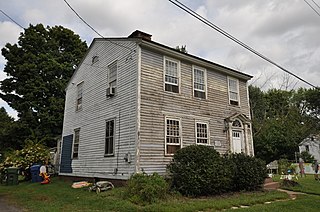
The Jedidiah Dudley House, is a historic house on Springbrook Road in Old Saybrook, Connecticut. Built in the second half of the 18th century, it is a good example of period architecture, and is notable for its association with a family of ferry operators on the nearby Connecticut River. It was listed on the National Register of Historic Places in 1982.

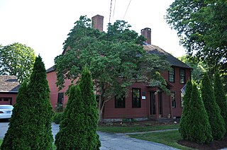
The Gen. William Hart House is a historic house at 350 Main Street in Old Saybrook, Connecticut. Built in 1767 for a politician and colonial militia leader, it is a good example of Georgian residential architecture. The house was listed on the National Register of Historic Places in 1972, and is a contributing property to the Old Saybrook South Green historic district.
The Old Lyme Historic District encompasses the historic village center of Old Lyme, Connecticut. Located mainly on Lyme Street south of Interstate 95, the village, settled in the mid-17th century, has an architectural history dating to the early 18th century, flourishing as a shipbuilding center and home to many ship captains. It was listed on the National Register of Historic Places in 1971.


