North Fork, California

Last updated

North Fork
wa?ahhpY'
California Locator Map with US.PNG
Red pog.svg
North Fork
Usa edcp location map.svg
Red pog.svg
North Fork
Coordinates: 37°13′47″N119°30′34″W / 37.22972°N 119.50944°W / 37.22972; -119.50944
Country United States
State California
County Madera
Area
[1]
  Total32.28 sq mi (83.6 km2)
  Land32.24 sq mi (83.5 km2)
  Water0.04 sq mi (0.1 km2)
Elevation
[2]
2,638 ft (804 m)
Population
 (2020) [3]
  Total3,250
  Density100.8/sq mi (38.9/km2)
Time zone UTC-8 (Pacific (PST))
  Summer (DST) UTC-7 (PDT)
ZIP Code
93643
Area code 559
GNIS feature IDs1659768; [2] 2804436 [4]
FIPS Code 06-51868

North Fork (formerly Brown's and Northfork; Mono wa?ahhpY', "cedar grove") [5] is an unincorporated community in Madera County, California, United States. [2] As of the 2020 United States census it had a population of 3,250. [3] For statistical purposes, the United States Census Bureau has defined North Fork as a census-designated place (CDP). North Fork is part of the Madera Metropolitan Statistical Area and is home to the tribal headquarters of the Northfork Rancheria of Mono Indians of California.

Contents

North Fork is situated in the Sierra Nevada foothills at an elevation of 2,638 feet. It is roughly 46 miles (74 km) miles north-northeast of Fresno, 41 miles (66 km) miles northeast of Madera, and 17 miles (27 km) miles southeast of Oakhurst by road. The CDP has a total area of 32.3 square miles (84 km2) square miles, with Willow Creek, North Fork, and South Fork serving as its primary bodies of water. North Fork also holds the distinction of being the community closest to the geographic center of California.

North Fork is within the ancestral home of the Mono Native Americans. The community developed into a significant hub for the timber industry, which was the mainstay of the local economy until the late 20th century.

Attractions in North Fork include the Sierra Mono Museum and the Sierra Vista Scenic Byway. The Buckhorn Saloon, a mainstay since the 1800s, continues to function as a restaurant and tavern. North Fork is also the site of the annual Mid-Sierra Loggers Jamboree, a tribute to the region's logging history.

Geography

CA geographic center monument.jpg

North Fork is located in the foothills of the Sierra Nevada at an elevation of 2,638 feet (804 m). [2] It is 46 miles (74 km) north-northeast of Fresno, 41 miles (66 km) northeast of Madera, and 17 miles (27 km) by road southeast of Oakhurst. According to the U.S. Census Bureau, the North Fork CDP has a total area of 32.3 square miles (84 km2), of which 0.04 square miles (0.10 km2), or 0.14%, are water. [1] The community is drained by Willow Creek and by its North Fork and South Fork. Willow Creek is a south-flowing tributary of the San Joaquin River.

The geographic center or midpoint of the state of California is located between North Fork and Italian Bar. The point is about 7.1 miles (11.4 km) driving distance from the United States Forest Service office in North Fork. The location is marked by a sign and a survey marker. The site has wooden stairs leading up the hillside about 50 feet from the road. The marker is not wheelchair accessible.

Climate

North Fork has a Mediterranean climate (Köppen Cfa) with cool, rainy winters and hot, dry summers. Its average annual precipitation is 33.43 in (849 mm). [6] Its hardiness zone is 7b. [7]

North Fork (1981-2010 Normals)
Climate chart (explanation)
J
F
M
A
M
J
J
A
S
O
N
D
 
 
6.8
 
 
57
30
 
 
6.1
 
 
59
30
 
 
5.4
 
 
63
35
 
 
2.4
 
 
69
38
 
 
1.5
 
 
78
45
 
 
0.4
 
 
87
52
 
 
0.1
 
 
95
58
 
 
0.1
 
 
95
57
 
 
0.5
 
 
89
52
 
 
1.8
 
 
78
43
 
 
3.6
 
 
65
36
 
 
4.9
 
 
57
31
Average max. and min. temperatures in °F
Precipitation totals in inches
Source: Western Regional Climate Center [6]
Metric conversion
J
F
M
A
M
J
J
A
S
O
N
D
 
 
171
 
 
14
−1
 
 
155
 
 
15
−1
 
 
137
 
 
17
2
 
 
60
 
 
20
4
 
 
37
 
 
25
7
 
 
11
 
 
31
11
 
 
3
 
 
35
14
 
 
1.5
 
 
35
14
 
 
12
 
 
32
11
 
 
47
 
 
25
6
 
 
90
 
 
18
2
 
 
124
 
 
14
0
Average max. and min. temperatures in °C
Precipitation totals in mm
Climate data for North Fork RS, California (1945–2023 normals, [lower-alpha 1] extremes 1904–present)
MonthJanFebMarAprMayJunJulAugSepOctNovDecYear
Record high °F (°C)86
(30)
89
(32)
92
(33)
98
(37)
103
(39)
108
(42)
112
(44)
111
(44)
110
(43)
102
(39)
90
(32)
86
(30)
112
(44)
Mean maximum °F (°C)70
(21)
72
(22)
74
(23)
81
(27)
90
(32)
99
(37)
103
(39)
102
(39)
99
(37)
91
(33)
79
(26)
72
(22)
104
(40)
Mean daily maximum °F (°C)55.1
(12.8)
56.7
(13.7)
60.5
(15.8)
65.2
(18.4)
74.1
(23.4)
85.2
(29.6)
94.0
(34.4)
93.3
(34.1)
87.4
(30.8)
76.8
(24.9)
63.3
(17.4)
58.3
(14.6)
76.7
(24.8)
Daily mean °F (°C)42.2
(5.7)
45.1
(7.3)
47.8
(8.8)
51.8
(11.0)
59.1
(15.1)
67.8
(19.9)
75.6
(24.2)
75.0
(23.9)
69.6
(20.9)
60.4
(15.8)
50.1
(10.1)
45.1
(7.3)
62.3
(16.8)
Mean daily minimum °F (°C)30.0
(−1.1)
32.7
(0.4)
34.8
(1.6)
38.4
(3.6)
44.1
(6.7)
50.7
(10.4)
57.3
(14.1)
56.6
(13.7)
51.7
(10.9)
43.8
(6.6)
36.4
(2.4)
31.6
(−0.2)
42.3
(5.8)
Mean minimum °F (°C)20
(−7)
22
(−6)
25
(−4)
28
(−2)
33
(1)
39
(4)
49
(9)
48
(9)
41
(5)
33
(1)
26
(−3)
21
(−6)
17
(−8)
Record low °F (°C)5
(−15)
10
(−12)
15
(−9)
19
(−7)
26
(−3)
30
(−1)
31
(−1)
38
(3)
29
(−2)
19
(−7)
14
(−10)
4
(−16)
4
(−16)
Average precipitation inches (mm)6.70
(170)
5.71
(145)
5.61
(142)
2.81
(71)
1.41
(36)
0.36
(9.1)
0.08
(2.0)
0.06
(1.5)
0.57
(14)
1.51
(38)
3.16
(80)
5.36
(136)
33.34
(844.6)
Average snowfall inches (cm)4.6
(12)
2.1
(5.3)
2.0
(5.1)
0.4
(1.0)
0.0
(0.0)
0.0
(0.0)
0.0
(0.0)
0.0
(0.0)
0.0
(0.0)
0.0
(0.0)
0.4
(1.0)
1.8
(4.6)
11.3
(29)
Source: NOAA [8]

Demographics

North Fork, a census-designated place in California, has a notably older demographic compared to the state average, with a median age of 58 years compared to California's 37.9. A significant portion, 36.2%, of the local population is aged 65 and over, which is more than double the state's 15.8%, highlighting the area's aging population. Additionally, 18.6% of North Fork residents are disabled, surpassing the state's 11.7%, aligning with the community's older demographic. [9]

The community also has a higher percentage of veterans at 13%, compared to the California average of 4.3%, indicating a considerable number of residents with military backgrounds. [9]

Financially, North Fork's median household income is $65,850, below California's $91,551, and the area has a higher poverty rate of 15.7%, against the state's 12.2%. Educational levels are lower as well, with only 17.9% holding a bachelor's degree or higher, significantly less than the state's 37%. [9]

In terms of housing, North Fork is more affordable, with a median gross rent of $981, compared to the state's $1,870, and it has a total of 1,633 housing units. [9]

Demographically, the community comprises 356 American Indians, 385 Hispanic or Latinos, and 352 individuals of two or more races, with a majority of 2,388 identifying as White. The area has a smaller foreign-born population, making up only 5.2% of its residents, compared to California's 26.7%. [9]

History

Native People

Mono couple living near Northfork, California, ca. 1920 Photograph with text of a Mono couple living near Northfork, California. This is from a survey report of Fresno and... - NARA - 296289 (cropped).jpg
Mono couple living near Northfork, California, ca. 1920

North Fork is within the ancestral home lands of the Mono people, who still constitute a significant portion of the population (9.4% according to the 2000 Census).

The Sierra Timber Reserve Act, enacted in February 1893, resulted in the land around North Fork coming under federal control. This left the Mono Indians, who were not recognized as US citizens until 1924, left out. They were unable to pursue their traditional way of life or maintain their newly adopted practice of cattle grazing, finding themselves effectively excluded from their ancestral lands. Faced with these obstacles, many Mono Indians either assimilated into the settler community or dispersed to other areas. [10] :122

Early History

The first permanent community was established as a remote mountain outpost in 1865 when Milton Brown built what is believed to be the first house in the area — a log cabin at the end of a newly-developed wagon road leading from Crane Valley to the north fork of the San Joaquin River. Serving as a supply point, Brown catered to stockmen, sheepmen, and miners who left their wagons under his care while venturing further into the mountains. Consequently, the location was often referred to as "Brown's Place." [10] :115–117

A significant shift in the settlement's trajectory occurred in 1886 with the establishment of a sawmill on Peckinpah Mountain by Milton Brown and his partner, John Bartram. This venture marked the foundation of the North Fork Lumber Company, which would play a pivotal role in the community's evolution. By 1887, the company had established a post office under the name North Fork, subsequently bestowing the settlement with its present-day name. [11]

The small settlement, comprising mainly a handful of stores, hotels, and a watering trough, was primarily inhabited by miners and hog stockmen. Contemporary accounts note that the main store offered "a few groceries, cheap calico, and lots of whiskey," a selection that influenced locals to rename Alder Creek to Whiskey Creek, reflecting the area's reputation. [12] The Fresno Morning Republican once described the area as "a bleak little mountain center," emphasizing its isolation from valley towns such as Friant and Madera. [13]

Sam Peckinpah, the renowned director, drew inspiration from his youth spent on his grandparents' ranch in North Fork. His grandparents, Mr. and Mrs. Charles M. Peckinpah, settled in North Fork in 1884, and the name "Peckinpah Mountain" pays homage to their former sawmill site. [14] Peckinpah, born in 1925, channeled his family's experiences during the Wild West period into his Western films and TV series, including Ride the High Country (1962) and The Wild Bunch (1969). The town of North Fork in The Rifleman TV series, which Peckinpah created, is named after the real-life North Fork. [15]

Forestry

In 1902, North Fork became the pivotal hub for the Sierra Reserves, which later evolved into today's Sierra National Forest, when Charles H. Shinn became the head ranger. North Fork's central geographical location, nestled within the expansive territory of the Sierra Reserves that stretched from Tuolumne County in the north to Kern County in the south, made it an ideal choice for the organization's headquarters. [13] :18 The supervisor's office held a steady presence in North Fork, acting as the heart of the reserves, until it was eventually moved to Clovis in 1989. [13] :168

Lumber Industry

During the Great Depression, commercial logging in eastern Madera County came to a sudden stop, leading to the end of logging railroads. The Sugar Pine Lumber Company, operating in the mountains above North Fork, shut down in 1933. [16]

In 1941, the Associated Box and Lumber Company purchased 135 acres (55 ha) of land and moved its operations from Bieber to North Fork by 1942. This relocation marked a significant change for the town, starting a new logging era that lasted over fifty years. The introduction of logging trucks and modern equipment allowed deeper access into the Sierra National Forest, increasing the industry's reach and efficiency.

Although the sawmill and logging roads were not fully developed, operations began in 1942. By April 1, 1943, the mill processed its first log into lumber. In its first year, the North Fork mill processed over nine million board feet of lumber, mainly from ponderosa pine, sugar pine, lodgepole pine, and incense cedar in the Sierra National Forest.

The establishment of the mill significantly transformed North Fork. By 1951, the population surged to over 2,000 people. [17] The mill emerged as a major employer, offering jobs to over 130 workers at peak times and contributing about $500,000 to the local economy annually. [18] Despite this economic boost, North Fork did not have a bank. [19]

The mill complex featured a sawmill, planing mill, lumber storage, workshops, and housing for employees. [20] These accommodations included twenty-two two-bedroom houses available for rent. By 1968, the mill's annual payroll increased to $1,250,000, highlighting the logging industry's importance to the area.

In 1985, Ron Yanke acquired the mill, renaming it South Fork Timber Industries. From 1985 to 1991, the mill averaged an annual output of 143 million board feet of lumber, sufficient to build around 12,000 single-family homes. [21] [22]

A cogeneration plant was added in 1986, utilizing sawdust to power boilers and generate electricity, with surplus electricity sold to utilities. The mill also began converting bark into humus and selling ash as fertilizer. [21]

However, new government regulations by 1992 reduced forest yields significantly, dropping to 63.8 million board feet by 1993. These changes, along with rising costs, made lumber production unprofitable, leading to layoffs starting in 1991 and the mill's closure on February 25, 1994. [21]

Economy

Until 1996, the timber industry was the backbone of North Fork's economy, with the local lumber mill serving as the town's main source of livelihood. [23]

Employment in North Fork is distinct, with 20.9% of its workforce employed in local, state, and federal government roles, a proportion that surpasses California's 14.2%. However, the overall employment rate in North Fork stands at 34.3%, significantly lower than the state’s 60.0%. [9]

The US Forest Service Crane Valley Hotshots, a crew of wildland firefighters, remain based in North Fork. [24]

Arts and culture

The Sierra Mono Museum showcases the local history and culture. [25] The town also serves as the starting point for the Sierra Vista Scenic Byway, a route known for its stunning views of the Sierra Nevada. [26]

The Buckhorn Saloon. Buckhorn Saloon North Fork.jpg
The Buckhorn Saloon.

The Buckhorn Saloon, a fixture since the late 1800s, evolved into a dude ranch in the 1950s. It catered to fishing and hunting parties during their respective seasons, as well as local loggers. [27] Known for its rough-and-tumble patrons, it's proprietor was jailed for six months in the 1950s for firing a .45 caliber pistol at a patron. [28] [29] Today, it continues to operate as a restaurant and western saloon.

A historical marker, established by E Clampus Vitus, signifies the location of the stagecoach stop in the downtown area. [30] The geographical center of the state of California resides between North Fork and Italian Bar. The exact center, marked by a sign and a survey marker, is approximately 7.1 miles (11.4 km) driving distance from the United States Forest Service office in North Fork. [31]

Initiated in 1959, the North Fork Loggers Jamboree began as a regional lumberjack competition open to loggers from seven local counties held annually on the first weekend in July. [32] The event included a loggersports competition, a main street parade, and a beauty pageant. [33] With the closure of the local mill in the 1990s, the event, now known as the Mid-Sierra Loggers Jamboree, has evolved into a tribute to the enduring legacy of logging in the region. [34]

Notable people

See also

Related Research Articles

<span class="mw-page-title-main">Madera County, California</span> County in California, United States

Madera County, officially the County of Madera, is located at the geographic center of the U.S. state of California. It features a varied landscape, encompassing the eastern San Joaquin Valley and the central Sierra Nevada, with Madera serving as the county seat. Established in 1893 from part of Fresno County, Madera County reported a population of 156,255 in the 2020 census.

<span class="mw-page-title-main">Westwood, California</span> Census-designated place in California, United States

Westwood is a census-designated place (CDP) in Lassen County, California, United States. Westwood is located 20 miles (32 km) west-southwest of Susanville, at an elevation of 5,128 feet. Its population is 1,541 as of the 2020 census, down from 1,647 from the 2010 census..

<span class="mw-page-title-main">Oakhurst, California</span> Census-designated place in California, United States

Oakhurst is a census-designated place (CDP) in Madera County, California, United States, 14 miles (23 km) south of the entrance to Yosemite National Park, in the foothills of the Sierra Nevada. At an elevation of 5,200–2,274 ft (1,585–693 m), Oakhurst is situated at the junction of Highway 41 and Highway 49, marking the southern end of California's Gold Country. It is part of the Madera metropolitan statistical area.

<span class="mw-page-title-main">Graeagle, California</span> Census-designated place in California, United States

Graeagle is a town and census-designated place in eastern Plumas County, California, United States, located along the Middle Fork Feather River in the Northern Sierra Nevada. The population was 737 as of 2010.

<span class="mw-page-title-main">Bonner-West Riverside, Montana</span> CDP in Montana, United States

Bonner-West Riverside is a census-designated place (CDP) in Missoula County, Montana, United States, including the unincorporated communities of Bonner, Milltown, West Riverside, and Pinegrove. It is part of the Missoula, Montana Metropolitan Statistical Area. The population was 1,663 at the 2010 census, a decline from its population of 1,693 in 2000.

<span class="mw-page-title-main">Nelder Grove</span> Giant sequoia grove in Madera County, California, United States

Nelder Grove, located in the western Sierra Nevada within the Sierra National Forest in Madera County, California, is a Giant sequoia grove that was formerly known as Fresno Grove. The grove is a 1,540-acre (6.2 km2) tract containing 54 mature Giant Sequoia trees, the largest concentration of giant sequoias in the Sierra National Forest. The grove also contains several historical points of interest, including pioneer cabins and giant sequoia stumps left by 19th century loggers.

<span class="mw-page-title-main">Coarsegold, California</span> Census-designated place in California, United States

Coarsegold, California, is a census-designated place in Madera County, situated in the central part of the state. As of the 2020 census, it had a population of 4,144. Coarsegold holds historical significance as Madera County's last surviving "gold town" and is notable for its Native American heritage, particularly as the headquarters of the Picayune Rancheria of Chukchansi Indians, a federally recognized tribe. The community celebrates its frontier culture with annual events such as the Coarsegold Rodeo and the Tarantula Awareness Festival. Positioned between Fresno and Yosemite National Park, the town appeals to both retirees and commuters, thanks to its strategic location along Highway 41.

<span class="mw-page-title-main">Bass Lake (Madera County, California)</span> Lake

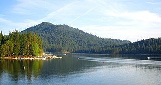
Bass Lake, situated in Madera County, California, within the Sierra National Forest and approximately 14 mi (23 km) south of Yosemite National Park, is a popular recreational area. The lake, formed by the Crane Valley Dam on Willow Creek, a tributary to the San Joaquin River, spans about four miles (6.4 km) in length and one-half mile (0.80 km) in width. Constructed in 1910 by Pacific Gas and Electric, the 145 ft (44 m) concrete gravity dam generates hydro-electric power through controlled releases. The lake supports a diverse ecosystem, including species such as black bears, mule deer, bald eagles, and Great blue herons, along with a variety of fish species.

<span class="mw-page-title-main">Fish Camp, California</span> Census-designated place in California, United States

Fish Camp is a census-designated place in Mariposa County, California, United States. It is located 18 miles (29 km) east of Mariposa, at an elevation of 5,062 feet (1,543 m). The population was 49 at the 2020 census. The ZIP Code is 93623, and the community is inside area code 559.

Whisky Falls is an unincorporated area of Madera County, California. It is located 4.5 miles (7.2 km) south of Shuteye Peak, at an elevation of 5,912 feet.

Wishon is a former settlement in Madera County, California. It has been inundated by Bass Lake.

The North Fork Rancheria of Mono Indians of California is a federally recognized tribe of Mono Native Americans. North Fork Rancheria is the name of the tribe's reservation, which is located in Madera County, California. Nium is their self-designation.

<span class="mw-page-title-main">Hume-Bennett Lumber Company</span> Logging operation in the Sequoia National Forest

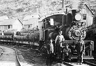
The Hume-Bennett Lumber Company was a logging operation in the Sequoia National Forest in the late 19th and early 20th centuries. The company and its predecessors were known for building the world's longest log flume and the first multiple-arch hydroelectric dam. However, the company also engaged in destructive clearcutting logging practices, cutting down 8,000 giant sequoias in Converse Basin in a decade-long event that has been described as "the greatest orgy of destructive lumbering in the history of the world."

Lyonsville in Tehama County, California was the site of the Lyonsville Mill, a major lumber operation which was once the largest sawmill in Northern California. It was located between the north and south forks of Antelope Creek, high above Hogsback Ridge. The mill served logging operations around Antelope Creek, and around it grew a town of the same name, with two saloons, a community hall, a general store, a post office, and machine and blacksmith shops. At its peak, there were more than 1000 people in the town.

<span class="mw-page-title-main">Madera Sugar Pine Company</span> Defunct logging company in Madera County, California, US

The Madera Sugar Pine Company was a lumber company that operated in the Sierra Nevada region of California during the late 19th and early 20th centuries. The company distinguished itself through the use of innovative technologies, including the southern Sierra's first log flume and logging railroad, along with the early adoption of the Steam Donkey engine. Its significant regional impact led to the establishment of towns such as Madera, Fish Camp, and Sugar Pine, as well as the growth of Fresno Flats and the formation of Madera County.

<span class="mw-page-title-main">Sugar Pine Lumber Company</span> Defunct logging company in Madera and Fresno County, California, US

The Sugar Pine Lumber Company was an early 20th century logging operation and railroad in the Sierra Nevada. Unable to secure water rights to build a log flume, the company operated the “crookedest railroad ever built." They later developed the Minarets-type locomotive, the largest and most powerful saddle tank locomotive ever made. The company was also a pioneer in the electrification of logging where newly plentiful hydroelectric power replaced the widespread use of steam engines.

<span class="mw-page-title-main">Yosemite Lumber Company</span> Defunct logging company in Yosemite National Park, California, US

The Yosemite Lumber Company was an early 20th century Sugar Pine and White Pine logging operation in the Sierra Nevada. The company built the steepest logging incline ever, a 3,100 feet (940 m) route that tied the high-country timber tracts in Yosemite National Park to the low-lying Yosemite Valley Railroad running alongside the Merced River. From there, the logs went by rail to the company’s sawmill at Merced Falls, about fifty-four miles west of El Portal.

<span class="mw-page-title-main">Millwood, California</span> Former logging boomtown in Fresno County, California, US

Millwood was a lumber boomtown located in present-day Sequoia National Forest near Converse Basin Grove in California. It was established in 1891 by the Kings River Lumber Company and was connected to the Sequoia Railroad, which brought logs to the town to be turned into rough lumber. The lumber was then transported by log flume to Sanger, a journey of 54 miles. At its peak, Millwood had a population of over 2,000 people and featured two hotels, a summer school, and a post office. However, today there are no remaining structures or buildings at the Millwood site.

The following is a timeline of the history of the Sierra National Forest in Central California, United States.

References

  1. 1 2 "2021 U.S. Gazetteer Files: California". United States Census Bureau. Retrieved June 28, 2022.
  2. 1 2 3 4 U.S. Geological Survey Geographic Names Information System: North Fork
  3. 1 2 "P1. Race – North Fork CDP, California: 2020 DEC Redistricting Data (PL 94-171)". U.S. Census Bureau. Retrieved June 28, 2022.
  4. U.S. Geological Survey Geographic Names Information System: North Fork Census Designated Place
  5. Sydney M. Lamb. 1957. Mono Grammar. University of California. Berkeley PhD dissertation. .pdf
  6. 1 2 "Western Regional Climate Center: 1981-2010 monthly climate summary for North Fork" . Retrieved October 24, 2014.
  7. "Plantmaps: Zip Code 93643 North Fork Hardiness Zone and Gardening Info" . Retrieved October 24, 2014.
  8. "NOWData - NOAA Online Weather Data". NOAA. Retrieved August 9, 2023.
  9. 1 2 3 4 5 6 United States Census Bureau. "North Fork CDP, California." Retrieved from
  10. 1 2 Lee, Gaylen D. (1998). Walking Where We Lived: Memoirs of a Mono Indian Family. University of Oklahoma Press. ISBN   0-8061-3087-3.
  11. "Horse Stage from Madera Only Means of Access To North Fork District in Early Day Activity". Madera Tribune. September 28, 1948. Retrieved June 25, 2023.
  12. "The History Of The Towns And Cities". Vol. 77. Madera Tribune. May 21, 1968.
  13. 1 2 3 Rose, Gene (1994). Sierra Centennial: 100 Years of Pioneering on the Sierra National Forest. Three Forests Interpretive Association. ISBN   0-944194-31-1.
  14. "Peckinpah Mountain Reunion Scene". Madera Tribune. Vol. 70, no. 41. July 12, 1961.
  15. "How a Gold Rush Era Lumber Town Struck Gold a Second Time". Sierra News Online. April 24, 2023.
  16. "Lumber Company Built a Railroad Instead of a Flume". Madera Tribune. Madera, California. June 11, 1968. Retrieved September 29, 2022.
  17. "First Log Sawed in 1943 North Fork Logging Boomed in 40s and 50s". Madera Tribune. September 25, 1951. Retrieved June 25, 2023.
  18. "County Is Named For Industry". Madera Tribune. September 21, 1954. Retrieved June 25, 2023.
  19. "North Fork to Expand with New Program". Madera Tribune. Vol. LV, no. 81. June 5, 1947. Retrieved June 25, 2023 via California Digital Newspaper Collection.
  20. "Lumber Experience Possessed By Men Of Associated Box". Madera Tribune. September 22, 1953. Retrieved June 25, 2023.
  21. 1 2 3 "North Fork's Prominence As A Mill Town Began In The 1940s". Sierra News Online. June 22, 2012. Retrieved June 25, 2023.
  22. "Mill Site History". North Fork Community Development Council. Retrieved June 25, 2023.
  23. "North Fork, California". sierranevadageotourism.org. Retrieved May 19, 2020.
  24. "South Ops National Interagency Hotshot Crew". US Forest Service. December 22, 2016. Retrieved June 27, 2023.
  25. "The Sierra Mono Museum" . Retrieved June 25, 2023.
  26. "Sierra Vista Scenic Byway" . Retrieved June 25, 2023.
  27. "County's Resorts Seem To Have Nearly Everything". Madera Tribune. Vol. 65, no. 107. September 18, 1956. Retrieved June 25, 2023.
  28. "Find Smith Guilty Of Assault". Madera Tribune. No. 96. May 23, 1952. Retrieved June 25, 2023.
  29. "Smith Sentenced To 6 Months Jail". Madera Tribune. No. 110. June 10, 1952. Retrieved June 25, 2023.
  30. Clugston, Gina (April 6, 2016). "Clampers Add North Fork To Historic Monument Sites". Sierra News Online. Retrieved June 26, 2023.
  31. "Exact Center of California: North Fork". Sierra Nevada Geotourism. Retrieved June 26, 2023.
  32. "Big Day In North Fork July 6". Madera Tribune. Vol. 72, no. 32. June 27, 1963. Retrieved June 26, 2023.
  33. "Large Crowd Attends Loggers Jamboree". Madera Tribune. Vol. 77, no. 43. July 12, 1968. Retrieved June 26, 2023.
  34. Flanagan, Kellie (July 6, 2019). "Ladies And Gentlemen Grab Your Axes: 60th Annual Mid-Sierra Loggers Jamboree". Sierra News Online. Retrieved June 26, 2023.

Notes

  1. Mean monthly maxima and minima (i.e. the expected highest and lowest temperature readings at any point during the year or given month) calculated based on data at said location from 1945 to 2023.