
Bee Hive is a 6,904 feet (2,104 m) Navajo Sandstone mountain in Zion National Park in Washington County, Utah, United States, that is part of the Towers of the Virgin.

The Watchman is a 6,545-foot (1,995 m) sandstone mountain summit located in Zion National Park, in Washington County of southwest Utah, United States.
Johnson Mountain is a 6,106-foot (1,861 m) Navajo Sandstone summit located in Zion National Park, in Washington County of southwest Utah, United States.

Nagunt Mesa is a 7,785-foot (2,373 m) mountain summit located in the Kolob Canyons area of Zion National Park in Washington County, Utah, United States.

The Sentinel is a 7,120+ ft elevation Navajo Sandstone summit located near the Court of the Patriarchs in Zion National Park, in Washington County of southwest Utah, United States, that is part of the Towers of the Virgin. The national park map lists the elevation as 7,157-feet.

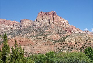
Cathedral Mountain is a 6,930-foot (2,110 m) elevation Navajo Sandstone summit located in Zion National Park, in Washington County of southwest Utah, United States.

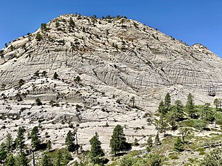
Observation Point is a 6,507-foot (1,983 m) elevation Navajo Sandstone feature located in Zion National Park, in Washington County of southwest Utah, United States. Observation Point is situated at the north end of Zion Canyon, towering 2,100 feet above the canyon floor and the North Fork of the Virgin River which drains precipitation runoff from this viewpoint. A popular 8-mile round-trip trail climbs from the Weeping Rock trailhead along Zion Canyon Road to reach the top. Neighbors visible from the point include The Great White Throne, Cathedral Mountain, Angels Landing, and Cable Mountain. This geographical feature's name was officially adopted in 1934 by the U.S. Board on Geographic Names.

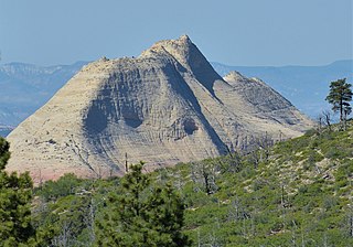
Mount Majestic, also known as Majestic Mountain, is a 6,956-foot (2,120 m) elevation Navajo Sandstone double-summit mountain located in Zion National Park, in Washington County of southwest Utah, United States.

Ivins Mountain is a remote 7,019-foot (2,139 m) Navajo Sandstone summit located in Zion National Park, in Washington County of southwest Utah, United States.

Inclined Temple is a remote 7,150-foot elevation summit located in Zion National Park, in Washington County of southwest Utah, United States.
South Guardian Angel is a 7,140-foot (2,180 m) summit located in Zion National Park, in Washington County of southwest Utah, United States.

Three Marys are three sandstone pillars in Zion National Park in Washington County, Utah, United States.

Mountain of Mystery is a 6,565-foot (2,001 m) Navajo Sandstone summit located in Zion National Park, in Washington County of southwest Utah, United States. Mountain of Mystery is situated above The Narrows, towering over 2,100 feet above the floor of Zion Canyon and the North Fork Virgin River which drains precipitation runoff from this mountain. This peak rises above Orderville Canyon on its north side, and Mystery Canyon on the south. Its neighbors include Mount Majestic, Cathedral Mountain, Observation Point, Cable Mountain, Angels Landing, and The Organ. This feature's name was officially adopted in 1934 by the U.S. Board on Geographic Names. The first ascent via the Northeast Buttress was made 15 September 2001, by Brian Cabe and Tom Jones.

Pine Valley Peak is a 7,415-foot (2,260 m) mountain located in Zion National Park in Washington County, Utah, United States.

Deertrap Mountain is a 6,837-foot (2,084 m) mountain in Zion National Park in Washington County, Utah, United States.

Cave Knoll is a 6,486-foot (1,977 m) summit located in Zion National Park, in Washington County of southwest Utah, United States. Cave Knoll, a formation composed of Navajo Sandstone, is situated in Cave Valley, 11.5 mi (18.5 km) northwest of Springdale, Utah. Its neighbors include Pine Valley Peak, 1.7 mi (3 km) to the northeast, Tabernacle Dome, 1.6 mi (3 km) to the south-southeast, and North Guardian Angel, 2.5 mi (4 km) to the east. Precipitation runoff from this mountain drains into tributaries of the Virgin River. Access to this peak is via the Kolob Terrace Road. This peak's name was officially adopted in 1934 by the U.S. Board on Geographic Names.

Tabernacle Dome is a 6,430-foot elevation summit located in Zion National Park, in Washington County of southwest Utah, United States. Tabernacle Dome, a formation composed of Navajo Sandstone, is situated at the southeastern end of Cave Valley, 10 mi (16 km) northwest of Springdale, Utah. Its nearest higher neighbor is Cave Knoll, 1.6 mi (3 km) to the north-northwest. Other neighbors include South Guardian Angel, 1.9 mi (3 km) to the east, and North Guardian Angel, 2.2 mi (4 km) to the northeast. Precipitation runoff from this mountain drains into tributaries of the Virgin River. Access to this peak is via the Kolob Terrace Road. This peak's name was officially adopted in 1934 by the U.S. Board on Geographic Names. It is named for its resemblance to the Mormon Tabernacle in Salt Lake City.

Paria Point is a 7,802-foot (2,378 m) elevation summit located in the Kolob Canyons section of Zion National Park, in Washington County, Utah, United States. Tucupit Point is situated 0.5 mi (0.80 km) immediately north, and Beatty Point is 0.5 mi (0.80 km) immediately south, with 2,000-foot-deep finger canyons between each. Other neighbors include Nagunt Mesa and Timber Top Mountain to the south, and Horse Ranch Mountain to the north. Paria Point is composed of Jurassic Navajo sandstone overlaying tilted Kayenta Formation. Precipitation runoff drains into Taylor Creek, which is part of the Virgin River drainage basin. This feature's paria name is a Paiute word meaning "muddy water" or "elk water".

Beatty Point is a 7,780-foot (2,370 m) elevation summit located in the Kolob Canyons area of Zion National Park in Washington County, Utah, United States.
Northgate Peaks are two summits in Washington County, Utah, United States.


