Northern Range

Last updated
A shaded relief map of Trinidad showing the Northern Range Trinidad and Tobago Shaded Relief PCL Texas Annotated.jpg
A shaded relief map of Trinidad showing the Northern Range
The hills of the Northern Range rising behind the Queen's Park Oval in Trinidad. Northern Range rising behind Queen's Park Oval Trinidad.jpg
The hills of the Northern Range rising behind the Queen's Park Oval in Trinidad.

The Northern Range is the range of tall hills across north Trinidad, the major island in the Republic of Trinidad and Tobago. The hills range from the Chaguaramas peninsula on the west coast to Toco in the east. [1] The Northern Range covers approximately twenty-five percent of the land area of Trinidad.

Contents

The hills rise abruptly from the lowlands of northern Trinidad (the so-called East–West Corridor), but only the two tallest peaks, El Cerro del Aripo and El Tucuche top 900 m. On the summits of El Cerro del Aripo and El Tucuche, the vegetation is quite different from the lower montane forests. Elfin woodland and cloud forests cover the summits, and are home to the near endemic El Tucuche golden tree frog. The south-facing valleys run deep into the hills and support major rivers, such as the Caroni River, while the north-facing valleys are generally short and are drained by smaller streams.

The biodiversity within the Northern Range, which represents a combination of species from the South American continent and from the Caribbean islands further north is high. The densely forested peaks are home to over 100 species of mammals and 430 species of birds. Animals such as red howler monkeys, capuchin monkeys, neotropical river otters, collared peccary, ocelots and red brocket deer, to name a few, inhabit the lush forests, making the Northern Range the only mountain range in the Caribbean to host such species.

There are numerous streams and waterfalls in the Northern Range. The highest waterfall is Maracas waterfall, towering 91.5 metres (300 ft) high. Other waterfalls include the Rincon Falls, Rio Seco Falls and Marianne Falls. Numerous sulphur springs occur on the river beds of Rio Seco Falls, demonstrating the volcanic nature of the region.

The Northern Range consists mainly of sedimentary rocks, schists and limestones; portions at the eastern end of the range are of volcanic origin. The hills are mostly forested, although deforestation and the formation of fire-savannahs is one of the major environmental concerns in Trinidad.

The country's largest cave system, the Aripo Cave, is located in the Northern Range. The caves feature stunning stalagmite and stalactite formations. These caves are inhabited by nocturnal oilbirds, and bats.

The Northern Range runs from the Chaguaramas Peninsula in the west to Toco in the east. The eastern Northern Range (areas east of Arima) remain most heavily forested. Portions west of Arima, especially the southern slopes and valleys, have been extensively deforested, since they lie immediately north of the most heavily populated parts of the island.

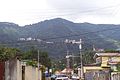
At the western end of the Northern Range, the capital city, Port of Spain, climbs into the hills and the valleys are settled and largely deforested.

The Arima Valley remains as the westernmost valley that is still primarily forested, in a large part due to the presence of the Asa Wright Nature Centre in this valley.

See also

Related Research Articles

Geography of Trinidad and Tobago

Trinidad and Tobago is an archipelagic republic in the southern Caribbean between the Caribbean Sea and the North Atlantic Ocean, northeast of Venezuela. They are southeasterly islands of the Lesser Antilles, Monos, Huevos, Gaspar Grande, Little Tobago, and St. Giles Island. Trinidad is 11 km (6.8 mi) off the northeast coast of Venezuela and 130 km (81 mi) south of the Grenadines. The island measures 4,768 km2 (1,841 sq mi) in area with an average length of 80 km (50 mi) and an average width of 59 km (37 mi). The island appears rectangular in shape with three projecting peninsular corners. Tobago is 30 km (19 mi) northeast of Trinidad and measures about 298 km2 (115 sq mi) in area, or 5.8% of the country's area, 41 km (25.5 mi) in length and 12 km (7.5 mi) at its greatest width. The island is cigar-shaped in appearance, with a northeast-southwest alignment.

Port of Spain Capital of Trinidad and Tobago

Port of Spain, officially the City of Port of Spain, is the capital city of Trinidad and Tobago, the country's second-largest city after San Fernando, and the third largest municipality after Chaguanas and San Fernando. The city has a municipal population of 37,074, an urban population of 81,142 and a transient daily population of 250,000. It is located on the Gulf of Paria, on the northwest coast of the island of Trinidad and is part of a larger conurbation stretching from Chaguaramas in the west to Arima in the east with an estimated population of 600,000.

Trinidad The larger of the two major islands which make up the nation of Trinidad and Tobago

Trinidad is the larger and more populous of the two major islands of Trinidad and Tobago. The island lies 11 km (6.8 mi) off the northeastern coast of Venezuela and sits on the continental shelf of South America. It is often referred to as the southernmost island in the West Indies. With an area of 5,131 km2 (1,981 sq mi), it is also the fifth largest in the West Indies.

Asa Wright Nature Centre

The Asa Wright Nature Centre and Lodge is a nature resort and scientific research station in the Arima Valley of the Northern Range in Trinidad and Tobago. The centre is one of the top birdwatching spots in the Caribbean; a total of 256 species of birds have been recorded there. The centre is owned by a non-profit trust.

El Cerro del Aripo

El Cerro del Aripo, at 940 metres (3,084 ft), is the highest point in the Republic of Trinidad and Tobago. It is part of the Aripo Massif and is located in the Northern Range on the island of Trinidad, northeast of the town of Arima.

Caroni County

Caroni County is a historic county of Trinidad and Tobago. It occupies 557 km2 (215 sq mi) in the west central part of the island of Trinidad, the larger island in the Republic of Trinidad and Tobago. It lies south and southwest of Saint George County, west of Nariva County and north of Victoria County. To the west it is bounded by the Gulf of Paria. County Caroni includes the towns of Chaguanas, the largest town in the country and Couva, the capital of the Couva–Tabaquite–Talparo region. Administratively it is divided between the Borough of Chaguanas, the Couva–Tabaquite–Talparo Regional Corporation and the Tunapuna–Piarco Regional Corporation. The county was divided into four Wards: Chaguanas, Couva, Cunupia and Montserrat. The major towns of County Caroni are Chaguanas and Couva. The port and industrial zone of Point Lisas is located in Caroni, and the region is also a site for agriculture.

Cocoa panyols

The Panyols are a Pardo (tri-racial) ethnic group in Trinidad and Tobago of mixed Spanish, South American Amerindian, Trinidadian and Tobagonian Amerindian, Afro-Latin American, and Afro-Trinidadian and Tobagonian descent. They comprise the Cocoa Estate Plantations owners community along with peasant workers from Venezuela and Colombia, also referred to as Pagnols, local Spanish, Cocoa panyols. They were born of the shared Island nation, on both sides of the Gulf of Paria, Peninsulas that settling within the Northern Range Rain Forest Mountains Valleys of Trinidad and Tobago Caura River, down the mountains into the Tacarigua River into the Caroni River, and the Orinoco, and Caura River, Venezuela. They played an important role in the development of the cocoa industry in Trinidad and Tobago, running the Cocoa Estate and not to be confused with the freed community of former slaves.

Caroni River (Trinidad and Tobago)

The Caroni River is the largest river in Trinidad and Tobago, running for 40 km (25 mi) from its origins in the Northern Range on the island of Trinidad, through the northern lowlands of the Caroni Plains and enters the Gulf of Paria at the Caroni Swamp.

Saint George County

Saint George is a county in Trinidad and Tobago. It occupies the northwestern portion of the island of Trinidad and is bounded by the Caribbean Sea to the north, the Gulf of Paria to the west, Caroni County to the south and Saint David County and Saint Andrew County to the east. It occupies an area of 912 km2 (352 sq mi). The county includes the Bocas Islands and the towns of Port of Spain and Arima. It also includes the small town of Blanchisseuse and its attractive beach, backed by a forest-fringed lagoon. County Saint George is divided into six Wards: Diego Martin, Saint Ann's, Blanchisseuse, Tacarigua, Arima and San Raphael.

Maracas–Saint Joseph is a colloquial name used in Trinidad and Tobago to distinguish the Maracas Valley above the town of Saint Joseph from Maracas Beach. Maracas–Saint Joseph is one of the large valleys on the southern side of the Northern Range, while Maracas Beach lies on the opposite side of the mountains.

El Tucuche

El Tucuche is the second highest peak in Trinidad's Northern Range and is noted for its interesting pyramidal shape. It is fabled in Amerindian lore as a sacred mountain. There are Amerindian petroglyphs on a rock outcrop below the mountain. These are the only petroglyphs found in the country.

Central Range (Trinidad and Tobago)

The Central Range is a mountain range on the island of Trinidad. It extends diagonally across the island and is a low-lying range with swampy areas rising to rolling hills. The tallest hills are Mount Tamana, Mount Harris and Brigand Hill, all located in the northeastern portion of the range. The Central Range mountains are biodiverse, and are home to the Tamana Caves. Trinidad's, as well as one of the world's largest bat colony is located here. Howler monkeys can be found here and numerous species of birds as well.

Tunapuna–Piarco Region

Tunapuna–Piarco is one of the 9 regions of Trinidad and Tobago. It is the most populous region in the country by total population and the fifth-largest by total land area. Geographically located in Northern Trinidad, Tunapuna–Piarco shares its borders with the regions of San Juan–Laventille to the west, Couva–Tabaquite–Talparo to the south, the Borough of Chaguanas to the south-west, Sangre Grande to the east and the Caribbean Sea to the north. The region also completely surrounds the Royal Chartered Borough of Arima, which is located in the south-eastern corner of the region.

Maracas Valley

Maracas Valley is a valley in Trinidad that is separated by two mountains between Maracas–Saint Joseph and Maracas Beach.

Phytotriades is a genus of tree frogs in the family Hylidae. As currently delimited, the genus is monotypic and contains Phytotriades auratus, commonly known as the golden tree frog, bromeliad-dwelling treefrog, El Tucuche golden tree frog, or Trinidad heart-tongued frog.

Index of Trinidad and Tobago–related articles wikimedia list article

The following is an alphabetical list of topics related to the Republic of Trinidad and Tobago.

Heights of Aripo Village

Heights of Aripo Village is located in the Northern Range of the island of Trinidad. It is presumed this village, which lies in known Amerindian territory of the Nepuyo people, was at one point inhabited by first peoples. The work provided by later Cocoa Estates would have been a major draw for labour and settlers in the twentieth century. Few of the Estate houses remain many Cocoa Houses are still visible in the community either repurposed and inhabited or dilapidated. Most of the villagers have moved away from cocoa production, agricultural production still remains a big part of the community. The area is now the second largest producer of watercress on the island and the village has been working with The Caribbean Natural Resources Institute (CANARI) to further business opportunities for the village and help its sustainability.

References

  1. Northern Range Assessment (2005). Report of an Assessment of the Northern Range, Trinidad and Tobago: People and the Northern Range (page 3). State of the Environment Report 2004. Environmental Management Authority of Trinidad and Tobago.

Coordinates: 10°44′N61°15′W / 10.733°N 61.250°W / 10.733; -61.250