The Northwestern Turnpike is a historic road in West Virginia (Virginia at the time the road was created), important for being historically one of the major roads crossing the Appalachians, financed by the Virginia Board of Public Works in the 1830s. In modern times, west of Winchester, Virginia, U.S. Route 50 follows the path of the Northwestern Turnpike into West Virginia, whose major Corridor D project follows the western section of the original Northwestern Turnpike.
"Stagecoach stop on the Northwestern Turnpike" (1846), by Joseph H. Diss Debar. ("The first coach ... that ever traveled from Winchester to the Ohio River.")
The following description of the Northwestern Turnpike is taken from Dr. J. M. Callahan's Semi-Centennial History of West Virginia, pages 106-9, published in 1913:
"The old Northwestern Turnpike, extending from Winchester, Virginia on a general westward course to Parkersburg, West Virginia on the Ohio, is a historic highway which deserves more mention than it has ever received as a factor related to the American westward movement and to the problem of communication between East and West. It was the inevitable result of the call of the West and the need of a Virginia state road."
"Perhaps its first suggestion was recorded by George Washington, who in 1758 had been the champion of the Braddock road (not then supposed to lie in Pennsylvania) and who in 1784 sought a route located wholly in Virginia. Returning from a visit to his western lands, after following McCulloch's Path (then the most important route across the rugged ridges between the valleys), he crossed the North Branch Potomac River on the future route of the greater Virginia highway which was partially realized in the 'state road' authorized from Winchester via Romney to Morgantown before 1786, and extended westward in 1786 by a branch road from near Cheat to Clarksburg, from which the first road was marked to the mouth of the Little Kanawha River between 1788 and 1790."
"The later turnpike was planned and constructed by Virginia partly as a result of the rival activities of New York, Pennsylvania, and Maryland to secure the advantage in transportation facilities for the trade of the West; and was especially regarded as a rival of the National Road which was opened from Cumberland to Wheeling in 1818, and with which parts of Virginia obtained better connection in 1830 by a stage line established from Winchester to Cumberland. It was built across the Appalachian Divide with the hope of securing commercial superiority, and was the main thoroughfare between East and West through northern Virginia."
"The act in incorporation of 1827, authorizing subscriptions at Winchester, Romney, Moorefield, Beverly, Kingwood, Pruntytown, Clarksburg, and Parkersburg made the mistake of arbitrarily locating the route through important towns without proper consideration of the physical features of the country. After finding a way through Hampshire County via Mechanicsburg Gap in Mill Creek Mountain, and pushing on into Preston County, the engineers encountered insurmountable obstacles to the Kingwood route, causing the stock to languish."
"The enterprise was saved by the remarkable act of 1831 which organized a road company, with the Governor as President and one of the Board of Directors, with power to borrow money ($125,000) on the credit of the State to construct a turnpike road of a minimum width of twelve feet, 'from Winchester to some point on the Ohio River to be situated by the principal engineer', and with the right to erect bridges or to regulate ferries already in existence and to establish toll-gates on each twenty-mile (32km) section completed."
"No longer dependent on the larger towns for its success, the road was completed through the wilds of Preston, considerably south of Kingwood, in 1832, and was opened westward to Clarksburg and Parkersburg by 1838. Its construction cost $400,000. It crossed the mountains by easy grades and the larger streams (in some sections all the streams) by good bridges. It was macadamized from Tygart Valley River to Parkersburg in 1848. About 1852, it was further improved by construction of new bridges across several streams at important crossings. In 1840, facilities for travel and news were increased on the western end of the road by the establishment of a daily line of stages, and a regular mail service, which made connection with the Ohio steamers at Parkersburg. By 1845, there was a line of fast tri-weekly stages at Romney to the Ohio at Parkersburg. It connected at Romney with stages from Winchester, from Moorefield, and from Green Spring at which connections were made with Baltimore by trains of the Baltimore and Ohio Railway. The fare from Green Spring to Parkersburg (210 miles) was $10.00."
"The road, establishing commercial and other relations, soon became a busy thoroughfare of travel and traffic which stimulated the creation of many inns and towns along the route - such as Aurora, Fellowsville, Evansville (1833), and West Union (1846). In many ways it influenced the material prosperity and social life of the people of the region through which it passed. Following the act of 1831, which provided for satisfactory adjustment of land titles, it was an important incentive to immigration and settlement and development - especially along the region of southern Preston and in Ritchie. Its construction also stimulated the construction of intersecting roads, such as the Brandonville pike, starting from Somerfield, Pennsylvania, passing via Kingwood, and connecting with the Northwestern at a point which became Fellowsville by 1848. It also doubtless influenced the legislature in 1837 to provide for a survey of Cheat from the turnpike crossing to the Pennsylvania line. On some parts of the course it furnished the incentive for the establishment of inns to meet the needs of those who desired to escape the heat of the seaboard by a summer sojourn amid the wild beauty of the mountains, whose streams were filled with trout and whose forest furnished a home for deer and other game."
"Beyond the headwaters of the Potomac, it passed over the Backbone, opening the way to a remote and inaccessible region bordering on the land of Canaan, which was made famous a few years later by 'The Clerk of Oxenford' (David Hunter Strother) in 'The Blackwater Chronicle' and later by the same writer under the nom de plume 'Porte Crayon' in 'A Visit to the Virginian Canaan.'"
"It might have been a road of greater importance if Virginia soon after its completion had not been induced to divert her interest from turnpikes to canals - influenced by the completion of a Pennsylvania system of transportation connecting with the Ohio at Pittsburgh. West of the Alleghenies, it was extensively damaged by the numerous heavy cattle driven over it in the winter and early spring. It was also much injured by high waters, especially in 1852 and 1853."
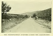
Northwestern Turnpike, circa 1908
"Although it never became of national importance as did its more renowned national rival at the north, it was for a while the busy scene of much business of a national character and gave fair promise of serving well the purpose for which Virginia had planned it until its larger usefulness was transferred to its horseless rival which, persistently overcoming obstacles and opposition, reached Cumberland by 1845, Grafton in 1852, and Parkersburg in 1857."
"Supported by a sentiment that long scorned the possibility of competition and that later opposed any improved system of transportation which, by absorbing the slower traffic, might close the taverns and ruin the local market for grain and provisions, it was finally paralleled by a railroad which diverted its travel and traffic, created rival towns, and brought pioneer prospectors and promoters who prepared the way for the later era of larger industrial development."
"Although its utility was diminished by proximity to the railroad, it was still in moderate repair in the decade after the close of the war, and it has continued a constant local benefit to the territory through which it passes."
"While the Northwestern Turnpike does not cross Hardy County, it has affected the transportation to a large extent from the Moorefield and Petersburg regions to the north, and with the completion of West Virginia Route 28 to Junction will be the main outlet, both eastward and westward, for all the region from Moorefield southward, or until such time as old West Virginia Route 54 (now WV 28) is paved from Romney to Alaska from which point a hard-surfaced road extends to Cumberland where connection is made with the National Road (U.S. Route 40)."
Capon Bridge East of Capon Bridge at Smokey Hollow Road (CR 6)
Related Research Articles
Hampshire County is a county in the U.S. state of West Virginia. As of the 2020 census, the population was 23,093. Its county seat is Romney, West Virginia's oldest town (1762). The county was created by the Virginia General Assembly in 1754, from parts of Frederick and Augusta Counties (Virginia) and is the state's oldest county. The county lies in both West Virginia's Eastern Panhandle and Potomac Highlands regions.
U.S. Route 50 or U.S. Highway 50 (US 50) is a major east–west route of the U.S. Highway system, stretching 3,019 miles (4,859 km) from Interstate 80 (I-80) in West Sacramento, California, to Maryland Route 528 in Ocean City, Maryland, on the Atlantic Ocean. Until 1972, when it was replaced by Interstate Highways west of the Sacramento area, it extended to San Francisco, near the Pacific Ocean. The Interstates were constructed later and are mostly separate from this route. It generally serves a corridor south of I-70 and I-80 and north of I-64 and I-40.
Joseph Ellis Johnson was a farmer, businessman, and politician who served as United States Representative and became the 32nd Governor of Virginia from 1852 to 1856, the first Virginia governor to be popularly elected as well as the only Virginia governor from west of the Appalachian mountains. During the American Civil War, he sympathized with the Confederacy, but returned to what had become West Virginia for his final years.
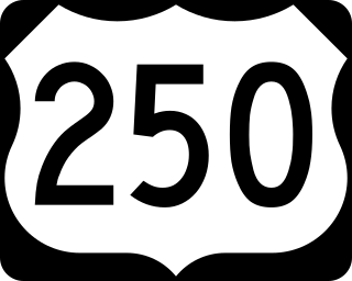
U.S. Route 250 is a route of the United States Numbered Highway System, and is a spur of U.S. Route 50. It currently runs for 514 miles (827 km) from Richmond, Virginia to Sandusky, Ohio. It passes through the states of Virginia, West Virginia, and Ohio. It goes through the cities of Richmond, Charlottesville, Staunton, and Waynesboro, Virginia; and Wheeling, West Virginia. West of Pruntytown, West Virginia, US 250 intersects and forms a short overlap with its parent US 50.
The South Branch Potomac River has its headwaters in northwestern Highland County, Virginia near Hightown along the eastern edge of the Allegheny Front. After a river distance of 139 miles (224 km), the mouth of the South Branch lies east of Green Spring in Hampshire County, West Virginia where it meets the North Branch Potomac River to form the Potomac.
The Sloan–Parker House, also known as the Stone House, Parker Family Residence, or Richard Sloan House, is a late-18th-century stone residence near Junction, Hampshire County, in the U.S. state of West Virginia. It was built on land vacated by the Shawnee after the Native American nation had been violently forced to move west to Kansas following their defeat at the Battle of Point Pleasant in 1774. The building was added to the National Register of Historic Places on June 5, 1975, becoming Hampshire County's first property to be listed on the register. The Sloan–Parker House has been in the Parker family since 1854. The house and its adjacent farm are located along the Northwestern Turnpike in the rural Mill Creek valley.
West Virginia Route 28 is a north–south route through the Potomac Highlands of the U.S. state of West Virginia. The southern terminus of the route is at West Virginia Route 39 in Huntersville. The northern terminus is at the Maryland state line in Wiley Ford, where the route continues into Cumberland as Canal Parkway upon crossing the North Branch Potomac River.
The South Branch Valley Railroad is a 52.4-mile-long (84.3 km) railroad in the Eastern Panhandle of West Virginia. The branch line, which parallels the South Branch Potomac River, runs north from Petersburg to Green Spring, where it connects to the national rail network at a junction with the CSX Cumberland Subdivision.
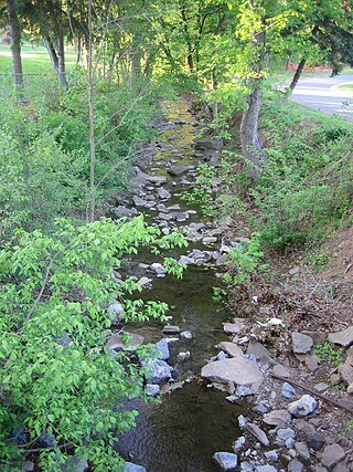
Mill Creek is a 14.0-mile-long (22.5 km) tributary stream of the South Branch Potomac River, belonging to the Potomac River and Chesapeake Bay watersheds. The stream is located in Hampshire County in West Virginia's Eastern Panhandle. Mill Creek flows into the South Branch west of Romney Bridge near Vanderlip along the Northwestern Turnpike.
Big Run is a 4.4-mile-long (7.1 km) tributary stream of the South Branch Potomac River, belonging to the Potomac River and Chesapeake Bay watersheds. Big Run flows through the city of Romney and the campus of the West Virginia Schools for the Deaf and Blind in Hampshire County, West Virginia. The stream is known by local residents as Town Run and Town Creek.
U.S. Route 50 in West Virginia runs from the border with Ohio to Virginia, passing briefly through Garrett County, Maryland, and following the Northwestern Turnpike. Prior to the U.S. Highway System it was West Virginia Route 1 and in the 1930s, the road was not finished in Maryland. Today the section of US 50 from Clarksburg to Parkersburg on the Ohio River is part of Corridor D of the Appalachian Development Highway System.
The Great Indian Warpath (GIW)—also known as the Great Indian War and Trading Path, or the Seneca Trail—was that part of the network of trails in eastern North America developed and used by Native Americans which ran through the Great Appalachian Valley. The system of footpaths extended from what is now upper New York to deep within Alabama. Various Native peoples traded and made war along the trails, including the Catawba, numerous Algonquian tribes, the Cherokee, and the Iroquois Confederacy. The British traders' name for the route was derived from combining its name among the northeastern Algonquian tribes, Mishimayagat or "Great Trail", with that of the Shawnee and Delaware, Athawominee or "Path where they go armed".
U.S. Route 220 (US 220) is a U.S. Highway that travels from Rockingham, North Carolina, to South Waverly, Pennsylvania. In the state of West Virginia, it travels for 93 miles (150 km) from the Virginia state line two miles (3.2 km) south of Harper to the Maryland state line at Keyser.
Moorefield and North Branch Turnpike was a turnpike in the U.S. state of Virginia built to facilitate travel and commerce between the Baltimore and Ohio Railroad at Green Spring on the North Branch Potomac River and Moorefield. Today, Green Spring Road, Harriott-Wappocomo Road, and West Virginia Route 28 encompass most of the Moorefield and North Branch Turnpike's original route.
The 123rd Ohio Infantry Regiment, sometimes 123rd Ohio Volunteer Infantry was an infantry regiment in the Union Army during the American Civil War.
The Capon and North Branch Turnpike was a 19th-century turnpike in Hampshire County in the U.S. state of Virginia. The turnpike facilitated increased communication and transportation between Cumberland, Maryland and Winchester, Virginia via the Northwestern Turnpike in Capon Bridge, West Virginia. As of July 2010, the Capon and North Branch Turnpike's original route is made up of segments of West Virginia Route 28, Springfield Pike, Slanesville Pike, and Cold Stream Road.
William Benjamin Cornwell was an American lawyer, businessperson, newspaper editor and publisher, and railroad and timber executive in the U.S. state of West Virginia. He was an older brother of writer and newspaper publisher Marshall S. Cornwell (1871–1898) and of West Virginia Governor John J. Cornwell (1867–1953).
James Caudy was an American frontiersman, settler, and landowner in the Ridge-and-Valley Appalachians of the Colony of Virginia—present-day West Virginia. Caudy was born in the Netherlands, immigrated to the Thirteen Colonies in the 1730s, and settled within the Cacapon River valley near present-day Capon Bridge in Hampshire County. As early as 1741, Caudy was associated with the arrangement and development of transportation routes throughout present-day Hampshire County. Caudy twice hosted George Washington; first during his surveying expedition in 1748 and again upon Washington's 1750 return to the Cacapon River valley.
William C. Clayton was an American educator, lawyer, politician, and businessperson in the U.S. state of West Virginia. Clayton served in the West Virginia Senate representing the Eleventh Senatorial District of West Virginia from 1875 until 1879. He was twice principal of the Romney Classical Institute in Romney in 1853 and 1866.
This page is based on this Wikipedia article Text is available under the CC BY-SA 4.0 license; additional terms may apply. Images, videos and audio are available under their respective licenses.