Romney, West Virginia

Last updated

Romney, West Virginia
National Building Romney WV 2013 07 14 02.jpg
National Building in downtown Romney
Motto: 
“First in West Virginia – Est. 1762”
Hampshire County West Virginia Incorporated and Unincorporated areas Romney Highlighted.svg
Location of Romney in Hampshire County, West Virginia
Romney West Virginia Location Map.svg
Red pog.svg
Romney, West Virginia
Eastern Panhandle of West Virginia Location Map.svg
Red pog.svg
Romney, West Virginia
USA West Virginia location map.svg
Red pog.svg
Romney, West Virginia
Usa edcp location map.svg
Red pog.svg
Romney, West Virginia
Coordinates: 39°20′32″N78°45′12″W / 39.34222°N 78.75333°W / 39.34222; -78.75333 [1]
Country United States
State West Virginia
County Hampshire
Incorporation December 23, 1762
Government
[2]
  Type Mayor–council
  BodyRomney Town Council
   Mayor Beverly C. Keadle (D) [2]
Area
[3]
  Total0.96 sq mi (2.49 km2)
  Land0.96 sq mi (2.49 km2)
  Water0.00 sq mi (0.00 km2)
Elevation
[1]
804 ft (245 m)
Population
 (2020) [4]
  Total1,722
  Estimate 
(2021 [4] )
1,717
  Density1,763.79/sq mi (681.32/km2)
Time zone UTC-5 (EST)
  Summer (DST) UTC-4 (EDT)
ZIP code
26757
Area code 304
FIPS code 54-70084
GNIS feature ID2390646 [1]
Website townofromney.com

Romney is a town in and the county seat of Hampshire County, West Virginia, United States. [5] The population was 1,722 at the 2020 census. [4] It is part of the Winchester, Virginia metropolitan area. The town was established in 1762 along with Shepherdstown; together, they are the two oldest towns in West Virginia.

Contents

History

Established by consecutive acts of the Virginia House of Burgesses and approved by the governor on December 23, 1762, Romney and Mecklenburg (later renamed Shepherdstown), in Jefferson County, are the oldest towns in West Virginia. [6] The bill containing the Act for establishing the town of Romney, in the county of Hampshire, and for other purposes therein-mentioned, is listed 20th on a list of approved "publick and private bills" and is immediately followed by An Act for establishing the town of Mecklenburg, in the county of Frederick. [7]

Early 20th Century view of Romney RomneyWVPostCard.JPG
Early 20th Century view of Romney

Originally settled in 1725 by hunters and traders, Romney was known as Pearsall's Flats and was the site of the French and Indian War stockade Fort Pearsall. Named for the Cinque Ports town of Romney, Kent, England, by Thomas Fairfax, 6th Lord Fairfax of Cameron, the town still bears place names and symbols from its colonial past such as its Marsham Street, named for Robert Marsham, 2nd Baron Romney. It is also home to the West Virginia Schools for the Deaf and Blind and the nation's First Confederate Memorial in Indian Mound Cemetery.

Romney Academy was first incorporated by the Virginia General Assembly on January 11, 1814, and was active until 1846 when it was reorganized as the Romney Classical Institute. [8] [9] Romney Academy was one of the earliest institutions for higher learning within the present boundaries of the state of West Virginia. The Romney Classical Institute, a coeducational collegiate preparatory school, survived until 1866. The loss of members due to the American Civil War forced its closure. [10]

Romney's New Century Hotel, East Main Street, 1948 New Century Hotel Romney WV.jpg
Romney's New Century Hotel, East Main Street, 1948

The Romney Expedition of the Confederate States Army occurred in the early American Civil War. It was part of the preliminary actions of Stonewall Jackson's Valley Campaign as Jackson cleared Union Army troops led by Major General Nathaniel Banks and Brigadier General William S. Rosecrans from the lower Shenandoah Valley and surrounding Allegheny ranges, and then successfully severed the Baltimore and Ohio Railroad and the Chesapeake and Ohio Canal. His army advanced from Winchester towards Cumberland, Maryland, but withdrew after reaching Romney due to harsh winter conditions. [11] Romney was occupied by both Union and Confederate soldiers multiple times throughout the war.

The West Virginia Schools for the Deaf and the Blind was established in 1870 upon the campus of the Romney Classical Institute. [12]

Geography

According to the United States Census Bureau, the city has a total area of 0.96 square miles (2.49 km2), all land. [13]

Climate

The climate in this area is characterized by hot, humid summers and generally cold winters. According to the Köppen Climate Classification system, Romney has a humid continental climate, abbreviated "Cfa" on climate maps. [14]

Climate data for Romney, West Virginia (1991–2020 normals, extremes 1891–present)
MonthJanFebMarAprMayJunJulAugSepOctNovDecYear
Record high °F (°C)79
(26)
85
(29)
94
(34)
101
(38)
101
(38)
104
(40)
107
(42)
109
(43)
104
(40)
98
(37)
85
(29)
80
(27)
109
(43)
Mean daily maximum °F (°C)40.2
(4.6)
44.2
(6.8)
53.1
(11.7)
66.1
(18.9)
74.6
(23.7)
82.2
(27.9)
86.3
(30.2)
84.8
(29.3)
78.4
(25.8)
67.0
(19.4)
54.7
(12.6)
43.9
(6.6)
64.6
(18.1)
Daily mean °F (°C)30.5
(−0.8)
33.6
(0.9)
41.2
(5.1)
52.2
(11.2)
61.6
(16.4)
69.7
(20.9)
73.2
(22.9)
72.4
(22.4)
65.4
(18.6)
54.1
(12.3)
42.8
(6.0)
34.4
(1.3)
52.6
(11.4)
Mean daily minimum °F (°C)20.8
(−6.2)
23.0
(−5.0)
29.4
(−1.4)
38.3
(3.5)
48.6
(9.2)
57.1
(13.9)
61.3
(16.3)
60.0
(15.6)
52.4
(11.3)
41.1
(5.1)
30.9
(−0.6)
25.0
(−3.9)
40.7
(4.8)
Record low °F (°C)−20
(−29)
−20
(−29)
−4
(−20)
7
(−14)
23
(−5)
29
(−2)
38
(3)
35
(2)
24
(−4)
13
(−11)
−1
(−18)
−15
(−26)
−20
(−29)
Average precipitation inches (mm)2.41
(61)
2.19
(56)
3.24
(82)
3.36
(85)
3.84
(98)
3.56
(90)
4.72
(120)
3.72
(94)
3.58
(91)
2.84
(72)
2.18
(55)
2.60
(66)
38.24
(971)
Average snowfall inches (cm)7.0
(18)
9.7
(25)
7.5
(19)
0.1
(0.25)
0.0
(0.0)
0.0
(0.0)
0.0
(0.0)
0.0
(0.0)
0.0
(0.0)
0.0
(0.0)
1.0
(2.5)
3.8
(9.7)
29.1
(74)
Average precipitation days (≥ 0.01 in)8.67.99.511.513.511.911.010.39.59.07.67.9118.2
Average snowy days (≥ 0.1 in)3.73.42.10.20.00.00.00.00.00.00.51.611.5
Source: NOAA [15] [16]

Demographics

Historical population
CensusPop.Note
1850 456
1860 56924.8%
1870 482−15.3%
1880 371−23.0%
1890 45121.6%
1900 58028.6%
1910 1,11291.7%
1920 1,028−7.6%
1930 1,44140.2%
1940 2,01339.7%
1950 2,0592.3%
1960 2,2037.0%
1970 2,3647.3%
1980 2,094−11.4%
1990 1,966−6.1%
2000 1,940−1.3%
2010 1,848−4.7%
2020 1,722−6.8%
2021 (est.)1,717 [4] −0.3%
U.S. Decennial Census [17]
2013 Estimate [18]

2010 census

As of the census [19] of 2010, there were 1,848 people, 843 households, and 410 families living in the city. The population density was 1,925.0 inhabitants per square mile (743.2/km2). There were 967 housing units at an average density of 1,007.3 per square mile (388.9/km2). The racial makeup of the city was 95.8% White, 2.7% African American, 0.2% Native American, 0.1% Asian, 0.1% from other races, and 1.1% from two or more races. Hispanic or Latino of any race were 1.4% of the population.

There were 843 households, of which 23.7% had children under the age of 18 living with them, 31.2% were married couples living together, 13.2% had a female householder with no husband present, 4.3% had a male householder with no wife present, and 51.4% were non-families. 46.5% of all households were made up of individuals, and 26.2% had someone living alone who was 65 years of age or older. The average household size was 2.01 and the average family size was 2.83.

The median age in the city was 41.9 years. 23.6% of residents were under the age of 18; 9.4% were between the ages of 18 and 24; 20.3% were from 25 to 44; 23% were from 45 to 64; and 23.6% were 65 years of age or older. The gender makeup of the city was 44.1% male and 55.9% female.

2000 census

As of the census of 2000, there were 1,940 people, 884 households, and 454 families living in the city. The population density was 2,114.3 inhabitants per square mile (816.3/km2). There were 974 housing units at an average density of 1,061.5 per square mile (409.8/km2). The racial makeup of the city was 96.91% White, 1.91% African American, 0.05% Native American, 0.52% Asian, 0.21% from other races, and 0.41% from two or more races. Hispanic or Latino of any race were 0.67% of the population.

There were 884 households, out of which 21.7% had children under the age of 18 living with them, 33.7% were married couples living together, 14.6% had a female householder with no husband present, and 48.6% were non-families. 44.8% of all households were made up of individuals, and 26.8% had someone living alone who was 65 years of age or older. The average household size was 1.97 and the average family size was 2.72.

In the city, the population was spread out, with 25.2% under the age of 18, 7.4% from 18 to 24, 20.1% from 25 to 44, 21.3% from 45 to 64, and 26.1% who were 65 years of age or older. The median age was 42 years. For every 100 females, there were 76.2 males. For every 100 females age 18 and over, there were 68.5 males.

The median income for a household in the city was $22,261, and the median income for a family was $34,271. Males had a median income of $28,667 versus $20,000 for females. The per capita income for the city was $15,765. About 17.2% of families and 24.6% of the population were below the poverty line, including 29.5% of those under age 18 and 18.2% of those age 65 or over.

Schools and recreation

Old Romney High School, originally Romney Public School. FirstRomneyHighSchool.jpg
Old Romney High School, originally Romney Public School.
The old Hampshire County Courthouse, built in 1833 Old Hampshire County Courthouse Romney WV.jpg
The old Hampshire County Courthouse, built in 1833

Government

Romney is governed by a Mayor–council government. As of 2022, the mayor was Beverly C. Keadle, and the council members were Duncan Hott, John Duncan III, Paula O’Brien, Robin Pancake, Savanna Morgret and William Taylor. [2]

Transportation

US 50 and WV 28 run concurrently for short stretch within and southwest of Romney 2019-05-16 17 53 35 View east along U.S. Route 50 and north along West Virginia State Route 28 (Main Street-Northwestern Pike) at Bolton Street in Romney, Hampshire County, West Virginia.jpg
US 50 and WV 28 run concurrently for short stretch within and southwest of Romney

Romney is served by two primary highways, the more prominent of them being U.S. Route 50. US 50 heads eastward from Romney towards Winchester and Interstate 81. To the west, US 50 intersects U.S. Route 220, climbs the Allegheny Front, briefly enters Garrett County, Maryland, and then returns to West Virginia, eventually reaching Grafton. The other primary highway serving Romney is West Virginia Route 28, which heads southward towards Moorefield and north towards Cumberland, Maryland and Interstate 68. Although not usually used for daily transport, the Potomac Eagle Scenic Railroad has its terminal here.

Notable people

Related Research Articles

<span class="mw-page-title-main">Hardy County, West Virginia</span> County in West Virginia, United States

Hardy County is a county in the U.S. state of West Virginia. As of the 2020 census, the population was 14,299. Its county seat is Moorefield. The county was created from Hampshire County in 1786 and named for Samuel Hardy, a distinguished Virginian.

<span class="mw-page-title-main">Hampshire County, West Virginia</span> County in West Virginia, United States

Hampshire County is a county in the U.S. state of West Virginia. As of the 2020 census, the population was 23,093. Its county seat is Romney, West Virginia's oldest town (1762). The county was created by the Virginia General Assembly in 1754, from parts of Frederick and Augusta Counties (Virginia) and is the state's oldest county. The county lies in both West Virginia's Eastern Panhandle and Potomac Highlands regions.

<span class="mw-page-title-main">King and Queen County, Virginia</span> County in Virginia, United States

King and Queen County is a county in the U.S. state of Virginia, located in the state's Middle Peninsula on the eastern edge of the Richmond, VA, metropolitan area. As of the 2020 census, the population was 6,608. Its county seat is King and Queen Court House.

<span class="mw-page-title-main">Chesterfield, Massachusetts</span> Town in Massachusetts, United States

Chesterfield is a rural hill town in Hampshire County, Massachusetts, United States, 26 miles (42 km) east of Pittsfield and 90 miles (140 km) west of Boston. The population was 1,186 at the 2020 census. It is part of the Springfield, Massachusetts Metropolitan Statistical Area.

<span class="mw-page-title-main">Virginia, Minnesota</span> City in Minnesota, United States

Virginia is a city in St. Louis County, Minnesota, United States, on the Mesabi Iron Range. With an economy heavily reliant on large-scale iron ore mining, Virginia is considered the Mesabi Range's commercial center. The population was 8,423 people at the 2020 census. Virginia is a part of the Duluth metropolitan area, and U.S. Highway 53 runs through town.

<span class="mw-page-title-main">Troy, New Hampshire</span> Town in New Hampshire, United States

Troy is a town in Cheshire County, New Hampshire, United States. The population was 2,130 at the 2020 census. It is situated west of Mount Monadnock.

<span class="mw-page-title-main">Wadesboro, North Carolina</span> Town in North Carolina, United States

Wadesboro is a town and the county seat of Anson County, North Carolina, United States. The population was 5,008 at the 2020 census. The town was originally found in 1783 as New Town but changed by the North Carolina General Assembly to Wadesboro in 1787 to honor Colonel Thomas Wade, a native son, state legislator, and Revolutionary War commander of the Anson County Regiment.

<span class="mw-page-title-main">Milton, West Virginia</span> Town in West Virginia, United States

Milton is a town in Cabell County, West Virginia, United States. The population was 2,831 at the 2020 census. It is part of the Huntington–Ashland metropolitan area.

<span class="mw-page-title-main">Capon Bridge, West Virginia</span> Town in West Virginia, United States

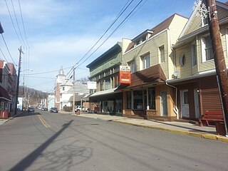
Capon Bridge is a town in eastern Hampshire County, West Virginia, United States, along the Northwestern Turnpike, approximately 20 miles (32 km) west of Winchester, Virginia. The population was 418 at the 2020 census. Originally known as "Glencoe", Capon Bridge was incorporated in 1902 by the Hampshire County Circuit Court. It is named because of the construction of the bridge over the Cacapon River at that place, the name of the river being derived from the Shawnee Cape-cape-de-hon, meaning "river of medicine water".

<span class="mw-page-title-main">Moorefield, West Virginia</span> Town in West Virginia, United States

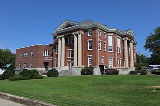
Moorefield is a town and the county seat of Hardy County, West Virginia, United States. It is located at the confluence of the South Branch Potomac River and the South Fork South Branch Potomac River. Moorefield was originally chartered in 1777; it was named for Conrad Moore, who owned the land upon which the town was laid out. The population was 2,527 at the 2020 census.

<span class="mw-page-title-main">Bridgeport, West Virginia</span> City in West Virginia, United States

Bridgeport is a city in eastern Harrison County, West Virginia, United States. The population was 9,325 at the 2020 census. It is part of the Clarksburg micropolitan area in North Central West Virginia. Bridgeport had its beginning in pre-American Revolutionary War times. In 1764, John Simpson entered the area and gave his name to Simpson Creek. Bridgeport was chartered in 1816.

<span class="mw-page-title-main">Ripley, West Virginia</span> City in West Virginia, United States

Ripley is a city in and the county seat of Jackson County, West Virginia, United States. The population was 3,074 at the 2020 census.

<span class="mw-page-title-main">Shepherdstown, West Virginia</span> Town in West Virginia, United States

Shepherdstown is a town in Jefferson County, West Virginia, United States, located in the lower Shenandoah Valley along the Potomac River. Home to Shepherd University, the town's population was 1,531 at the time of the 2020 census. The town was established in 1762 along with Romney; they are the oldest towns in West Virginia.

<span class="mw-page-title-main">Chapmanville, West Virginia</span> Town in West Virginia, United States

Chapmanville is a town in Logan County, West Virginia, United States. The population was 1,025 at the 2020 census. Chapmanville is named for Ned Chapman, an early settler who operated a store and post office. It was incorporated in 1947.

<span class="mw-page-title-main">Keyser, West Virginia</span> City in West Virginia, United States

Keyser is a city in and the county seat of Mineral County, West Virginia. It is part of the Cumberland, MD-WV Metropolitan Statistical Area. The population was 4,853 at the 2020 census.

<span class="mw-page-title-main">Piedmont, West Virginia</span> Town in West Virginia, United States

Piedmont is a town in Mineral County, West Virginia, United States. It is part of the Cumberland, MD-WV metropolitan statistical area. The population was 716 at the 2020 census. Piedmont was chartered in 1856 and the town is the subject of Colored People: A Memoir by Piedmont native Henry Louis Gates Jr.

<span class="mw-page-title-main">Berkeley Springs, West Virginia</span> Town in West Virginia, United States

Berkeley Springs is a town in, and the county seat of, Morgan County, West Virginia, United States, in the state's Eastern Panhandle. Berkeley Springs is also commonly used to refer to the area in and around the Town of Bath. In 1776, the Virginia Legislature incorporated a town around the springs and named it Bath. Since 1802, it has been referred to by the name of its original post office, Berkeley Springs. The population was 758 at the 2020 census. It is part of the Hagerstown–Martinsburg metropolitan area.

<span class="mw-page-title-main">Summersville, West Virginia</span> City in West Virginia, United States

Summersville is a city in Nicholas County, West Virginia, United States. The population was 3,459 at the 2020 census. It is the county seat of Nicholas County.

<span class="mw-page-title-main">Kingwood, West Virginia</span> City in West Virginia, United States

Kingwood is a city in and the county seat of Preston County, West Virginia, United States. The population was 2,980 at the 2020 census. The city sits within the Allegheny Mountains above the Cheat River valley. It is the home of the Preston County Buckwheat Festival, a county fair known for making buckwheat pancakes, as well as Hovatter’s Wildlife Zoo.

<span class="mw-page-title-main">Henniker, New Hampshire</span> Town in New Hampshire, United States

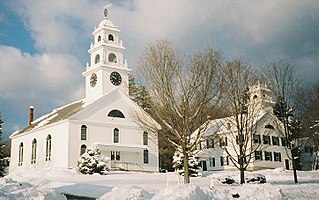
Henniker is a town in Merrimack County, New Hampshire, United States. As of the 2020 census, the reported total population of the town was 6,185, although the figure, 27.9% greater than the 2010 population, has been questioned by local officials. Henniker is home to New England College and Pats Peak Ski Area. Henniker is a college town and resort area, featuring both skiing and white-water kayaking.

References

  1. 1 2 3 U.S. Geological Survey Geographic Names Information System: Romney, West Virginia
  2. 1 2 3 "Town Council". Town of Romney website. Town of Romney Municipal Government. 2022. Retrieved August 5, 2022.
  3. "2019 U.S. Gazetteer, West Virginia Places". United States Census Bureau. September 5, 2019. Retrieved December 18, 2020.
  4. 1 2 3 4 "City and Town Population Totals: 2020-2021". Census.gov. US Census Bureau. Retrieved July 3, 2022.
  5. "Find a County". National Association of Counties. Retrieved June 7, 2011.
  6. "An Act for establishing the town of Romney, in the county of Hampshire, and for other purposes therein mentioned, Hening's Statutes at Large, Vol. VII, Chapter XII". vagenweb.org. Retrieved March 5, 2017.
  7. Burgesses, Virginia General Assembly House of (January 1, 1907). Journals of the House of Burgesses of Virginia, 1761-1765. Colonial Press, E. Waddey Company. pp. 164–165.
  8. Federal Writers' Project 1937 , p. 30.
  9. Miller & Maxwell 1913 , p. 562.
  10. Brannon 1976 , p. 261.
  11. Maier, p. 10.
  12. "History". Town of Romney website. Town of Romney Municipal Government. Retrieved April 17, 2023.
  13. "US Gazetteer files 2010". United States Census Bureau. Archived from the original on July 2, 2012. Retrieved January 24, 2013.
  14. Climate Summary for Romney, West Virginia
  15. "NOWData - NOAA Online Weather Data". National Oceanic and Atmospheric Administration. Retrieved October 14, 2023.
  16. "Summary of Monthly Normals 1991-2020". National Oceanic and Atmospheric Administration. Retrieved October 14, 2023.
  17. United States Census Bureau. "Census of Population and Housing" . Retrieved August 27, 2013.
  18. "Population Estimates". United States Census Bureau . Retrieved August 27, 2014.
  19. "U.S. Census website". United States Census Bureau . Retrieved January 24, 2013.