Meadow Bridge, West Virginia

Last updated

Meadow Bridge, West Virginia
Meadow Bridge WV Post Office 2022.jpg
Meadow Bridge Post Office in 2022
Fayette County West Virginia Incorporated and Unincorporated areas Meadow Bridge Highlighted.svg
Location of Meadow Bridge in Fayette County, West Virginia.
Coordinates: 37°51′45″N80°51′19″W / 37.86250°N 80.85528°W / 37.86250; -80.85528
Country United States
State West Virginia
County Fayette
Established1890
Area
[1]
  Total0.41 sq mi (1.05 km2)
  Land0.41 sq mi (1.05 km2)
  Water0.00 sq mi (0.00 km2)
Elevation
2,431 ft (741 m)
Population
 (2010) [2]
  Total379
  Estimate 
(2019) [3]
346
  Density852.22/sq mi (329.16/km2)
Time zone UTC-5 (Eastern (EST))
  Summer (DST) UTC-4 (EDT)
ZIP code
25976
Area code 304
FIPS code 54-52780 [4]
GNIS feature ID1543055 [5]

Meadow Bridge is a town in Fayette County, West Virginia, United States. The population was 379 at the 2010 census. The first settler of the area was John Gwin, closely followed by Dan Griffin.

Contents

The community took its name from a nearby bridge over Meadow Creek. [6]

History

Sometime in 1890, the first Meadow Bridge post office was established, and gave the area the name of Montrode. This was later changed to Clute, after the Virginia lumberman Theodore Clute, who came with the railroad to establish a sawmill in the area. With the help of the Meadow River Lumber company, and Theodore Clute, millions of feet of lumber were cut, and soon a town sprang up with shops and houses.

With industry in Meadow Bridge, on July 26, 1920, it was incorporated into an official town. Although industry came to the small town of Meadow Bridge, progress was slow and arduous. After several years of hard fighting, in 1924, they finally were able to bring a high school to the town, Meadow Bridge High School.

Part of their troubles was that they were isolated from the rest of Fayette County. That changed in 1937, when a seven-mile stretch of road was hard-surfaced, linking Meadow Bridge and the nearby town of Danese. In 1938, a road linking the town of Hinton and Rainelle ran through Meadow Bridge, linking all the towns together and, by extension, to Route 41. This finally gave Meadow Bridge a path to the western part of Fayette County.

Industry

In 1908, the Meadow River Lumber Company made a 20-mile stretch of track down to Meadow Bridge. Most say that this was the true beginning of Meadow Bridge becoming a town. After their purchase, the Hutchinson Lumber Company purchased a large tract of timberland in 1913.

Geography

Meadow Bridge is located at 37°51′45″N80°51′19″W / 37.86250°N 80.85528°W / 37.86250; -80.85528 (37.862399, -80.855169). [7]

According to the United States Census Bureau, the town has a total area of 0.41 square miles (1.06 km2), all land. [8]

Demographics

Historical population
CensusPop.Note
1930 476
1940 4770.2%
1950 59725.2%
1960 426−28.6%
1970 4290.7%
1980 53023.5%
1990 325−38.7%
2000 321−1.2%
2010 37918.1%
2019 (est.)346 [3] −8.7%
U.S. Decennial Census [9]

2010 census

As of the census [2] of 2010, there were 379 people, 165 households, and 97 families living in the town. The population density was 924.4 inhabitants per square mile (356.9/km2). There were 186 housing units at an average density of 453.7 per square mile (175.2/km2). The racial makeup of the town was 99.2% White, 0.3% Asian, 0.3% from other races, and 0.3% from two or more races. Hispanic or Latino of any race were 0.3% of the population.

There were 165 households, of which 24.2% had children under the age of 18 living with them, 41.8% were married couples living together, 12.1% had a female householder with no husband present, 4.8% had a male householder with no wife present, and 41.2% were non-families. 37.6% of all households were made up of individuals, and 24.9% had someone living alone who was 65 years of age or older. The average household size was 2.30 and the average family size was 3.01.

The median age in the town was 42.5 years. 22.7% of residents were under the age of 18; 6.2% were between the ages of 18 and 24; 24.8% were from 25 to 44; 23.5% were from 45 to 64; and 22.7% were 65 years of age or older. The gender makeup of the town was 47.5% male and 52.5% female.

2000 census

As of the census [4] of 2000, there were 321 people, 136 households, and 93 families living in the town. The population density was 791.3 inhabitants per square mile (302.3/km2). There were 175 housing units at an average density of 431.4 per square mile (164.8/km2). The racial makeup of the town was 100.00% White.

There were 136 households, out of which 29.4% had children under the age of 18 living with them, 47.1% were married couples living together, 18.4% had a female householder with no husband present, and 30.9% were non-families. 28.7% of all households were made up of individuals, and 14.7% had someone living alone who was 65 years of age or older. The average household size was 2.36 and the average family size was 2.83.

In the town, the population was spread out, with 22.1% under the age of 18, 11.2% from 18 to 24, 25.9% from 25 to 44, 24.0% from 45 to 64, and 16.8% who were 65 years of age or older. The median age was 39 years. For every 100 females, there were 76.4 males. For every 100 females age 18 and over, there were 83.8 males.

The median income for a household in the town was $23,194, and the median income for a family was $27,000. Males had a median income of $24,444 versus $14,625 for females. The per capita income for the town was $12,526. About 15.7% of families and 24.1% of the population were below the poverty line, including 34.5% of those under age 18 and 22.0% of those age 65 or over.

Related Research Articles

<span class="mw-page-title-main">Fayette County, West Virginia</span> County in West Virginia, United States

Fayette County is a county in the U.S. state of West Virginia. As of the 2020 census, the population was 40,488. Its county seat is Fayetteville. It is part of the Beckley, WV Metropolitan Statistical Area in Southern West Virginia.

<span class="mw-page-title-main">Fayette, Alabama</span> City in and county seat of Fayette County, Alabama

Fayette is a city and the county seat of Fayette County, Alabama, United States. The population was 4,619 at the 2010 census, down from 4,922 at the 2000 census.

<span class="mw-page-title-main">Fayette, Iowa</span> City in Iowa, United States

Fayette is a city in Fayette County, Iowa, United States. As of the 2020 census, the city population was 1,256. It was named after the Marquis de la Fayette, French hero of the American Revolutionary War. Fayette is the home of Upper Iowa University, a small private college. The Volga River State Recreation Area is located just north of Fayette, and many other parks and natural areas are nearby.

<span class="mw-page-title-main">Fayette, Maine</span> Town in the state of Maine, United States

Fayette is a town in Kennebec County, Maine, United States. The population was 1,160 as of the 2020 census. A popular recreation spot in central Maine, Fayette is part of the Winthrop Lakes Region.

<span class="mw-page-title-main">Brownfield, Maine</span> Town in the state of Maine, United States

Brownfield is a town in Oxford County, Maine, United States. The population was 1,631 at the 2020 census. Brownfield is home to the Stone Mountain Arts Center.

Bradley is a town in Penobscot County, Maine, United States. It is part of the Bangor Metropolitan Statistical Area. The population was 1,532 at the 2020 census. The village of Bradley is in the northwestern corner of the town.

<span class="mw-page-title-main">Searsmont, Maine</span> Town in the state of Maine, United States

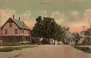
Searsmont is a town in Waldo County, Maine, United States. The population was 1,400 at the 2020 census.

<span class="mw-page-title-main">Essex, Missouri</span> City in Missouri, United States

Essex is a city in Stoddard County, Missouri, United States. The population was 472 at the 2010 census.

<span class="mw-page-title-main">Lumber Bridge, North Carolina</span> Town in North Carolina, United States

Lumber Bridge is a town in Robeson County, North Carolina, United States. The population was 94 at the 2010 census.

<span class="mw-page-title-main">Sylvania, Pennsylvania</span> Borough in Pennsylvania, United States

Sylvania is a borough in Bradford County, Pennsylvania, United States. It is part of Northeastern Pennsylvania. The population was 216 at the 2020 census. Children residing in the borough are assigned to attend the Troy Area School District.

<span class="mw-page-title-main">Fayette City, Pennsylvania</span> Borough in Pennsylvania, United States

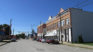
Fayette City is a borough in Fayette County, Pennsylvania, United States. The population was 502 at the 2020 census, a decline from the figure of 596 tabulated in 2010. It is served by the Belle Vernon Area School District. Some buildings in the town antedate 1820.

<span class="mw-page-title-main">Perry Township, Fayette County, Pennsylvania</span> Township in Pennsylvania, United States

Perry Township is a township in Fayette County, Pennsylvania, United States. The population was 2,339 at the 2020 census, a decline from the figure of 2,552 tabulated in 2010. The Frazier School District serves the township.

<span class="mw-page-title-main">Point Marion, Pennsylvania</span> Borough in Pennsylvania, United States

Point Marion is a borough in Fayette County, Pennsylvania, United States. The population was 1,152 at the 2020 census, a decline from the figure of 1,159 tabulated in 2010. It is served by the Albert Gallatin Area School District.

<span class="mw-page-title-main">Wharton Township, Fayette County, Pennsylvania</span> Township in Pennsylvania, United States

Wharton Township is a township in Fayette County, Pennsylvania, United States. The population was 3,360 at the 2020 census, down from 3,575 at the 2010 census. The Uniontown Area School District serves the region.

<span class="mw-page-title-main">Fayetteville, West Virginia</span> Town in West Virginia, United States

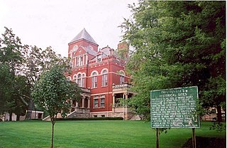
Fayetteville is a town in and the county seat of Fayette County, West Virginia, United States. The population was 2,887 at the 2020 census.

<span class="mw-page-title-main">Gauley Bridge, West Virginia</span> Town in West Virginia, United States

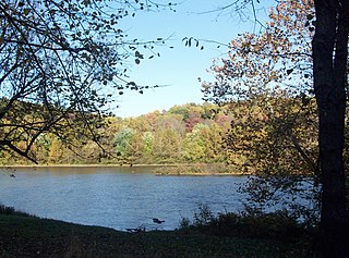
Gauley Bridge is a town in Fayette County, West Virginia, United States. The population was 614 at the 2010 census. The Kanawha River is formed at Gauley Bridge by the confluence of the New and Gauley Rivers. Two miles to the southwest of Gauley Bridge, in Glen Ferris, is Kanawha Falls, a popular stopping point on Midland Trail Scenic Highway.

<span class="mw-page-title-main">Rainelle, West Virginia</span> Town in West Virginia, United States

Rainelle is a town on the western edge of Greenbrier County, West Virginia, United States. It sits at the base of Sewell Mountain and Sims Mountain, and is bisected by the Meadow River. The only means of transportation to and from Rainelle are roads; primarily US 60 and WV 20, which merge on the western end of the town, and the James River and Kanawha Turnpike, which enters from the south. The population was 1,190 at the 2020 census.

<span class="mw-page-title-main">Fayette, Wisconsin</span> Town in Wisconsin, United States

Fayette is a town in Lafayette County, Wisconsin, United States. The population was 376 at the 2010 census. The unincorporated communities of Fayette and Yellowstone are located in the town.

<span class="mw-page-title-main">Bowler, Wisconsin</span> Village in Wisconsin, United States

Bowler is a village in Shawano County, Wisconsin, United States. The population was 302 at the 2010 census.

<span class="mw-page-title-main">New Holland, Ohio</span> Village in Ohio, United States

New Holland is a village in Fayette and Pickaway counties in Ohio, United States. The population was 804 at the 2020 census.

References

  1. "2019 U.S. Gazetteer Files". United States Census Bureau. Retrieved August 7, 2020.
  2. 1 2 "U.S. Census website". United States Census Bureau . Retrieved January 24, 2013.
  3. 1 2 "Population and Housing Unit Estimates". United States Census Bureau. May 24, 2020. Retrieved May 27, 2020.
  4. 1 2 "U.S. Census website". United States Census Bureau . Retrieved January 31, 2008.
  5. "US Board on Geographic Names". United States Geological Survey. October 25, 2007. Retrieved January 31, 2008.
  6. Kenny, Hamill (1945). West Virginia Place Names: Their Origin and Meaning, Including the Nomenclature of the Streams and Mountains. Piedmont, WV: The Place Name Press. pp. 408–409.
  7. "US Gazetteer files: 2010, 2000, and 1990". United States Census Bureau. February 12, 2011. Retrieved April 23, 2011.
  8. "US Gazetteer files 2010". United States Census Bureau. Archived from the original on January 25, 2012. Retrieved January 24, 2013.
  9. "Census of Population and Housing". Census.gov. Retrieved June 4, 2015.