Clearview, West Virginia

Last updated
Clearview, West Virginia
Ohio County West Virginia Incorporated and Unincorporated areas Clearview Highlighted.svg
Location of Clearview in Ohio County, West Virginia.
Coordinates: 40°8′32″N80°41′27″W / 40.14222°N 80.69083°W / 40.14222; -80.69083
Country United States
State West Virginia
County Ohio
Area
[1]
  Total0.40 sq mi (1.05 km2)
  Land0.40 sq mi (1.05 km2)
  Water0.00 sq mi (0.00 km2)
Elevation
1,093 ft (333 m)
Population
 (2010) [2]
  Total565
  Estimate 
(2019) [3]
482
  Density1,193.07/sq mi (460.08/km2)
Time zone UTC-5 (Eastern (EST))
  Summer (DST) UTC-4 (EDT)
Area code 304
FIPS code 54-15916 [4]
GNIS feature ID1537397 [5]
Website https://clearviewvillagewv.business.site/

Clearview is a village in Ohio County, West Virginia, United States. It is part of the Wheeling, West Virginia Metropolitan Statistical Area. The population was 565 at the 2010 census.

Contents

Geography

Clearview is located at 40°8′32″N80°41′27″W / 40.14222°N 80.69083°W / 40.14222; -80.69083 (40.142204, -80.690849). [6]

According to the United States Census Bureau, the village has a total area of 0.42 square miles (1.09 km2), all land. [7]

Demographics

Historical population
CensusPop.Note
1960 520
1970 512−1.5%
1980 74044.5%
1990 622−15.9%
2000 590−5.1%
2010 565−4.2%
2019 (est.)482 [3] −14.7%
U.S. Decennial Census [8]

2010 census

At the 2010 census there were 565 people, 221 households, and 164 families living in the village. The population density was 1,345.2 inhabitants per square mile (519.4/km2). There were 226 housing units at an average density of 538.1 per square mile (207.8/km2). The racial makeup of the village was 99.3% White, 0.4% African American, 0.2% Pacific Islander, and 0.2% from two or more races. Hispanic or Latino of any race were 0.4%. [2]

Of the 221 households 30.8% had children under the age of 18 living with them, 66.1% were married couples living together, 5.4% had a female householder with no husband present, 2.7% had a male householder with no wife present, and 25.8% were non-families. 23.1% of households were one person and 12.2% were one person aged 65 or older. The average household size was 2.56 and the average family size was 3.01.

The median age in the village was 45.6 years. 22.7% of residents were under the age of 18; 5.7% were between the ages of 18 and 24; 20.3% were from 25 to 44; 37.3% were from 45 to 64; and 14% were 65 or older. The gender makeup of the village was 50.8% male and 49.2% female.

2000 census

At the 2000 census there were 590 people, 223 households, and 179 families living in the village. The population density was 1,502.1 people per square mile (584.1/km2). There were 231 housing units at an average density of 588.1 per square mile (228.7/km2). The racial makeup of the village was 99.66% White and 0.34% Asian. Hispanic or Latino of any race were 0.17%. [4]

Of the 223 households 33.2% had children under the age of 18 living with them, 72.6% were married couples living together, 7.2% had a female householder with no husband present, and 19.3% were non-families. 18.4% of households were one person and 11.7% were one person aged 65 or older. The average household size was 2.65 and the average family size was 2.99.

The age distribution was 23.9% under the age of 18, 4.9% from 18 to 24, 28.3% from 25 to 44, 26.1% from 45 to 64, and 16.8% 65 or older. The median age was 42 years. For every 100 females there were 89.1 males. For every 100 females age 18 and over, there were 84.8 males.

The median household income was $41,250 and the median family income was $45,000. Males had a median income of $32,250 versus $23,750 for females. The per capita income for the village was $19,404. About 6.3% of families and 8.3% of the population were below the poverty line, including 9.2% of those under age 18 and 4.3% of those age 65 or over.

Related Research Articles

<span class="mw-page-title-main">Meadowbrook, Alabama</span> Census-designated place & Unincorporated community in Alabama, United States

Meadowbrook is an unincorporated community and census-designated place (CDP) in Shelby County, Alabama, United States. At the 2020 census, the population was 9,688. It is part of the Birmingham metropolitan area.

<span class="mw-page-title-main">Ragland, Alabama</span> Town in Alabama, United States

Ragland is a town in St. Clair County, Alabama, United States southeast of Ashville. It incorporated in 1899. At the 2020 census, the population was 1,693, up slightly from 1,639 in 2010. It is part of the Birmingham-Hoover-Cullman Combined Statistical Area.

<span class="mw-page-title-main">Robeline, Louisiana</span> Village

Robeline is a village in western Natchitoches Parish, Louisiana, United States. The population was 183 at the 2000 census. It is part of the Natchitoches Micropolitan Statistical Area.

<span class="mw-page-title-main">Sand Beach Township, Michigan</span> Civil township in Michigan, United States

Sand Beach Township is a civil township of Huron County in the U.S. state of Michigan. The population was 1,470 at the 2000 census.

<span class="mw-page-title-main">Miramiguoa Park, Missouri</span> Village in Missouri, United States

Miramiguoa Park is a village in Franklin County, Missouri, United States. The population was 120 at the 2010 census.

<span class="mw-page-title-main">Country Life Acres, Missouri</span> Village in Missouri, United States

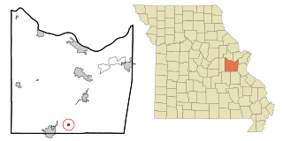
Country Life Acres is a village in St. Louis County, Missouri, United States. The population was 74 at the 2010 census.

<span class="mw-page-title-main">Murdock, Nebraska</span> Village in Nebraska, United States

Murdock is a village in Cass County, Nebraska, United States. The population was 270 according to the 2020 census.

<span class="mw-page-title-main">Morrisonville, New York</span> Census-designated place in New York, United States

Morrisonville is a hamlet and census-designated place in Clinton County, New York, United States. The population was 1,545 at the 2010 census.

<span class="mw-page-title-main">Mack South, Ohio</span> Former CDP in Ohio, United States

Mack South was a census-designated place (CDP) in Hamilton County, Ohio, United States. The population was 5,837 at the 2000 census. For the 2010 census, it was merged into the Mack CDP.

<span class="mw-page-title-main">Rayland, Ohio</span> Village in Ohio, United States

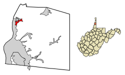
Rayland is a village in southern Jefferson County, Ohio, United States, along the Ohio River. The population was 389 at the 2020 census. It is part of the Weirton–Steubenville metropolitan area.

<span class="mw-page-title-main">Gann, Ohio</span> Village in Ohio, United States

Brinkhaven, once known as Mount Holly and Gann, is a village in Knox County, Ohio, United States. The population was 114 at the 2020 census.

<span class="mw-page-title-main">Kirkersville, Ohio</span> Village in Ohio, United States

Kirkersville is a village in Licking County, Ohio, United States, along the South Fork of the Licking River. The population was 471 at the 2020 census.

<span class="mw-page-title-main">Darbyville, Ohio</span> Village in Ohio, United States

Darbyville is a village in Pickaway County, Ohio, United States. The population was 186 at the 2020 census.

<span class="mw-page-title-main">Clearview, Oklahoma</span> Town in Oklahoma, United States

Clearview is a town in Okfuskee County, Oklahoma, United States. The population was 41 at the 2020 Census. It was historically an all-black freedmen's town and was platted by the Lincoln Townsite Company and designated as Lincoln.

<span class="mw-page-title-main">Venango Township, Butler County, Pennsylvania</span> Township in Pennsylvania, United States

Venango Township is a township that is located in Butler County, Pennsylvania, United States. The population was 869 at the time of the 2020 census.

<span class="mw-page-title-main">Oak Grove Village, Missouri</span> Village in Missouri, United States

Oak Grove Village is a village in Franklin County, Missouri, United States. The population was 509 at the 2010 census.

<span class="mw-page-title-main">Bay City, Wisconsin</span> Village in Wisconsin, United States

Bay City is a village on the Mississippi River in Pierce County, Wisconsin, United States. The population was 500 at the 2010 census.

<span class="mw-page-title-main">Weyerhaeuser, Wisconsin</span> Village in Wisconsin, United States

Weyerhaeuser is a village in Rusk County, Wisconsin, United States. The population was 238 at the 2010 census.

Clearview Acres is a census-designated place (CDP) in Sweetwater County, Wyoming, United States. The population was 795 at the 2010 census.

<span class="mw-page-title-main">Verona, Ohio</span> Village in Ohio, United States

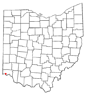
Verona is a village in Montgomery and Preble counties in the U.S. state of Ohio. The population was 403 at the 2020 census. It is part of the Dayton Metropolitan Statistical Area.

References

  1. "2019 U.S. Gazetteer Files". United States Census Bureau. Retrieved August 7, 2020.
  2. 1 2 "U.S. Census website". United States Census Bureau . Retrieved 2013-01-24.
  3. 1 2 "Population and Housing Unit Estimates". United States Census Bureau. May 24, 2020. Retrieved May 27, 2020.
  4. 1 2 "U.S. Census website". United States Census Bureau . Retrieved 2008-01-31.
  5. "US Board on Geographic Names". United States Geological Survey. 2007-10-25. Retrieved 2008-01-31.
  6. "US Gazetteer files: 2010, 2000, and 1990". United States Census Bureau. 2011-02-12. Retrieved 2011-04-23.
  7. "US Gazetteer files 2010". United States Census Bureau. Archived from the original on 2012-07-02. Retrieved 2013-01-24.
  8. "Census of Population and Housing". Census.gov. Retrieved June 4, 2015.