Pleasant Valley, Marion County, West Virginia

Last updated
Pleasant Valley, West Virginia
Flag of Pleasant Valley West Virginia (2021-Present).svg
Marion County West Virginia Incorporated and Unincorporated areas Pleasant Valley Highlighted.svg
Location of Pleasant Valley in Marion County, West Virginia.
Coordinates: 39°27′5″N80°8′57″W / 39.45139°N 80.14917°W / 39.45139; -80.14917 Coordinates: 39°27′5″N80°8′57″W / 39.45139°N 80.14917°W / 39.45139; -80.14917
Country United States
State West Virginia
County Marion
Government
  Type Strong Mayor-Council Government [1]
  MayorEmily Haddix
Area
[2]
  Total3.41 sq mi (8.82 km2)
  Land3.23 sq mi (8.37 km2)
  Water0.18 sq mi (0.45 km2)
Elevation
1,030 ft (314 m)
Population
 (2020) [3]
  Total3,506
  Estimate 
(2021) [3]
3,492
  Density972.14/sq mi (375.35/km2)
Time zone UTC-5 (Eastern (EST))
  Summer (DST) UTC-4 (EDT)
ZIP codes
26554-26555
Area code 304
FIPS code 54-64228 [4]
GNIS feature ID1555370 [5]
Website http://www.cityofpleasantvalley.com

Pleasant Valley is a city in Marion County, West Virginia, United States. The population was 3,506 at the 2020 census. [3]

Contents

Geography

Pleasant Valley is located at 39°27′5″N80°8′57″W / 39.45139°N 80.14917°W / 39.45139; -80.14917 (39.451522, -80.149085). [6] It is immediately south of the larger city and county seat of Fairmont, West Virginia. The city is also adjacent to the Tygart Valley River.

According to the United States Census Bureau, the city has a total area of 3.41 square miles (8.83 km2), of which 3.23 square miles (8.37 km2) is land and 0.18 square miles (0.47 km2) is water. [7]

Transportation

Demographics

Historical population
CensusPop.Note
2000 3,124
2010 3,1490.8%
2020 3,50611.3%
2021 (est.)3,492 [3] −0.4%
U.S. Decennial Census [9]

The median income for a household in the city was $37,931, and the median income for a family was $47,330. Full-time, year-round male workers had a median income of $45,234 versus $37,132 for female workers. The per capita income for the city was $22,335. About 9.7% of families and 16.3% of the population were below the poverty line, including 19.8% of those under age 18 and 8.4% of those age 65 or over.

2010 census

As of the census [10] of 2010, there were 3,149 people, 1,401 households, and 870 families living in the city. The population density was 974.9 inhabitants per square mile (376.4/km2). There were 1,513 housing units at an average density of 468.4 per square mile (180.9/km2). The racial makeup of the city was 95.9% White, 1.4% African American, 0.1% Native American, 1.1% Asian, 0.2% from other races, and 1.3% from two or more races. Hispanic or Latino of any race were 0.6% of the population.

There were 1,401 households, of which 26.1% had children under the age of 18 living with them, 47.0% were married couples living together, 11.1% had a female householder with no husband present, 4.0% had a male householder with no wife present, and 37.9% were non-families. 30.8% of all households were made up of individuals, and 12.4% had someone living alone who was 65 years of age or older. The average household size was 2.21 and the average family size was 2.76.

The median age in the city was 40.5 years. 21.2% of residents were under the age of 18; 8% were between the ages of 18 and 24; 26.2% were from 25 to 44; 28.1% were from 45 to 64; and 16.6% were 65 years of age or older. The gender makeup of the city was 48.9% male and 51.1% female.

Related Research Articles

<span class="mw-page-title-main">Marion County, West Virginia</span> County in West Virginia, United States

Marion County is a county in the U.S. state of West Virginia. As of the 2020 census, the population was 56,205. Its county seat is Fairmont. The county was named in honor of General Francis Marion, known to history as "The Swamp Fox".

<span class="mw-page-title-main">Rainbow, California</span> Census designated place in California, United States

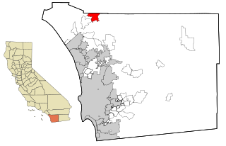
Rainbow is a census designated place (CDP) in northern San Diego County in the U.S. state of California. The population was 1,832 at the 2010 census, down from 2,026 at the 2000 census.

<span class="mw-page-title-main">Fairmont City, Illinois</span> Village in Illinois, United States

Fairmont City is a village in St. Clair and Madison counties, Illinois, United States. The population was 2,265 at the 2020 census, down from 2,635 in 2010. In the 1990s Fairmont City's Hispanic population doubled, and as of 2020, over 79% of the population was of Hispanic descent.

<span class="mw-page-title-main">Pleasant Hill, Iowa</span> City in Iowa, United States

Pleasant Hill is a city in Polk County, Iowa, United States. The population was 10,147 at the time of the 2020 census. It is part of the Des Moines metropolitan area. As of July 2005, Pleasant Hill was assigned a ZIP code, 50327.

<span class="mw-page-title-main">Riverdale, Iowa</span> City in Iowa, United States

Riverdale is a city in Scott County, Iowa, United States. The population was 379 at the time of the 2020 census.

<span class="mw-page-title-main">Chatham, Louisiana</span> Town in Louisiana, United States

Chatham is a town in Jackson Parish, Louisiana, United States. The population was 557 at the 2010 census. It is part of the Ruston Micropolitan Statistical Area.

<span class="mw-page-title-main">Grasston, Minnesota</span> City in Minnesota, United States

Grasston is a city in Kanabec County, Minnesota, United States. The population was 158 at the 2010 census.

<span class="mw-page-title-main">Fairmont, Minnesota</span> City in Minnesota, United States

Fairmont is a city in and the county seat of Martin County, Minnesota, United States. The population was 10,487 at the 2020 census.

<span class="mw-page-title-main">Fairmont, Nebraska</span> Village in Nebraska, United States

Fairmont is a village in Fillmore County, Nebraska, United States. The population was 602 at the 2020 census.

<span class="mw-page-title-main">Pleasant Valley, Missouri</span> Place in Missouri, United States

Pleasant Valley is a city in Clay County, Missouri, United States. The population was 2,743 at the 2020 census. It is part of the Kansas City metropolitan area.

<span class="mw-page-title-main">Champ, Missouri</span> Village in Missouri, United States

Champ is a village in St. Louis County, Missouri, United States. The population was 10 at the 2020 census.

<span class="mw-page-title-main">Pleasant City, Ohio</span> Village in Ohio, United States

Pleasant City is a village in Guernsey County, Ohio, United States. The population was 447 at the 2010 census.

<span class="mw-page-title-main">Johnstown, Ohio</span> City in Ohio, United States

Johnstown is a city in Licking County, Ohio, United States. The population was 5,182 at the 2020 census.

<span class="mw-page-title-main">Prospect, Ohio</span> Village in Ohio, United States

Prospect is a village in Marion County, Ohio, United States. The population was 1,112 at the 2010 census. The village is served by Elgin Local School District. Prospect has a public library, a branch of Marion Public Library.

<span class="mw-page-title-main">Forest Park, Oklahoma</span> Town in Oklahoma, United States

Forest Park is a town in Oklahoma County, Oklahoma, United States, and a part of the Oklahoma City metropolitan area. The population was 998 at the 2010 census.

<span class="mw-page-title-main">Hooversville, Pennsylvania</span> Borough in Pennsylvania, United States

Hooversville is a borough in Somerset County, Pennsylvania, United States. It is part of the Johnstown, Pennsylvania, Metropolitan Statistical Area. The population was 626 at the 2020 census.

<span class="mw-page-title-main">Carmine, Texas</span> City in Texas, United States

Carmine is a city in Fayette County, Texas, United States. The population was 250 at the 2010 census.

<span class="mw-page-title-main">Liberty City, Texas</span> Census-designated place in Texas, United States

Liberty City is a census-designated place (CDP) in Gregg County, Texas, United States. The population was 2,721 at the 2020 census, up from 2,351 at the 2010 census.

<span class="mw-page-title-main">White Hall, West Virginia</span> Town in West Virginia, United States

White Hall is a town in Marion County, West Virginia, United States. The population was 706 at the 2020 census. Incorporated in 1989, White Hall is adjacent to the county seat, Fairmont, and is part of the Fairmont, West Virginia, Micropolitan Statistical Area. White Hall has many different stores and restaurants.

<span class="mw-page-title-main">Belmont, West Virginia</span> Town in West Virginia, United States

Belmont is a town in Pleasants County, West Virginia, United States. It is part of the Parkersburg-Marietta-Vienna, WV-OH Metropolitan Statistical Area. The population was 872 at the 2020 census.

References

  1. "Elected Officials". City of Pleasant Valley, West Virginia. Retrieved 31 March 2012.
  2. "2019 U.S. Gazetteer Files". United States Census Bureau. Retrieved August 7, 2020.
  3. 1 2 3 4 Bureau, US Census. "City and Town Population Totals: 2020-2021". Census.gov. US Census Bureau. Retrieved 3 July 2022.
  4. "U.S. Census website". United States Census Bureau . Retrieved 2008-01-31.
  5. "US Board on Geographic Names". United States Geological Survey. 2007-10-25. Retrieved 2008-01-31.
  6. "US Gazetteer files: 2010, 2000, and 1990". United States Census Bureau. 2011-02-12. Retrieved 2011-04-23.
  7. "US Gazetteer files 2010". United States Census Bureau. Archived from the original on 2012-01-25. Retrieved 2013-01-24.
  8. "Location Identifiers". Archived from the original on 25 June 2012. Retrieved 31 March 2012.
  9. "Census of Population and Housing". Census.gov. Retrieved June 4, 2015.
  10. "U.S. Census website". United States Census Bureau . Retrieved 2013-01-24.