West Milford, West Virginia

Last updated

West Milford, West Virginia
Flag of West Milford, West Virginia.svg
Harrison County West Virginia Incorporated and Unincorporated areas West Milford Highlighted.svg
Location of West Milford in Harrison County, West Virginia.
Coordinates: 39°12′9″N80°24′13″W / 39.20250°N 80.40361°W / 39.20250; -80.40361
Country United States
State West Virginia
County Harrison
Area
[1]
  Total0.53 sq mi (1.38 km2)
  Land0.53 sq mi (1.38 km2)
  Water0.00 sq mi (0.00 km2)
Elevation
1,014 ft (309 m)
Population
 (2020) [2]
  Total452
  Estimate 
(2021) [2]
447
  Density1,143.13/sq mi (441.05/km2)
Time zone UTC-5 (Eastern (EST))
  Summer (DST) UTC-4 (EDT)
ZIP code
26451
Area code 304
FIPS code 54-85924 [3]
GNIS feature ID1555949 [4]
Website local.wv.gov/westmilford/Pages/default.aspx

West Milford is a town in Harrison County, West Virginia, United States. The population was 452 at the 2020 census. [2]

Contents

West Milford was named on account of there being a mill on the ford of the West Fork River. [5] [6]

Geography

West Milford is located at 39°12′9″N80°24′13″W / 39.20250°N 80.40361°W / 39.20250; -80.40361 (39.202490, -80.403719), [7] along the West Fork River in southern Harrison County. [8]

According to the United States Census Bureau, the town has a total area of 0.53 square miles (1.37 km2), all land. [9]

Demographics

Historical population
CensusPop.Note
1890 210
1900 187−11.0%
1910 21213.4%
1930 349
1940 38911.5%
1950 4013.1%
1960 367−8.5%
1970 356−3.0%
1980 51043.3%
1990 5191.8%
2000 65125.4%
2010 630−3.2%
2020 452−28.3%
2021 (est.)447 [2] −1.1%
U.S. Decennial Census [10]

2010 census

As of the census [11] of 2010, there were 630 people, 263 households, and 180 families living in the town. The population density was 1,188.7 inhabitants per square mile (459.0/km2). There were 279 housing units at an average density of 526.4 per square mile (203.2/km2). The racial makeup of the town was 96.5% White, 0.2% African American, 0.2% Native American, 0.2% Asian, and 3.0% from two or more races. Hispanic or Latino of any race were 0.5% of the population.

There were 263 households, of which 34.6% had children under the age of 18 living with them, 52.5% were married couples living together, 10.3% had a female householder with no husband present, 5.7% had a male householder with no wife present, and 31.6% were non-families. 27.0% of all households were made up of individuals, and 11.8% had someone living alone who was 65 years of age or older. The average household size was 2.40 and the average family size was 2.91.

The median age in the town was 38.8 years. 25.1% of residents were under the age of 18; 5.8% were between the ages of 18 and 24; 29.7% were from 25 to 44; 26% were from 45 to 64; and 13.5% were 65 years of age or older. The gender makeup of the town was 51.6% male and 48.4% female.

2000 census

As of the census [3] of 2000, there were 651 people, 236 households, and 189 families living in the town. The population density was 1,223.1 inhabitants per square mile (474.2/km2). There were 267 housing units at an average density of 501.7 per square mile (194.5/km2). The racial makeup of the town was 99.54% White, 0.31% Native American, and 0.15% from two or more races. Hispanic or Latino of any race were 0.46% of the population.

There were 236 households, out of which 40.7% had children under the age of 18 living with them, 64.0% were married couples living together, 11.0% had a female householder with no husband present, and 19.9% were non-families. 16.5% of all households were made up of individuals, and 6.8% had someone living alone who was 65 years of age or older. The average household size was 2.76 and the average family size was 3.07.

In the town, the population was spread out, with 28.0% under the age of 18, 7.5% from 18 to 24, 32.6% from 25 to 44, 20.4% from 45 to 64, and 11.5% who were 65 years of age or older. The median age was 35 years. For every 100 females, there were 94.9 males. For every 100 females age 18 and over, there were 89.1 males.

The median income for a household in the town was $32,250, and the median income for a family was $34,583. Males had a median income of $30,000 versus $22,292 for females. The per capita income for the town was $16,527. About 6.7% of families and 10.7% of the population were below the poverty line, including 8.0% of those under age 18 and 8.5% of those age 65 or over.

Related Research Articles

<span class="mw-page-title-main">Bethany, West Virginia</span> Town in West Virginia, United States

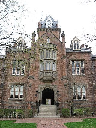
Bethany is a town in southern Brooke County, West Virginia, United States. The population was 756 at the 2020 census. It is part of the Weirton–Steubenville metropolitan area. It is best known as the home of Bethany College, a private liberal arts college that was the first institution of higher education in what is now West Virginia.

<span class="mw-page-title-main">Sand Fork, West Virginia</span> Town in West Virginia, United States

Sand Fork is a town in Gilmer County, West Virginia, United States. The population was 182 at the 2020 census. It is located along the Little Kanawha River, at the mouth of the Sand Fork.

<span class="mw-page-title-main">Rupert, West Virginia</span> Town in West Virginia, United States

Rupert is a town in Greenbrier County, West Virginia, United States. The population was 881 at the 2020 census.

<span class="mw-page-title-main">Anmoore, West Virginia</span> Town in West Virginia, United States

Anmoore is a town in Harrison County, West Virginia, United States. It is located at the intersection of WV 58 and Interstate 79. The population was 514 at the 2020 census.

<span class="mw-page-title-main">Lumberport, West Virginia</span> Town in West Virginia, United States

Lumberport is a town in Harrison County, located in northern West Virginia, United States. The population was 720 at the 2020 census.

<span class="mw-page-title-main">Stonewood, West Virginia</span> City in West Virginia, United States

Stonewood is a city in Harrison County, West Virginia, United States. The population was 1,810 at the 2020 census.

<span class="mw-page-title-main">Belle, West Virginia</span> Town in West Virginia, United States

Belle is a town in Kanawha County, West Virginia, United States, situated along the Kanawha River. The population was 1,171 at the 2020 census. Belle was incorporated on December 13, 1958, by the Kanawha County Circuit Court. It is the home of the Belle Bulldogs Elementary School.

<span class="mw-page-title-main">Jane Lew, West Virginia</span> Town in West Virginia, United States

Jane Lew is a town in Lewis County, West Virginia, United States. The population was 409 at the time of the 2020 census.

<span class="mw-page-title-main">Fairview, West Virginia</span> Town in West Virginia, United States

Fairview is a town in Marion County, West Virginia, United States. The population was 374 at the 2020 census.

<span class="mw-page-title-main">Carpendale, West Virginia</span> Town in West Virginia, United States

Carpendale is a town in Mineral County, West Virginia, United States, and part of the Cumberland, MD-WV Metropolitan Statistical Area'. The population was 861 at the 2020 census. Carpendale was incorporated on January 2, 1990, by the Circuit Court. The town is a combination of three subdivisions of which its name reflects: Carpenters Addition, Millerdale I, and Millerdale II. There are no stores in Carpendale and there is only one road in and out of the town.

<span class="mw-page-title-main">Elk Garden, West Virginia</span> Town in West Virginia, United States

Elk Garden is a town in Mineral County, West Virginia, United States. It is part of the 'Cumberland, MD-WV Metropolitan Statistical Area'. The population was 211 at the 2020 census. Elk Garden High School was consolidated into Keyser High School in 1997. However the Primary School is still in session, offering classes from Pre-Kindergarten through the fifth grade. The school mascot is the Elk Garden Stags. Elk Garden was incorporated in 1890 by the Mineral County Circuit Court. It is named for an elk lick near the original town site.

<span class="mw-page-title-main">Gilbert, West Virginia</span> Town in West Virginia, United States

Gilbert is a town in Mingo County, West Virginia, United States, along the Guyandotte River. The population was 333 at the 2020 census. Gilbert was incorporated in 1918 and named for Gilbert Creek, which derives its name from the name of an early traveler in the area who was killed by Native Americans. Gilbert is known nationwide for the Hatfield-McCoy ATV Trails that are located in the area. There are a number of lodges and restaurants in Gilbert.

<span class="mw-page-title-main">Peterstown, West Virginia</span> Town in West Virginia, United States

Peterstown is a town in Monroe County, West Virginia, United States. The population was 456 at the 2020 census.

<span class="mw-page-title-main">Belmont, West Virginia</span> Town in West Virginia, United States

Belmont is a town in Pleasants County, West Virginia, United States. It is part of the Parkersburg–Vienna metropolitan area. The population was 872 at the 2020 census. Belmont was incorporated on April 19, 1946, by the Circuit Court of Pleasants County. The city was named for the beautiful hills in the area.

<span class="mw-page-title-main">Newburg, West Virginia</span> Town in West Virginia, United States

Newburg is a town in western Preston County, West Virginia, United States. The population was 275 at the 2020 census. It is part of the Morgantown metropolitan area.

<span class="mw-page-title-main">Poca, West Virginia</span> Town in West Virginia, United States

Poca is a town in Putnam County, West Virginia, United States. The population was 875 at the 2020 census. It is part of the Huntington–Ashland metropolitan area. The town derives its name from the Pocatalico River.

<span class="mw-page-title-main">Huttonsville, West Virginia</span> Town in West Virginia, United States

Huttonsville is a town in Randolph County, West Virginia, United States, along the Tygart Valley River. The population was 163 at the 2020 census.

<span class="mw-page-title-main">Montrose, West Virginia</span> Town in West Virginia, United States

Montrose is a town in Randolph County, West Virginia, United States. The population was 141 at the 2020 census.

<span class="mw-page-title-main">Hambleton, West Virginia</span> Town in West Virginia, United States

Hambleton is a town in Tucker County, West Virginia, United States. The population was 216 at the 2020 census. Hambleton was established in 1889, but not incorporated until 1905. It was named by then United States Senator Stephen B. Elkins in honor of a stockholder by this name in the West Virginia Central Railroad Company. The town was previously known as Hulings.

<span class="mw-page-title-main">Hendricks, West Virginia</span> Town in West Virginia, United States

Hendricks is a town in Tucker County, West Virginia, United States. The population was 226 at the 2020 census. The Blackwater River and the Dry Fork join at Hendricks to form the Black Fork, a principal tributary of the Cheat River.

References

  1. "2019 U.S. Gazetteer Files". United States Census Bureau. Retrieved August 7, 2020.
  2. 1 2 3 4 Bureau, US Census. "City and Town Population Totals: 2020-2021". Census.gov. US Census Bureau. Retrieved July 2, 2022.
  3. 1 2 "U.S. Census website". United States Census Bureau . Retrieved January 31, 2008.
  4. "US Board on Geographic Names". United States Geological Survey. October 25, 2007. Retrieved January 31, 2008.
  5. Capace, Nancy (1999). Encyclopedia of West Virginia. North American Book Dist LLC. p. 197. ISBN   978-0-403-09843-9.
  6. Kenny, Hamill (1945). West Virginia Place Names: Their Origin and Meaning, Including the Nomenclature of the Streams and Mountains. Piedmont, WV: The Place Name Press. p. 668.
  7. "US Gazetteer files: 2010, 2000, and 1990". United States Census Bureau. February 12, 2011. Retrieved April 23, 2011.
  8. DeLorme (1997). West Virginia Atlas & Gazetteer. Yarmouth, Maine: DeLorme. p.36. ISBN   0-89933-246-3.
  9. "US Gazetteer files 2010". United States Census Bureau . Retrieved January 24, 2013.
  10. "Census of Population and Housing". Census.gov. Retrieved June 4, 2015.
  11. "U.S. Census website". United States Census Bureau . Retrieved January 24, 2013.