Piedmont, West Virginia

Last updated

Town of Piedmont, West Virginia
Piedmont, WV downtown.jpg
Downtown Piedmont in January 2014
Mineral County West Virginia Incorporated and Unincorporated areas Piedmont Highlighted.svg
Location of Piedmont in Mineral County, West Virginia.
Coordinates: 39°28′49″N79°02′53″W / 39.48028°N 79.04806°W / 39.48028; -79.04806
CountryUnited States
State West Virginia
County Mineral
Government
  TypeMayor/Council
   Mayor Paula Boggs [1]
Area
[2]
  Total0.38 sq mi (0.99 km2)
  Land0.38 sq mi (0.99 km2)
  Water0.00 sq mi (0.00 km2)
Elevation
1,201 ft (366 m)
Population
 (2020) [3]
  Total716
  Estimate 
(2021) [3]
707
  Density2,104.99/sq mi (812.16/km2)
Time zone UTC-5 (EST)
  Summer (DST) UTC-4 (EDT)
ZIP code
26750
Area code 304
FIPS code 54-63604 [4]
GNIS feature ID2391360 [5]
Website local.wv.gov/Piedmont/Pages/default.aspx

Piedmont is a town in Mineral County, West Virginia, United States. It is part of the Cumberland, MD-WV metropolitan statistical area. The population was 716 at the 2020 census. [3] Piedmont was chartered in 1856 and the town is the subject of Colored People: A Memoir [6] by Piedmont native Henry Louis Gates Jr.

Contents

Geography

As its name suggests, Piedmont is located at the base of a mountain, in this instance the foot of the Allegheny Front, the eastern edge of the Allegheny Mountains or Appalachian Plateau, on the south (West Virginia) side of the North Branch of the Potomac River.

Piedmont is located at 39°28′49″N79°2′53″W / 39.48028°N 79.04806°W / 39.48028; -79.04806 (39.480232, -79.048086). [7] According to the United States Census Bureau, the town has a total area of 0.38 square miles (0.98 km2), all land. [8]

Transportation

Route 46 eastbound in Piedmont 2016-06-18 07 24 07 View east along West Virginia State Route 46 (Ashfield Street) just south of the North Branch Potomac River in Piedmont, Mineral County, West Virginia.jpg
Route 46 eastbound in Piedmont

The only significant highway directly serving Piedmont is West Virginia Route 46. Route 46 continues west across the North Branch Potomac River into Westernport, Maryland. To the east, Route 46 heads to Keyser, where it has a junction with U.S. Route 220.

History

The Town of Piedmont is situated in the Allegheny Front mountain range along the North Branch of the Potomac River. A century prior to the chartering of Piedmont, the area was opened for European settlement with the creation of Hampshire County in 1754 by the colonial government in Virginia. The region was the scene of hostile interactions between European settlers and pro-French Native Americans during the French and Indian War. Owing to its location and natural resources, the Piedmont area attracted German, Scotch-Irish, Swiss, English, and Italian immigrants, making the region more diverse than the primarily English-American Hampshire County. These cultural differences within the county, as well as growing population in the years leading up to the Civil War would later contribute to the formation of a new county.

The village of Piedmont was settled by people seeking to extract coal from the Allegheny Front mountain range which extends for several miles to the south of the town. Its strategic location at the intersection of George's Creek Valley, an industrial center in neighboring Maryland, made Piedmont a desirable location for a depot on the Baltimore and Ohio Railroad as it pushed west on its route to Wheeling and the Ohio River. The original main line of the B&O railroad reached the site of Piedmont on July 21, 1851. Two years later in 1853, the railroad reached the Ohio River at Wheeling, connecting Baltimore, Maryland with a direct route leading to the rapidly-growing Northwest Territory states. The line through Piedmont remains a segment of the B&O system, now part of CSX Transportation.

With the arrival of the B&O and the building of a roundhouse and rail yard, the Town of Piedmont was chartered in 1856. [9] During the American Civil War (1861–1865), the town of Piedmont was frequently raided by the McNeill's Rangers in an effort by the Confederates to disrupt B&O train service. Despite the interruption of the war, the region continued to develop new industrial and commercial institutions, leading to the creation of Mineral County in 1866 (separated from Hampshire County). [10] Along with neighboring Grant County, these two new counties were the first created in the state of West Virginia which itself was separated from Virginia in 1863. In 1888, William Luke established the West Virginia Paper Company (now Verso Luke Mill) on 50 acres (20 ha) of Maryland land known as West Piedmont (now Luke, Maryland, adjacent to the larger town of Westernport, Maryland), fueling further development of the region.

Notable residents of Piedmont have included U.S. Senator Henry Gassaway Davis who worked as a storekeeper and railroad agent before opening the region's largest coal mines on the "Big Vein" on the Allegheny Front. [10] Leslie Thrasher, a noted illustrator whose work was featured on the covers of Liberty magazine and the Saturday Evening Post was born in Piedmont on September 15, 1889. Jazz musician and composer Don Redman was born in Piedmont on July 29, 1900. Henry Louis Gates, a professor of African-American history at Harvard University, was raised in Piedmont, an experience he described in his 1994 book Colored People. [6] Steve Whiteman, lead singer for the glam/rock band Kix was raised in Piedmont and graduated from Piedmont High School. [11]

Demographics

Historical population
CensusPop.Note
1870 1,366
1900 2,115
1910 2,054−2.9%
1920 2,83538.0%
1930 2,241−21.0%
1940 2,67719.5%
1950 2,565−4.2%
1960 2,307−10.1%
1970 1,763−23.6%
1980 1,491−15.4%
1990 1,094−26.6%
2000 1,014−7.3%
2010 876−13.6%
2020 716−18.3%
2021 (est.)707 [3] −1.3%
U.S. Decennial Census [12]

2010 census

As of the census [13] of 2010, there were 876 people, 385 households, and 225 families living in the town. The population density was 2,305.3 inhabitants per square mile (890.1/km2). There were 480 housing units at an average density of 1,263.2 per square mile (487.7/km2). The racial makeup of the town was 77.3% White, 17.9% African American, 0.1% Native American, 0.1% Asian, 0.6% from other races, and 4.0% from two or more races. Hispanic or Latino of any race were 2.1% of the population.

There were 385 households, of which 33.8% had children under the age of 18 living with them, 29.9% were married couples living together, 21.8% had a female householder with no husband present, 6.8% had a male householder with no wife present, and 41.6% were non-families. 36.9% of all households were made up of individuals, and 16.6% had someone living alone who was 65 years of age or older. The average household size was 2.28 and the average family size was 2.91.

The median age in the town was 37.1 years. 25.9% of residents were under the age of 18; 10.6% were between the ages of 18 and 24; 22.3% were from 25 to 44; 26.8% were from 45 to 64; and 14.4% were 65 years of age or older. The gender makeup of the town was 47.3% male and 52.7% female.

2000 census

As of the census [4] of 2000, there were 1,094 people, 423 households, and 266 families living in the town. The population density was 2,413.4 inhabitants per square mile (931.8/km2). There were 499 housing units at an average density of 1,187.7 per square mile (458.6/km2). The racial makeup of the town was 74.36% White, 21.79% African American, 0.20% Native American, 1.78% from other races, and 1.87% from two or more races. Hispanic or Latino of any race were 2.07% of the population.

There were 423 households, out of which 29.3% had children under the age of 18 living with them, 38.1% were married couples living together, 20.1% had a female householder with no husband present, and 37.1% were non-families. 32.9% of all households were made up of individuals, and 13.0% had someone living alone who was 65 years of age or older. The average household size was 2.40 and the average family size was 3.00.

In the town, the population was spread out, with 26.8% under the age of 18, 8.9% from 18 to 24, 28.6% from 25 to 44, 20.8% from 45 to 64, and 14.9% who were 65 years of age or older. The median age was 36 years. For every 100 females, there were 89.9 males. For every 100 females age 18 and over, there were 88.8 males.

The median income for a household in the town was $21,190, and the median income for a family was $26,964. Males had a median income of $21,938 versus $18,250 for females. The per capita income for the town was $11,678. About 24.7% of families and 30.7% of the population were below the poverty line, including 41.3% of those under age 18 and 23.5% of those age 65 or over.

High schools

Piedmont has not had a high school in town since 1976. Piedmont High School was consolidated with Keyser High School in 1977. Although, at one time, there were three high schools in Piedmont; Davis Free School, 1890–1938, Howard High School, 1877–1955 and Piedmont High School, 1939–1976. These schools were recently memorialized by erecting a monument in front of the Piedmont city building on September 2, 2017. This was a vision of the Piedmont Back Street Community Festival Committee, led by President Chuck Green. [14]

Climate

The climate in this area has mild differences between highs and lows, and there is adequate rainfall year-round. According to the Köppen Climate Classification system, Piedmont has a marine west coast climate, abbreviated "Cfb" on climate maps. [15]

Related Research Articles

<span class="mw-page-title-main">Mineral County, West Virginia</span> County in West Virginia, United States

Mineral County is a county in the U.S. state of West Virginia. It is part of the Cumberland metropolitan area, together with Cumberland, Maryland. As of the 2020 census, the population was 26,938. Its county seat is Keyser. The county was founded in 1866.

<span class="mw-page-title-main">Westernport, Maryland</span> Town in Maryland, United States

Westernport is a town in Allegany County, Maryland, United States, along the Georges Creek Valley. It is part of the Cumberland, MD-WV Metropolitan Statistical Area. The population was 1,888 at the 2010 census.

<span class="mw-page-title-main">Pennington Gap, Virginia</span> Town in Virginia, United States

Pennington Gap is a town in Lee County, Virginia, United States. The population was 1,624 at the 2020 census.

<span class="mw-page-title-main">Broadway, Virginia</span> Town in Virginia, United States

Broadway is a town in Rockingham County, Virginia, United States. The population was 3,691 at the 2010 census. It is included in the Harrisonburg Metropolitan Statistical Area.

<span class="mw-page-title-main">Bayard, West Virginia</span> Town in West Virginia, United States

Bayard is a town in Grant County, West Virginia, United States. The population was 200 at the 2020 census. Bayard was incorporated in 1893 and named in honor of Thomas F. Bayard, Jr., who later became a United States senator from Delaware (1923–1929). Bayard was founded on the West Virginia Central and Pittsburgh Railroad as a coal mining community. Coal mining has remained the town's chief industry.

<span class="mw-page-title-main">Petersburg, West Virginia</span> City in West Virginia, United States

Petersburg is a city in Grant County, West Virginia, United States. The population was 2,251 at the 2020 census. It is the county seat of Grant County.

<span class="mw-page-title-main">Romney, West Virginia</span> Town in West Virginia, United States

Romney is a town in and the county seat of Hampshire County, West Virginia, United States. The population was 1,722 at the 2020 census. It is part of the Winchester, Virginia metropolitan area. The town was established in 1762 along with Shepherdstown; together, they are the two oldest towns in West Virginia.

<span class="mw-page-title-main">Weston, West Virginia</span> City in West Virginia, United States

Weston is a city in and the county seat of Lewis County, West Virginia, United States. The population was 3,943 at the 2020 census. It is home to the Museum of American Glass in West Virginia and the Trans-Allegheny Lunatic Asylum.

<span class="mw-page-title-main">Man, West Virginia</span> Town in West Virginia, United States

Man is a town in Logan County, West Virginia, United States. The population was 772 at the 2020 census. The town is located along the Guyandotte River at the mouth of Buffalo Creek, which was the site of the 1972 Buffalo Creek Flood following a dam collapse. The name of the town reportedly derives from the last syllable of the surname of Ulysses Hinchman, who was a member of the House of Delegates from Logan County between 1866 and 1869.

<span class="mw-page-title-main">Iaeger, West Virginia</span> Town in West Virginia, United States

Iaeger is a town in McDowell County, West Virginia, United States. The population was 257 at the 2020 census.

<span class="mw-page-title-main">Elk Garden, West Virginia</span> Town in West Virginia, United States

Elk Garden is a town in Mineral County, West Virginia, United States. It is part of the 'Cumberland, MD-WV Metropolitan Statistical Area'. The population was 211 at the 2020 census. Elk Garden High School was consolidated into Keyser High School in 1997. However the Primary School is still in session, offering classes from Pre-Kindergarten through the fifth grade. The school mascot is the Elk Garden Stags. Elk Garden was incorporated in 1890 by the Mineral County Circuit Court. It is named for an elk lick near the original town site.

<span class="mw-page-title-main">Keyser, West Virginia</span> City in West Virginia, United States

Keyser is a city in and the county seat of Mineral County, West Virginia. It is part of the Cumberland, MD-WV Metropolitan Statistical Area. The population was 4,853 at the 2020 census.

<span class="mw-page-title-main">Kermit, West Virginia</span> Town in West Virginia, United States

Kermit is a town in Mingo County, West Virginia, United States. The population was 406 at the 2010 census. Kermit is located along the Tug Fork, opposite Warfield, Kentucky. The Norfolk Southern Railway's Kenova District runs through town.

<span class="mw-page-title-main">Summersville, West Virginia</span> City in West Virginia, United States

Summersville is a city in Nicholas County, West Virginia, United States. The population was 3,459 at the 2020 census. It is the county seat of Nicholas County.

<span class="mw-page-title-main">Albright, West Virginia</span> Town in West Virginia, United States

Albright is a town in central Preston County, West Virginia, United States, along the Cheat River. The population was 260 at the 2020 census. A former coal town, it is part of the Morgantown metropolitan area.

<span class="mw-page-title-main">Cairo, West Virginia</span> Town in West Virginia, United States

Cairo is a town in Ritchie County, West Virginia, United States, along West Virginia Route 31, the North Fork of the Hughes River, and the North Bend Rail Trail. The population was 174 at the 2020 census.

<span class="mw-page-title-main">Hinton, West Virginia</span> City in West Virginia, United States

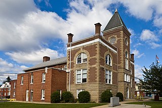
Hinton is a city in and the county seat of Summers County, West Virginia, United States. The population was 2,266 at the 2020 census. Hinton was established in 1873 and chartered in 1897. Hinton was named after John "Jack" Hinton, the original owner of the town site. Much of Hinton's downtown was placed on the National Register of Historic Places in 1984. In 1994, part of Paramount's film Lassie was shot in Hinton. In the 1990s, Hinton's downtown experienced economic decline after a hospital moved away and Interstate 64 bypassed the town. In 2007, Hinton native and business owner Ken Allman founded MountainPlex Properties, which since then has worked to preserve and revitalize the Hinton Historic District.

<span class="mw-page-title-main">Parsons, West Virginia</span> City in West Virginia, United States

Parsons is the largest city in and county seat of Tucker County, West Virginia, United States. The population was 1,322 at the 2020 census. Parsons is located at the confluence of the Shavers Fork and the Black Fork, forming the head of the Cheat River.

<span class="mw-page-title-main">Hundred, West Virginia</span> Town in West Virginia, United States

Hundred is a town in Wetzel County, West Virginia, United States. The population was 257 at the 2020 census. It was named for the fact that local resident Henry "Old Hundred" Church was a centenarian. Hundred is the only place in the United States with this name.

<span class="mw-page-title-main">New Martinsville, West Virginia</span> City in West Virginia, United States

New Martinsville is a city in and the county seat of Wetzel County, West Virginia, United States, along the Ohio River. The population was 5,186 at the 2020 census.

References

  1. "Elected Officials" . Retrieved November 20, 2022.
  2. "2019 U.S. Gazetteer Files". United States Census Bureau. Retrieved August 7, 2020.
  3. 1 2 3 4 "City and Town Population Totals: 2020-2021". Census.gov. US Census Bureau. Retrieved July 3, 2022.
  4. 1 2 "U.S. Census website". United States Census Bureau . Retrieved January 31, 2008.
  5. U.S. Geological Survey Geographic Names Information System: Piedmont, West Virginia
  6. 1 2 Gates, Henry Louis Jr. (1994). Colored People: A Memoir. ISBN   0-679-73919-X.
  7. "US Gazetteer files: 2010, 2000, and 1990". United States Census Bureau. February 12, 2011. Retrieved April 23, 2011.
  8. "US Gazetteer files 2010". United States Census Bureau. Archived from the original on February 20, 2011. Retrieved January 24, 2013.
  9. Kenny, Hamill (1945). West Virginia Place Names: Their Origin and Meaning, Including the Nomenclature of the Streams and Mountains. Piedmont, WV: The Place Name Press. p. 486.
  10. 1 2 Canfield, Jack. "Mineral County". e-WV. West Virginia Humanities Council. Retrieved June 26, 2017.
  11. Times-News, For the Cumberland. "Piedmont's Steve Whiteman of Kix works as music teacher". The Cumberland Times-News. Retrieved October 23, 2017.
  12. "Census of Population and Housing". Census.gov. Retrieved June 4, 2015.
  13. "U.S. Census website". United States Census Bureau . Retrieved January 24, 2013.
  14. Piedmont, West Virginia High Schools. Piedmont Back Street Community Festival Committee. 2017.
  15. Climate Summary for Piedmont, West Virginia