Jefferson County, West Virginia

Last updated

Jefferson County
2016-09-27 12 32 38 The Jefferson County Court House at the intersection of West Virginia State Route 115 (George Street) and West Virginia State Route 51 (Washington Street) in Charles Town, Jefferson County, West Virginia.jpg
Jefferson County, WV Seal.png
Map of West Virginia highlighting Jefferson County.svg
Location within the U.S. state of West Virginia
West Virginia in United States.svg
West Virginia's location within the U.S.
Coordinates: 39°19′N77°52′W / 39.31°N 77.86°W / 39.31; -77.86
CountryFlag of the United States.svg United States
StateFlag of West Virginia.svg  West Virginia
FoundedOctober 26, 1801
Named for Thomas Jefferson
Seat Charles Town
Largest cityCharles Town
Area
  Total212 sq mi (550 km2)
  Land210 sq mi (500 km2)
  Water2.0 sq mi (5 km2)  1.0%
Population
 (2020)
  Total57,701
  Estimate 
(2021)
58,370 Increase2.svg
  Density270/sq mi (110/km2)
Time zone UTC−5 (Eastern)
  Summer (DST) UTC−4 (EDT)
Congressional district 2nd
Website jeffersoncountywv.org

Jefferson County is located in the Shenandoah Valley in the Eastern Panhandle of West Virginia. It is the easternmost county of the U.S. state of West Virginia. As of the 2020 census, the population was 57,701. [1] Its county seat is Charles Town. [2] The county was founded in 1801, and today is part of the Washington metropolitan area. [3]

Contents

History

Formation

Jefferson County was established on October 26, 1801 from Berkeley County because the citizens of southeastern Berkeley County felt they had to travel too far to the county seat of Martinsburg. Charles Washington, the founder of Charles Town and brother to George Washington, petitioned for a new county to be formed. It was named for Thomas Jefferson, author of the Declaration of Independence and third President of the United States. [4] Virginia previously had a Jefferson County, which is now part of Kentucky. Accordingly, in the State records of Virginia, there are listings for Jefferson County from 1780 to 1792 and Jefferson County from 1801 to 1863, neither of which are still in Virginia.

John Brown rebellion

Coverage of John Brown's raid in Frank Leslie's illustrated newspaper, v. 8, no. 205 (November 5, 1859), p. 359 John brown interior engine house.jpg
Coverage of John Brown's raid in Frank Leslie's illustrated newspaper, v. 8, no. 205 (November 5, 1859), p. 359

The county's courthouse was the site of the trial for the abolitionist John Brown after his October 1859 raid on the federal armory in Harpers Ferry. Some 90 U.S. Marines serving under then Army Colonel Robert E. Lee and Lieutenants J.E.B. Stuart and Israel Greene put down the rebellion.

Brown was sentenced to death for murder, treason against the Commonwealth of Virginia, and conspiring with slaves to rebel. On December 2, 1859, John Brown was taken from the Charles Town jail a short distance to an open field and hanged. Among those attending the Brown execution was a contingent of 1500 cadets from Virginia Military Institute sent by the Governor of Virginia Henry A. Wise under the supervision of Major William Gilham and Major Thomas J. Jackson. In the ranks of a Richmond militia company stood John Wilkes Booth. Walt Whitman was also present.

Civil War

The county was a frequent site of conflict during the Civil War, as Union and Confederate lines moved back and forth along the Shenandoah Valley. Some towns in the county changed hands between the Union and Confederacy over a dozen times, including Charles Town, and especially Harpers Ferry.

Jefferson County is the only part of modern-day West Virginia not exempted from the effects of the Emancipation Proclamation (as Berkeley County and the 48 counties designated as West Virginia had been). Slaves in the county thus were legally free as of January 1, 1863.

The Jefferson County Courthouse is the only courthouse in America to have held two treason trials: the trial of John Brown in 1859 and a trial arising from the Battle of Blair Mountain labor rebellion. [5]

Joining West Virginia

Tripoint of Virginia, West Virginia, and Maryland in the Potomac River region of Harper's Ferry, the lowest point in West Virginia MD-VA-WV tripoint in Potomac River.jpg
Tripoint of Virginia, West Virginia, and Maryland in the Potomac River region of Harper's Ferry, the lowest point in West Virginia

Jefferson County had voted for secession in the vote taken on May 23, 1861. However, Jefferson County, along with Berkeley County, both counties lying on the Potomac River in the Shenandoah Valley, with the consent of the Reorganized Government of Virginia voted in favor of annexation to West Virginia in 1863.[ citation needed ] Virginia tried to nullify this after the American Civil War, but the counties remained part of West Virginia.

The question of the constitutionality of the formation of the new state was brought before the Supreme Court of the United States in the following manner: Berkeley and Jefferson County, West Virginia, counties lying on the Potomac east of the mountains, in 1863, with the consent of the Reorganized Government of Virginia, had supposedly voted in favor of annexation to West Virginia. However, many voters were absent in the Confederate Army when the vote was taken and they refused to accept the transfer upon their return. The Virginia General Assembly repealed the Act of Secession and in 1866 brought suit against West Virginia, asking the Supreme Court to declare the counties still part of Virginia. Congress, on March 10, 1866, passed a joint resolution recognizing the transfer. In 1871, the U.S. Supreme Court decided Virginia v. West Virginia , [6] upholding the "secession" of West Virginia, including Berkeley and Jefferson counties, from Virginia. [7] In 2011, West Virginia state delegate Larry Kump sponsored legislation to allow Morgan, Berkeley, and Jefferson counties to rejoin Virginia by popular vote. [8]

County subdivisions

In 1863, West Virginia's counties were divided into civil townships, with the intention of encouraging local government. This proved impractical in the heavily rural state, and in 1872 the townships were converted into magisterial districts. [9] Jefferson County was initially divided into five townships, which became magisterial districts in 1872: Averill, Bolivar, Chapline, Grant, and Shepherd. In 1873, Averill District was renamed "Middleway", Chapline became "Potomac", and Grant District became "Charlestown". [lower-roman 1] Two additional districts, Harpers Ferry [lower-roman 2] and Osburn, were created during the 1870s. In the 1880s, Bolivar District was annexed by Harpers Ferry; Potomac and Shepherd were consolidated into Shepherdstown District, and Osburn was renamed "Kabletown". [10]

Rural Free Delivery

In October 1896, Jefferson County became the first county in the United States to begin Rural Free Delivery service in the towns of Halltown and Uvilla. [11]

Geography

Frederick.svg
Jefferson

According to the U.S. Census Bureau, the county has a total area of 212 square miles (550 km2), of which 210 square miles (540 km2) is land and 2.0 square miles (5.2 km2) (1.0%) is water. [12] It is the only West Virginia county where the Blue Ridge Mountains and Shenandoah River can be found, as referenced in West Virginia's state song, "Take Me Home, Country Roads" by John Denver. The lowest point in the state of West Virginia is located on the Potomac River (just east of Harpers Ferry) in Jefferson County, where it flows out of West Virginia and into Virginia.

National protected area

Rivers and streams

Adjacent counties

Major highways

US 340 and WV Route 9 run concurrently for a few miles in Charles Town 2019-08-17 13 01 48 View south along U.S. Route 340 & east along West Virginia Route 9 (Charles Town Bypass) from the overpass for U.S. Route 340 & West Virginia Route 51 (Washington Street-William L. Wilson Freeway) in Charles Town, West Virginia.jpg
US 340 and WV Route 9 run concurrently for a few miles in Charles Town

Demographics

Historical population
CensusPop.Note
1810 11,851
1820 13,08710.4%
1830 12,927−1.2%
1840 14,0828.9%
1850 15,3579.1%
1860 14,535−5.4%
1870 13,219−9.1%
1880 15,00513.5%
1890 15,5533.7%
1900 15,9352.5%
1910 15,889−0.3%
1920 15,729−1.0%
1930 15,7800.3%
1940 16,7626.2%
1950 17,1842.5%
1960 18,6658.6%
1970 21,28014.0%
1980 30,30242.4%
1990 35,92618.6%
2000 42,19017.4%
2010 53,49826.8%
2020 57,7017.9%
2021 (est.)58,370 [13] 1.2%
U.S. Decennial Census [14]
1790–1960 [15] 1900–1990 [16]
1990–2000 [17] 2010–2020 [1]

2020 census

As of the 2020 census, there were 57,701 people and 21,162 households residing in the county. There were 23,762 housing units in Jefferson county. The racial makeup of the county was 81.2% White, 6% African American, 1.5% Asian, 0.2% Native American, 2.9% from other races, and 8.2% from two or more races. Hispanics or Latinos of any race were 7.2% of the population.

Of the 50,841 households, 53.6% were married couples living together, 21.7% had a female householder with no spouse present, 17.1% had a male householder with no spouse present. The average household and family size was 3.15. The median age in the county was 41 years with 22.1% of the population under 18. The median income for a household was $86,711 and the poverty rate was 9.7%. [18]

2010 census

As of the 2010 U.S. census, there were 53,498 people, 19,931 households, and 13,971 families residing in the county. [19] The population density was 255.2 inhabitants per square mile (98.5/km2). There were 22,037 housing units at an average density of 105.1 per square mile (40.6/km2). [20] The racial makeup of the county was 87.6% white, 6.6% black or African American, 1.2% Asian, 0.2% American Indian, 0.1% Pacific islander, 1.8% from other races, and 2.6% from two or more races. Those of Hispanic or Latino origin made up 4.7% of the population. [19] In terms of ancestry, 25.9% were German, 17.3% were English, 12.1% were Irish, and 6.6% were American. [21]

Of the 19,931 households, 34.6% had children under the age of 18 living with them, 54.9% were married couples living together, 10.1% had a female householder with no husband present, 29.9% were non-families, and 22.7% of all households were made up of individuals. The average household size was 2.61 and the average family size was 3.07. The median age was 38.9 years. [19]

The median income for a household in the county was $65,603 and the median income for a family was $77,185. Males had a median income of $54,959 versus $36,782 for females. The per capita income for the county was $29,733. About 4.4% of families and 8.4% of the population were below the poverty line, including 10.9% of those under age 18 and 6.9% of those age 65 or over. [22]

Government

Law enforcement

The Jefferson County Sheriff's Department provides law enforcement services in the county, and handles all 911 emergency and non emergency calls. In February 2007, Jefferson County Sheriff's Department Corporal Ronald Fletcher was shot and critically wounded during a stand-off at the residence of the girlfriend of a suspect, Dorsey Cox. Cox had been at his girlfriend's house retrieving personal items in violation of a court-ordered protective order. As Corporal Fletcher approached the house, Cox fled inside and subsequently shot Corporal Fletcher four times, one of which struck the officer in the chest. The State Police's SWAT team entered the house. Cox was later found dead of an apparent self-inflicted gunshot wound. [23]

On June 5, 2012, Sheriff Robert Shirley was indicted on one count of deprivation of rights under color of law and one count of destruction, falsification or alteration of a record in a federal investigation. He is alleged to have beaten Mark Daniel Haines, who later pleaded guilty to bank robbery, during his arrest on December 27, 2010. He is also alleged to have altered a use of force report while the incident was under investigation by the Federal Bureau of Investigation. Shirley and 14 other "John Doe" law enforcement officers were also the subject of a civil rights lawsuit filed by Haines. [24] The lawsuit alleges that Shirley and the other officers used excessive force while arresting Haines. Shirley pled guilty to federal civil rights charges of and was sentenced to a year in prison. [25]

Politics

Jefferson County has been a Republican-leaning county in the 21st century, although Barack Obama carried it in the 2008 presidential election. For much of the 20th century, the county trended strongly Democratic due to historical sympathies for Confederate Virginia. In contrast to its rock-ribbed Unionist and Republican Eastern Panhandle sister Morgan County, Jefferson did not vote Republican until Dwight D. Eisenhower won by 27 votes in 1956, and afterwards voted Republican only in the 1972 and 1984 landslides, and in 1988. Despite their strong support for Republican presidential candidates in recent years, local Democrats still have success in Jefferson County. Even as recently as 2018, Senator Joe Manchin won the county in his successful reelection, despite the county being the home of his opponent, Patrick Morrisey.

United States presidential election results for Jefferson County, West Virginia [26]
Year Republican Democratic Third party
No.%No.%No.%
2020 15,03354.26%12,12743.77%5451.97%
2016 13,20453.88%9,51838.84%1,7867.29%
2012 11,25850.63%10,39846.76%5802.61%
2008 10,60046.78%11,68751.58%3721.64%
2004 10,53952.71%9,30146.52%1530.77%
2000 7,04549.00%6,86047.71%4733.29%
1996 5,28740.46%6,36148.68%1,42010.87%
1992 4,65638.21%5,36344.01%2,16617.78%
1988 5,34955.00%4,33444.56%430.44%
1984 5,88458.06%4,21641.60%340.34%
1980 4,45445.37%4,67947.66%6856.98%
1976 3,86442.79%5,16657.21%00.00%
1972 4,82263.41%2,78236.59%00.00%
1968 2,71839.23%3,12945.16%1,08215.62%
1964 1,90127.98%4,89272.02%00.00%
1960 2,88739.88%4,35260.12%00.00%
1956 3,38050.20%3,35349.80%00.00%
1952 3,13443.71%4,03656.29%00.00%
1948 2,19936.60%3,79763.19%130.22%
1944 2,10335.83%3,76764.17%00.00%
1940 2,33230.57%5,29769.43%00.00%
1936 2,04027.20%5,44372.56%180.24%
1932 1,73424.36%5,35075.15%350.49%
1928 3,05047.78%3,31251.88%220.34%
1924 1,87029.07%4,36867.90%1953.03%
1920 2,16835.27%3,94464.16%350.57%
1916 1,18131.33%2,54467.50%441.17%
1912 99326.66%2,52567.79%2075.56%

Communities

Cities

Towns

Magisterial districts

Census-designated places

Unincorporated communities

Historic buildings and structures

See also

Footnotes

  1. Spelled "Charles Town" by 1900.
  2. Originally spelled "Harper's Ferry".

Related Research Articles

<span class="mw-page-title-main">Frederick County, Virginia</span> County in Virginia, United States

Frederick County is located in the Commonwealth of Virginia. As of the 2020 census, the population was 91,419. Its county seat is Winchester. The county was formed in 1743 by the splitting of Orange County. It is Virginia's northernmost county. Frederick County is included in the Winchester, VA-WV Metropolitan Statistical Area, which is also included in the Washington-Baltimore-Northern Virginia, DC-MD-VA-WV-PA Combined Statistical Area.

<span class="mw-page-title-main">Washington County, Maryland</span> County in Maryland, United States

Washington County is located in the western part of the U.S. state of Maryland. As of the 2020 census, the population was 154,705. It is the most populous county in the Western Maryland region and its county seat is Hagerstown.

<span class="mw-page-title-main">Harpers Ferry, West Virginia</span> Town in West Virginia, United States

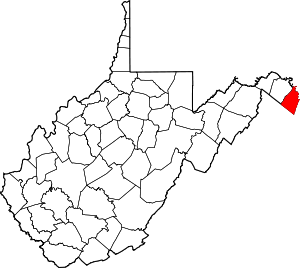
Harpers Ferry is a historic town in Jefferson County, West Virginia, United States, in the lower Shenandoah Valley. The population was 285 at the 2020 census. Situated at the confluence of the Potomac and Shenandoah rivers, where the U.S. states of Maryland, Virginia, and West Virginia meet, it is the easternmost town in West Virginia.

<span class="mw-page-title-main">Nicholas County, West Virginia</span> County in West Virginia, United States

Nicholas County is a county located in the central region of U.S. state of West Virginia. As of the 2020 census, the population was 24,604. Its county seat is Summersville. The county was created in 1818 by the Virginia General Assembly and named for Virginia Governor Wilson Cary Nicholas.

<span class="mw-page-title-main">Morgan County, West Virginia</span> County in West Virginia, United States

Morgan County is a county located in the U.S. state of West Virginia. As of the 2020 census, the population was 17,063. Its county seat is Berkeley Springs. The county was formed in 1820 from parts of Hampshire and Berkeley Counties and named in honor of General Daniel Morgan, prominent soldier of the American Revolutionary War. The county and town of Bath are considered an excellent jumping off point for exploring the Potomac and Cacapon Rivers valleys just to the north and west. Along with also being a tourist destination hosting numerous local artists, mineral water spas, and a large amount of outdoor recreation that includes fishing, boating, wildlife, hunting, and mountain scenery. The region is known for the famed Apple Butter Festival held annually in October. Morgan County is also the home of an important silica mine, part of U.S. Silica.

<span class="mw-page-title-main">Hardy County, West Virginia</span> County in West Virginia, United States

Hardy County is a county in the U.S. state of West Virginia. As of the 2020 census, the population was 14,299. Its county seat is Moorefield. The county was created from Hampshire County in 1786 and named for Samuel Hardy, a distinguished Virginian.

<span class="mw-page-title-main">Berkeley County, West Virginia</span> County in West Virginia, United States

Berkeley County is located in the Shenandoah Valley in the eastern panhandle region of West Virginia in the United States. The county is part of the Hagerstown–Martinsburg metropolitan area. As of the 2020 census, the county population was 122,076, making it the second-most populous of West Virginia's 55 counties, behind Kanawha County. The City of Martinsburg is the county seat.

<span class="mw-page-title-main">Ashtabula County, Ohio</span> County in Ohio, United States

Ashtabula County is the northeasternmost county in the U.S. state of Ohio. As of the 2020 census, the population was 97,574. The county seat is Jefferson, while its largest city is Ashtabula. The county was created in 1808 and later organized in 1811. The name Ashtabula derives from the Lenape language phrase ashte-pihële, which translates to 'always enough (fish) to go around, to be given away' and is a contraction of apchi ('always') + tepi ('enough') + hële. Ashtabula County is part of the Cleveland, OH Metropolitan Statistical Area.

<span class="mw-page-title-main">Romney, West Virginia</span> Town in West Virginia, United States

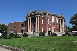
Romney is a town in and the county seat of Hampshire County, West Virginia, United States. The population was 1,722 at the 2020 census. It is part of the Winchester, Virginia metropolitan area. The town was established in 1762 along with Shepherdstown; together, they are the two oldest towns in West Virginia.

<span class="mw-page-title-main">Bolivar, West Virginia</span> Town in West Virginia, United States

Bolivar is a town in Jefferson County, West Virginia, United States. The population was 1,072 at the 2020 census. The town is named for South American revolutionary leader Simón Bolívar. Located in West Virginia's Eastern Panhandle, it is part of the northwestern fringes of the Washington metropolitan area.

<span class="mw-page-title-main">Charles Town, West Virginia</span> City in West Virginia, United States

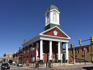
Charles Town is a city in and the county seat of Jefferson County, West Virginia, United States. The population was 6,534 at the 2020 census. The city is named for its founder Charles Washington, youngest brother of President George Washington. It is part of the northwestern fringes of the Washington metropolitan area.

<span class="mw-page-title-main">Shepherdstown, West Virginia</span> Town in West Virginia, United States

Shepherdstown is a town in Jefferson County, West Virginia, United States, located in the lower Shenandoah Valley along the Potomac River. Home to Shepherd University, the town's population was 1,531 at the time of the 2020 census. The town was established in 1762 along with Romney; they are the oldest towns in West Virginia.

<span class="mw-page-title-main">Berkeley Springs, West Virginia</span> Town in West Virginia, United States

Berkeley Springs is a town in, and the county seat of, Morgan County, West Virginia, United States, in the state's Eastern Panhandle. Berkeley Springs is also commonly used to refer to the area in and around the Town of Bath. In 1776, the Virginia Legislature incorporated a town around the springs and named it Bath. Since 1802, it has been referred to by the name of its original post office, Berkeley Springs. The population was 758 at the 2020 census. It is part of the Hagerstown–Martinsburg metropolitan area.

<span class="mw-page-title-main">Paw Paw, West Virginia</span> Town in West Virginia, United States

Paw Paw is a town in Morgan County, West Virginia, United States. The population was 410 at the 2020 census. The town is known for the nearby Paw Paw Tunnel. Paw Paw was incorporated by the Circuit Court of Morgan County on April 8, 1891, and named after pawpaw, a wild fruit that grows in abundance throughout this region. Paw Paw is the westernmost incorporated community in Morgan County, and the Hagerstown-Martinsburg, MD-WV Metropolitan Statistical Area.

<span class="mw-page-title-main">Eastern panhandle of West Virginia</span> Place

The eastern panhandle is one of the two panhandles in the U.S. state of West Virginia; the other is the northern panhandle. It is a small stretch of territory in the northeast of the state, bordering Maryland and Virginia. Some sources and regional associations only identify the eastern panhandle as being composed of Morgan, Berkeley, and Jefferson counties. Berkeley and Jefferson counties are geographically located in the Shenandoah Valley. West Virginia is the only U.S. state with two panhandles.

<span class="mw-page-title-main">Harpers Ferry National Historical Park</span> Park at confluence of Virginia, West Virginia and Maryland in the United States

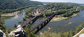
Harpers Ferry National Historical Park, originally Harpers Ferry National Monument, is located at the confluence of the Potomac and Shenandoah rivers in and around Harpers Ferry, West Virginia. The park includes the historic center of Harpers Ferry, notable as a key 19th-century industrial area and as the scene of John Brown's failed abolitionist uprising. It contains the most visited historic site in the state of West Virginia, John Brown's Fort.

<span class="mw-page-title-main">Andrew Hunter (lawyer)</span> American lawyer (1804–1888)

Andrew H. Hunter was a Virginia lawyer, slaveholder, and politician who served in both houses of the Virginia General Assembly, including the Confederate House of Delegates. He was the Commonwealth's attorney for Jefferson County, Virginia, who prosecuted John Brown for the raid on Harpers Ferry.

<span class="mw-page-title-main">William Lucas (Virginia politician)</span> American politician

William Lucas was a nineteenth-century planter, politician and lawyer from Virginia.

<span class="mw-page-title-main">Harpers Ferry Armory</span> Former United States federal armory

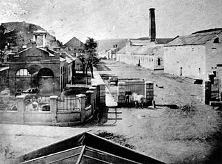
The Harpers Ferry Armory, more formally known as the United States Armory and Arsenal at Harpers Ferry, was the second federal armory created by the United States government; the first was the Springfield Armory. It was located in Harpers Ferry, Virginia, which since 1863 has been part of West Virginia. It was both an arsenal, manufacturing firearms, and an armory, a storehouse for firearms. Along with the Springfield Armory, it was instrumental in the development of machining techniques to make interchangeable parts of precisely the same dimensions.

References

  1. 1 2 "State & County QuickFacts". United States Census Bureau. Retrieved March 25, 2022.
  2. "Find a County". National Association of Counties. Archived from the original on May 31, 2011. Retrieved June 7, 2011.
  3. "Jefferson County history sources". Archived from the original on May 30, 2013. Retrieved January 29, 2013.
  4. Gannett, Henry (1905). The Origin of Certain Place Names in the United States. Govt. Print. Off. pp.  168.
  5. McGee, Ted (March 7, 1973). "National Register of Historic Places Nomination: Jefferson County Courthouse" (PDF). National Park Service. Archived (PDF) from the original on June 4, 2011.{{cite journal}}: Cite journal requires |journal= (help)
  6. Virginia v. West Virginia , 78U.S.39 (1871).
  7. "东京一本一道一二三区_高清在线不卡一区二区". www.newsgroups-index.com. Archived from the original on December 1, 2008.
  8. Vincent, Jenni (January 25, 2011). "Secession bill planned to 'stir pot'". The Journal . Archived from the original on February 11, 2015. Retrieved July 27, 2013.
  9. Otis K. Rice & Stephen W. Brown, West Virginia: A History, 2nd ed., University Press of Kentucky, Lexington (1993), p. 240.
  10. United States Census Bureau, U.S. Decennial Census, Tables of Minor Civil Divisions in West Virginia, 1870–2010.
  11. "First Rural Routes by State". United States Postal Service. Archived from the original on December 28, 2013. Retrieved December 28, 2013.
  12. "2010 Census Gazetteer Files". United States Census Bureau. August 22, 2012. Archived from the original on September 4, 2015. Retrieved July 24, 2015.
  13. "Annual Estimates of the Resident Population for Counties: April 1, 2020 to July 1, 2021" . Retrieved August 14, 2022.
  14. "U.S. Decennial Census". United States Census Bureau. Retrieved January 10, 2014.
  15. "Historical Census Browser". University of Virginia Library. Archived from the original on August 11, 2012. Retrieved January 10, 2014.
  16. "Population of Counties by Decennial Census: 1900 to 1990". United States Census Bureau. Archived from the original on June 3, 2013. Retrieved January 10, 2014.
  17. "Census 2000 PHC-T-4. Ranking Tables for Counties: 1990 and 2000" (PDF). United States Census Bureau. Archived (PDF) from the original on December 18, 2014. Retrieved January 10, 2014.
  18. "Explore Census Data". data.census.gov. Retrieved March 31, 2023.
  19. 1 2 3 "DP-1 Profile of General Population and Housing Characteristics: 2010 Demographic Profile Data". United States Census Bureau. Archived from the original on February 13, 2020. Retrieved April 3, 2016.
  20. "Population, Housing Units, Area, and Density: 2010 – County". United States Census Bureau. Archived from the original on February 13, 2020. Retrieved April 3, 2016.
  21. "DP02 SELECTED SOCIAL CHARACTERISTICS IN THE UNITED STATES – 2006–2010 American Community Survey 5-Year Estimates". United States Census Bureau. Archived from the original on February 13, 2020. Retrieved April 3, 2016.
  22. "DP03 SELECTED ECONOMIC CHARACTERISTICS – 2006–2010 American Community Survey 5-Year Estimates". United States Census Bureau. Archived from the original on February 13, 2020. Retrieved April 3, 2016.
  23. "Herald-Mail Media: Local News, Politics & Sports in Hagerstown, MD". Archived from the original on February 10, 2012. Retrieved December 19, 2021.
  24. "Shirley named in beating lawsuit | Spirit of Jefferson". Archived from the original on February 2, 2013. Retrieved June 8, 2012.
  25. Vicki Smith (May 13, 2013). "Ex-Jefferson County sheriff sentenced to 1 year in federal prison in beating of robbery suspect". The Hagerstown Herald-Mail. Retrieved December 19, 2021.
  26. Leip, David. "Dave Leip's Atlas of U.S. Presidential Elections". uselectionatlas.org. Archived from the original on March 23, 2018. Retrieved March 23, 2018.
  27. "Landmarks Nomination Report: New Hopewell" (PDF). Jefferson County Historic Landmark Commission. Archived from the original (PDF) on October 11, 2011. Retrieved March 20, 2012.

Further reading

39°19′N77°52′W / 39.31°N 77.86°W / 39.31; -77.86