Manassas Park, Virginia | |
---|---|
City of Manassas Park | |
Coordinates: 38°46′19″N77°27′09″W / 38.77194°N 77.45250°W | |
Country | United States |
State | Virginia |
Pre-incorporation County | Prince William County (None after Incorporation - Independent city) |
Incorporated | 1975 |
Named for | Manassas, Virginia |
Government | |
• Mayor | Jeanette Rishell |
Area | |
• Total | 3.03 sq mi (7.86 km2) |
• Land | 3.03 sq mi (7.86 km2) |
• Water | 0.00 sq mi (0.00 km2) |
Population (2020) | |
• Total | 17,219 |
• Density | 5,682.84/sq mi (2,194.16/km2) |
Time zone | UTC-5 |
• Summer (DST) | UTC-4 |
Zip Code | 20111 |
FIPS code | 51-48968 [2] |
GNIS feature ID | 1495894 [3] |
Website | City of Manassas Park |
Manassas Park is an independent city in the U.S. state of Virginia. As of the 2020 census, the population was 17,219. [4] Manassas Park is bordered by the city of Manassas and Prince William County. Manassas Park is a part of the Washington-Arlington-Alexandria, DC-VA-MD-WV Metropolitan Statistical Area.
During the American Civil War, the Manassas Park area was used as a campsite by the Confederate States Army during both the First and Second Battles of Bull Run.
Manassas Park was created as a subdivision of Prince William County, with the first houses being constructed in 1955. In 1957, Manassas Park was incorporated as a town. Approximately 600 acres of land was annexed by the town of Manassas Park in 1974, and the town was incorporated as a city independent from the county the next year in 1975. Since then, it has been Virginia's newest city. [5]
Manassas Park is located at 38°46′19″N77°27′09″W / 38.77194°N 77.45250°W (38.771944, -77.45250). It is roughly dumbbell-shaped and lies to the south of Bull Run. It is longest NW–SE along Manassas Drive, and is bisected by Virginia State Route 28 at its narrowest section.
According to the United States Census Bureau, the city has a total area of 2.5 square miles (6.5 km2), all of it land. [6]
Census | Pop. | Note | %± |
---|---|---|---|
1960 | 5,342 | — | |
1970 | 6,844 | 28.1% | |
1980 | 6,524 | −4.7% | |
1990 | 6,734 | 3.2% | |
2000 | 10,290 | 52.8% | |
2010 | 14,273 | 38.7% | |
2020 | 17,219 | 20.6% | |
U.S. Decennial Census [7] 1790-1960 [8] 1900-1990 [9] 1990-2000 [10] 2020-2020 [11] |
Year | Republican | Democratic | Third party | |||
---|---|---|---|---|---|---|
No. | % | No. | % | No. | % | |
2020 | 1,979 | 32.51% | 3,992 | 65.58% | 116 | 1.91% |
2016 | 1,733 | 33.12% | 3,204 | 61.24% | 295 | 5.64% |
2012 | 1,699 | 36.49% | 2,879 | 61.83% | 78 | 1.68% |
2008 | 1,634 | 39.47% | 2,463 | 59.49% | 43 | 1.04% |
2004 | 1,807 | 54.23% | 1,498 | 44.96% | 27 | 0.81% |
2000 | 1,460 | 56.59% | 1,048 | 40.62% | 72 | 2.79% |
1996 | 916 | 49.84% | 748 | 40.70% | 174 | 9.47% |
1992 | 792 | 46.05% | 567 | 32.97% | 361 | 20.99% |
1988 | 993 | 68.67% | 434 | 30.01% | 19 | 1.31% |
1984 | 975 | 71.96% | 375 | 27.68% | 5 | 0.37% |
1980 | 729 | 58.13% | 447 | 35.65% | 78 | 6.22% |
1976 | 444 | 37.34% | 709 | 59.63% | 36 | 3.03% |
Race / Ethnicity | Pop 2010 [13] | Pop 2020 [11] | % 2010 | % 2020 |
---|---|---|---|---|
White alone (NH) | 6,070 | 4,706 | 42.53% | 27.33% |
Black or African American alone (NH) | 1,784 | 2,076 | 12.50% | 12.06% |
Native American or Alaska Native alone (NH) | 31 | 27 | 0.22% | 0.16% |
Asian alone (NH) | 1,261 | 1,827 | 8.83% | 10.61% |
Pacific Islander alone (NH) | 17 | 13 | 0.12% | 0.08% |
Some Other Race alone (NH) | 48 | 133 | 0.34% | 0.77% |
Mixed Race/Multi-Racial (NH) | 417 | 638 | 2.92% | 3.71% |
Hispanic or Latino (any race) | 4,645 | 7,799 | 32.54% | 45.29% |
Total | 14,273 | 17,219 | 100.00% | 100.00% |
At the 2000 census there were 10,290 people, 3,254 households and 2,557 families in the city. The population density was 4,129.0 inhabitants per square mile (1,594.2/km2). There were 3,365 housing units at an average density of 1,350.3 per square mile (521.4/km2). The racial makeup of the city was 72.79% White, 11.17% African American, 0.44% Native American, 4.06% Asian, 0.07% Pacific Islander, 8.14% from other races, and 3.33% from two or more races. Hispanic or Latino of any race were 15.00%. [14]
Of the 3,254 households 45.4% had children under the age of 18 living with them, 59.9% were married couples living together, 12.1% had a female householder with no husband present, and 21.4% were non-families. 14.4% of households were one person and 2.6% were one person aged 65 or older. The average household size was 3.16 and the average family size was 3.47.
The age distribution was 31.0% under the age of 18, 8.7% from 18 to 24, 40.1% from 25 to 44, 15.9% from 45 to 64, and 4.3% 65 or older. The median age was 30 years. For every 100 females, there were 103.8 males. For every 100 females age 18 and over, there were 103.0 males.
The median household income was $60,794 and the median family income was $61,075. Males had a median income of $38,643 versus $30,942 for females. The per capita income for the city was $21,048. About 4.7% of families and 5.2% of the population were below the poverty line, including 5.8% of those under age 18 and 11.2% of those age 65 or over.
In June 2021, U.S. News & World Report ranked Manassas Park with the fifth best life expectancy in the United States at 92.5 years old. [15]
The city is served by Manassas Park City Schools, with a total of 4 schools: Cougar Elementary, Manassas Park Elementary, Manassas Park Middle, and Manassas Park High School. There are also Private Schools.
Virginia State Route 28 is the main highway serving the city. From Manassas Park, SR 28 extends north to Interstate 66 and south to Virginia State Route 234, providing connections to major cities through the region.
Virginia State Route 213 follows Manassas Drive, serving as a main roadway within Manassas Park. However, the route designation is unsigned.
The city is home to Manassas Park station located on the Manassas Line of the Virginia Railway Express.
Covington County, is a county located in the south central portion of the U.S. state of Alabama. As of the 2020 census the population was 37,570. Its county seat is Andalusia. Its name is in honor of Brigadier General Leonard Covington of Maryland and Mississippi, who died in the War of 1812.
Spotsylvania County is a county in the U.S. state of Virginia. As of the July 2021 estimate, the population was 143,676. Its county seat is Spotsylvania Courthouse.
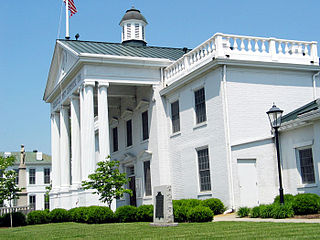
Richmond County is a county located on the Northern Neck in the U.S. state of Virginia. As of the 2020 census, the population sits at 8,923. Its county seat is Warsaw. The rural county should not be confused with the large city and state capital Richmond, Virginia. It was formed in 1692 when the first Rappahannock County was divided to form Richmond County and Essex County.
Madison County is a county located in the Commonwealth of Virginia. As of the 2020 census, the population was 13,837. Its county seat is Madison.
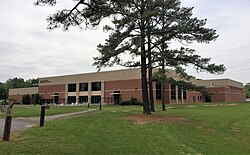
Greensville County is a county located in the Commonwealth of Virginia. As of the 2020 census, the population was 11,391. Its county seat is Emporia.
Emporia is an independent city in the Commonwealth of Virginia, surrounded by Greensville County, United States. Emporia and a predecessor town have been the county seat of Greensville County since 1791. As of the 2020 census, the population was 5,766, making it the third-least populous city in Virginia. The Bureau of Economic Analysis combines the city of Emporia with surrounding Greensville County for statistical purposes.
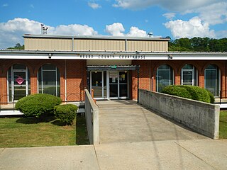
Heard County is a county located in the west central portion of the U.S. state of Georgia. At the 2020 census, the population was 11,412, down from 11,834 in 2010. The county seat is Franklin. The county was created on December 22, 1830.
Bartow is a town in Jefferson County, Georgia, United States. As of the 2020 census, the city had a population of 186. Initially the town was known as "Spier's Turnout", but was changed to honor the first Confederate officer to die in battle, Colonel Francis S. Bartow of Savannah, Georgia, who was killed at the Battle of Manassas, Virginia on July 21, 1861.
Manassas is a city in Tattnall County, Georgia, United States. Per the 2020 census, the population was 59.
Poplar Hills is a home rule-class city in Jefferson County, Kentucky, United States. It is a part of the Louisville Metro government, but operates as a city under the Mayor to Commissioner form of government. Per the 2020 census, the population was 380, but the city administration has made several annexation ordinances that have passed and awaits updated information. The current city population is estimated to be 2380. It currently has the highest population density for any city in Kentucky.
Woodlawn is an unincorporated community and census-designated place in Baltimore County, Maryland. Per the 2020 census, the population was 39,986. It is home to the headquarters of the Social Security Administration (SSA) and the Centers for Medicare and Medicaid Services (CMS). It is bordered by Catonsville on the south, by the Patapsco River and Howard County on the west, by Randallstown and Lochearn to the north, and by the City of Baltimore to the east. Parts of Woodlawn are sometimes informally referred to as Security, Maryland, due to the importance of the SSA's headquarters as well as nearby Security Boulevard and Security Square Mall.
Chester is a census-designated place (CDP) in Chesterfield County, Virginia, United States. Per the 2020 census, the population was 23,414.
Idylwood is a census-designated place (CDP) in Fairfax County, Virginia, United States. The population was 17,954 as of the 2020 census. It originally developed as a suburban community along the route of the Washington and Old Dominion Railroad, and later along Virginia State Route 7. The construction of the Capital Beltway in the 1960s, and I-66 and the Orange Line of the Washington Metrorail system in the 1980s, as well as the concurrent development of nearby Tysons Corner into Washington's leading suburban business district, led to the development of several apartment, townhouse, and small-lot single-family housing complexes, as well as the high-rise Idylwood Towers condominium, in the portion of Idylwood lying to the north of I-66. The area to the south of I-66 remains primarily large-lot single-family.
East Highland Park is a census-designated place (CDP) in Henrico County, Virginia, in the United States. The population was 15,131 at the 2020 census.
Highland Springs is a census-designated place (CDP) located in Henrico County, Virginia, United States, 4.3 miles (7 km) east of Richmond. The population was 16,604 at the 2020 census.
Woodbridge is a census-designated place (CDP) in Prince William County, Virginia, United States, located 20 miles (32 km) south of Washington, D.C. Bounded by the Occoquan and Potomac rivers, Woodbridge had 44,668 residents at the 2020 census.
Yorkshire is a census-designated place (CDP) in Prince William County, Virginia, United States. It is an annex of Manassas, Virginia. The population was 6,732 at the 2000 census.
Petersburg is a city in Grant County, West Virginia, United States. The population was 2,251 at the 2020 census. It is the county seat of Grant County.
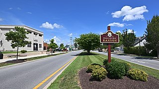
Ranson is a city in Jefferson County, West Virginia, United States. The population was 5,433 at the 2020 census. It is part of the northwestern fringes of the Washington metropolitan area.
{{cite web}}
: CS1 maint: url-status (link)