Pendleton County is a county located in the U.S. state of West Virginia. As of the 2020 census, the population was 6,143, making it the second-least populous county in West Virginia. Its county seat is Franklin. The county was created by the Virginia General Assembly in 1788 from parts of Augusta, Hardy, and Rockingham counties and was named for Edmund Pendleton (1721–1803), a distinguished Virginia statesman and jurist. Pendleton County was strongly pro-Confederate during the American Civil War; however, there were pockets of Unionists who supported the state government in Wheeling.

The Natural Bridge Caverns are the largest commercial caverns in the US state of Texas. The name is derived from the 60-foot (18 m) natural limestone slab bridge that spans the amphitheater setting of the cavern's entrance. The span was left suspended when a sinkhole collapsed below it.

Luray Caverns, previously Luray Cave, is a cave just west of Luray, Virginia, United States, which has drawn many visitors since its discovery in 1878. The cavern system is adorned with speleothems such as columns, mud flows, stalactites, stalagmites, flowstone, and mirrored pools. The caverns host the Great Stalacpipe Organ, a lithophone made from solenoid-fired strikers that tap stalactites of varied sizes to produce tones similar to those of xylophones, tuning forks, or bells.
Cathedral Caverns State Park is a public recreation area and natural history preserve located in Kennamer Cove, Alabama, approximately 5 miles (8.0 km) northeast of Grant and 7 miles (11 km) southeast of Woodville in Marshall County. The park, first known as Bats Cave, was developed as a tourist attraction in the 1950s. Cathedral Caverns was declared a National Natural Landmark in 1972 and opened as a state park in 2000.

Laurel Caverns is the largest cave in the Commonwealth of Pennsylvania by volume and area. Located in the community of Farmington, it sits on the Chestnut Ridge near Uniontown, roughly 50 miles (80 km) southeast of Pittsburgh.

Bluespring Caverns is a cave system located in Lawrence County, Indiana, approximately 80 miles (128 km) south of Indianapolis. The cave system is a karst and river type cave formation and drains a 15 miles² (38.8 km²) sinkhole plain. The cave contains 21 miles (34 km) of surveyed passages and is most notable for having the longest known subterranean river in the United States with approximately 3 miles (4.8 km) of navigable river.
Mystic Caverns and Crystal Dome are show caves located between the cities of Jasper and Harrison, in the state of Arkansas, U.S., on the Arkansas Highway 7 Scenic Byway near the defunct amusement park Dogpatch USA. Sometimes called "the twin caves" because they are within 400 feet (120 m) of each other, the two caves maintain a year-round temperature of 58 °F, contain more formations per foot than any other caves in Arkansas, and are open for public tours year-round except during the January flooding season.
The Potomac Highlands of West Virginia centers on five West Virginian counties in the upper Potomac River watershed in the western portion of the state's Eastern Panhandle, bordering Maryland and Virginia. Because of geographical proximity, similar topography and landscapes, and shared culture and history, the Potomac Highlands region also includes Pocahontas, Randolph, and Tucker counties, even though they are in the Monongahela River or New River watersheds and not that of the Potomac River.

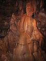
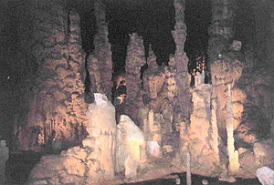
Smoke Hole Caverns (SHC) is a picturesque show cave in Grant County in West Virginia's Eastern Panhandle.

Thor's Cave is a natural cavern located at SK09865496 in the Manifold Valley of the White Peak in Staffordshire, England. It is classified as a karst cave. Located in a steep limestone crag, the cave entrance, a symmetrical arch 7.5 metres wide and 10 metres high, is prominently visible from the valley bottom, around 80 metres (260 feet) below. Reached by an easy stepped path from the Manifold Way, the cave is a popular tourist spot, with views over the Manifold Valley. The second entrance is known as the "West Window", below which is a second cave, Thor's Fissure Cavern.

Sea Lion Caves is a connected system of sea caves and caverns open to the Pacific Ocean in the U.S. state of Oregon. They are located 11 miles (18 km) north of Florence on U.S. Highway 101, about midpoint on the 400 miles (640 km) of Oregon Coast. In this area, Highway 101 follows a steep and undeveloped seascape 300 feet (91 m) above sea level. Human access to the caves is through a gift shop building.

Moaning Caverns is a solutional cave located in the Calaveras County, California, near Vallecito, California in the heart of the state's Gold Country. It is developed in marble of the Calaveras Formation. It was discovered in modern times by gold miners in 1851, but it has long been known as an interesting geological feature by prehistoric peoples. It gets its name from the moaning sound that echoed out of the cave luring people to the entrance, however expansion of the opening to allow access for the public disrupted the sounds. The portion of the cave developed for tourists consists of a spacious vertical shaft 165 feet tall, which is descended by a combination of stairs and a unique 100-foot-high (30 m) spiral staircase built in the early 1900s. It is open to the public for walking tours and spelunking. Including the off-trail areas, the cave reaches a depth of 410 feet.
Titan is a natural cavern near Castleton in the Derbyshire Peak District, and is the deepest shaft of any known cave in Britain, at 141.5 metres (464 ft). The existence of Titan was revealed in November 2006, following its discovery on 1 January 1999 after cavers discovered connections from the James Hall Over Engine Mine to both Speedwell Cavern and Peak Cavern. Previously, the deepest known underground shaft in Britain had been Gaping Gill on the slopes of Ingleborough in the Yorkshire Dales.

Lost River Cave is a seven-mile cave system located in Bowling Green, Kentucky. The Lost River originates outside of the cave and flows into it. The cave contains one of the largest natural entrances in the Eastern U.S. Boat tours are available year-round, but closed for Thanksgiving Day, Christmas Eve, Christmas Day, and New Year's Day. The river was once listed by Ripley's Believe it or Not as the "Shortest, deepest river in the world" because the blue hole is over 437 feet deep, while the river itself is only 400 feet long. In fact, the blue hole is only 16 feet deep, but is linked to a further underground river. The 72-acre cave property is jointly owned by Western Kentucky University and the non-profit Friends of Lost River Cave.

Indian Caverns was a show cave in Spruce Creek, Pennsylvania, United States from 1929-2017. It is a horizontal karst cave of Ordovician Nealmont/Benner limestone, estimated to be about 500,000 years old. It is the second-largest cave in Pennsylvania and the largest limestone cave. Indian Caverns consists of two sections, originally separated by a 14-foot wall: the "Historic Cave" and the "Giant's Hall". The "historic" part of the cave is generally low-ceilinged and closer to the surface with a couple of wide rooms and extensive speleothem formation. The Giant's Hall area consists of several large passageways, up to 60 feet high, but with fewer speleothems - though it does include the largest sheet of flowstone in the northeast and a substantial rimstone pool. The lowest point of the cave is approximately 140 feet beneath the surface and the cave temperature is a constant 56 degrees Fahrenheit.

The Sinks of Gandy — also called the Sinks of Gandy Creek, or simply "The Sinks" — are a modestly celebrated cave and underground stream at Osceola in eastern Randolph County, West Virginia, United States. The Sinks are on private property within the Monongahela National Forest.

Onondaga Cave State Park is a Missouri state park located on the Meramec River approximately 5 miles (8.0 km) southeast of the village of Leasburg. The park was established in 1982. Park activities include cave tours, camping, fishing, hiking, picnicking, and swimming.

Germany Valley is a scenic upland valley high in the Allegheny Mountains of eastern West Virginia originally settled by German farmers in the mid-18th century. It is today a part of the Spruce Knob–Seneca Rocks National Recreation Area of the Monongahela National Forest, although much ownership of the Valley remains in private hands.

Stump Cross Caverns is a limestone cave system between Wharfedale and Nidderdale in North Yorkshire, England.

Cascade Caverns is a historically, geologically, and biologically important limestone solutional cave 3 mi (4.8 km) south of Boerne, Texas, United States, on 226 Cascade Caverns Road, in Kendall County. It has been commercially operated as a show cave and open for public tours since 1932. Informal tours were run as far back as 1875, when Dr. Benjamin Hester owned the cave property. The cave was known by the native Lipan Apache people who lived in the area prior to 1800.