New Martinsville, West Virginia

Last updated

New Martinsville, West Virginia
Newmartinsvillewv.jpg
View from Keidaisch Point on the Ohio side of the river
Seal of New Martinsville, West Virginia.png
Logo of New Martinsville, West Virginia.png
Wetzel County West Virginia Incorporated and Unincorporated areas New Martinsville Highlighted.svg
Location of New Martinsville in Wetzel County, West Virginia.
Coordinates: 39°39′27″N80°51′34″W / 39.65750°N 80.85944°W / 39.65750; -80.85944
Country United States
State West Virginia
County Wetzel
Government
  Type Mayor–council
Area
[1]
  Total2.71 sq mi (7.02 km2)
  Land2.67 sq mi (6.92 km2)
  Water0.04 sq mi (0.10 km2)
Elevation
623 ft (190 m)
Population
 (2010) [2]
  Total5,186
  Estimate 
(2021) [2]
5,174
  Density1,914.70/sq mi (739.36/km2)
Time zone UTC-5 (Eastern (EST))
  Summer (DST) UTC-4 (EDT)
ZIP code
26155
Area code 304
FIPS code 54-58684 [3]
GNIS feature ID1544131 [4]
Website cityofnewmartinsvillewv.com

New Martinsville is a city in and the county seat of Wetzel County, West Virginia, United States, along the Ohio River. [5] The population was 5,186 at the 2020 census. [2]

Contents

History

Wetzel County Courthouse in New Martinsville, October 2006 2006-10-05 10-41-03newmartinsvillecourthouse.JPG
Wetzel County Courthouse in New Martinsville, October 2006

The town was named after Presley Martin, an early settler. [6]

Geography

New Martinsville is located at 39°39′27″N80°51′34″W / 39.65750°N 80.85944°W / 39.65750; -80.85944 (39.657465, -80.859504). [7] Doolin Run and Fishing Creek are located downstream nearby, just south of town. [8] [9]

According to the United States Census Bureau, the city has a total area of 2.71 square miles (7.02 km2), of which 2.67 square miles (6.92 km2) is land and 0.04 square miles (0.10 km2) is water. [10]

Climate

The climate in this area is characterized by relatively high temperatures and evenly distributed precipitation throughout the year. According to the Köppen Climate Classification system, New Martinsville has a Humid subtropical climate, abbreviated "Cfa" on climate maps. [11]

Demographics

Historical population
CensusPop.Note
1850 228
1870 260
1880 778199.2%
1890 692−11.1%
1900 1,08957.4%
1910 2,17699.8%
1920 2,3417.6%
1930 2,81420.2%
1940 3,49124.1%
1950 4,08417.0%
1960 5,60737.3%
1970 6,52816.4%
1980 7,1098.9%
1990 6,705−5.7%
2000 5,984−10.8%
2010 5,366−10.3%
2020 5,186−3.4%
2021 (est.)5,174 [2] −0.2%
U.S. Decennial Census [12]

2010 census

As of the census [13] of 2010, there were 5,366 people, 2,340 households, and 1,477 families living in the city. The population density was 2,009.7 inhabitants per square mile (775.9/km2). There were 2,632 housing units at an average density of 985.8 per square mile (380.6/km2). The racial makeup of the city was 98.2% White, 0.2% African American, 0.1% Native American, 0.6% Asian, 0.3% from other races, and 0.6% from two or more races. Hispanic or Latino of any race were 0.6% of the population.

There were 2,340 households, of which 25.7% had children under the age of 18 living with them, 46.8% were married couples living together, 12.1% had a female householder with no husband present, 4.2% had a male householder with no wife present, and 36.9% were non-families. 32.2% of all households were made up of individuals, and 15.1% had someone living alone who was 65 years of age or older. The average household size was 2.24 and the average family size was 2.78.

The median age in the city was 46.5 years. 20.5% of residents were under the age of 18; 6.1% were between the ages of 18 and 24; 20.9% were from 25 to 44; 30.6% were from 45 to 64; and 21.7% were 65 years of age or older. The gender makeup of the city was 47.2% male and 52.8% female.

2000 census

As of the census [3] of 2000, there were 5,984 people, 2,484 households, and 1,684 families living in the city. The population density was 2,157.4 people per square mile (834.1/km2). There were 2,737 housing units at an average density of 986.8 per square mile (381.5/km2). The racial makeup of the city was 98.55% White, 0.05% African American, 0.10% Native American, 0.75% Asian, 0.03% Pacific Islander, 0.02% from other races, and 0.50% from two or more races. Hispanic or Latino of any race were 0.43% of the population.

There were 2,484 households, out of which 28.9% had children under the age of 18 living with them, 52.6% were married couples living together, 11.7% had a female householder with no husband present, and 32.2% were non-families. 28.9% of all households were made up of individuals, and 13.4% had someone living alone who was 65 years of age or older. The average household size was 2.34 and the average family size was 2.86.

In the city, the population was spread out, with 22.9% under the age of 18, 6.7% from 18 to 24, 25.4% from 25 to 44, 26.8% from 45 to 64, and 18.2% who were 65 years of age or older. The median age was 42 years. For every 100 females, there were 88.2 males. For every 100 females age 18 and over, there were 81.5 males.

The median income for a household in the city was $33,750, and the median income for a family was $40,851. Males had a median income of $37,614 versus $21,019 for females. The per capita income for the city was $18,578. About 16.9% of families and 20.6% of the population were below the poverty line, including 29.4% of those under age 18 and 15.1% of those age 65 or over.

Government

Mayor: Sandy Hunt
1st Ward Councilman: Jeff Gieseke
2nd Ward Councilman: Joey Smith
3rd Ward Councilman: Ron Brill
4th Ward Councilman: Steve Pallisco
5th Ward Councilman: Joel Potts
6th Ward Councilman: Iris (Deaner) Isaacs

Notable people

See also

Related Research Articles

<span class="mw-page-title-main">Wetzel County, West Virginia</span> County in West Virginia, United States

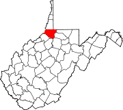
Wetzel County is a county in the U.S. state of West Virginia. As of the 2020 census, the population was 14,442. Its county seat is New Martinsville. The county, founded in 1846, is named for Lewis Wetzel, a famous frontiersman and Indian fighter. Its northern border aligns with the Mason-Dixon line, but is to the west of the line's western terminus.

<span class="mw-page-title-main">Martinsville, Illinois</span> City in Illinois, United States

Martinsville is a city in Clark County, Illinois, United States. The population was 1,118 at the 2020 census.

<span class="mw-page-title-main">Clarington, Ohio</span> Village in Ohio, United States

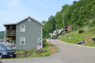
Clarington is a village in Monroe County, Ohio, United States, along the Ohio River. The population was 280 at the 2020 census.

<span class="mw-page-title-main">Bassett, Virginia</span> CDP in Virginia, United States

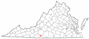
Bassett is a census-designated place (CDP) in Henry County, Virginia, United States. The population was 1,100 at the 2010 census. It is part of the Martinsville Micropolitan Statistical Area. The town was founded along a rail line by the same family that later started Bassett Furniture. Bassett Furniture's headquarters have remained in Bassett since it began in 1902.

<span class="mw-page-title-main">Collinsville, Virginia</span> CDP in Virginia, United States

Collinsville is a census-designated place (CDP) in Henry County, Virginia, United States. The population was 7,335 at the 2010 census, which was down from the 7,777 reported in 2000. It is part of the Martinsville Micropolitan Statistical Area. Collinsville is also where the administration building and county courthouse of Henry County are located.

<span class="mw-page-title-main">Ridgeway, Virginia</span> Town in Virginia, United States

Ridgeway is a town in Henry County, Virginia, United States. The population was 742 at the 2010 census. It is part of the Martinsville Micropolitan Statistical Area. Martinsville Speedway, a NASCAR racetrack, is located between Ridgeway and the Martinsville city limits.

<span class="mw-page-title-main">Burnsville, West Virginia</span> Town in West Virginia, United States

Burnsville is a town in Braxton County, West Virginia, United States, at the confluence of the Little Kanawha River and Saltlick Creek. The population was 401 at the 2020 census. Burnsville was incorporated in 1902 by the Circuit Court and named for Captain John Burns who operated the first sawmill in that section of the state and who established the town shortly after the close of the American Civil War. It was named "All West Virginia City" in 1976.

<span class="mw-page-title-main">Grantsville, West Virginia</span> Town in West Virginia, United States

Grantsville is a town in Calhoun County, West Virginia, United States. The population was 482 at the 2020 census. It is the county seat of Calhoun County. The town was established along the Little Kanawha River in 1865 and named for Ulysses S. Grant. Grantsville is home to Wayne Underwood Park, which includes a .25-mile-long (0.40 km) walking trail, and to the annual West Virginia Wood Festival.

<span class="mw-page-title-main">Man, West Virginia</span> Town in West Virginia, United States

Man is a town in Logan County, West Virginia, United States. The population was 772 at the 2020 census. The town is located along the Guyandotte River at the mouth of Buffalo Creek, which was the site of the 1972 Buffalo Creek Flood following a dam collapse. The name of the town reportedly derives from the last syllable of the surname of Ulysses Hinchman, who was a member of the House of Delegates from Logan County between 1866 and 1869.

<span class="mw-page-title-main">McMechen, West Virginia</span> City in West Virginia

McMechen is a city in Marshall County, West Virginia, United States, situated along the Ohio River. It is part of the Wheeling, West Virginia Metropolitan Statistical Area. The population was 1,714 at the 2020 census.

<span class="mw-page-title-main">Henderson, West Virginia</span> Unincorporated Town in West Virginia, United States

Henderson is an unincorporated community and former town in Mason County, West Virginia, United States, at the confluence of the Ohio and Kanawha Rivers. The population was 231 at the 2020 census. It is part of the Point Pleasant, WV–OH Micropolitan Statistical Area. The town was incorporated in 1893 and named for Samuel Bruce Henderson, who owned the townsite at the time. The town was unincorporated following a public hearing on August 11, 2022.

<span class="mw-page-title-main">Albright, West Virginia</span> Town in West Virginia, United States

Albright is a town in central Preston County, West Virginia, United States, along the Cheat River. The population was 260 at the 2020 census. A former coal town, it is part of the Morgantown metropolitan area.

<span class="mw-page-title-main">Bruceton Mills, West Virginia</span> Town in West Virginia, United States

Bruceton Mills is a town in northern Preston County, West Virginia, United States, along Big Sandy Creek. The population was 64 at the 2020 census, making it the second-least populous town in West Virginia, after Thurmond. It is part of the Morgantown metropolitan area.

<span class="mw-page-title-main">Cairo, West Virginia</span> Town in West Virginia, United States

Cairo is a town in Ritchie County, West Virginia, United States, along West Virginia Route 31, the North Fork of the Hughes River, and the North Bend Rail Trail. The population was 174 at the 2020 census.

<span class="mw-page-title-main">Hambleton, West Virginia</span> Town in West Virginia, United States

Hambleton is a town in Tucker County, West Virginia, United States. The population was 216 at the 2020 census. Hambleton was established in 1889, but not incorporated until 1905. It was named by then United States Senator Stephen B. Elkins in honor of a stockholder by this name in the West Virginia Central Railroad Company. The town was previously known as Hulings.

<span class="mw-page-title-main">Pine Grove, West Virginia</span> Town in West Virginia, United States

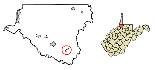
Pine Grove is a town in Wetzel County, West Virginia, United States. The population was 363 at the 2020 census. The community was named for a grove of pine trees near the original town site.

<span class="mw-page-title-main">Smithfield, West Virginia</span> Town in West Virginia, United States

Smithfield is a town in Wetzel County, West Virginia, United States. The population was 103 at the 2020 census.

<span class="mw-page-title-main">Oceana, West Virginia</span> Town in West Virginia, United States

Oceana is a town in Wyoming County, West Virginia. The population was 1,462 at the time of the 2020 census. Oceana is the oldest city in Wyoming County and was the county seat until 1907.

<span class="mw-page-title-main">Baggs, Wyoming</span> Town in Wyoming, United States

Baggs is a town in Carbon County, Wyoming, United States. The population was 411 at the 2020 census. Baggs is home to the Outlaw Stop, a branch of the Little Snake River Museum, which is headquartered in Savery.

<span class="mw-page-title-main">Paden City, West Virginia</span> City in West Virginia, United States

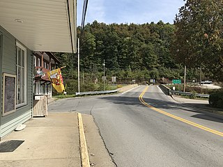
Paden City is a city in Tyler and Wetzel counties in the U.S. state of West Virginia, along the Ohio River. It was founded in 1902. The population was 2,550 at the 2020 census.

References

  1. "2019 U.S. Gazetteer Files". United States Census Bureau. Retrieved August 7, 2020.
  2. 1 2 3 4 "City and Town Population Totals: 2020-2021". Census.gov. US Census Bureau. Retrieved July 2, 2022.
  3. 1 2 "U.S. Census website". United States Census Bureau . Retrieved January 31, 2008.
  4. "US Board on Geographic Names". United States Geological Survey. October 25, 2007. Retrieved January 31, 2008.
  5. "Find a County". National Association of Counties. Retrieved June 7, 2011.
  6. Kenny, Hamill (1945). West Virginia Place Names: Their Origin and Meaning, Including the Nomenclature of the Streams and Mountains. Piedmont, WV: The Place Name Press. p. 443.
  7. "US Gazetteer files: 2010, 2000, and 1990". United States Census Bureau. February 12, 2011. Retrieved April 23, 2011.
  8. TOPOZONE: Fishing Creek Topo Map in Wetzel County WV; accessed October 2018.
  9. Hometown Locator: Zip Code 26155, accessed October 2018.
  10. "US Gazetteer files 2010". United States Census Bureau. Archived from the original on January 12, 2012. Retrieved January 24, 2013.
  11. Climate Summary for New Martinsville, West Virginia
  12. "Census of Population and Housing". Census.gov. Retrieved June 4, 2015.
  13. "U.S. Census website". United States Census Bureau . Retrieved January 24, 2013.