Nottinghamshire County Council

Last updated

Nottinghamshire County Council
Arms of Nottinghamshire County Council.svg
Nottinghamshire County Council logo.svg
Type
Type
Leadership
Richard Butler,
Conservative
since 16 May 2024 [1]
Ben Bradley,
Conservative
since 27 May 2021
Adrian Smith
since September 2022
Structure
Seats66 councillors
Composition of Nottinghamshire County Council since Dec 2023.svg
Political groups
Administration (35)
  Conservatives (35)
Other parties (31)
  Labour (15)
  Ashfield Ind. (10)
  Independent (6)
Length of term
4 years
Elections
First past the post
Last election
6 May 2021
Next election
1 May 2025
Meeting place
County Hall, West Bridgford - geograph.org.uk - 985420.jpg
County Hall, Loughborough Road, West Bridgford, Nottingham, NG2 7QP
Website
www.nottinghamshire.gov.uk

Nottinghamshire County Council is the upper-tier local authority for the non-metropolitan county of Nottinghamshire in England. It consists of 66 county councillors, elected from 56 electoral divisions every four years. The most recent election was held in 2021.

Contents

The county council is based at County Hall in West Bridgford. The council does not have jurisdiction over Nottingham, which is a unitary authority governed by Nottingham City Council. The council is a constituent member of the East Midlands Combined County Authority.

History

Elected county councils were created in 1889 under the Local Government Act 1888, taking over many administrative functions that had previously been performed by unelected magistrates at the quarter sessions. The borough of Nottingham had been a county corporate since 1449 with its own quarter sessions, and Nottingham's independence from the surrounding county was maintained by making it a county borough. The county council was elected by and provided services to the remainder of the county outside the borough of Nottingham, which area was termed the administrative county. [2]

The first elections to the county council were held on 15 January 1889, with 51 councillors being elected. There were also 17 aldermen chosen by the councillors to serve on the council as well. [3] The council formally came into its powers on 1 April 1889, on which day it held its first official meeting at the Shire Hall in Nottingham. Henry Strutt, Lord Belper, a Liberal Unionist peer, was the first chairman of the council. [4]

The county council was reconstituted in 1974 as a non-metropolitan county by the Local Government Act 1972; the first elections to the reformed council were held in 1973. All urban districts, rural districts and municipal boroughs within the county were abolished and replaced with non-metropolitan districts. Whilst previously the City of Nottingham was an independent county borough and therefore not included within the administrative county of Nottinghamshire or involved in the election of county councillors, the new non-metropolitan county included Nottingham for the first time as a non-metropolitan district. [5]

In 1998, Nottingham regained independent control over its affairs when it became a unitary authority. Since then the county council has had control over the county of Nottinghamshire, excluding the City of Nottingham. [6]

In 2024 a combined county authority was established covering Nottinghamshire, Nottingham, Derby and Derbyshire, called the East Midlands Combined County Authority. The combined authority is chaired by the directly elected Mayor of the East Midlands and oversees the delivery of certain strategic functions across the area. [7]

Governance

Nottinghamshire County Council provides county-level services such as education, transport, social care, libraries, trading standards and waste management. [8] District-level services are provided by the area's seven district councils: [9]

Much of the county is also covered by civil parishes, which form a third tier of local government. [10]

Political control

The council has been under Conservative majority control since 2021.

Political control of the council since the 1974 reforms has been as follows: [11] [12]

Party in controlYears
Labour 1973–1977
Conservative 1977–1981
Labour 1981–2009
Conservative 2009–2013
Labour 2013–2017
No overall control 2017–2021
Conservative 2021–present

Leadership

The leaders of the council since 1974 have been: [13]

CouncillorPartyFromTo
Dick Wilson [14] Labour 1 Apr 19741977
Peter Wright [15] Conservative May 19771980
Herbert Bird Conservative 19801981
Gordon Cragg [16] Conservative 1981May 1981
Dennis Pettitt [17] Labour May 19812001
Mick Warner [18] Labour 20018 May 2005
David Kirkham Labour 19 May 20057 Jun 2009
Kay Cutts Conservative 18 Jun 200916 May 2013
Alan Rhodes Labour 16 May 201325 May 2017
Kay Cutts Conservative 25 May 20179 May 2021
Ben Bradley Conservative 27 May 2021

Composition

Following the 2021 election and subsequent by-elections and changes of allegiance up to December 2023, the composition of the council was: [19]

PartyCouncillors
Conservative 35
Labour 15
Ashfield Ind. 10
Independent 6
Total66

The next election is due in 2025.

Premises

The county council is based at County Hall on the south bank of the River Trent in West Bridgford. A replacement headquarters is under construction on the A611 Annesley Road in the parish of Linby, on the northern outskirts of Hucknall, due to open in 2025. [20] [21]

Old Shire Hall, High Pavement, Nottingham: Council's meeting place 1889-1954 Lace market justice galleries.JPG
Old Shire Hall, High Pavement, Nottingham: Council's meeting place 1889–1954

When the county council was first created it met at the Shire Hall on High Pavement in Nottingham, a courthouse built in 1770 which had been the meeting place of the quarter sessions which preceded the county council. [22] The council moved to County Hall in 1954; construction had begun in 1939 but had been paused due to the Second World War. When construction began the site was within the boundaries of Nottingham. [23] Boundary changes in April 1952 adjusted the boundary between Nottingham and West Bridgford in this area to follow the centre of the River Trent, transferring the County Hall site and other areas on the south bank of the Trent from Nottingham to West Bridgford. [24]

Elections

Since the last boundary changes in 2017 the council has comprised 66 councillors representing 56 electoral divisions, with each division electing one or two councillors. Elections are held every four years. [25]

Electoral Divisions

Nottinghamshire is divided into 56 divisions for electoral purposes. Current boundaries have been in place since 2017 following a review by the Local Government Boundary Commission for England. Each Councillor is allocated a locality budget, described as their "Councillors' Divisional Fund". [26]

Map of the electoral divisions of Nottinghamshire. Nottinghamshire Electoral Divisions.png
Map of the electoral divisions of Nottinghamshire.
Map No.Electoral divisionCouncillors
1Arnold North2
2Arnold South2
3Ashfields1
4Balderton1
5Beeston Central & Rylands1
6Bingham East1
7Bingham West1
8Blidworth1
9Blyth & Harworth1
10Bramcote & Beeston North1
11Calverton1
12Carlton East1
13Carlton West2
14Collingham1
15Cotgrave1
16Eastwood1
17Farndon & Trent1
18Greasley & Brinsley1
19Hucknall North1
20Hucknall South1
21Hucknall West1
22Keyworth1
23Kirkby North1
24Kirkby South1
25Leake & Ruddington2
26Mansfield East2
27Mansfield North2
28Mansfield South2
29Mansfield West2
30Misterton1
31Muskham & Farnsfield1
32Newark East1
33Newark West1
34Newstead1
35Nuthall & Kimberley1
36Ollerton1
37Radcliffe on Trent1
38Retford East1
39Retford West1
40Selston1
41Sherwood Forest1
42Southwell1
43Stapleford & Broxtowe Central2
44Sutton Central & East1
45Sutton North1
46Sutton West1
47Toton, Chilwell & Attenborough2
48Tuxford1
49Warsop1
50West Bridgford North1
51West Bridgford South1
52West Bridgford West1
53Worksop East1
54Worksop North1
55Worksop South1
56Worksop West1

Related Research Articles

<span class="mw-page-title-main">Nottinghamshire</span> County of England

Nottinghamshire is a ceremonial county in the East Midlands of England. The county borders South Yorkshire to the north-west, Lincolnshire to the east, Leicestershire to the south, and Derbyshire to the west. The largest settlement is the city of Nottingham (323,632).

<span class="mw-page-title-main">Borough of Melton</span> Borough and non-metropolitan district in England

Melton is a local government district with borough status in north-eastern Leicestershire, England. It is named after its only town, Melton Mowbray. The borough also includes numerous villages and surrounding rural areas. The north of the district includes part of the Vale of Belvoir. Melton is the least populous district of its type and the fourth least populous district in England overall.

<span class="mw-page-title-main">Borough of Erewash</span> Borough in eastern Derbyshire, England

Erewash is a local government district with borough status in Derbyshire, England. The borough is named after the River Erewash. The council has offices in both the borough's towns of Ilkeston and Long Eaton. The borough also includes several villages and surrounding rural areas. Some of the built-up areas in the east of the borough form part of the Nottingham Urban Area.

<span class="mw-page-title-main">Bassetlaw District</span> District of Nottinghamshire, England

Bassetlaw is a local government district in north Nottinghamshire, England. Its council is based in the town of Worksop; the other towns in the district are Retford, Tuxford and Harworth Bircotes. The district also contains numerous villages and surrounding rural areas.

<span class="mw-page-title-main">Borough of Broxtowe</span> Non-metropolitan district and borough in England

Broxtowe is a local government district with borough status in Nottinghamshire, England. It lies immediately west of the city of Nottingham, and most of the built-up areas of the borough form part of the Nottingham Urban Area. The council is based in Beeston and the borough also includes the towns of Eastwood, Kimberley and Stapleford and surrounding villages and rural areas.

<span class="mw-page-title-main">Rushcliffe</span> Non-metropolitan district and borough in England

Rushcliffe is a local government district with borough status in south Nottinghamshire, England. Its council is based in West Bridgford. The borough also includes the towns of Bingham and Cotgrave as well as numerous villages and surrounding rural areas. Some of the built-up areas in the north-west of the borough, including West Bridgford, form part of the Nottingham Urban Area.

<span class="mw-page-title-main">Borough of Gedling</span> Local government district in Nottinghamshire

Gedling is a local government district with borough status in Nottinghamshire, England. The council is based in Arnold. The borough also includes Carlton along with villages and rural areas to the north-east of Nottingham. The main built-up part of the borough around Arnold and Carlton forms part of the Nottingham Urban Area.

<span class="mw-page-title-main">Dudley Metropolitan Borough Council</span>

Dudley Metropolitan Borough Council is the local authority for Dudley metropolitan borough. It is more commonly known as Dudley Council or Dudley MBC.

<span class="mw-page-title-main">Mansfield District</span> Non-metropolitan district in England

Mansfield District is a local government district in Nottinghamshire, England. It is named after the town of Mansfield, where the council is based. The district also contains Mansfield Woodhouse and Warsop.

<span class="mw-page-title-main">Nottingham City Council</span> Non-metropolitan district council for the unitary authority of Nottingham

Nottingham City Council is the local authority for Nottingham, a unitary authority with city status. Nottingham is in the ceremonial county of Nottinghamshire, England, but as a unitary authority the city council is administratively independent from the surrounding Nottinghamshire County Council. The city council consists of 55 councillors, representing a total of 20 wards, elected every four years. The council is led by Neghat Khan, of the majority Labour Party. The council is a constituent member of the East Midlands Combined County Authority.

<span class="mw-page-title-main">Derbyshire County Council</span>

Derbyshire County Council is the upper-tier local authority for the non-metropolitan county of Derbyshire in England. The non-metropolitan county is smaller than the ceremonial county, which additionally includes Derby. The county council is based at County Hall in Matlock. Since 2017 the council has been under Conservative majority control. The council is a constituent member of the East Midlands Combined County Authority.

<span class="mw-page-title-main">City of Bradford Metropolitan District Council</span> Local government body in England

City of Bradford Metropolitan District Council is the local authority of the City of Bradford in West Yorkshire, England. It is a metropolitan district council, one of five in West Yorkshire and one of 36 in the metropolitan counties of England, and provides the majority of local government services in Bradford. Since 2014 it has been a constituent member of the West Yorkshire Combined Authority.

<span class="mw-page-title-main">Derby City Council</span>

Derby City Council is the local authority for Derby, a unitary authority with city status in the East Midlands region of England.

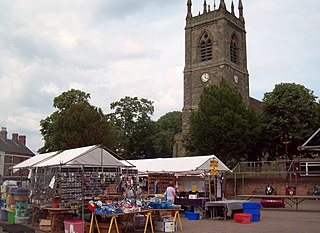
Rushcliffe Borough Council elections are held every four years. Rushcliffe Borough Council is the local authority for the non-metropolitan district of Rushcliffe in Nottinghamshire, England. Since the last boundary changes in 2023 the council has comprised 44 councillors representing 24 wards, with each ward electing one, two or three councillors.

Gedling Borough Council elections are held every four years. Gedling Borough Council is the local authority for the non-metropolitan district of Gedling in Nottinghamshire, England. Since the last boundary changes in 2015, 41 councillors have been elected from 19 wards.

<span class="mw-page-title-main">Wakefield Council</span>

Wakefield Council, formally the City of Wakefield Metropolitan District Council, is the local authority of the City of Wakefield in West Yorkshire, England. Wakefield is a metropolitan borough with city status. The council and provides a full range of local government services including Council Tax billing, libraries, social services, town planning, waste collection and disposal, and it is a local education authority. Wakefield is divided into 21 wards, electing 63 councillors. A third of the council is elected for three of every four years.

<span class="mw-page-title-main">Barnsley Metropolitan Borough Council</span>

Barnsley Metropolitan Borough Council is the local authority of the Metropolitan Borough of Barnsley in South Yorkshire, England. Barnsley is a metropolitan borough, one of four in South Yorkshire, and provides the majority of local government services in Barnsley. The council is a constituent member of the South Yorkshire Mayoral Combined Authority.

<span class="mw-page-title-main">Calderdale Metropolitan Borough Council</span> Local government body in England

Calderdale Metropolitan Borough Council is the local authority for the Metropolitan Borough of Calderdale in West Yorkshire, England. The council styles itself Calderdale Council. It is a metropolitan district council, one of five in West Yorkshire and one of 36 in the metropolitan counties of England. It provides the majority of local government services in Calderdale. Since 2014 the council has been a constituent member of the West Yorkshire Combined Authority.

<span class="mw-page-title-main">South Tyneside Council</span>

South Tyneside Council is the local authority of for the metropolitan borough of South Tyneside in the ceremonial county of Tyne and Wear in North East England. It is one of five metropolitan boroughs in Tyne and Wear and one of 36 in England. It provides the majority of local government services in South Tyneside. The council has been under Labour majority control since 1979. It is based at South Shields Town Hall. The council is a constituent member of the North East Mayoral Combined Authority.

<span class="mw-page-title-main">Borough of Chesterfield</span> Borough and non-metropolitan local government district Derbyshire, England

The Borough of Chesterfield is a non-metropolitan district with borough status in Derbyshire, England. It is named after the town of Chesterfield, its largest settlement, and also contains the town of Staveley and the large village of Brimington.

References

  1. "Cotgrave councillor elected Chairman of Nottinghamshire County Council". West Bridgford Wire. 18 May 2024. Retrieved 21 May 2024.
  2. "Local Government Act 1888", legislation.gov.uk , The National Archives, 1888 c. 41, retrieved 27 August 2023
  3. "History of Nottinghamshire County Council". Nottinghamshire County Council. Retrieved 15 October 2016.
  4. "County Councils: Nottinghamshire". Retford and Gainsborough Times. 5 April 1889. p. 3. Retrieved 18 December 2023.
  5. Local Government Act 1972. 1972 c.70. The Stationery Office Ltd. 1997. ISBN   0-10-547072-4.
  6. "The Nottinghamshire (City of Nottingham) (Structural Change) Order 1996". legislation.gov.uk. Retrieved 15 October 2016.
  7. "The East Midlands Combined County Authority Regulations 2024", legislation.gov.uk , The National Archives, SI 2024/232, retrieved 6 May 2024
  8. "Understand how your council works". www.gov.uk. HM Government . Retrieved 15 October 2016.
  9. "Local Government Act 1972", legislation.gov.uk , The National Archives, 1972 c. 70, retrieved 31 May 2023
  10. "Election Maps". Ordnance Survey. Retrieved 18 November 2023.
  11. "Compositions calculator". The Elections Centre. 4 March 2016. Retrieved 10 August 2022.
  12. "Nottinghamshire". BBC News Online. 19 April 2009. Retrieved 25 September 2009.
  13. "Council minutes". Nottinghamshire County Council. Retrieved 19 August 2022.
  14. Wilson, Judy (5 July 2023). "Dick Wilson obituary". The Guardian. Retrieved 17 December 2023.
  15. "'Dignity' call as Tories step in". Nottingham Evening Post. 18 May 1977. Retrieved 17 December 2023.
  16. "Tories have new leader". Stapleford and Sandiacre News. 14 May 1981. p. 2. Retrieved 17 December 2023.
  17. "Councillor Dennis Pettitt, Leader of the County Council (1981–2001)". Art UK. Retrieved 17 December 2023.
  18. "Twin the money". The Mirror. 4 April 2004. Retrieved 17 December 2023.
  19. "Councillors". Nottinghamshire County Council. Retrieved 18 December 2023.
  20. "County Council to make major savings by moving civic and democratic base from County Hall". Nottinghamshire County Council. 13 July 2023. Retrieved 18 December 2023.
  21. Burrows, Fionn (14 December 2023). "Work begins on Nottinghamshire County Council's new £18.3m, low carbon headquarters office near Hucknall after decision to leave County Hall in West Bridgford, Nottingham". Newark Advertiser. Retrieved 18 December 2023.
  22. Historic England. "Shire Hall and adjoining county gaol, High Pavement, Nottingham (1254517)". National Heritage List for England . Retrieved 13 August 2019.
  23. "1:25,000 Administrative Area Series, 1946". National Library of Scotland. Ordnance Survey. Retrieved 1 July 2023.
  24. "Nottingham City and County Boundaries Act 1951 (14 & 15 Geo 6 c. 31)". legislation.gov.uk. The National Archives. Retrieved 1 July 2023.
  25. "The Nottinghamshire (Electoral Changes) Order 2016", legislation.gov.uk , The National Archives, SI 2016/659, retrieved 18 December 2023
  26. "Councillors' divisional fund". Nottinghamshire County Council. Nottinghamshire County Council. Retrieved 4 March 2022.