Oakley, Idaho

Last updated

Oakley, Idaho
Cassia County Idaho Incorporated and Unincorporated areas Oakley Highlighted 1658330.svg
Location of Oakley in Cassia County, Idaho.
Usa edcp location map.svg
Red pog.svg
Oakley, Idaho
Location in the United States
Coordinates: 42°14′32″N113°52′51″W / 42.24222°N 113.88083°W / 42.24222; -113.88083
Country United States
State Idaho
County Cassia
Oakley Village1878 [1]
Government
  MayorLarry Mickelsen [2]
Area
[3]
  Total4.63 sq mi (11.98 km2)
  Land4.62 sq mi (11.97 km2)
  Water0.00 sq mi (0.00 km2)
Elevation
4,570 ft (1,390 m)
Population
 (2010) [4]
  Total763
  Estimate 
(2019) [5]
812
  Density175.64/sq mi (67.82/km2)
Time zone UTC-7 (Mountain (MST))
  Summer (DST) UTC-6 (MDT)
ZIP code
83346
Area code 208
FIPS code 16-58330
GNIS feature ID0396977
Websiteoakleyidaho.org

Oakley is a city in Cassia County, Idaho, United States. The population was 763 at the 2010 census, up from 668 in 2000. [6] It is part of the Burley Micropolitan Statistical Area.

History

The city was named for William Oakley, the proprietor of a 19th-century stagecoach station located at a spring currently located about 2 miles (3.2 km) west of the present townsite known as Oakley Meadows.

Oakley Academy was established in 1901 [7] , and Howells Opera House was established in 1907. [8] [9]

Geography

Oakley is located at the very southern limit of the Snake River Plain, and close to Goose Creek, between the Middle and Albion Mountains.

According to the United States Census Bureau, the city has a total area of 4.59 square miles (11.89 km2), all of it land. [10]

Climate

According to the Köppen Climate Classification system, Oakley has a cold semi-arid climate, abbreviated "BSk" on climate maps. The hottest temperature recorded in Oakley was 108 °F (42.2 °C) on July 2122, 1893, while the coldest temperature recorded was −27 °F (−32.8 °C) on February 9, 1933. [11]

Climate data for Oakley, Idaho, 1991–2020 normals, extremes 1893–present
MonthJanFebMarAprMayJunJulAugSepOctNovDecYear
Record high °F (°C)64
(18)
70
(21)
77
(25)
90
(32)
98
(37)
104
(40)
108
(42)
107
(42)
101
(38)
91
(33)
77
(25)
73
(23)
108
(42)
Mean maximum °F (°C)52.1
(11.2)
57.4
(14.1)
69.1
(20.6)
76.9
(24.9)
83.4
(28.6)
90.7
(32.6)
96.1
(35.6)
94.2
(34.6)
89.2
(31.8)
79.5
(26.4)
66.1
(18.9)
54.1
(12.3)
96.7
(35.9)
Mean daily maximum °F (°C)39.9
(4.4)
44.5
(6.9)
54.0
(12.2)
60.3
(15.7)
68.8
(20.4)
77.6
(25.3)
86.4
(30.2)
85.6
(29.8)
76.8
(24.9)
63.9
(17.7)
49.5
(9.7)
39.0
(3.9)
62.2
(16.8)
Daily mean °F (°C)30.6
(−0.8)
34.3
(1.3)
41.8
(5.4)
47.2
(8.4)
55.1
(12.8)
63.0
(17.2)
71.5
(21.9)
70.5
(21.4)
61.9
(16.6)
50.5
(10.3)
38.6
(3.7)
30.1
(−1.1)
49.6
(9.8)
Mean daily minimum °F (°C)21.4
(−5.9)
24.2
(−4.3)
29.6
(−1.3)
34.0
(1.1)
41.5
(5.3)
48.4
(9.1)
56.6
(13.7)
55.5
(13.1)
47.1
(8.4)
37.1
(2.8)
27.7
(−2.4)
21.1
(−6.1)
37.0
(2.8)
Mean minimum °F (°C)1.7
(−16.8)
7.2
(−13.8)
14.8
(−9.6)
21.1
(−6.1)
28.4
(−2.0)
35.8
(2.1)
46.1
(7.8)
44.0
(6.7)
33.1
(0.6)
20.9
(−6.2)
9.5
(−12.5)
2.7
(−16.3)
−3.7
(−19.8)
Record low °F (°C)−25
(−32)
−27
(−33)
−2
(−19)
2
(−17)
17
(−8)
24
(−4)
31
(−1)
30
(−1)
17
(−8)
7
(−14)
−14
(−26)
−26
(−32)
−27
(−33)
Average precipitation inches (mm)0.82
(21)
0.69
(18)
1.14
(29)
1.55
(39)
2.05
(52)
1.12
(28)
0.69
(18)
0.72
(18)
1.08
(27)
0.88
(22)
0.78
(20)
0.79
(20)
12.31
(312)
Average snowfall inches (cm)5.7
(14)
5.0
(13)
4.2
(11)
2.0
(5.1)
0.2
(0.51)
0.0
(0.0)
0.0
(0.0)
0.0
(0.0)
0.0
(0.0)
0.6
(1.5)
2.2
(5.6)
5.2
(13)
25.1
(63.71)
Average precipitation days (≥ 0.01 in)6.65.87.48.29.76.13.94.03.65.35.76.072.3
Average snowy days (≥ 0.1 in)3.32.31.70.70.10.00.00.00.00.21.42.912.6
Source 1: NOAA [12]
Source 2: National Weather Service [11]

Demographics

Historical population
CensusPop.Note
1910 911
1920 1,27339.7%
1930 882−30.7%
1940 813−7.8%
1950 684−15.9%
1960 613−10.4%
1970 6567.0%
1980 6631.1%
1990 635−4.2%
2000 6685.2%
2010 76314.2%
2020 7863.0%
U.S. Decennial Census [13]

2010 census

As of the census [4] of 2010, there were 763 people, 248 households, and 192 families residing in the city. The population density was 166.2 inhabitants per square mile (64.2/km2). There were 280 housing units at an average density of 61.0 per square mile (23.6/km2). The racial makeup of the city was 92.5% White, 0.1% Native American, 0.3% Asian, 6.6% from other races, and 0.5% from two or more races. Hispanic or Latino of any race were 9.4% of the population.

There were 248 households, of which 37.9% had children under the age of 18 living with them, 67.3% were married couples living together, 8.5% had a female householder with no husband present, 1.6% had a male householder with no wife present, and 22.6% were non-families. 21.4% of all households were made up of individuals, and 11.3% had someone living alone who was 65 years of age or older. The average household size was 3.08 and the average family size was 3.60.

The median age in the city was 34.6 years. 35.8% of residents were under the age of 18; 5% were between the ages of 18 and 24; 22.1% were from 25 to 44; 20.8% were from 45 to 64; and 16.4% were 65 years of age or older. The gender makeup of the city was 49.9% male and 50.1% female.

2000 census

As of the census [14] of 2000, there were 668 people, 226 households, and 166 families residing in the city. The population density was 167.4 inhabitants per square mile (64.6/km2). There were 257 housing units at an average density of 64.4 per square mile (24.9/km2). The racial makeup of the city was 96.41% White, 0.15% Asian, 3.14% from other races, and 0.30% from two or more races. Hispanic or Latino of any race were 4.19% of the population.

There were 226 households, out of which 39.8% had children under the age of 18 living with them, 62.4% were married couples living together, 7.5% had a female householder with no husband present, and 26.5% were non-families. 26.1% of all households were made up of individuals, and 16.8% had someone living alone who was 65 years of age or older. The average household size was 2.93 and the average family size was 3.60.

In the city, the population was spread out, with 33.8% under the age of 18, 7.6% from 18 to 24, 20.5% from 25 to 44, 21.9% from 45 to 64, and 16.2% who were 65 years of age or older. The median age was 36 years. For every 100 females, there were 95.9 males. For every 100 females age 18 and over, there were 93.0 males.

The median income for a household in the city was $29,643, and the median income for a family was $34,792. Males had a median income of $27,083 versus $16,667 for females. The per capita income for the city was $13,983. About 9.1% of families and 14.7% of the population were below the poverty line, including 27.2% of those under age 18 and 4.8% of those age 65 or over.

Economy

Oakley Stone is a type of building stone quarried south of Oakley.

Arts and culture

Victorian house in Oakley Historic District OAKLEY HISTORIC DISTRICT, CASSIA COUNTY, IDAHO.jpg
Victorian house in Oakley Historic District

Oakley Pioneer Days is an annual even celebrating "the settling of the west". [15] [16] The event has included a rodeo, a pony express race, food vendors, and sporting events. [15]

Oakley is notable for its historic Victorian homes. [17]

The Oakley Historic District is listed on the National Register of Historic Places. The entire town is listed due to the number of stone and brick buildings that are over a century old. [18]

Oakley Valley Historical Museum chronicles the history of Oakley and the surrounding area. [19]

The Oakley Free Library was established in 1973. [20]

Education

Oakley is in the Cassia County School District. Schools located in Oakley include Oakley Elementary School and Oakley Junior/Senior High School. [21]

Notable people

See also


Related Research Articles

<span class="mw-page-title-main">Inkom, Idaho</span> City in Idaho, United States

Inkom is a city in Bannock County, Idaho. It is part of the Pocatello, Idaho Metropolitan Statistical Area. The population was 854 at the time of the 2010 census. It is the home of the smallest airport in the world, Simko Field Airport 1ID9, with a runway length of 122 meters.

<span class="mw-page-title-main">Dover, Idaho</span> City in Idaho, United States

Dover is a city in Bonner County, Idaho. The population was 556 at the 2010 census.

<span class="mw-page-title-main">Hope, Idaho</span> City in Idaho, United States

Hope is a city in Bonner County, Idaho, United States. The population was 86 at the 2010 census.

<span class="mw-page-title-main">Priest River, Idaho</span> City in Idaho, United States

Priest River is a city in Bonner County, Idaho. The population was 1,696 at the 2020 census, and 1,751 at the 2010 census. Located in the Idaho Panhandle region of the state, the city is at the mouth of the Priest River on the Pend Oreille River.

<span class="mw-page-title-main">Irwin, Idaho</span> City in Idaho, United States

Irwin is a city in Bonneville County, Idaho, United States. It is part of the Idaho Falls, Idaho Metropolitan Statistical Area. The population was 259 at the 2020 census, and 219 at the 2010 census.

<span class="mw-page-title-main">Moyie Springs, Idaho</span> City in Idaho, United States

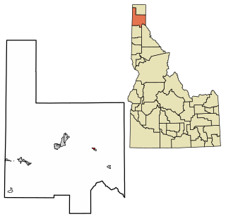
Moyie Springs is a city in Boundary County, Idaho, United States. The population was 718 at the 2010 census.

<span class="mw-page-title-main">Bancroft, Idaho</span> City in Caribou County, Idaho, United States

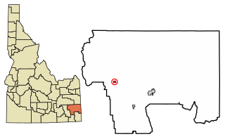
Bancroft is a city in the Gem Valley in Caribou County, Idaho, United States. The population was 299 at the 2020 census, and 377 at the 2010 census.

<span class="mw-page-title-main">Soda Springs, Idaho</span> City in the United States

Soda Springs is a city in Caribou County, Idaho, United States. Its population was 3,133 at the time of the 2020 census. The city has been the county seat of Caribou County since the county was organized in 1919. In the 1860s, Soda Springs served as the seat of Oneida County.

<span class="mw-page-title-main">Wendell, Idaho</span> City in Idaho, United States

Wendell is a city in southern Gooding County, Idaho, United States. The population was 2,782 at the 2010 census.

<span class="mw-page-title-main">Hamer, Idaho</span> City in Idaho, United States

Hamer is a city in Jefferson County, Idaho, United States. It is part of the Idaho Falls Metropolitan Statistical Area. The population was 83 at the 2020 census.

<span class="mw-page-title-main">Hazelton, Idaho</span> City in Idaho, United States

Hazelton is a city in Jerome County, Idaho, United States. The population was 807 at the 2020 census. It is part of the Twin Falls, Idaho Micropolitan Statistical Area.

<span class="mw-page-title-main">Jerome, Idaho</span> City in Idaho, United States

Jerome is a city in and county seat of Jerome County, Idaho, United States. The population was 10,890 at the 2010 census, up from 7,780 in 2000. The city is the county seat of Jerome County, and is part of the Twin Falls Micropolitan Statistical Area. It is the second largest city in Idaho's Magic Valley region, second only to Twin Falls which is located 10 miles (16 km) southeast. Jerome's economy is largely agrarian, with dairy farming being one of the main revenue sources for the local economy.

<span class="mw-page-title-main">Dalton Gardens, Idaho</span> City in Kootenai County, Idaho, United States

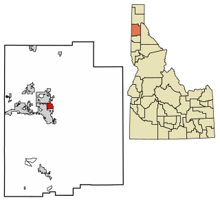
Dalton Gardens is a city in Kootenai County, Idaho, United States. It is considered a suburb of Coeur d'Alene and borders the city to the north and east. The city of Dalton Gardens is also part of the larger Spokane-Coeur d'Alene Combined Metropolitan Statistical Area which encompasses Kootenai County, Idaho. The population of Dalton Gardens was 2,335 at the time of the 2010 census.

<span class="mw-page-title-main">Stateline, Idaho</span> City in Idaho, United States

Stateline, officially the City of State Line, and historically known as State Line Village, is a city in Kootenai County, Idaho, United States, and is both the easternmost suburb of Spokane, Washington and the westernmost suburb of Coeur d'Alene, Idaho. The population was 39 at the 2020 census. The city is known for the adult services it provides which attract business from nearby Spokane and Coeur d'Alene. The unincorporated community of Spokane Bridge, Washington is located across the Spokane River to the southwest.

<span class="mw-page-title-main">Acequia, Idaho</span> City in Idaho, United States

Acequia is a city in Minidoka County, Idaho, United States. The population was 131 at the 2020 census. It is part of the Burley, Idaho Micropolitan Statistical Area. The town is named for the Spanish word for canal.

<span class="mw-page-title-main">Culdesac, Idaho</span> City in Idaho, United States

Culdesac is a city in Nez Perce County, Idaho, United States. The population was 380 at the 2010 census. It is part of the Lewiston, ID-WA Metropolitan Statistical Area.

<span class="mw-page-title-main">Fruitland, Idaho</span> City in Payette County, Idaho, United States

Fruitland is a city along the Snake and Payette rivers in Payette County, Idaho, United States. It lies along U.S. Route 95 in the Treasure Valley of southwest Idaho, about 50 miles (80 km) west of Boise on the border with Oregon. It is part of the Ontario Micropolitan Area. Fruitland is named after apple orchards that surround the community, and its slogan is "The Big Apple of Idaho."

<span class="mw-page-title-main">Castleford, Idaho</span> City in Idaho, United States

Castleford is a city in Twin Falls County, Idaho, United States. The population was 226 at the 2010 census. It is part of the Twin Falls, Idaho Micropolitan Statistical Area.

<span class="mw-page-title-main">Hansen, Idaho</span> City in Idaho, United States

Hansen is a city in Twin Falls County, Idaho, United States. The population was 1,086 at the 2020 census, and 1,144 at the 2010 census. It is part of the Twin Falls, Idaho Micropolitan Statistical Area.

<span class="mw-page-title-main">Oakley, Kansas</span> City in Gove / Logan / Thomas Counties of Kansas

Oakley is a city in Gove, Logan, and Thomas counties in the U.S. state of Kansas. It is the county seat of Logan County. As of the 2020 census, the population of the city was 2,046.

References

  1. "Oakley Historical Area". Visit Southern Idaho. Retrieved May 27, 2024.
  2. "Mayor". City of Oakley. Retrieved May 25, 2024.
  3. "2019 U.S. Gazetteer Files". United States Census Bureau. Retrieved July 9, 2020.
  4. 1 2 "U.S. Census website". United States Census Bureau . Retrieved December 18, 2012.
  5. Spokesman-Review Archived 2016-03-04 at the Wayback Machine - 2010 census - Oakley, Idaho - accessed 2011-12-27
  6. "Oakley Academy" . Retrieved May 27, 2024.
  7. "Oakley Academy" . Retrieved May 27, 2024.
  8. "Oakley Valley Arts Council" . Retrieved May 27, 2024.
  9. "US Gazetteer files 2010". United States Census Bureau. Archived from the original on January 12, 2012. Retrieved December 18, 2012.
  10. 1 2 "NOAA Online Weather Data – NWS Pocatello". National Weather Service. Retrieved February 20, 2023.
  11. "U.S. Climate Normals Quick Access – Station: Oakley, ID". National Oceanic and Atmospheric Administration. Retrieved February 20, 2023.
  12. "Census of Population and Housing". Census.gov. Retrieved June 4, 2015.
  13. "U.S. Census website". United States Census Bureau . Retrieved January 31, 2008.
  14. 1 2 "Pioneer Days Celebration". City of Oakley. Retrieved May 25, 2024.
  15. "Pioneer Days events set for Oakley". Magicvalley.com. Retrieved October 18, 2018.
  16. "Oakley Tour of Homes - Southern Idaho Tourism". Visitsouthidaho.com. Retrieved October 18, 2018.
  17. "Oakley Is A Unique Village In Idaho Where Time Stands Still". March 21, 2023. Retrieved May 27, 2024.
  18. "Oakley Valley Historical Museum Oakley". Visit Southern Idaho. Retrieved May 25, 2024.
  19. "Oakley Free Library". Oakley Free Library District. Retrieved May 25, 2024.
  20. "Schools". City of Oakley. Retrieved May 25, 2024.
  21. Dittenber, Sadie (January 3, 2023). "Day 1: Debbie gets sworn in". Idaho Education News.