
Hilpoltstein is a town in the district of Roth, in Bavaria, Germany. It is situated 10 km southeast of Roth bei Nürnberg and 30 km south of Nuremberg, close to the lake 'Rothsee.

Gräfenberg is a Franconian town in the district of Forchheim, in Bavaria, Germany. It is situated 16km southeast of Forchheim and 25km northeast of Nuremberg.

Wassertrüdingen is a town in the district of Ansbach, Middle Franconia, Bavaria, Germany. It is between the Hesselberg, the only Franconian mountain with a view on the Alps, the wooded heights of the Oettinger Forest and the foothills of the Hahnenkamm. The Fränkisches Seenland recreation area is 15 kilometers away. Altentrüdingen, Fürnheim, Geilsheim, Obermögersheim, Reichenbach und Schobdach are part of Wassertrüdingen

Scheinfeld is a town in the Neustadt (Aisch)-Bad Windsheim district, in Bavaria, Germany. It is situated 14 km northwest of Neustadt (Aisch), and 40 km east of Würzburg. Schloss Schwarzenberg is adjacent to the town. The town is home to an Adidas testing factory.

Feldkirchen is a municipality in the district of Munich, Bavaria, Germany. It is located 10 km east of Munich and has 5,987 inhabitants. Feldkirchen was first mentioned in a document dated 853.

Haiming is a municipality in the district of Altötting in Bavaria in Germany, located between the rivers Inn and Salzach.
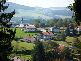
Neuschönau is a municipality in the district of Freyung-Grafenau, in the Lower Bavaria region of Bavaria, in Germany.
Wallgau is a municipality in the district of Garmisch-Partenkirchen, in Bavaria, Germany.

Eching am Ammersee is a municipality in the district of Landsberg in Bavaria in Germany. It has a size of 6.15km2.

Sugenheim is a municipality in the district of Neustadt (Aisch)-Bad Windsheim in Bavaria, Germany. The municipality consists of eleven villages:

Speinshart is a municipality in the district of Neustadt an der Waldnaab in Bavaria, Germany. The municipality gained its name from the monastery Speinshart which was built between 1692 and 1697 by Wolfgang Dientzenhofer.

Alfeld is a municipality in the district of Nürnberger Land in Bavaria in Germany. Alfeld has around 1100 inhabitants (2013) and is famous for their traditional Kermesse which the people celebrate at the end of August every year.

Oberstaufen is a municipality in the district of Oberallgäu in Bavarian Swabia, Germany, situated on the B 308 road from Lindau to Immenstadt.

Seeg is a municipality in the district of Ostallgäu in Bavaria in Germany.

Nordheim vor der Rhön is a municipality in the district of Rhön-Grabfeld in Bavaria in Germany. It is located in the upper Streu valley, between Ostheim and Fladungen.

Stockheim is a municipality in the district of Rhön-Grabfeld in Bavaria in Germany. It is located in the Streu valley between Ostheim and Mellrichstadt.

Aschau im Chiemgau is a municipality and a village in the district of Rosenheim in Bavaria in Germany.

Rimsting is a municipality in the district of Rosenheim in Bavaria in Germany. It lies on the shore of Lake Chiemsee between the municipalities of Prien am Chiemsee and Bad Endorf.

Seeshaupt is a municipality in the Weilheim-Schongau district, in Bavaria, Germany.

Kirchhaslach is a municipality in the district of Unterallgäu in Bavaria, Germany. The town has a municipal association with Babenhausen, Bavaria.


