
Richmond International Airport is a joint civil-military airport in Sandston, Virginia, United States, an unincorporated community. The airport is about 7 miles (11 km) southeast of downtown Richmond, the capital of the Commonwealth of Virginia. Richmond International Airport is the busiest airport in central Virginia and the third-busiest in the state behind Washington Reagan and Washington Dulles. RIC covers 2,500 acres of land.

Key West International Airport is an international airport located in the City of Key West in Monroe County, Florida, United States, 2 miles east of the main commercial center of Key West.
Panama City–Bay County International Airport(IATA: PFN, ICAO: KPFN, FAA LID: PFN) was a public airport 3 miles (4.8 km) northwest of Panama City, in Bay County, Florida. It was owned and operated by the Panama City–Bay County Airport and Industrial District. All airline services moved to the Northwest Florida Beaches International Airport on May 22, 2010, but the airfield was open to general aviation aircraft until October 1, 2010. The grounds will eventually be turned over to LUK-MB1 LLC, which plans to remove the runways and build homes, shops, walking trails and a marina.

Billings Logan International Airport is in the western United States, two miles northwest of downtown Billings, in Yellowstone County, Montana. It is the fourth largest airport in Montana, having been surpassed in recent years by Bozeman, Missoula, and Flathead County (Kalispell) in both number of gates as well as annual enplanements. Owned by the city of Billings, the airport is on top of the Rims, a 500-foot (150 m) cliff overlooking the downtown core, and covers 2,500 acres of land.
Newport News/Williamsburg International Airport is in Newport News, Virginia, United States, and serves the Hampton Roads area along with Norfolk International Airport in Norfolk. The airport is owned and operated by the Peninsula Airport Commission, a political subdivision of the Commonwealth of Virginia. PHF covers 1,800 acres.

Cape Cod Gateway Airport, also known as Boardman/Polando Field and formerly known as Barnstable Municipal Airport, is a public airport located on Cape Cod, one mile (1.6 km) north of the central business district of Hyannis, in Barnstable County, Massachusetts, United States. This airport is publicly owned by Town of Barnstable. It is Cape Cod's major airport as well as an air hub for the Cape and the Islands. The airport is served by scheduled commercial flights as well as charters and general aviation. Barnstable Municipal Airport served as a hub for Nantucket-based commuter airline Island Airlines until its shutdown in 2015.

General William J. Fox Airfield is a county-owned, public airport in Los Angeles County, California, five miles northwest of Lancaster, California, United States. Locally known as Fox Field, the airport serves the Antelope Valley. The airport is named after Brigadier General William J. Fox, "a Marine war hero, a movie stunt man, the first Los Angeles County engineer and, for 20 years after his retirement, a cowboy."

Barkley Regional Airport is an American domestic airport in West Paducah, Kentucky, 14 miles west of Paducah in McCracken County. It is used for general aviation and sees one airline, subsidized by the Essential Air Service program.

Monroe Regional Airport is a public use airport in Ouachita Parish, Louisiana, United States. The airport is owned by the City of Monroe and is located within the city limits three nautical miles (6 km) east of its central business district.
Greenbrier Valley Airport is three miles north of Lewisburg in Greenbrier County, West Virginia. Contour Airlines schedules airline flights, subsidized by the Essential Air Service program, to Charlotte Douglas International Airport. Federal Aviation Administration records say the airport had 10,902 passenger boardings (enplanements) in calendar year 2021 and 10,048 in 2022. The National Plan of Integrated Airport Systems for 2023–2027 called it a primary commercial service airport based on enplanements in 2021.

Daytona Beach International Airport is a county-owned airport located three miles (5 km) southwest of Daytona Beach, next to Daytona International Speedway, in Volusia County, Florida, United States. The airport has 3 runways, a six-gate domestic terminal, and an international terminal. Daytona Beach is the headquarters of Embry-Riddle Aeronautical University.

Quincy Regional Airport is a city-owned airport 12 miles east of Quincy, a city in Adams County, Illinois, United States. It is used for general aviation but also sees Southern Airways Express flights to Chicago's O'Hare International Airport and St. Louis Lambert International Airport, a service which is subsidized by the federal government's Essential Air Service program at a cost of $1,956,856. The Federal Aviation Administration (FAA) National Plan of Integrated Airport Systems for 2023–2027 categorized it as a national non-primary commercial service facility.

McAllister Field is a public airport three miles south of Yakima, in Yakima County, Washington. Owned by the City of Yakima, it is used for general aviation and commercial air service. Yakima is served by one scheduled passenger air carrier and two non-scheduled carriers. Sun Country Airlines operates charter flights to Laughlin, NV and Xtra Airways operates charter flights to Wendover, NV.

Drake Field is a public airport three miles south of Fayetteville, in Washington County, Arkansas. It is also known as Fayetteville Executive Airport and was formerly Fayetteville Municipal Airport.
Angelina County Airport is a county-owned, public-use airport in Angelina County, Texas, United States. The airport is located seven nautical miles (13 km) southwest of the central business district of Lufkin, Texas.
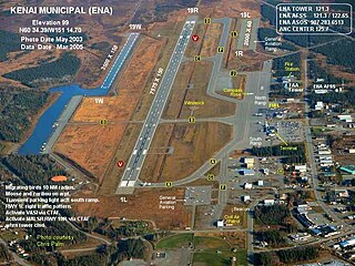
Kenai Municipal Airport is a city-owned, public-use airport located in Kenai, a city in the Kenai Peninsula Borough of the U.S. state of Alaska.

The Florida Keys Marathon International Airport is a public airport located along the Overseas Highway (US1) in Marathon, in Monroe County, Florida, United States. The airport covers 197 acres (80 ha) and has one runway.

Piedmont Airlines was a local service carrier, a scheduled carrier in the United States that operated from 1948 to 1989, when it merged into USAir. Its headquarters were at One Piedmont Plaza in Winston-Salem, North Carolina, a building that is now part of Wake Forest University.

Purdue University Airport is a public-use airport in Tippecanoe County, Indiana, United States. Owned by Purdue University, the airport is 2 nautical miles southwest of the central business district of Lafayette, Indiana, in West Lafayette. Because of the heavy traffic generated by Purdue University and its flight programs, Purdue University Airport is one of the busiest airports in Indiana, second only to nearby Indianapolis International Airport.

Trenton–Mercer Airport is a county-owned, joint civil–military, public airport located four miles northwest of Trenton in the West Trenton section of Ewing Township, Mercer County, New Jersey. Formerly known as Mercer County Airport, the airport serves one scheduled airline plus general and corporate aviation. The U.S. Department of Transportation reports that approximately 301,000 passengers arrived and 300,000 departed at the airport in the 12 months ending July 2023, for a total of 601,000 passengers.


