Franche-Comté is a cultural and historical region of eastern France. It is composed of the modern departments of Doubs, Jura, Haute-Saône and the Territoire de Belfort. In 2016, its population was 1,180,397.

Vosges is a department in the Grand Est region in Northeastern France. It covers part of the Vosges mountain range, after which it is named. Vosges consists of 17 cantons and 507 communes, 273 of which are classified as urban and of which 234 are classified as rural, including Domrémy-la-Pucelle, where Joan of Arc was born. In 2019, it had a population of 364,499 with an area of 5,874 km2 ; its prefecture is Épinal.
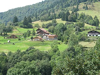
The Vosges are a range of low mountains in Eastern France, near its border with Germany. Together with the Palatine Forest to the north on the German side of the border, they form a single geomorphological unit and low mountain range of around 8,000 km2 (3,100 sq mi) in area. It runs in a north-northeast direction from the Burgundian Gate to the Börrstadt Basin, and forms the western boundary of the Upper Rhine Plain.

Île de la Cité is an island in the river Seine in the center of Paris. In the 4th century, it was the site of the fortress of the Roman governor. In 508, Clovis I, the first King of the Franks, established his palace on the island. In the 12th century, it became an important religious center, the home of Notre-Dame cathedral, and the royal chapel of Sainte-Chapelle, as well as the city's first hospital, the Hôtel-Dieu. It is also the site of the city's oldest surviving bridge, the Pont Neuf.

Raon-l'Étape is a commune in the Vosges Department in Grand Est in northeastern France.

Saint-Dié-des-Vosges, commonly referred to as just Saint-Dié, is a commune in the Vosges department in Grand Est in northeastern France.

The Colmar Pocket was the area held in central Alsace, France, by the German Nineteenth Army from November 1944 to February 1945, against the U.S. 6th Army Group during World War II. It was formed when 6th AG liberated southern and northern Alsace and adjacent eastern Lorraine, but could not clear central Alsace. During Operation Nordwind in December 1944, the 19th Army attacked north out of the Pocket in support of other German forces attacking south from the Saar into northern Alsace. In late January and early February 1945, the French First Army cleared the Pocket of German forces.
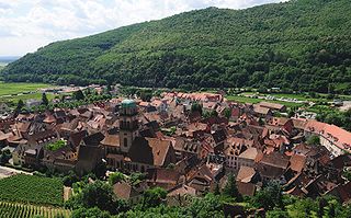
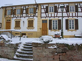
Kaysersberg is a historical town in Alsace in northeastern France. The name is German for Emperor's Mountain. The high fortress that dominates the town serves as a reminder of both its strategic importance and its warlike past.

Thann is a commune in the northeastern French department of Haut-Rhin, in Grand Est. It is the sous-préfecture of the arrondissement of Thann-Guebwiller and part of the canton of Cernay. Its inhabitants are known as Thannois.

Saint-Maime is a commune in the Alpes-de-Haute-Provence department in southeastern France. It is located in the Luberon national park and is home to the 12th century chapel Chapelle Sainte-Agathe.
Erckartswiller is a commune, in the Bas-Rhin department in Grand Est in north-eastern France. It is part of the arrondissement of Saverne and the canton of Ingwiller.

Vaux-de-Cernay Abbey was a Cistercian monastery in northern France (Ile-de-France), situated in Cernay-la-Ville, in the Diocese of Versailles, Yvelines.

The Belfort Gap or Burgundian Gate is the area of relatively flat terrain between the Vosges Mountains to the north and the Jura Mountains to the south. It marks the watershed between the drainage basins of the River Rhine to the east and the River Rhône to the west, part of the European Watershed between the North Sea and the Mediterranean Sea. It is also the boundary between the historic regions of Burgundy to the west and Alsace to the east, and as such has marked the Franco-German border for long periods of its history.

The Fortified Sector of Colmar was the French military organization that in 1940 controlled the section of the French frontier with Germany in the vicinity of Colmar. The fortifications were built as part of France's Maginot Line defensive strategy, but the sector lacks the large interconnected fortifications found along France's land border with Germany. The sector's principal defense was the Rhine itself, which could be crossed only by boat or by seizing a bridge crossing. The sector's fortifications chiefly took the form of casemates and blockhouses. The SF Colmar was flanked to the north by the Fortified Sector of the Lower Rhine to the north and the Fortified Sector of Mulhouse to the south. The Colmar sector was directly attacked by German forces on 15 June 1940, capturing or destroying most of the fortifications in the sector in three days.

Route des Crêtes is an 89 km (55 mi) road in the Vosges Mountains in eastern France, which passes through the Parc Naturel Régional des Ballons des Vosges. It connects Sainte-Marie-aux-Mines (north) with Cernay (south) and runs on the border of the departements of Haut-Rhin (68) and Vosges (88). Most of the route is at an elevation in excess of 950 m (3,117 ft), with the highest point being at the Col du Grand Ballon. The road is generally open from April to November, but most of the route is closed in the winter by snow.

The Battle of Hartmannswillerkopf was a series of engagements during the First World War fought for the control of the Hartmannswillerkopf peak in Alsace in 1914 and 1915. The peak is a pyramidal rocky spur in the Vosges mountains, about 5 km (3.1 mi) north of Thann, standing at 956 m (3,136 ft) and overlooking the Alsace Plain, Rhine valley and the Black Forest in Germany. Hartmanswillerkopf was captured by the French army during the Battle of Mulhouse (7–10, 14–26 August 1914). From the vantage point, Mulhouse and the Mulhouse–Colmar railway could be seen and the French railway from Thann to Cernay and Belfort shielded from German observation.

Grand Est is an administrative region in Northeastern France. It superseded three former administrative regions, Alsace, Champagne-Ardenne and Lorraine, on 1 January 2016 under the provisional name of Alsace-Champagne-Ardenne-Lorraine, as a result of territorial reform which had been passed by the French Parliament in 2014.
The canton of Le Val-d'Ajol is an administrative division of the Vosges department, in northeastern France. It was created at the French canton reorganisation which came into effect in March 2015. Its seat is in Le Val-d'Ajol.
The canton of Maîche is an administrative division of the Doubs department, eastern France. Its borders were modified at the French canton reorganisation which came into effect in March 2015. Its seat is in Maîche.
