Old Bridge, Pontypridd

Last updated

Old Bridge
Pontypridd New Bridge (b).jpg
Old Bridge (foreground)
Victoria Bridge (background)
Coordinates 51°36′18″N3°20′18″W / 51.604910°N 3.338220°W / 51.604910; -3.338220
Carriesfoot traffic
Crosses River Taff
Locale Pontypridd, Wales
Official nameWilliam Edwards Bridge
Maintained by Rhondda Cynon Taf
Heritage statusScheduled monument
Characteristics
Design Arch bridge
Width11 ft (3 m)
Longest span140 feet (43 m)
Clearance below 34 ft (10 m)
History
Designer William Edwards
Construction start1746
Opened1756
Collapsed1748
Statistics
TollFree public access
Listed Building – Grade I
Official namePontypridd Bridge [1]
Designated25 May 1962 [1]
Reference no.13497 [1]
Official namePontypridd Bridge [2]
Reference no.GM015 [2]
Location
Old Bridge, Pontypridd

The Old Bridge (Welsh : Yr Hen Bont), which is now also known as the William Edwards Bridge or Pontypridd Bridge, [3] [4] was originally known as the New Bridge or Newbridge, [3] [5] is an arched single-span footbridge that spans the River Taff at Pontypridd in Wales. The bridge was built by William Edwards and was completed in 1756. [4] The bridge now has statutory protection as a scheduled ancient monument and is grade I listed. [1] [6] [7]

Contents

Pontypridd

The bridge in 1813 when it was known as New Bridge or Pont-y-Prydd New Bridge, or Pont-Y-Prydd, Glamorganshire.jpeg
The bridge in 1813 when it was known as New Bridge or Pont-y-Prydd

In the early 18th century Pontypridd, then known as Pont-y-tŷ-pridd (The bridge of the earthen house), [8] was a tiny hamlet. [9] Pont-y-tŷ-pridd took its name from the original bridge of the same name, [9] however very little is known of that ancient ford with stepping stones, which ran alongside the current Old Bridge, [10] and was used only when the river ran low. [10] Possibly in 1744 or after the bridge was built, [10] Pont-y-tŷ-pridd became known as Newbridge or New Bridge after the William Edwards Bridge. [10] [11] By 1856, Newbridge had been renamed Pontypridd. [12]

In 1746 when William Edwards was just 27 years of age, [13] he was commissioned by the Hundreds of Miskin and Caerphilly to build a three-arch bridge across the River Taff. [14] For this he was paid £500, on condition that he would maintain it for seven years. [4] [14]

Construction

The first bridge

The first bridge to be constructed was a three-arch stone bridge, which was built in 1746. It was destroyed by a heavy storm which caused the River Taff to flood about two years later. [15] A large amount of debris came down the river, which then become trapped against the two abutments supporting the bridge. The weight and force of the debris ultimately destroyed the bridge, which was then swept away down the river. [3]

The second bridge

After the destruction of the first bridge over the fast-flowing River Taff, Edwards designed a more radical 140 ft (43 m) single-arch bridge that would eliminate the possibility of debris destroying the bridge due to the flooding of the River Taff. [3] The second bridge was built from 1748, however two reports differ as to what actually happened during this second attempt. Thomas Morgan, a contemporary of Edwards, said that "…when he (Edwards) had almost finished the arch, the centre timber work gave way and all fell to the bottom." However, The National Library of Wales has a contemporary work known as the Plasybrain manuscript which says, "Just after the first single arch was finished and before the centre was struck, a flood came and carried all away." It is not clear which account is accurate, although it is clear that the attempt failed. [3]

The third bridge

The single-arch bridge was rebuilt and was completed. It stood for about six weeks before it failed again. The weight of the materials in the bridge was not balanced on either side of the keystone, which gradually forced the stone out of position as traffic on the bridge created small vibrations and movement, and the bridge collapsed. [3] In the Theory of Arches and Pontypridd, it states that "the weight of the bridge was either too great on the haunches or too little on the crown." At this stage Edwards was either encouraged or forced to try again with extra money being provided to cover his losses for the earlier attempts. [13]

The fourth bridge

The Old Bridge, when it was known as Newbridge A remarkable bridge at Pentytypridd in Glamorganshire.jpeg
The Old Bridge, when it was known as Newbridge

The final design of the bridge included three cylindrical voids (holes) of 2.7 m (8.9 ft), 1.7 m (5.6 ft) and 1.1 m (3.6 ft) on each side on the bridge. [16] This reduced the weight and pressure on the crown and the bridge is still in operation today, although it is now only used for foot traffic. The Theory of Arches and Pontypridd states that as a bridge for commerce, it was a failure, as it was "only eleven feet wide between the parapets and so steep that wagons had to use a 'chain and drag' to descend from the crown." [3] [13]

The 140 ft Old Bridge surpassed the 130 ft (40 m) Old Walton Bridge as the longest single-span bridge in Great Britain and remained the longest bridge for another 40 years. [13] [17] It was also one of the few bridges in Europe at the time, and indeed worldwide, whose span exceeded the 40 m mark.

The whole project (including the three failed attempts) cost Edwards a total of £1,153 18s. 2d. (approximately £1,153.91), and consequently his loss exceeded £600. [9] It was reported that Edwards' attempts to build the bridge over the River Taff left him in considerable debt; Thomas Morgan reported that "…the mason was considerably in debt and greatly discouraged. But the Lords Talbot and Windsor, who have estates in the neighbourhood, pitied his case, and being willing to encourage such an enterprising genius, most generously promoted a subscription among the gentry in those parts." [3]

Subsequent history

The Old Bridge with steps ascending the bridge The Old Bridge and Victoria Bridge, Pontypridd.jpg
The Old Bridge with steps ascending the bridge

The Old Bridge was so steep that horse carts had difficulty crossing it. [18] By 1857, a new bridge, the Victoria Bridge, was built next to the Old Bridge, which was paid for by the people of Pontypridd. [18] The Victoria Bridge is a three-arch bridge, built by Thomas Jenkins, that did not have a problem with roadway steepness. [19]

Since the bridge was opened in 1756, it has been the subject for many landscape artists, including Richard Wilson and Turner. [20]

The Old Bridge is now a scheduled monument and is also depicted in emblems of local sport teams, including Pontypridd F.C. Pontypridd RFC and Cilfynydd RFC. [20] Artist Lulu Quinn was commissioned by Rhondda Cynon Taf County Borough Council to illuminate the Old Bridge as part of a regeneration programme for Pontypridd called the Monument Illumination Scheme. [21] Initial tests to illuminate the bridge took place on 19 August 2008, [22] and the project was officially launched after successful testing. [21]

Bridge imagery

The crest of Pontypridd Rugby Football Club displays an image of the Old Bridge with its cylindrical voids (holes) Pontypridd RFC crest.jpg
The crest of Pontypridd Rugby Football Club displays an image of the Old Bridge with its cylindrical voids (holes)

Representations of Old Bridge can be seen in local heraldic and civic stationery, including the crest of Pontypridd Rugby Football Club, Pontypridd Football Club and Cilfynydd Rugby Football Club. [23] The community-to-community organisation PONT (Partnerships Overseas Networking Trust), also bases its logo upon the Bridge. [24] Pontypridd High School in Cilfynydd incorporates the bridge design into the school shield, [25] as does Pontypridd Town Council with its logo representing the South Wales Valleys and a section of the Old Bridge in the foreground. [26] Pontypridd Male Voice Choir also incorporates the Old Bridge in the choir logo. [27]

See also

Related Research Articles

<span class="mw-page-title-main">Pontypridd</span> Town in Wales

Pontypridd is a town and a community in Rhondda Cynon Taf, Wales.

<span class="mw-page-title-main">Rhondda Cynon Taf</span> County borough in Wales

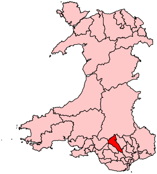
Rhondda Cynon Taf is a county borough in the south-east of Wales. It consists of five valleys: the Rhondda Fawr, Rhondda Fach, Cynon, Taff and Ely valleys, plus a number of towns and villages away from the valleys.

<span class="mw-page-title-main">Ynysybwl</span> Human settlement in Wales

Ynysybwl is a village in Cwm Clydach in Wales. It is situated in the county borough of Rhondda Cynon Taf, roughly 15 miles (24 km) north-north-west of Cardiff, 4 miles (6 km) north of Pontypridd and 16 miles (26 km) south of Merthyr Tydfil, and forms part of the community of Ynysybwl and Coed-y-Cwm.

<span class="mw-page-title-main">Taff Trail</span> Walking and cycling track in South Wales

The Taff Trail is a popular walking and cycle path that runs for 55 miles (89 km) between Cardiff Bay and Brecon in Wales. It is so named because it follows the course of the River Taff. Along much of its length, it follows the National Cycle Network Route 8 that continues to Holyhead, and is substantially off-road.

<span class="mw-page-title-main">River Taff</span> River in Wales which flows into Cardiff Bay

The River Taff is a river in Wales. It rises as two rivers in the Brecon Beacons; the Taf Fechan and the Taf Fawr before becoming one just north of Merthyr Tydfil. Its confluence with the River Severn estuary is in Cardiff.

<span class="mw-page-title-main">Abercynon</span> Human settlement in Wales

Abercynon, is both a village and a community in the Cynon Valley within the unitary authority of Rhondda Cynon Taf, Wales. The community comprises the village and the districts of Carnetown and Grovers Field to the south, Navigation Park to the east, and Glancynon to the north.

<span class="mw-page-title-main">Cynon Valley (UK Parliament constituency)</span> Parliamentary constituency in the United Kingdom, 1983 onwards

Cynon Valley is a constituency in Wales represented in the House of Commons of the UK Parliament since 2019 by Beth Winter of the Labour Party.

<span class="mw-page-title-main">Pontypridd (UK Parliament constituency)</span> Parliamentary constituency in the United Kingdom, 1918 onwards

Pontypridd is a constituency represented in the House of Commons of the UK Parliament since 2019 by Alex Davies-Jones of the Labour Party.

<span class="mw-page-title-main">Taff's Well</span> Human settlement in Wales

Taff's Well is a semi-rural village, community and electoral ward located at the south easterly tip of Rhondda Cynon Taf, 6 miles (9.7 km) to the north of Cardiff, the capital city of Wales. Known locally as the 'Gates to the Valleys', it is separated from Gwaelod-y-Garth by the River Taff. Taff's Well is distinguished because it contains the only thermal spring in Wales. The tepid water is thought to rise along a fault-line from the Carboniferous Limestone, in somewhat similar manner to the warm springs at Bristol and Bath. Various religious groups regard it as a spiritual site.

<span class="mw-page-title-main">Taff-Ely</span> Former district of Mid Glamorgan, Wales

Taff-Ely was a local government district with borough status in Wales from 1974 to 1996.

<span class="mw-page-title-main">Rhondda Cynon Taf County Borough Council</span> Local government of Rhondda Cynon Taf, Wales

Rhondda Cynon Taf County Borough Council is the governing body for Rhondda Cynon Taf, one of the Principal Areas of Wales. The council headquarters are located in the community of Cwm Clydach on the outskirts of Tonypandy.

<span class="mw-page-title-main">Tonteg</span> Human settlement in Wales

Tonteg is a village around 3.7 miles (6 km) from Pontypridd, south Wales. It is 9 miles (14.5 km) north west of Cardiff and four miles (6.5 km) north east of Llantrisant. The village is within the community of Llantwit Fardre. Tonteg is to the north west of the Garth Mountain, on the west side of the River Taff valley, at the top of a hill known locally as Powerstation Hill. The hill gets its name from the Upper Boat power station which was situated at the bottom of the hill until it was demolished in 1972. Tonteg is next to Church Village and the boundaries between the two villages are blurred. A significant part of the Treforest Industrial Estate falls within the Willowford area of Tonteg.

<span class="mw-page-title-main">Cilfynydd</span> Human settlement in Wales

Cilfynydd is a village in the county borough of Rhondda Cynon Taf, Wales, a mile from the South Wales Valleys town of Pontypridd, and 13 miles north of the capital city, Cardiff. Cilfynydd is also an electoral ward for the county council and Pontypridd Town Council.

<span class="mw-page-title-main">Hopkinstown</span> Human settlement in Wales

Hopkinstown is a small village to the west of Pontypridd in the county borough of Rhondda Cynon Taf, Wales, alongside the River Rhondda. Hopkinstown is a former coalmining and industrial community, now a district in the town of Pontypridd within the Rhondda electoral ward. Neighbouring settlements are Pwllgwaun, Trehafod and Pantygraigwen, and the sub-districts of Troed-Rhiw-Trwyn and Gyfeillion.

<span class="mw-page-title-main">Graigwen</span> Village in Mid Glamorgan, Wales

Graigwen is the name of the large hill and the village or district located thereon, sited to the north of Pontypridd town centre and south of Glyncoch and Ynysybwl in the county borough of Rhondda Cynon Taf, Wales, and within the ancient parish of Llanwonno (Llanwynno). It falls within the Rhondda and Pontypridd Town electoral wards, and comprises the sub-districts of Pantygraigwen, Penygraigwen, the Whiterock Estate, and Lanwood. It is also bounded by the districts of Pwllgwaun and Hopkinstown.

<span class="mw-page-title-main">Graig, Pontypridd</span> Human settlement in Wales

Graig is a historic district of the town of Pontypridd, Rhondda Cynon Taf, South Wales. It is also the name of an electoral ward for the town and county councils.

<span class="mw-page-title-main">Trallwn</span> District in Rhondda Cynon Taf, Wales

Trallwn is a district, and as Trallwng, an electoral ward, within the town of Pontypridd, Rhondda Cynon Taf, South Wales, sited along the banks of the River Taff and falling within the historic parish of Eglwysilan. Trallwn comprises the subdistricts of Coedpenmaen (Coed-Pen-Maen), Ynysangharad and Pontypridd Common. Until recently Trallwn was also home to the famous Brown Lenox (Newbridge) Chain & Anchor Works at Ynysangharad, which was recently demolished. Also at Ynysangharad are some of the last remains of the Glamorganshire Canal which was used to transport coal and iron from the South Wales Valleys to the city of Cardiff. Ynysangharad is also home to Pontypridd's War Memorial Park - Ynysangharad Park.

<span class="mw-page-title-main">Grade I listed buildings in Rhondda Cynon Taf</span> List of buildings in county borough of Wales

Rhondda Cynon Taf is a county borough in South Wales. It is located to the north-west of Cardiff and covers an area of 424 km2 (164 sq mi). In 2021 the population was approximately 237,500.

<span class="mw-page-title-main">Cenarth Bridge</span> Bridge in Cenarth, Wales

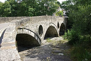
Cenarth Bridge, also spelt Kenarth Bridge, is a three arch bridge which spans the River Teifi at Cenarth, Carmarthenshire in Wales. The bridge was built between 1785 and 1787 and designed by David Edwards, the son of William Edwards who built the Old Bridge at Pontypridd. The bridge straddles the border between Carmarthenshire and Ceredigion. It is both a Grade II* listed structure and a scheduled monument.

References

Notes

  1. 1 2 3 4 "Pontypridd Bridge, Pontypridd". British Listed Buildings. Retrieved 14 February 2014.
  2. 1 2 "Pontypridd Bridge". ancientmonuments.uk. Retrieved 4 April 2021.
  3. 1 2 3 4 5 6 7 8 "The History of the Old Bridge". Rhondda Cynon Taf County Borough Council . Retrieved 22 February 2012.
  4. 1 2 3 "Pontypridd Bridge". Rhondda Cynon Taf County Borough Council. Archived from the original on 17 July 2009. Retrieved 16 January 2009.
  5. "PONTYPRIDD and district". someplacenamesinsouthwales.4t.com. Retrieved 16 January 2009.
  6. Cadw. "Pontypridd Bridge (Grade I) (13497)". National Historic Assets of Wales . Retrieved 11 April 2019.
  7. Cadw. "Pontypridd Bridge (GM015)". National Historic Assets of Wales . Retrieved 11 April 2019.
  8. "Pontypridd". BBC. Retrieved 19 January 2009.
  9. 1 2 3 "EDWARDS, WILLIAM (1719 - 1789), Independent minister, and architect". Dictionary of Welsh Biography . National Library of Wales . Retrieved 17 January 2009.
  10. 1 2 3 4 "Policing Pontypridd in the 1850s". South Wales Police . Retrieved 22 February 2012.
  11. "The Parish of Ystradyfodwg, by Benjamin Heath Malkin". GJR Williams. Archived from the original on 16 May 2008. Retrieved 17 January 2009.
  12. "Charles Bassett, the first Chairman and founder of the Pontypridd Market Company, c. 1856". Culturenet Cymru . Retrieved 17 January 2009.
  13. 1 2 3 4 Ruddock, Ted (2008). "Chapter 5: "The Theory of Arches and Pontypridd"". Arch Bridges and their Builders 1735–1835. Cambridge: Cambridge University Press. ISBN   978-0-521-09021-6 . Retrieved 19 January 2009.
  14. 1 2 Colvin, Howard (2008). A Biographical Dictionary of British Architects, 1600–1840 (Fourth ed.). Yale University Press. pp. 347–348. ISBN   978-0-300-12508-5 . Retrieved 17 January 2009.
  15. Skempton, A. W.; Mike Chrimes (2002). A Biographical Dictionary of Civil Engineers in Great Britain and Ireland: 1500 to 1830. Thomas Telford. pp. 211–212. ISBN   0-7277-2939-X.
  16. Three-dimensional centrifuge test of Pontypridd Bridge. Thomas Telford. 2000. ISBN   9780727728548.
  17. Skempton pp. 217–218
  18. 1 2 "Pontypridd Town". Partnerships Overseas Networking Trust. Archived from the original on 7 January 2009. Retrieved 15 February 2009.
  19. "'New' road bridge alongside William Edwards' 18th century single span bridge, Pontypridd". Culturenet Cymru. Retrieved 16 January 2009.
  20. 1 2 "History of Pontypridd". Pontypridd Town Council. Archived from the original on 3 March 2012. Retrieved 27 May 2009.
  21. 1 2 "Pontypridd Landmarks Illuminated". Rhondda Cynon Taf County Borough Council. Retrieved 27 May 2009.[ dead link ]
  22. "Pontypridd in Lights". Rhondda Cynon Taf County Borough Council. Retrieved 15 February 2009.[ dead link ]
  23. "A quick guide Introduction". Ponty Rugby Ltd. Retrieved 20 July 2009.
  24. "PONT – a partnership to fight poverty". PONT (Partnerships Overseas Networking Trust). Retrieved 22 October 2009.
  25. "Pontypridd High School". Pontypridd High School. Retrieved 20 July 2009.
  26. "Pontypridd Town Council – Putting Pride into Pontypridd". Pontypridd Town Council. Archived from the original on 26 December 2008. Retrieved 20 July 2009.
  27. "Pontypridd Male Voice Choir". Pontypridd Male Voice Choir.