
The Loop, one of Chicago's 77 designated community areas, is the central business district of the city and is the main section of Downtown Chicago. Home to Chicago's commercial core, it is the second largest commercial business district in North America after Midtown Manhattan in New York City, and contains the headquarters and regional offices of several global and national businesses, retail establishments, restaurants, hotels, and theaters, as well as many of Chicago's most famous attractions. It is home to Chicago's City Hall, the seat of Cook County, and numerous offices of other levels of government and consulates of foreign nations. The intersection of State Street and Madison Street is the origin point for the address system on Chicago's street grid. Most of Grant Park's 319 acres are in the eastern section of the community area. The Loop community area is bounded on the north and west by the Chicago River, on the east by Lake Michigan, and on the south by Roosevelt Road.

Michigan Avenue is a north-south street in Chicago that runs at 100 east on the Chicago grid. The northern end of the street is at Lake Shore Drive on the shore of Lake Michigan in the Gold Coast Historic District. The street's southern terminus is at Sibley Boulevard in the southern suburb of Dolton, but like many other Chicago streets, it exists in several disjointed segments.

Streeterville is a neighborhood in the Near North Side community area of Chicago, Illinois, United States, north of the Chicago River. It is bounded by the river on the south, the Magnificent Mile portion of Michigan Avenue on the west, and Lake Michigan on the north and east, according to most sources, although the City of Chicago only recognizes a small portion of this region as Streeterville. Thus, it can be described as the Magnificent Mile plus all land east of it. The tourist attraction of Navy Pier and Ohio Street Beach extend out into the lake from southern Streeterville. To the north, the East Lake Shore Drive District, where the Drive curves around the shoreline, may be considered an extension the Gold Coast. The majority of the land in this neighborhood is reclaimed sandbar.

Edgewater is a lakefront community area on the North Side of the city of Chicago, Illinois six miles north of the Loop. The most recently established of the city's 77 official community areas, Edgewater is bounded by Foster Avenue on the south, Devon Avenue on the north, Ravenswood Avenue on the west, and Lake Michigan on the east. Edgewater contains several beaches for residents to enjoy. Chicago's largest park, Lincoln Park, stretches south from Edgewater for seven miles along the waterfront, almost to downtown. Until 1980, Edgewater was part of Uptown, and historically it constituted the northeastern corner of Lake View Township, an independent suburb annexed by the city of Chicago in 1889. Today, Uptown is to Edgewater's south, Lincoln Square to its west, West Ridge to its northwest and Rogers Park to its north.

The Chicago Water Tower is a contributing property and landmark in the Old Chicago Water Tower District in Chicago, Illinois, United States, that is listed on the National Register of Historic Places. Built to enclose the tall machinery of a powerful water pump in 1869, it became particularly well known when it survived the Great Chicago Fire of 1871, although the area around it was burnt to the ground.

The Near North Side is the eighth of Chicago's 77 community areas. It is the northernmost of the three areas that constitute central Chicago, the others being the Loop and the Near South Side. The community area is located north and east of the Chicago River. To its east is Lake Michigan, and its northern boundary is the early 19th-century city limit of Chicago, North Avenue. In 2020 the Near North Side had 105,481 residents, surpassing Lake View as the largest Chicago community area by population. It is also the most densely populated community area and has the second most skyscrapers, after the Loop. With the exception of Goose Island, the Near North Side is known for its extreme affluence, typified by the Gold Coast, Magnificent Mile, Navy Pier, and skyscrapers.

The Near South Side is a community area of Chicago, Illinois, United States, just south of the downtown central business district, the Loop. The Near South Side's boundaries are as follows: North—Roosevelt Road ; South—26th Street; West—Chicago River between Roosevelt and 18th Street, Clark Street between 18th Street and Cermak Road, Federal between Cermak Road and the Stevenson Expressway just south of 25th Street, and Clark Street again between the Stevenson and 26th Street; and East—Lake Michigan.

The Magnificent Mile, sometimes referred to as The Mag Mile, is an upscale section of Chicago's Michigan Avenue, running from the Chicago River to Oak Street in the Near North Side. The district is located within downtown and one block east of Rush Street. The Magnificent Mile serves as the main thoroughfare between Chicago's Loop business district and its Gold Coast. It is generally the western boundary of the Streeterville neighborhood, to its east, and of River North to the west.
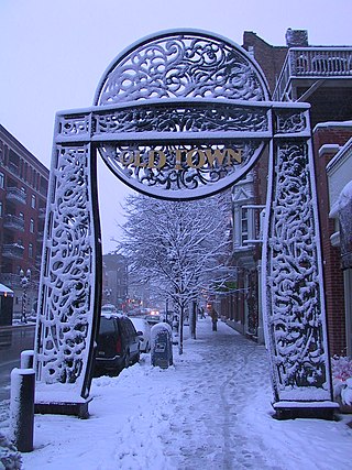
Old Town is a neighborhood and historic district in Near North Side and Lincoln Park, Chicago, Illinois, home to many of Chicago's older, Victorian-era buildings, including St. Michael's Church, one of seven buildings to survive the Great Chicago Fire.
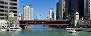
The DuSable Bridge is a bascule bridge that carries Michigan Avenue across the main stem of the Chicago River in downtown Chicago, Illinois, United States. The bridge was proposed in the early 20th century as part of a plan to link Grant Park (downtown) and Lincoln Park (uptown) with a grand boulevard. Construction of the bridge started in 1918, it opened to traffic in 1920, and decorative work was completed in 1928. The bridge provides passage for vehicles and pedestrians on two levels. An example of a fixed trunnion bascule bridge, it may be raised to allow tall ships and boats to pass underneath. The bridge is included in the Michigan–Wacker Historic District and has been designated as a Chicago Landmark.

U.S. Route 66 was a United States Numbered Highway in Illinois that connected St. Louis, Missouri, and Chicago, Illinois. The historic Route 66, the Mother Road or Main Street of America, took long distance automobile travelers from Chicago to Southern California. The highway had previously been Illinois Route 4 and the road has now been largely replaced with Interstate 55 (I-55). Parts of the road still carry traffic and six separate portions of the roadbed have been listed on the National Register of Historic Places.

Cermak Road, also known as 22nd Street, is a 19-mile, major east–west street on Chicago's near south and west sides and the city's western suburbs. In Chicago's street numbering system, Cermak is 2200 south, or twenty-two blocks south of the baseline of Madison Street. Normally, one mile comprises eight Chicago blocks, but the arterial streets Roosevelt Road, formerly named Twelfth Street and at 1200 South, and Cermak Road were platted before the eight-blocks-per-mile plan was implemented. Roosevelt Road is one mile south of Madison Avenue and there are twelve blocks within that mile. Cermak Road is two miles south of Madison Avenue and there are ten blocks within the mile between Roosevelt and Cermak Roads.

The Prairie Avenue District is a historic district in the Near South Side community area of Chicago, Illinois. It includes the 1800 and 1900 blocks of South Prairie Avenue and the 1800 block of South Indiana, and 211-217 East Cullerton. It was the site of the Battle of Fort Dearborn and became the city's most fashionable residential district after the Great Chicago Fire. It was designated a Chicago Landmark on December 27, 1979. The district was added to the National Register of Historic Places on November 15, 1972. The John J. Glessner House, designed and built by Henry Hobson Richardson in 1885–1886 at 1800 S. Prairie Avenue, has been restored as a historic house museum, and is open for public tours. In 2006, the Prairie District Neighborhood Alliance, a non-profit organization was formed to provide representation for thousands of South Loop residents, including the Prairie Avenue District, Central Station, Museum Park, Motor Row, and the South Michigan Avenue Corridor, as well as other areas of the Near South Side.

The Historic Michigan Boulevard District is a historic district in the Loop community area of Chicago in Cook County, Illinois, United States encompassing Michigan Avenue between 11th or Roosevelt Road, depending on the source, and Randolph Streets and named after the nearby Lake Michigan. It was designated a Chicago Landmark on February 27, 2002. The district includes numerous significant buildings on Michigan Avenue facing Grant Park. In addition, this section of Michigan Avenue includes the point recognized as the end of U.S. Route 66. This district is one of the world's best known one-sided streets rivalling Fifth Avenue in New York City and Edinburgh's Princes Street. It lies immediately south of the Michigan–Wacker Historic District and east of the Loop Retail Historic District.

The Chicago Avenue Pumping Station is a historic district contributing property in the Old Chicago Water Tower District landmark district. It is located on Michigan Avenue along the Magnificent Mile shopping district in the Near North Side community area of Chicago, Illinois. It is on the east side of Michigan Avenue opposite the Chicago Water Tower.

333 North Michigan is a skyscraper in the art deco style located in the Loop community area of Chicago, Illinois in the United States. Architecturally, it is noted for its dramatic upper-level setbacks that were inspired by the 1923 skyscraper zoning laws. Geographically, it is known as one of the four 1920s flanks of the Michigan Avenue Bridge that are contributing properties to the Michigan–Wacker Historic District, which is a U.S. Registered Historic District.

Rush Street is a one-way street in the Near North Side community area of Chicago in Cook County, Illinois, United States. The street, which starts at the Chicago River between Wabash and North Michigan Avenues, runs directly north until it slants on a diagonal as it crosses Chicago Avenue then it continues to Cedar and State Streets, making it slightly less than a mile long. One lane also runs southbound from Ohio Street (600N) to Kinzie Street (400N) as part of a two-way street segment. It runs parallel to and one block west of the Magnificent Mile on the two-way traffic North Michigan Avenue, which runs at 100 east up to 950 north. The street, which is also one block east of the one-way southbound Wabash Avenue, formerly ran slightly further south to the Chicago River where over time various bridges connected it to the Loop, Chicago's central business district.

The Michigan–Wacker Historic District is a National Register of Historic Places District that includes parts of the Chicago Loop and Near North Side community areas in Chicago, Illinois, United States. The district is known for the Chicago River, two bridges that cross it, and eleven high rise and skyscraper buildings erected in the 1920s. Among the contributing properties are the following Chicago Landmark structures:

This is a list of the National Register of Historic Places listings in Detroit, Michigan.
Prairie Avenue is a north–south street on the South Side of Chicago, which historically extended from 16th Street in the Near South Side to the city's southern limits and beyond. The street has a rich history from its origins as a major trail for horseback riders and carriages. During the last three decades of the 19th century, a six-block section of the street served as the residence of many of Chicago's elite families and an additional four-block section was also known for grand homes. The upper six-block section includes part of the historic Prairie Avenue District, which was declared a Chicago Landmark and added to the National Register of Historic Places.
 Old Chicago Water Tower District
 Chicago Water Tower
 View of Water Tower's place on Magnificent Mile


