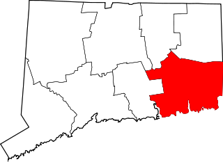
East Lyme is a town in New London County, Connecticut, United States. The population was 19,159 at the 2010 census. The villages of Niantic and Flanders are located in the town.

The Hampton Hill Historic District encompasses the historic village center of Hampton, Connecticut, a small rural community in Windham County. It is a linear district, extending for about 1 mile (1.6 km) along Connecticut Route 97, the major north-south route through the town, and laid out as a tree-lined boulevard. Most of the district's 62 historic buildings were built in the 19th century, with fifteen houses surviving from the 18th. Architecturally, they represent a cross-section of styles popular from the mid-18th to early 20th centuries, with vernacular forms most commonly found. One of the oldest buildings is a c. 1727 tavern, since converted to a private residence, while the town hall is located in an undistinguished 1920s former firehouse.

Plainfield Street Historic District is a historic district in Plainfield, Connecticut that encompasses the historic area of Plainfield Village, the town center of Plainfield. The district is linear, being located along Route 12 between Railroad Avenue and Route 14A. It has been the center of the town's civic life since its settlement in the early 18th century, and includes two centuries of architectural styles. The district was listed on the National Register of Historic Places in 1991.
The Sterling Hill Historic District encompasses a well-preserved early 19th-century rural village center on western edge of the town of Sterling, Connecticut. Centered at the junction of Plainfield Pike and Sterling Hill Road, it consists of a cluster of 19th and early 19th-century houses, and a church. Unlike other period villages, it has largely been unaffected by later development. It was listed on the National Register of Historic Places in 1986.
The South Coventry Historic District is a historic district encompassing the historic village center of South Coventry in the town of Coventry, Connecticut. The village, settled in the early 18th century, has served as Coventry's civic center, and also served as an economic center, with textile mills operating in the 19th century. The district was listed on the National Register of Historic Places in 1991.

The Agawam Center Historic District is a historic district that encompasses part of the historic center of Agawam, Massachusetts. The district covers most of the buildings along Elm Street and Main Street radiating out from their intersection in both directions. The district is predominantly residential in character, although it does contain a number of commercial, industrial, and civic buildings. Many of the buildings in the district stand at a uniform setback from the street, giving the district a coherent feel.

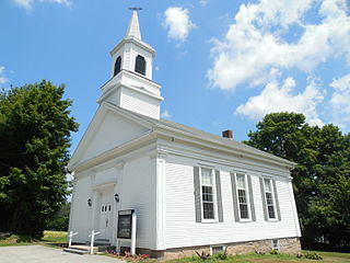
The Main Street Historic District encompasses the historic civic, commercial, and residential center of Durham, Connecticut. The district is primarily linear and runs along Main Street from between Higganum Road and Town House Road in the south to Talcott Lane in the north, and along Maple Avenue, which parallels Main Street. The district includes most of its colonial architecture, as well as many of its civic buildings. It was listed on the National Register of Historic Places in 1986.

The Torringford Street Historic District is a historic district on the east side of the city of Torrington, Connecticut. The district includes properties along Torringford Street, the main thoroughfare of the Torringford section of the city, between United States Route 202 and West Hill Road. The road is one of the oldest in Torrington, and this section is notable for containing a cross-section of well-preserved architecture from the 18th to the mid-20th centuries. The district was listed on the National Register of Historic Places in 1991.
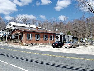
The Northford Center Historic District encompasses the historic village area of Northford in northern North Branford, Connecticut. The basically linear district extends along Middletown Avenue from the village center at its southern end, to a point beyond its northern junction with Old Post Road. The area was settled in the early 18th century, and was transformed into a rural industrial village in the 19th century by the locally prominent Maltby and Fowler families. It was listed on the National Register of Historic Places in 2002.

The York Historic District encompasses the historic village center of York, Maine, one of the oldest communities in the state. The expansive 1,700-acre (690 ha) district includes the oldest church in Maine, built by its oldest congregation in 1747, and the Old York Gaol, a National Historic Landmark that is one of the oldest public buildings in the United States. The district was listed on the National Register of Historic Places in 1973.

The Belltown Historic District encompasses the historic commercial and industrial main village of East Hampton, Connecticut. Settled in the 18th century, the community flourished in the 19th century as a center of bell making, with numerous firms engaged in the trade. The town center is reflective of this 19th-century success, with a broad diversity of period architecture, as well as surviving elements of the bellmaking industry. The district was listed on the National Register of Historic Places in 1985.
The Somers Historic District encompasses the historic civic and social center of the town of Somers, Connecticut. It stretches along Main Street, with extensions along Springfield Road and Battle Street, and includes a significant number of vernacular Federal and Greek Revival houses. It includes the town's early churches, as well as important civic buildings, including the town hall and library. The district was listed on the National Register of Historic Places in 1982.
The North Cove Historic District encompasses a historic waterfront community on North Cove Road in Saybrook, Connecticut. Laid out in the 17th century, the area has housing stock mostly built between 1700 and 1855, a period in which it flourished as a port and shipbuilding community. The district was listed on the National Register of Historic Places in 1994.

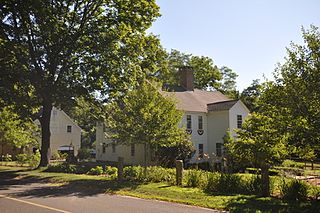
The Hadlyme North Historic District is an 81-acre (33 ha) historic district located in the southwest corner of the town of East Haddam, Connecticut. It represents the historic core of the village of Hadlyme, which straddles the town line, and consists primarily of two north-south roads, Town Street. The village arose around a church society founded in 1743, and grew with the development of small industries along area waterways. It was listed on the National Register of Historic Places in 1988.

The Old Saybrook South Green is a 20-acre (8.1 ha) historic district that encompasses the historic town green and nearby streets in Old Saybrook, Connecticut. Established in the 1630s, most of the buildings arrayed around the green were built between 1760 and 1900, and reflect the prosperity of the town, which was a major port and shipbuilding center. The district was listed on the National Register of Historic Places in 1976.

The Canaan Street Historic District encompasses the historic original town center of Canaan, New Hampshire. It is a basically linear district, running along Canaan Street roughly from Prospect Hill Street in the north to Moses Flower Lane in the south. The town flourished first as a stagecoach stop, and then as a resort colony in the late 19th century. The historic district was listed on the National Register of Historic Places in 1973. It included 60 contributing buildings.
The Plymouth Center Historic District encompasses historic early village center of Plymouth, Connecticut. Stretching along Main, North and South Streets from their junction, it flourished in the 19th century with small-scale industries, but declined late in the century with the separation of Thomaston and the more significant industrial development at Terryville. The district features colonial, Federal, and Greek Revival architecture and was added to the National Register of Historic Places in 1999, with a slight enlargement the following year.

Guilford Historic Town Center is a large historic district encompassing the entire town center of Guilford, Connecticut. It is centered on the town green, laid out in 1639, and extends north to Interstate 95, south to Long Island Sound, west to the West River, and east to East Creek. It includes more than 600 historic structures, most built between the late 17th and early 20th centuries, reflecting the town's growth and history during that time. It was listed on the National Register of Historic Places in 1976.