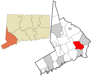
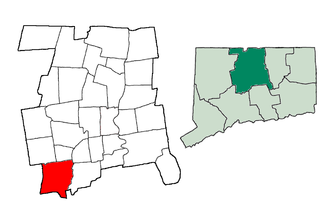
Trumbull is a town located in Fairfield County, Connecticut. It borders on the cities of Bridgeport and Shelton and the towns of Stratford, Fairfield, Easton and Monroe. The population was 36,018 during the 2010 census. Trumbull was the home of the Golden Hill Paugussett Indian Nation for thousands of years before the English settlement was made in 1639. The town was named after Jonathan Trumbull (1710–1785), a merchant, patriot and statesman when it was incorporated in 1797. Aviation pioneer Igor Sikorsky lived in Trumbull during his active years when he designed, built, and flew fixed-wing aircraft and put the helicopter into mass production for the first time.

Benjamin Silliman was an early American chemist and science educator. He was one of the first American professors of science, at Yale College, the first person to use the process of fractional distillation in America, and a founder of the American Journal of Science, the oldest continuously published scientific journal in the United States.

Scheelite is a calcium tungstate mineral with the chemical formula CaWO4. It is an important ore of tungsten (wolfram). Well-formed crystals are sought by collectors and are occasionally fashioned into gemstones when suitably free of flaws. Scheelite has been synthesized using the Czochralski process; the material produced may be used to imitate diamond, as a scintillator, or as a solid-state lasing medium. It was also used in radium paint in the same fashion as was zinc sulphide, and Thomas Edison invented a fluoroscope with a calcium tungstate-coated screen, making the images six times brighter than those with barium platinocyanide; the latter chemical allowed Röntgen to discover X-rays in early November 1895.
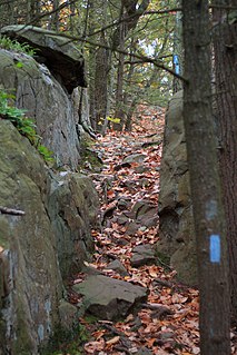
The Metacomet Trail is a 62.7-mile (100.9 km) Blue-Blazed hiking trail that traverses the Metacomet Ridge of central Connecticut and is a part of the newly designated New England National Scenic Trail. Despite being easily accessible and close to large population centers, the trail is considered remarkably rugged and scenic. The route includes many areas of unique ecologic, historic, and geologic interest. Notable features include waterfalls, dramatic cliff faces, woodlands, swamps, lakes, river flood plain, farmland, significant historic sites, and the summits of Talcott Mountain and the Hanging Hills. The Metacomet Trail is maintained largely through the efforts of the Connecticut Forest and Park Association.

Castle an Dinas is an Iron Age hillfort at the summit of Castle Downs near St Columb Major in Cornwall, UK and is considered one of the most important hillforts in the southwest of Britain. It dates from around the 3rd to 2nd century BCE and consists of three ditch and rampart concentric rings, 850 feet (260 m) above sea level. During the early 1960s it was excavated by a team led by Dr Bernard Wailes of the University of Pennsylvania during two seasons of excavation.

Hubbard Park, located in the Hanging Hills of Connecticut, is a wooded, mountainous park located just outside the city center of Meriden, Connecticut. It comprises approximately 1,800 acres (7.3 km2) of carefully kept woodlands, streams, dramatic cliff faces, flower gardens, and the James Barry bandshell and picnic spots, as well as its showpiece, Mirror Lake. The park is listed on the National Register of Historic Places.

Pendarvis is a historic site located in Mineral Point, Iowa County, Wisconsin, United States. The site, which is listed on the National Register of Historic Places, is made up of several 19th century cabins built by Cornish immigrants who came to Mineral Point to mine lead. Today the site is owned by the Wisconsin Historical Society and serves as a museum of Wisconsin's early lead mining history. Programs at the site also interpret the groundbreaking preservation work by Robert Neal and Edgar Hellum, begun during the Great Depression.
Branchville is a neighborhood of the town of Ridgefield in Fairfield County, Connecticut, United States, and is also the name of a Metro North railroad station. Branchville was listed as a census-designated place (CDP) prior to the 2020 census.
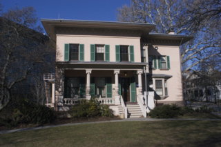
Nichols, a historic village in southeastern Trumbull in Fairfield County, Connecticut, is named after the family who maintained a large farm in its center for almost 300 years. The Nichols Farms Historic District, which encompasses part of the village, is listed on the National Register of Historic Places. Originally home to the Golden Hill Paugussett Indian Nation, the area was colonized by the English during the Great Migration of the 1630s as a part of the coastal settlement of Stratford. The construction of the Merritt Parkway through the village, and the subsequent closing of stores and factories, turned the village into a bedroom community in 1939. Aviation pioneer Igor Sikorsky lived in three separate homes in Nichols during his active years between 1928 and 1951, when he designed, built and flew fixed-wing aircraft and put the helicopter into mass production for the first time.

Nichols Farms is a historic area within the town of Trumbull, Connecticut. The Nichols Farms Historic District, which encompasses part of the area, is listed on the National Register of Historic Places.
The James Dwight Dana House, also known as the Dana House, is a historic 19th-century Italianate house at 24 Hillhouse Avenue in New Haven, Connecticut, in the United States. This building, designed by New Haven architect Henry Austin, was the home of Yale University geology professor James Dwight Dana (1813–95). It was declared a National Historic Landmark in 1965 for its association with Dana, who produced the first published works emphasizing that the study of geology was a much broader discipline than the examination of individual rocks.
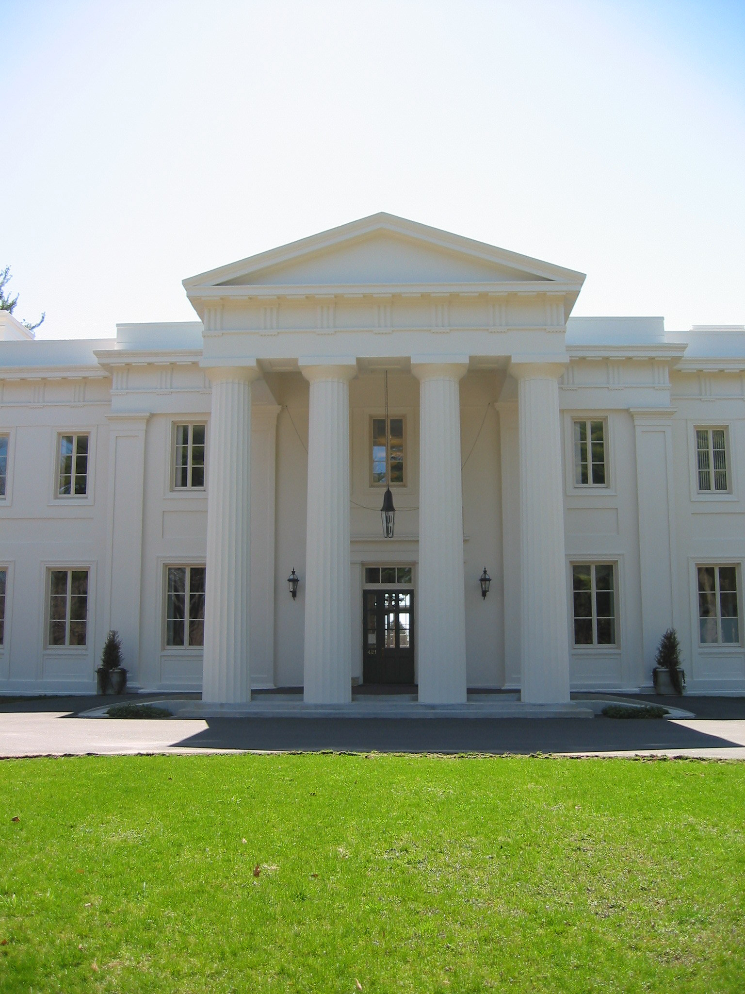
The Wadsworth Mansion at Long Hill Estate is located at 421 Wadsworth Street in Middletown, Connecticut. It is a 16,000-square-foot (1,500 m2) classical revival house situated on 103 acres (0.42 km2) wooded area. It is currently owned by the City of Middletown and is operated by the Long Hill Estate Authority. The mansion is the centerpiece of the Wadsworth Estate Historic District of 270 acres (1.1 km2), which includes the mansion's associated outbuildings, the Middletown portion of Wadsworth Falls State Park, the Nehemiah Hubbard House, and several barns and farmhouses along Laurel Grove Road such as the Harriet Cooper Lane House.

The Nipmuck Trail is a Blue-Blazed hiking trail "system" which meanders through 34.5 miles (55.5 km) of forests in northeast Connecticut. It is maintained by the Connecticut Forest and Park Association and is considered one of the Blue-Blazed hiking trails. There are two southern trail heads in the south of the town of Mansfield, Connecticut. The southwestern terminus is at a road shoulder parking place on Puddin Lane, and the southeastern terminus is a DEEP parking lot on North Windham Road at the southeast corner of Mansfield Hollow State Park. The northern terminus is at the north end of Breakneck Pond along the Massachusetts border in Nipmuck State Forest. Camping permits may be obtained for up to five separate locations for backpacking.

Trumbull, a town in Fairfield County, Connecticut, in the New England region of the United States, was originally home to the Golden Hill Paugussett Indian Nation, and was colonized by the English during the Great Migration of the 1630s as a part of the coastal settlement of Stratford.

The Pequonnock River is a 16.7-mile-long (26.9 km) waterway in eastern Fairfield County, Connecticut. Its watershed is located in five communities, with the majority of it located within Monroe, Trumbull, and Bridgeport. The river has a penchant for flooding, particularly in spring since the removal of a retention dam in Trumbull in the 1950s. There seems to be a sharp difference of opinion among historians as to just what the Indian word Pequonnock signifies. Some insist it meant cleared field or open ground; others are sure it meant broken ground; while a third group is certain it meant place of slaughter or place of destruction.

Water Mill is a historic watermill located at Water Mill in Suffolk County, New York, USA. It is a 2-story, heavy wood-frame structure with a wood-shingle exterior and composed of two building sections. There is a 2-story, square-shaped main section and 1-story, one-bay wing. Attached to the rear is a 2+1⁄2-story tower and 1-story glassed-in porch. The mill structure dates to the mid-17th century. It operated as a mill until the early 20th century. It is now a local museum.

The Paugussett Trail is a 14-mile (23 km) Blue-Blazed hiking trail "system" in the lower Housatonic River valley in Fairfield County and, today, is entirely in Shelton and Monroe, Connecticut. Much of the trail is in Indian Well State Park and the Town of Monroe's Webb Mountain Park. The mainline trail is primarily southeast to northwest with three short side or spur trails.

The Pikes Peak region is renowned for its rare mineral specimens. It is a favorite collecting area for rock hounds and serious collectors alike. Scientists from around the world come to Colorado to study the minerals of this region. Because the granite covers a large portion of the Colorado Front Range, there are good mineral collecting areas scattered all over the Pikes Peak region. The collecting localities range from near Colorado Springs on the south to just west of Denver on the north.
This is a list of the National Register of Historic Places listings in Southington, Connecticut.
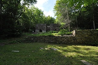
Mine Hills Preserve is a natural and historical conservation area on Mine Hills Road in northwestern Roxbury, Connecticut. Owned by the Roxbury Land Trust, it protects the site of a well-preserved 19th-century iron mine and furnace works. Several miles of trails provide access to abandoned quarry areas and the preserved remains of the iron works, whose uses are explained by informational panels. The preserve is open from dawn to dusk. The 360-acre (150 ha) preserve was listed on the National Register of Historic Places in 1979.


