Old Monroe, Missouri

Last updated

Old Monroe, Missouri
Old Monroe MO 03.png
Old Monroe in 2024
Lincoln County Missouri Incorporated and Unincorporated areas Old Monroe Highlighted.svg
Location of Old Monroe, Missouri
Coordinates: 38°55′55″N90°44′53″W / 38.93194°N 90.74806°W / 38.93194; -90.74806
Country United States
State Missouri
County Lincoln
Area
[1]
  Total0.37 sq mi (0.95 km2)
  Land0.36 sq mi (0.94 km2)
  Water0.01 sq mi (0.02 km2)
Elevation
[2]
443 ft (135 m)
Population
 (2020)
  Total249
  Density687.85/sq mi (265.62/km2)
Time zone UTC-6 (Central (CST))
  Summer (DST) UTC-5 (CDT)
ZIP code
63369
Area code 636
FIPS code 29-54416 [3]
GNIS feature ID2396052 [2]

Old Monroe is a city in Lincoln County, Missouri, United States. The population was 249 at the 2020 census.

Contents

History

Old Monroe was the site of Fort Howard. [4] It was laid out in 1819, and named after President James Monroe. [5] The name was prefixed with "Old" in order to avoid postal conflict with Monroe City. [6]

The Battle of the Sink Hole was fought on May 24, 1815, after the official end of the War of 1812, between Missouri Rangers and Sauk Indians led by Black Hawk. The Sauk were unaware, or did not care, that their British patrons had signed the Treaty of Ghent with the U.S. The battle was fought in a low spot near the mouth of the Cuivre River near the current day city of Old Monroe.

After the battle, in 1816, Black Hawk reaffirmed the Treaty of St. Louis after re-negotiation with the United States government. [7]

The city was originally named "Monroe" and it served as the county seat from 1819 until 1823. The name would change to its current form circa 1857 when Monroe County and its county seat, Monroe City, were established. The postal office then labeled the older town as Old Monroe. [8]

Geography

Old Monroe is located at 38°55′55″N90°44′53″W / 38.93194°N 90.74806°W / 38.93194; -90.74806 (38.931993, -90.748049). [9]

According to the United States Census Bureau, the city has a total area of 0.26 square miles (0.67 km2), of which 0.25 square miles (0.65 km2) is land and 0.01 square miles (0.03 km2) is water. [10]

Demographics

Historical population
CensusPop.Note
1910 251
1920 31726.3%
1930 271−14.5%
1940 2720.4%
1950 268−1.5%
1960 2908.2%
1970 33013.8%
1980 272−17.6%
1990 242−11.0%
2000 2503.3%
2010 2656.0%
2020 249−6.0%
U.S. Decennial Census [11]

2010 census

As of the census [12] of 2010, there were 265 people, 102 households, and 68 families living in the city. The population density was 1,060.0 inhabitants per square mile (409.3/km2). There were 113 housing units at an average density of 452.0 per square mile (174.5/km2). The racial makeup of the city was 97.0% White, 0.4% African American, 0.4% Native American, 1.1% from other races, and 1.1% from two or more races. Hispanic or Latino of any race were 1.9% of the population.

There were 102 households, of which 37.3% had children under the age of 18 living with them, 46.1% were married couples living together, 13.7% had a female householder with no husband present, 6.9% had a male householder with no wife present, and 33.3% were non-families. 27.5% of all households were made up of individuals, and 7.9% had someone living alone who was 65 years of age or older. The average household size was 2.60 and the average family size was 3.13.

The median age in the city was 31.8 years. 28.3% of residents were under the age of 18; 10.9% were between the ages of 18 and 24; 29.4% were from 25 to 44; 23.1% were from 45 to 64; and 8.3% were 65 years of age or older. The gender makeup of the city was 48.7% male and 51.3% female.

2000 census

As of the census [3] of 2000, there were 251 people, 106 households, and 68 families living in the city. The population density was 1,654.1 inhabitants per square mile (638.7/km2). There were 115 housing units at an average density of 760.9 per square mile (293.8/km2). The racial makeup of the city was 98.40% White, 0.80% from other races, and 0.80% from two or more races. Hispanic or Latino of any race were 2.80% of the population.

There were 106 households, out of which 29.2% had children under the age of 18 living with them, 47.2% were married couples living together, 14.2% had a female householder with no husband present, and 35.8% were non-families. 30.2% of all households were made up of individuals, and 16.0% had someone living alone who was 65 years of age or older. The average household size was 2.36 and the average family size was 2.87.

In the city the population was spread out, with 23.6% under the age of 18, 10.8% from 18 to 24, 27.6% from 25 to 44, 20.0% from 45 to 64, and 18.0% who were 65 years of age or older. The median age was 36 years. For every 100 females, there were 92.3 males. For every 100 females age 18 and over, there were 99.0 males.

The median income for a household in the city was $31,429, and the median income for a family was $42,188. Males had a median income of $39,063 versus $21,964 for females. The per capita income for the city was $15,457. None of the families and 4.5% of the population were living below the poverty line, including no under eighteens and 5.6% of those over 64.

Related Research Articles

<span class="mw-page-title-main">Arlington, Iowa</span> City in Iowa, United States

Arlington is a city in Fayette County, Iowa, United States. The population was 419 in the 2020 census, a decline from the 490 population in the 2000 census.

<span class="mw-page-title-main">Blencoe, Iowa</span> City in Iowa, United States

Blencoe is a city in Monona County, Iowa, United States. The population was 233 at the 2020 census.

<span class="mw-page-title-main">Smithland, Iowa</span> City in Iowa, United States

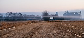
Smithland is a city in Woodbury County, Iowa, United States. It is part of the Sioux City, IA–NE–SD Metropolitan Statistical Area. The population was 181 at the time of the 2020 census.

<span class="mw-page-title-main">Dundee Township, Michigan</span> Civil township in Michigan, United States

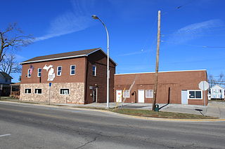
Dundee Township is a civil township of Monroe County in the U.S. state of Michigan. The population was 8,145 at the 2020 census, up from 6,759 in 2010. The township contains the village of Dundee, and the majority of the township is served by Dundee Community Schools.

<span class="mw-page-title-main">Belton, Missouri</span> City in Missouri, United States

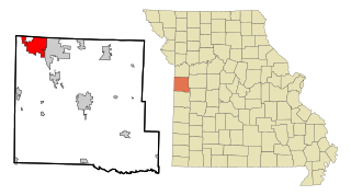
Belton is a city in northwestern Cass County, Missouri, United States. The population was 23,953 at the 2020 census.

<span class="mw-page-title-main">Linneus, Missouri</span> City in Missouri, United States

Linneus is a small city in Linn County, Missouri, United States. The population was 281 at the 2020 census. It is the county seat of Linn County.

<span class="mw-page-title-main">Madison, Missouri</span> City in Missouri, United States

Madison is a city in Monroe County, Missouri, United States. The population was 515 at the 2020 census.

<span class="mw-page-title-main">Paris, Missouri</span> City in Missouri, United States

Paris is a city and county seat of Monroe County, Missouri, United States. The population was 1,161 at the 2020 census.

<span class="mw-page-title-main">Stoutsville, Missouri</span> Village in Missouri, United States

Stoutsville is a village in Monroe County, Missouri, United States. The population was 37 at the 2020 census.

<span class="mw-page-title-main">Green Ridge, Missouri</span> City in Missouri, United States

Green Ridge is a city located along Route 127 in Pettis County, Missouri, United States. The population was 476 at the 2010 census.

<span class="mw-page-title-main">Pleasant Hope, Missouri</span> City in Missouri, United States

Pleasant Hope is a city in Polk County, Missouri, United States. The population was 614 at the 2010 census. It is part of the Springfield, Missouri Metropolitan Statistical Area.

<span class="mw-page-title-main">Nelson, Missouri</span> City in Missouri, United States

Nelson is a city in Saline County, Missouri, United States. The population was 152 at the 2020 census.

<span class="mw-page-title-main">Hunnewell, Missouri</span> City in Missouri, United States

Hunnewell is a city in southeastern Shelby County, Missouri, United States. The population was 139 at the 2020 census.

<span class="mw-page-title-main">Flordell Hills, Missouri</span> City in Missouri, United States

Flordell Hills is a city in St. Louis County, Missouri, United States. The population was 822 at the 2010 census.

<span class="mw-page-title-main">Lakeshire, Missouri</span> City in Missouri, United States

Lakeshire is a city in St. Louis County, Missouri, United States. The population was 1,432 at the 2010 census.

<span class="mw-page-title-main">Clarkson Valley, Missouri</span> City in Missouri, United States

Clarkson Valley is a city in St. Louis County, Missouri, United States. The population was 2,609 at the 2020 census.

<span class="mw-page-title-main">Moline Acres, Missouri</span> City in Missouri, United States

Moline Acres is a city in St. Louis County, Missouri, United States. The population was 2,442 at the 2010 census.

<span class="mw-page-title-main">Warson Woods, Missouri</span> City in Missouri, United States

Warson Woods is a city in St. Louis County, Missouri, United States. The population was 1,962 at the 2010 census.

<span class="mw-page-title-main">Olanta, South Carolina</span> Town in South Carolina, United States

Olanta is a town in Florence County, South Carolina, United States. The population was 563 at the 2010 census, down from 613 in 2000. It is part of the Florence Metropolitan Statistical Area.

<span class="mw-page-title-main">Monroe City, Missouri</span> City in Missouri, United States

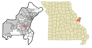
Monroe City is a city in Marion, Monroe, and Ralls counties in the U.S. state of Missouri. The population was 2,652 at the 2020 census.

References

  1. "ArcGIS REST Services Directory". United States Census Bureau. Retrieved August 28, 2022.
  2. 1 2 U.S. Geological Survey Geographic Names Information System: Old Monroe, Missouri
  3. 1 2 "U.S. Census website". United States Census Bureau . Retrieved January 31, 2008.
  4. Fort Howard
  5. Eaton, David Wolfe (1916). How Missouri Counties, Towns and Streams Were Named. The State Historical Society of Missouri. pp.  187.
  6. "Lincoln County Place Names, 1928–1945 (archived)". The State Historical Society of Missouri. Archived from the original on June 24, 2016. Retrieved October 26, 2016.{{cite web}}: CS1 maint: bot: original URL status unknown (link)
  7. "Black Hawk: Resisting American Expansion". Archived from the original on October 4, 2018. Retrieved April 23, 2020.
  8. "Ramsay Place Names File | the State Historical Society of Missouri".
  9. "US Gazetteer files: 2010, 2000, and 1990". United States Census Bureau. February 12, 2011. Retrieved April 23, 2011.
  10. "US Gazetteer files 2010". United States Census Bureau. Archived from the original on July 2, 2012. Retrieved July 8, 2012.
  11. "Census of Population and Housing". Census.gov. Retrieved June 4, 2015.
  12. "U.S. Census website". United States Census Bureau . Retrieved July 8, 2012.