
Merrill C. Meigs Field Airport was a single-runway airport in Chicago that was in operation from 1948 to 2003, when it was bulldozed overnight by then-mayor Richard M. Daley. The airport was located on Northerly Island, an artificial peninsula on Lake Michigan adjacent to downtown Chicago, the second-largest business district in the Western Hemisphere. By 1955, Meigs Field had become the busiest single-strip airport in the United States. The airport was a familiar sight on the downtown lakefront. The latest air traffic tower was built in 1952, and the terminal was dedicated in 1961. The airfield was named for Merrill C. Meigs.

Des Plaines is a city in Cook County, Illinois, United States. Per the 2020 census, the population was 60,675. The city is a suburb of Chicago and is located just north of O'Hare International Airport. It is situated on and is named after the Des Plaines River, which runs through the city just east of its downtown area.

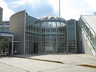
Chicago O'Hare International Airport is a major international airport serving Chicago, Illinois, located on the city's Northwest Side, approximately 17 miles (27 km) northwest of the Loop business district. Operated by the Chicago Department of Aviation and covering 7,627 acres (3,087 ha), O'Hare has non-stop flights to 214 destinations in North America, South America, the Caribbean, Europe, Africa, Asia, the Middle East, Oceania, and the North Atlantic region as of November 2022. As of 2023, O'Hare is considered the world's most connected airport. It is also U.S.A.'s 4th busiest airport, and 7th biggest airport.

The Blue Line is a 26.93-mile-long (43.34 km) Chicago "L" line which extends through The Loop from O'Hare International Airport at the far northwest end of the city, through downtown via the Milwaukee–Dearborn subway and across the West Side to its southwest end at Forest Park, with a total of 33 stations. At about 27 miles, it is the longest line on the Chicago "L" system and second busiest, and one of the longest local subway/elevated lines in the world. It has an average of 64,978 passengers boarding each weekday in 2022.

Illinois Route 19 is a major east–west arterial state highway in northeastern Illinois, United States. It runs from Illinois Route 25 in Elgin, to Lake Shore Drive on the north side of Chicago. Illinois 19 is 33.64 miles (54.14 km) long. For much of its length, it is also known as Irving Park Road and Chicago-Elgin Road.

Illinois Route 72 is an east–west state highway in northern Illinois. It runs from the intersection with Illinois Route 73 north of Lanark east to Illinois Route 43 in Chicago. This is a distance of 110.71 miles (178.2 km).

Illinois Route 171 (IL 171) is a 38.61-mile-long (62.14 km) north–south state highway in northeastern Illinois. It runs from U.S. Route 6 (US 6) in Joliet north to Illinois Route 72 at the Chicago–Park Ridge border. The section of IL 171 on Archer Avenue from Joliet to Summit is historically significant, originating as a Native American trail, and later serving for a time as part of the first numbered highway between St. Louis and Chicago.
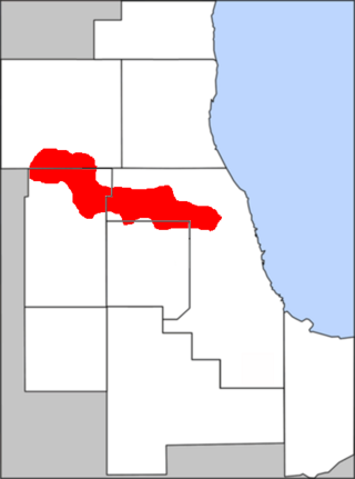
O'Hare, located on the far north side of Chicago, is one of the city's 77 community areas. O'Hare International Airport is located within the boundaries of this community area. This community area is the only one that extends outside Cook County; the western edge is in DuPage County.

Palm Springs International Airport, formerly Palm Springs Municipal Airport, is an airport two miles east of downtown Palm Springs, California, United States. The airport covers 940 acres and has two runways. The facility operates year-round, with most flights occurring in the fall, winter, and spring.

U.S. Route 12 (US 12) in the U.S. state of Illinois is an arterial highway that runs northwest to southeast through the Chicago metropolitan area. It enters Illinois at the Wisconsin border north of Richmond, and exits into Hammond, Indiana, from Chicago near the foot of the onramp to the Indiana Toll Road ; as it exits Illinois, the route is also concurrent with US 20 and US 41. Within Illinois, US 12 runs for a distance of 85.14 miles (137.02 km).

Willard was an unincorporated community located in what is now a part of Washington Dulles International Airport in the U.S. state of Virginia.
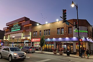
Devon Avenue is a major east-west street in the Chicago metropolitan area. It begins at Chicago's Sheridan Road, which borders Lake Michigan, and it runs west until merging with Higgins Road near O'Hare International Airport. Devon continues on the opposite side of the airport and runs intermittently through Chicago's northwestern suburbs. In the northwest suburbs west of O'Hare Airport, Devon Avenue is the boundary between Cook and DuPage counties. The street is located at 6400 N in Chicago's address system.
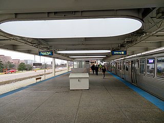
Rosemont, formerly River Road, is a Chicago "L" station at the intersection of River Road and I-190 in the suburb of Rosemont, Illinois. It is located in the median of I-190 with one island platform serving two tracks, 16 miles (26 km) northwest of The Loop. Trains are scheduled to depart from Rosemont every 2–7 minutes during rush-hour periods, and take about 36 minutes to travel to the Loop. The station is 7 blocks east and 2 blocks north of O'Hare International Airport. Rosemont is the busiest station outside the city limits of Chicago, with 2,090,977 passenger entries in 2014.
Cumberland is a station on the Chicago Transit Authority's 'L' system. Situated on the Blue Line between Rosemont and Harlem, the station is located in the median of the Kennedy Expressway at Cumberland Avenue in the O'Hare community area on Chicago's Northwest Side. It is also in close proximity to both the Norwood Park neighborhood and the city of Park Ridge as well as the village of Norridge. The area surrounding the station consists of mixed commercial and residential development.
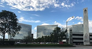
The Golden Corridor is the area around the Jane Addams Memorial Tollway, formerly known as the Northwest Tollway, in the Chicago metropolitan area. Its name refers to the "gold" mine of economic profit for communities in the area. Several Fortune 500 company headquarters, office parks, industrial parks, exhibition and entertainment centers, medical facilities, hotels, shopping centers, and restaurants are in the Golden Corridor. With the exception of the O'Hare area of Chicago, all the communities in this region are part of a larger region known as the "Northwest Suburbs".

Schaumburg Regional Airport is a public use airport located 22 nautical miles northwest of Chicago in the village of Schaumburg in Cook and DuPage counties, Illinois, United States. The airport is owned by the Village of Schaumburg and is just south of the Schaumburg Municipal Helistop.

Purdue University Airport is a public-use airport in Tippecanoe County, Indiana, United States. Owned by Purdue University, the airport is 2 nautical miles southwest of the central business district of Lafayette, Indiana, in West Lafayette. Because of the heavy traffic generated by Purdue University and its flight programs, Purdue University Airport is one of the busiest airports in Indiana, second only to the Indianapolis International Airport. The airport is also served by Southern Airways Express, with daily passenger flights to Chicago–O'Hare.

U.S. Route 45 in the state of Illinois is a major north–south U.S. Highway that runs from the Brookport Bridge over the Ohio River at Brookport north through rural sections of eastern Illinois and then through the suburbs of Chicago to the Wisconsin state line east of Antioch. This is a distance of 428.99 miles (690.39 km). US 45 is the longest numbered route in Illinois.

Mannheim Road, also known as La Grange Road from Cermak Road to U.S. Route 30, is a north–south major street in the near-western suburbs of Chicago. It carries US 12 from Des Plaines to 95th St near Hickory Hills, US 45 between Des Plaines on southwards past Frankfort, Illinois and carries US 20 between Lake Street in Stone Park, Illinois and 95th St. near Hickory Hills.

The Great West Aerodrome, also known as Harmondsworth Aerodrome or Heathrow Aerodrome, was a grass airfield, operational between 1930 and 1944. It was on the southeast edge of the hamlet of Heathrow, in the parish of Harmondsworth. The Fairey Aviation Company owned and operated it, for assembly and flight testing of Fairey-manufactured aircraft. The area was to later be the site of London Heathrow Airport.
