Caldecote is a tiny hamlet in the civil parish of Moulsoe in the City of Milton Keynes, Buckinghamshire, England.
Major-General William Roy was a Scottish military engineer, surveyor, and antiquarian. He was an innovator who applied new scientific discoveries and newly emerging technologies to the accurate geodetic mapping of Great Britain. His masterpiece is usually referred to as Roy's Map of Scotland.

The Lincolnshire Wolds are a range of low hills in the county of Lincolnshire, England which run roughly parallel with the North Sea coast, from the Humber Estuary in the north-west to the edge of the Lincolnshire Fens in the south-east. They are a designated Area of Outstanding Natural Beauty (AONB), and the highest area of land in eastern England between Yorkshire and Kent.

The Royal Commission on the Ancient and Historical Monuments of Wales, established in 1908, is a Welsh Government sponsored body concerned with some aspects of the archaeological, architectural and historic environment of Wales. It is based in Aberystwyth.

Heritage Documentation Programs (HDP) is a division of the U.S. National Park Service (NPS) responsible for administering the Historic American Buildings Survey (HABS), Historic American Engineering Record (HAER), and Historic American Landscapes Survey (HALS). These programs were established to document historic places in the United States. Records consist of measured drawings, archival photographs, and written reports, and are archived in the Prints and Photographs Division of the Library of Congress.

Ordnance Survey Ireland was the national mapping agency of Ireland. It was established on 4 March 2002 as a body corporate. It was the successor to the former Ordnance Survey of Ireland. It and the Ordnance Survey of Northern Ireland (OSNI) were themselves the successors to the Irish operations of the British Ordnance Survey. OSI was part of the Irish public service. OSI was headquartered at Mountjoy House in the Phoenix Park in Dublin, which had previously been the headquarters of the British Ordnance Survey in Ireland until 1922.

William George Hoskins was an English local historian who founded the first university department of English Local History. His great contribution to the study of history was in the field of landscape history.
John Rocque was a French-born British surveyor and cartographer, best known for his detailed map of London published in 1746.
The Gazetteer for Scotland is a gazetteer covering the geography, history and people of Scotland. It was conceived in 1995 by Bruce Gittings of the University of Edinburgh and David Munro of the Royal Scottish Geographical Society, and contains 25,870 entries as of July 2019. It claims to be "the largest dedicated Scottish resource created for the web". The Gazetteer for Scotland provides a carefully researched and editorially validated resource widely used by students, researchers, tourists and family historians with interests in Scotland.
The Great Britain Historical GIS is a spatially enabled database that documents and visualises the changing human geography of the British Isles, although is primarily focussed on the subdivisions of the United Kingdom mainly over the 200 years since the first census in 1801. The project is currently based at the University of Portsmouth, and is the provider of the website A Vision of Britain through Time.

The term tithe map is usually applied to a map of an English or Welsh parish or township, prepared following the Tithe Commutation Act 1836. This act allowed tithes to be paid in cash rather than goods. The map and its accompanying schedule gave the names of all owners and occupiers of land in the parish. Individual tithe owners sometimes prepared maps for their own use to show who owned what land. These maps are sometimes also called tithe maps, although such maps are not common before 1836.

Ordnance Survey (OS) is the national mapping agency for Great Britain. The agency's name indicates its original military purpose, which was to map Scotland in the wake of the Jacobite rising of 1745. There was also a more general and nationwide need in light of the potential threat of invasion during the Napoleonic Wars. Since 1 April 2015, Ordnance Survey has operated as Ordnance Survey Ltd, a government-owned company, 100% in public ownership. The Ordnance Survey Board remains accountable to the Secretary of State for Science, Innovation and Technology. It was also a member of the Public Data Group.
The Neath Disturbance is a geological structure which stretches across south Wales from Swansea Bay northeastwards as far as Hereford in western England. It consists of a series of both faults and associated folds which were active during the mountain-building period known as the Variscan orogeny. This line of weakness probably featured in the earlier Caledonian Orogeny and perhaps reflects a more ancient line of weakness in the basement rocks.
(John) Brian Harley was a geographer, cartographer, and map historian at the universities of Birmingham, Liverpool, Exeter and Wisconsin–Milwaukee. He helped found the History of Cartography Project and was the founding co-editor of the resulting The History of Cartography. In recent years, Harley's work has gained broad prominence among geographers and social theorists, and it has contributed greatly to the emerging discipline of critical cartography.
Colonel Robert Kearsley Dawson was an English surveyor and cartographer of the Corps of Royal Engineers.
The Yorkshire Electric Tramways operated two separate tramway services. One in Wakefield between 1904 and 1932, and the other between Normanton, Pontefract and Castleford between 1906 and 1932

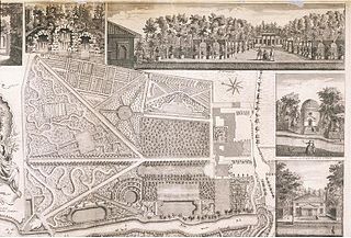
Bordesley Hall was an 18th century manor house near Bordesley, Birmingham, which stood in a 15 hectare park south of the Coventry Road in an area between what is now Small Heath and Sparkbrook. The Georgian house was the successor to an earlier medieval moated manor.
The Ordnance Survey Great Britain County Series maps were produced from the 1840s to the 1890s by the Ordnance Survey, with revisions published until the 1940s. The series mapped the counties of Great Britain at both a six inch and twenty-five inch scale with accompanying acreage and land use information. Following the introduction of the Ordnance Survey National Grid in the 1930s the County Series maps were replaced by a new series of maps at each scale.

The River Lerryn is a river in east Cornwall, England, UK, a tributary of the River Fowey. The Lerryn is the largest of the tributaries which enter the estuary of the Fowey. The river is tidal up to the village of Lerryn. The landscape of the Lerryn catchment is rural and includes heathland, moorland and rough pasture in the upper reaches and broadleaf, coniferous and mixed plantation woodland in the lower. This catchment includes four SSSIs, including Redlake Meadows & Hoggs Moor. The Lerryn rises at Fairy Cross on the southern slopes of Bodmin Moor and flows south-southwest until it enters the Fowey estuary.
Gerald Sedgewick Wilkinson, was a British illustrator, art historian, naturalist, photographer, artist and book-designer, known for his books on J. M. W. Turner's sketches and on British trees and woodlands. Though there had been many sections on the genus Ulmus in books and journals, Wilkinson's monograph, Epitaph for the Elm (1978), written for the general reader and illustrated in colour, was the first such book to be published in the UK.
