Converse County is a county located in the U.S. state of Wyoming. As of the 2020 United States Census, the population was 13,751. Its county seat is Douglas.

Golden Valley is an unincorporated area and census-designated place (CDP) in Mohave County, Arizona, United States. The population was 8,801 at the 2020 census.
Gages Lake is a census-designated place (CDP) in Warren Township, Lake County, Illinois, United States. The population was 10,637 at the 2020 census.

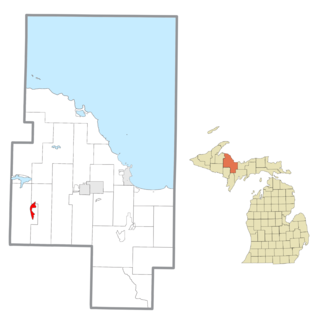
Quinnesec is an unincorporated community in Dickinson County in the U.S. state of Michigan. It is a census-designated place (CDP) for statistical purposes and has no legally recognized status as a municipality. The population was 1,191 at the 2010 census. It is part of the Iron Mountain, MI–WI Micropolitan Statistical Area.

Michigamme is an unincorporated community in Marquette County in the U.S. state of Michigan. It is located within Michigamme Township on the north shores of Lake Michigamme. For statistical purposes, the United States Census Bureau has defined Michigamme as a census-designated place (CDP). The CDP had a population of 255 at the 2020 census.
Republic is an unincorporated community in Marquette County in the U.S. state of Michigan. It is also a census-designated place (CDP) for statistical purposes and no legal status as an incorporated municipality. The CDP had a population of 470 at the 2020 census. The community is located mostly within Republic Township with a small portion extending north into Humboldt Township.

Belfry is a census-designated place (CDP) in Carbon County, Montana, United States. It is part of the Billings, Montana Metropolitan Statistical Area. The population was 218 at the 2010 census. It is located approximately 11 miles (18 km) from the Wyoming border, roughly halfway between Billings, Montana and Cody, Wyoming.

Joplin is a unincorporated community and census-designated place (CDP) in Liberty County, Montana, United States. The population was 157 at the 2010 census.

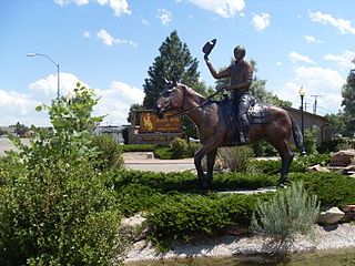
Douglas is a city in Converse County, Wyoming, United States. The population was 6,120 at the 2010 census. It is the county seat of Converse County and the home of the Wyoming State Fair.

Esterbrook is a village, and the locus of a same-named census-designated place (CDP), in Converse County, Wyoming, United States in the Medicine Bow National Forest. The population was 52 at the 2010 census.

Jeffrey City is a former uranium mining boomtown located in Fremont County, in the central part of the U.S. state of Wyoming. The town is known in Wyoming and the American West as symbol of a boomtown that went "bust" very quickly, as the mine was shut down in 1982 and over 95% of the inhabitants left the town within three years. The population was 58 at the 2010 census, far lower than its onetime population of several thousand people. For statistical purposes, the United States Census Bureau has defined Jeffrey City as a census-designated place (CDP).
Powder River is a census-designated place (CDP) in Natrona County, Wyoming, United States. It is part of the Casper, Wyoming Metropolitan Statistical Area. The population was 30 in the 2020 census and 44 in the 2010 census.

Point of Rocks is an unincorporated community in Sweetwater County, Wyoming, United States. As of the 2000 census, Point of Rocks had a total population of three, when it was a census-designated place (CDP).
Leola is a census-designated place (CDP) in Lancaster County, Pennsylvania, United States. It includes the unincorporated communities of Leola, Leacock, and Bareville, and prior to 2010 was known as the Leacock-Leola-Bareville census-designated place. Originally named "Mechanicsburg", its present name is a portmanteau of "Leacock" and the "Glenola" train station that once served the town. As of the 2010 census, the population of the CDP was 7,214.
Brownstown is an unincorporated community and census-designated place (CDP) in West Earl Township, Lancaster County, Pennsylvania, United States. As of the 2010 census, the population was 2,816.
Amasa is an unincorporated community and census-designated place (CDP) in Iron County in the U.S. state of Michigan. The population of the CDP was 195 at the 2020 census. The community is located within Hematite Township.

Watersmeet is an unincorporated community and census-designated place (CDP) in Watersmeet Township, Michigan. As of the 2010 census, the CDP had a population of 428, out of a total population in the township of 1,417. The community was platted in 1884, designated as a station of the Milwaukee Lake Shore and Western Railroad.

Fairfax Station is a census-designated place (CDP) in Fairfax County, Virginia, United States. The population was 12,030 at the 2010 census. Located in Northern Virginia, its center is located 22 miles (35 km) southwest of Washington, D.C.

Refton is an unincorporated community and census-designated place (CDP) in Strasburg Township, Lancaster County, Pennsylvania, United States, with a ZIP code of 17560. The community is located along U.S. Route 222. As of the 2010 census, the population was 298.
Irvington is an unincorporated community and census-designated place (CDP) in Irvington Township, Kossuth County, Iowa, United States. As of the 2010 census it had a population of 38.

