
Guam is an organized, unincorporated territory of the United States in the Micronesia subregion of the western Pacific Ocean. Guam's capital is Hagåtña, and the most populous village is Dededo. It is the westernmost point and territory of the United States, reckoned from the geographic center of the U.S.. In Oceania, Guam is the largest and southernmost of the Mariana Islands and the largest island in Micronesia.
The history of Guam starts with the early arrival around 2000 BC of Austronesian people ent American rule of the island began with the 1898 Spanish–American War. Guam's history of colonialism is the longest among the Pacific islands.

Guam is a U.S. territory in the western Pacific Ocean, at the boundary of the Philippine Sea. It is the southernmost and largest member of the Mariana Islands archipelago, which is itself the northernmost group of islands in Micronesia. The closest political entity is the Commonwealth of the Northern Mariana Islands (CNMI), another U.S. territory. Guam shares maritime boundaries with CNMI to the north and the Federated States of Micronesia to the south. It is located approximately one quarter of the way from the Philippines to Hawaii. Its location and size make it strategically important. It is the only island with both a protected harbor and land for multiple airports between Asia and Hawaii, on an east–west axis, and between Papua New Guinea and Japan, on a north–south axis.

The Northern Mariana Islands, officially the Commonwealth of the Northern Mariana Islands, is an unincorporated territory and commonwealth of the United States consisting of 14 islands in the northwestern Pacific Ocean. The CNMI includes the 14 northernmost islands in the Mariana Archipelago; the southernmost island, Guam, is a separate U.S. territory. The Northern Mariana Islands were listed by the United Nations as a non-self governing territory until 1990.

Hagåtña is the capital village of the United States territory of Guam. From the 18th through mid-20th century, it was Guam's population center, but today it is the second smallest of the island's 19 villages in both area and population. However, it remains one of the island's major commercial districts in addition to being the seat of government.

Apra Harbor, also called Port Apra, is a deep-water port on the western side of the United States territory of Guam. It is considered one of the best natural ports in the Pacific Ocean. The harbor is bounded by Cabras Island and the Glass Breakwater to the north and the Orote Peninsula in the south. Naval Base Guam and the Port of Guam are the two major users of the harbor. It is also a popular recreation area for boaters, surfers, scuba divers, and other recreationalists.

The Chamorro people are the indigenous people of the Mariana Islands, politically divided between the United States territory of Guam and the encompassing Commonwealth of the Northern Mariana Islands in Micronesia. Today, significant Chamorro populations also exist in several U.S. states, including Hawaii, California, Washington, Texas, Tennessee, Oregon, and Nevada, all of which together are designated as Pacific Islander Americans according to the U.S. Census. According to the 2000 Census, about 64,590 people of Chamorro ancestry live in Guam and another 19,000 live in the Northern Marianas.

The United States territory of Guam is divided into nineteen municipalities, called villages. Each village is governed by an elected mayor. Village populations range in size from under 1,000 to over 40,000. In the 2020 census, the total population of Guam was 153,836. Each village is counted as a county equivalent by the United States Census Bureau for statistical purposes.
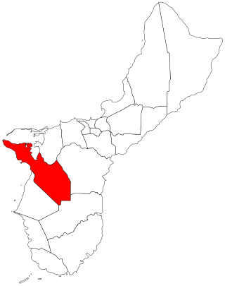
Sånta Rita-Sumai, formerly Santa Rita and encompassing the former municipality of Sumay, is a village located on the southwest coast of the United States territory of Guam with hills overlooking Apra Harbor. According to the 2020 census it has a population of 6,470, which is up slightly from 6,084 in 2010 but down from 11,857 in 1990. Santa Rita is the newest village in Guam, having been established after the Second World War.

Piti is a village located on the central west coast of the United States territory of Guam. It contains northern and eastern coastlines of Apra Harbor, including Cabras Island, which has the commercial Port of Guam and the island's largest power plants. Piti was a pre-Spanish CHamoru village and, after Spanish colonization, became the primary port town on Guam. The town was largely destroyed during the 1944 liberation of Guam and the population relocated during the wartime construction of Apra Harbor.
John Clipperton was an English privateer who fought against the Spanish in the 18th century. He was involved in two buccaneering expeditions to the South Pacific—the first led by William Dampier in 1703, and the second under his own command in 1719. He used Clipperton Island in the eastern Pacific Ocean as a base for his raids.

The Battle of Guam was an engagement during the Pacific War in World War II, and took place from 8 December to 10 December 1941 on Guam in the Mariana Islands between Japan and the United States. The American garrison was defeated by Japanese forces on 10 December, which resulted in an occupation until the Second Battle of Guam in 1944.

Orote Field is a former air base in the United States territory of Guam built by the Empire of Japan with Chamorro forced labor during the Japanese occupation of Guam (1941-1944). It is separate from the Marine Corps amphibious airplane base at located at Sumay village that was operational from 1921 to 1931. Following the liberation of Guam in 1944, the U.S. military repaired the field for further use in the Pacific War.

Carolinians are a Micronesian ethnic group who originated in Oceania, in the Caroline Islands, with a total population of over 8,500 people. They are also known as Remathau in the Yap's outer islands. The Carolinian word means "People of the Deep Sea." It is thought that their ancestors may have originally immigrated from Asia and Indonesia to Micronesia around 2,000 years ago. Their primary language is Carolinian, called Refaluwasch by native speakers, which has a total of about 5,700 speakers. The Carolinians have a matriarchal society in which respect is a very important factor in their daily lives, especially toward the matriarchs. Most Carolinians are of the Roman Catholic faith.
The Spanish–Chamorro Wars, also known as the Chamorro Wars and the Spanish–Chamorro War, refer to the late seventeenth century unrest among the Chamorros of the Mariana Islands in the western Pacific Ocean against the colonial effort of Habsburg Spain. Anger at proselytizing by the first permanent mission to Guam, which was led by Diego Luis de San Vitores, and a series of cultural misunderstandings led to increasing unrest on Guam and a Chamorro siege of the Hagåtña presidio incited by maga'låhi (Chief) Hurao in 1670. Maga'låhi Matå'pang killed San Vitores in 1672, resulting in a campaign of Spanish reprisal burnings of villages through 1676. Local anger at the attacks against villages resulted in another open rebellion led by Agualin and a second siege of Hagåtña. Governor Juan Antonio de Salas conducted a counter-insurgency campaign that successfully created a system of collaboration in which Guamanians turned in rebels and murderers and transferred most of the people from about 180 villages to seven towns, a policy known as reducción. By the early 1680s, Guam was largely "reduced," or pacified.

Sumay, also Sumai, was a village on the United States territory of Guam. It was located on the north coast of the Orote Peninsula along Apra Harbor. It was inhabited by Chamorro people before contact with Europeans. Sumay became a prosperous port town serving whalers and other sailors in the 1800s and the second most populous settlement on Guam after Hagåtña, the capital of the Spanish Mariana Islands. Following the Capture of Guam by the United States in 1898, the village was the site of Marine Barracks Guam. In the early 1900s, it was a link for two firsts connecting the United States and Asia: the first submarine communications cable for telegraph and the China Clipper, the first air service. After the Japanese invasion of Guam in 1941, the residents were evicted and the village turned into a Japanese military garrison. Sumay was leveled during the U.S. liberation of the island in 1944. The U.S. military prohibited the residents from returning, relocating them to the hills of nearby Sånta Rita-Sumai. In 1948, the U.S. military exercised eminent domain and took all private and commercial property at Sumay. Its former location is now on Naval Base Guam.

Liberation Day on the U.S. territory of Guam is an annual commemoration of the invasion by U.S. military forces on July 21, 1944, which ended the Japanese occupation that had begun in 1941. Begun in 1945, it is Guam's largest celebration. Festivities include a queen contest, summer carnival, fireworks display, and mile-long parade on Marine Corps Drive in Hagåtña from Adelup to Paseo de Susana, as well as solemn memorials and visits to massacre sites. It is organized by the Guam Island Fair Committee.

Radio Barrigada, formally Communications Site Barrigada and previously Communications Annex Barrigada, refers to two adjacent U.S. military transmitter facilities located in the villages of Barrigada and Mangilao on the western Pacific territory of Guam. The larger facility is Naval Computer and Telecommunications Site (NCTS) Barrigada, operated by Naval Base Guam, located entirely within Barrigada.
Agualin, sometimes Aguarin or Diego de Aguarin, was a CHamoru chief who led a siege of Hagåtña (1676–1677) on Guam during the Spanish-Chamorro Wars. This was the second of three unsuccessful sieges of the Spanish presidio carried out by CHamorus seeking to eject the colonial presence, with the final widespread violence on Guam in 1683. While Spanish colonial history vilified Agualin as being anti-Christian and anti-civilization, a modern reevaluation reframes Agualin as a champion of CHamoru nationalism.
An epidemic of smallpox in 1856 on the west Pacific island of Guam, then under the control of Spain, resulted in the death of over half of the population, or about 4,500 people. The population collapse led Spanish authorities to transfer the population of Pago to Hagåtña, ending a settlement dating back before colonization. It also led the Governor of the Spanish Mariana Islands to encourage immigration to Guam.


