
Golden Horn is an 8,366-foot (2,550-metre) mountain summit located in Okanogan County in Washington state. It is part of the Okanogan Range which is a sub-range of the North Cascades Range. Golden Horn is situated north of Methow Pass at headwaters of the Methow River, on land administered by the Okanogan–Wenatchee National Forest. It ranks as the 95th-highest summit in Washington. The nearest higher peak is Tower Mountain, 1.67 miles (2.69 km) to the southeast. The first ascent of Golden Horn was made by Fred Beckey, Keith Rankin, and Charles Welsh on September 18, 1946.

Mount Hardy is an 8,080+ ft mountain summit located on the common border of Okanogan County with Skagit County in Washington state. It is part of the Okanogan Range which is a sub-range of the North Cascades Range. Mount Hardy is situated west of Methow Pass, at headwaters of the Methow River, on land administered by the Okanogan–Wenatchee National Forest. The nearest higher peak is Golden Horn, 1.75 miles (2.82 km) to the northeast. Mount Hardy can be seen from the North Cascades Highway which traverses below the southwestern base of the mountain. This mountain's name was officially adopted in 1973 by the United States Board on Geographic Names.

Azurite Peak is an 8,400-foot (2,600-metre) double-summit mountain located at the common boundary point of Okanogan County, Skagit County, and Whatcom County in Washington state. It is part of the Okanogan Range which is a sub-range of the North Cascades Range. Azurite Peak is situated north of Azurite Pass on land administered by the Okanogan–Wenatchee National Forest. The nearest higher neighbor is Tower Mountain, 5.24 miles (8.43 km) to the south-southeast, and Mount Ballard lies 1.97 miles (3.17 km) to the north. Remnants of a small pocket glacier are found on the east aspect. The Pacific Crest Trail traverses the base of Azurite Peak.
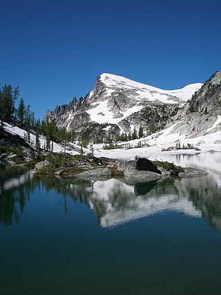
Little Annapurna is an 8,440+ ft granite summit located in Chelan County of Washington state. The origin of the name came from the Sherpa Climbing Club of Ellensburg, and is inspired by the obvious resemblance to its Himalayan namesake when comparing the south faces of both. Little Annapurna is part of The Enchantments within the Alpine Lakes Wilderness, and is set on land managed by the Okanogan–Wenatchee National Forest. It belongs to the Stuart Range which is subset of the Cascade Range. Little Annapurna is situated southeast of Dragontail Peak, which is its nearest higher neighbor. Remnants of the receding Snow Creek Glacier can be found on its gentle north slope. Precipitation runoff drains into tributaries of the Wenatchee River.

Holliway Mountain is an 8000+ ft granite summit located in Okanogan County in Washington state. It is part of the Okanogan Range which is a sub-range of the North Cascades Range. Holliway Mountain is situated near the headwaters of the Methow River on land administered by the Okanogan–Wenatchee National Forest. The nearest higher peak is Golden Horn, 0.91 miles (1.46 km) to the south. Azurite Peak is located three miles to the north-northwest.

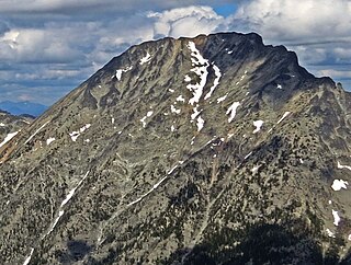
Cashmere Mountain is an 8,501-foot (2,591-metre) mountain summit located in Chelan County of Washington state. Cashmere Mountain is situated within the Alpine Lakes Wilderness, on land managed by the Okanogan–Wenatchee National Forest. It is part of the Wenatchee Mountains which are subset of the Cascade Range. Its nearest higher neighbor is Cannon Mountain, 4.4 mi (7.1 km) to the southeast. Precipitation runoff from this mountain drains into tributaries of Icicle Creek, which in turn is a tributary of the Wenatchee River.

Mount Ballard is an 8,340-foot (2,540-metre) mountain summit located in eastern Whatcom County in Washington state. It is part of the Okanogan Range which is a sub-range of the North Cascades Range, and the mountain is situated on land administered by the Okanogan–Wenatchee National Forest. Ballard ranks 88th on Washington's highest 100 peaks. The nearest higher neighbor is Azurite Peak, 2.04 miles (3.28 km) to the south. Precipitation runoff from Mount Ballard drains into Mill Creek and Slate Creek, both tributaries of the Skagit River.

Monument Peak is an 8,597-foot (2,620-metre) mountain summit located in western Okanogan County in Washington state. It is part of the Okanogan Range which is a sub-range of the North Cascades. The mountain is situated in the Pasayten Wilderness, on land administered by the Okanogan–Wenatchee National Forest. The nearest higher peak is Mount Lago, 2.42 miles (3.89 km) to the north. Precipitation runoff from Monument Peak drains east into Monument Creek, and west into Eureka Creek, which are both part of the Methow River drainage basin.

Cathedral Peak is an 8,606-foot (2,623-metre) mountain summit located in Okanogan County in Washington state. It is part of the Okanogan Range which is a sub-range of the North Cascades. The mountain is situated in the Pasayten Wilderness, on land administered by the Okanogan–Wenatchee National Forest. The nearest higher peak is Grimface Mountain, 2.6 miles (4.2 km) to the north in Cathedral Provincial Park in Canada. The Pacific Northwest Trail traverses below the south slope of Cathedral Peak as it crosses Cathedral Pass. Less than a mile to the opposite side of the pass stands Amphitheater Mountain. Precipitation runoff from Cathedral Peak drains west into Cathedral Fork, or east into Cathedral Creek.

Slate Peak is a 7,440-foot (2,270-metre) mountain summit located on the shared border between Okanogan County and Whatcom County in Washington state. It is part of the Okanogan Range, which is a sub-range of the North Cascades. The mountain is situated 15 miles (24 km) northwest of Mazama, on the boundary line of the Pasayten Wilderness, on land managed by the Okanogan–Wenatchee National Forest. The peak has the distinction of having the highest road in Washington, as well as the highest fire lookout. Although the narrow one-lane white-knuckle road reaches the summit of the mountain, the Forest Service gated it to vehicles, which necessitates walking the final few hundred yards. Additionally, the Pacific Crest Trail traverses the west slope of the peak, and the West Fork Pasayten Trail traverses the eastern slope. The nearest higher peak is Devils Peak, 2.57 miles (4.14 km) to the north. Precipitation runoff from Slate Peak drains east into Pasayten River, or west into Slate Creek, which is in the Skagit River drainage basin.

Windy Peak is an 8,333-foot (2,540-metre) mountain summit located in Okanogan County in Washington state. It is part of the Okanogan Range which is a sub-range of the North Cascades and Cascade Range. The mountain is situated 5 miles (8.0 km) south of the Canada–United States border, on the east side of the Cascade crest, in the Pasayten Wilderness, on land managed by the Okanogan–Wenatchee National Forest. The nearest higher peak is Haystack Mountain, 9.24 miles (14.87 km) to the northwest in Canada. Precipitation runoff from Windy Peak drains into tributaries of the Methow River and Similkameen River.
Mount Lago is a prominent 8,745-foot (2,665-metre) mountain summit located in the Okanogan Range of the North Cascades, in Okanogan County of Washington state. The mountain is situated on the eastern side of the Cascade crest, in the Pasayten Wilderness, on land managed by the Okanogan–Wenatchee National Forest. The nearest higher peak is Jack Mountain, 19.5 miles (31.4 km) to the west-southwest. Mount Lago is the highest summit of the Okanogan Range, and follows only Jack Mountain {9,075 ft} as the highest peak in the Pasayten Wilderness. Lago is the fourth-most prominent mountain in the Pasayten Wilderness. Precipitation runoff from the mountain drains into tributaries of the Pasayten River and Methow River. The mountain was named for Lage Wernstedt (1878-1959), a Forest Service surveyor who made numerous first ascents of the mountains he was mapping in the North Cascades. Lago, is a play on the way Americans pronounced his name. Lage, pronounced Loggy, had a son named Lago.

Castle Peak is a prominent 8,306-foot (2,532-metre) mountain summit located in the Hozameen Range of the North Cascades, on the shared border between Okanogan County and Whatcom County of Washington state. The mountain is situated 1 mile (1.6 km) south of the Canada–United States border, on the Cascade crest, in the Pasayten Wilderness, on land managed by the Okanogan–Wenatchee National Forest. The nearest higher peak is Jack Mountain, 14.8 miles (23.8 km) to the south-southwest. Castle Peak is the second highest summit of the Hozameen Range following Jack Mountain. Castle Peak is the fifth-most prominent mountain in the Pasaten Wilderness. Precipitation runoff from the mountain drains east into Castle Creek, a tributary of the Similkameen River, or west into tributaries of the Skagit River.
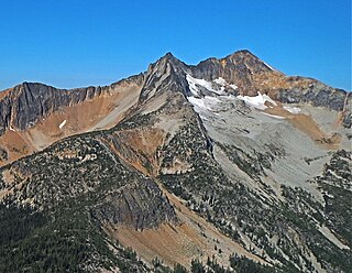
Mount Carru is an 8,595-foot (2,620-metre) mountain summit located in western Okanogan County in Washington state. It is the 7th highest peak of the Okanogan Range, which is a sub-range of the North Cascades. The mountain is situated in the Pasayten Wilderness, on land administered by the Okanogan–Wenatchee National Forest. The nearest higher peak is Mount Lago, 0.8 miles (1.3 km) to the east, and Osceola Peak stands 1 mile (1.6 km) west. The mountain has a steep north face, but the south slope is covered in scree which allows a nontechnical climbing ascent. Precipitation runoff from Mount Carru drains north into Lease Creek which is a tributary of the Pasayten River, or south into Eureka Creek, which is part of the Methow River drainage basin.

Finney Peak is an 8,110-foot (2,470-metre) mountain summit located West of Sawtooth Ridge(The Sawtooths), a sub-range of the North Cascades in Chelan County of Washington state. Finney Peak is situated within the Lake Chelan-Sawtooth Wilderness on land managed by the Okanogan–Wenatchee National Forest. The nearest higher peak is Star Peak, 3 miles (4.8 km) to the northeast. Precipitation runoff from the mountain drains into nearby Lake Chelan via Prince Creek and Cascade Creek.

Switchback Peak is an 8,321-foot (2,536-metre) mountain summit located in the Methow Mountains, a subset of the North Cascades in Washington state. It is the eighth-highest peak in the Methow Mountains, and ranks 95th in the state of Washington. Switchback Peak is set on Sawtooth Ridge, on land managed by the Okanogan-Wenatchee National Forest. Other peaks of Sawtooth Ridge include Oval Peak, Star Peak, Hoodoo Peak, Courtney Peak, Mount Bigelow, and Martin Peak, which is the nearest higher neighbor, 0.96 miles (1.54 km) to the north.

Pasayten Peak is a 7,850-foot (2,390-metre) pyramidal-shaped mountain summit located in western Okanogan County in Washington state. It is part of the Okanogan Range which is a sub-range of the North Cascades. The mountain is situated in the Pasayten Wilderness, on land administered by the Okanogan–Wenatchee National Forest. The nearest higher neighbor is Wildcat Mountain, 3 miles (4.8 km) to the east-southeast, and Slate Peak is set 3.7 miles (6.0 km) to the south. Pasayten Peak is the high point of Gold Ridge, and precipitation runoff from this peak drains into the West and Middle Forks of Pasayten River.

Mount Berge is a 7,960-foot (2,430-metre) double-summit granitic mountain located in the Glacier Peak Wilderness of the North Cascades, in Chelan County of Washington state. The mountain is situated along the crest of the Cascade Range, on land managed by the Okanogan–Wenatchee National Forest. Its nearest higher neighbor is Napeequa Peak, 1.2 mi (1.9 km) to the west, and Buck Mountain is 1.7 mi (2.7 km) to the east-southeast. Berge is positioned on Chiwawa Ridge with Buck and Napeequa, and other notable peaks on this ridge include Fortress Mountain, Brahma Peak, Cirque Mountain, Helmet Butte, and Chiwawa Mountain. Precipitation runoff from Berge drains to the headwaters of Napeequa River; or east into tributaries of the Chiwawa River.

Skagit Peak is a 6,824-foot (2,080-metre) mountain summit located in the North Cascades, in Whatcom County of Washington state. It is situated on the western side of the Cascade crest, at the western edge of the Pasayten Wilderness, on land managed by the Okanogan–Wenatchee National Forest. Skagit Peak is part of the Hozameen Range, a subset of the North Cascades which also includes Hozomeen Mountain to the north, and Jack Mountain to the south. Precipitation runoff from this mountain drains into the Skagit River via Three Fools Creek and Ross Lake.

Big Craggy Peak is a prominent 8,470-foot (2,580-metre) mountain summit located in western Okanogan County in Washington state, USA. It is part of the Okanogan Range which is a sub-range of the North Cascades. This remote mountain is situated 12.5 mi (20.1 km) north-northeast of Mazama, on land administered by the Okanogan–Wenatchee National Forest. Big Craggy has two subsidiary peaks, North Peak (8,205-ft), and West Craggy (8,366-ft), the latter set on the Pasayten Wilderness boundary. The nearest higher peak is Monument Peak, 10 miles (16 km) to the west-northwest. Big Craggy Peak ranks 61st on Washington's highest 100 peaks, and 62nd on the "Bulger List". Precipitation runoff from Big Craggy drains into Eightmile Creek which is a tributary of the Chewuch River.

