Otero Mesa

Last updated
Geologic Map of New Mexico.png
Otero Mesa

Otero Mesa is a plateau in the Trans-Pecos. The plateau extends north from Hudspeth County, Texas into Otero County, New Mexico. [1] Otero Mesa is the dominant landform in Hudspeth County, composing 70% of its land area. [1] [2] Otero Mesa has a more limited extant in Otero County, NM. Overall, 2/3 of Otero Mesa are in Texas, but the colloquial usage of "Otero Mesa" is restricted to the component of the plateau in New Mexico. [1] [3] [4] This is only a political distinction; Otero Mesa is physiographically continuous across the NM-TX state line. [1]

Contents

In the center of Otero Mesa, the plateau is interrupted by the Cornudas Mountains, a cluster of buttes that jut almost 2,000' above the plateau. [1] The Cornudas Mountains include Wind Mountain, the highest point on Otero Mesa at 7,282'. [1] The range is peppered with thousands of petroglyphs, complementing the well-known Hueco Tanks site farther west. [5] [6]

Otero Mesa is the northernmost part of the Chihuahuan Desert at its longitude. [7] While the Chihuahuan Desert extends another 200 miles north along the Pecos and Rio Grande River Valleys, the high backslopes of the Sacramento, White, and Manzano Mountains between the basins are too mesic to support Chihuahuan Desert vegetative sites. [7] [1] These areas are instead classified as Southwestern Tablelands. [7] [8]

Grassland is the predominant landcover on Otero Mesa. [9] These semi-arid grasslands are a remnant of a much larger network of Chihuahuan Desert steppes that carpeted uplands and bajadas 150 years ago. [10] [11] [12] [13] [14] [15] [16] [17] [18] [19] [20] [21] [3] Overgrazing and fire suppression has degraded large swaths of this ecoregion into scrubland. [10] [11] [12] [13] [14] [15] [16] [17] [18] [19] [20] [21] [3] Consequently, conservation organizations have recognized Otero Mesa as a significant ecosystem deserving protection. [22] [23] [4]

In Texas, Otero Mesa is divided into private ranches. North of the state line, Otero Mesa is a patchwork of Bureau of Land Management, New Mexico State Land Office, and private lands. [24] Livestock grazing is the primary land use here as well, but most of it is authorized under federal and state permits. [24] [25] Extensive federal ownership makes this area easier to protect; thus, for the sake of expediency, conservationists have defined "Otero Mesa" as the part of Otero Mesa in New Mexico.

McGregor Range, a U.S. Army installation, includes approximately 300,000 acres of withdrawn BLM land on Otero Mesa. [1] Livestock grazing is allowed on most of this acreage, but a Fort Bliss Training Complex (FBTC) Recreational Access Permit is still required to visit the range when it is not in use. [26] [27]

Ecology

Before the introduction of domesticated livestock in the late 19th century, virgin grassland carpeted Otero Mesa. It was far from homogeneous, however: differences in soil composition, climate, and surface runoff created a patchwork of unique plant communities, or ecological sites. Specifically,

"[a]n ecological site is defined as a distinctive kind of land with specific soil and physical characteristics that differ from other kinds of land in its ability to produce a distinctive kind and amount of vegetation and its ability to respond similarly to management actions and natural disturbances." [28]

Scrublands on Otero Mesa are not considered unique ecological sites. Instead, they are classified as degraded states of other ecological sites whose historic climax plant communities (HCPCs) were grassland. Black grama, blue grama, tobosa, alkali sacaton, vine mesquite, bush muhly, and dropseeds were the dominant species in these HCPCs; the dominant species in non-riparian, degraded flatland ecological sites are now creosote bush and honey mesquite.

Otero Mesa Ecological Sites [29]
Ecological SiteCodeHistoric Climax Plant Community (HCPC) Dominant Species
Gravelly R042XD007NM [30] Bush Muhly; Black Grama; Creosote Bush; Dropseed [30]
Loamy R042XB014NM [30] Bush Muhly; Black Grama; Creosote Bush; Dropseed [30]
Loamy Sand R042XD008NM [31] Black Grama [31]
Loamy R042XD001NM [32] Blue Grama; Tobosa [32]
Deep Sand R042XB011NM [33] Dropseeds; Black Grama; Bush Muhly [33]
Draw R042XB016NM [34] Tobosa; Alkali Sacaton; Vine Mesquite; Blue Grama [34]
Limy R042XB019NM [35] Black Grama [35]
Limestone Hills R042XB021NM [36] Black Grama; Tobosa [36]
Gravelly R042XC001NM [37] Black Grama [37]
Shallow Sandy R042XC002NM [38] Black Grama [38]
Gyp Upland R042XC006NM [39] Alkali Sacaton; Black Grama; Blue Grama; Burrograss; Tobosa; Gypsum (Chino) Grama; Gypsum Dropseed; Saltbush; Ephedra; Coldenia [39]
Loamy R042XC007NM [40] Tobosa; Black Grama; Blue Grama; Burrograss [40]
Limestone Hills R042XC020NM [41] Black Grama; Sideoats Grama; Curlyleaf Muhly [41]
Sandhills R042XC022NM [42] Sand Bluestem; Giant Dropseed; Spike Dropseed; Sand Dropseed; Mesa Dropseed [42]
Limy R042XC030NM [43] Black Grama; Blue Grama; Sand Dropseed; Threeawn [43]
Clay Flat, Desert Grassland R042XC241TX [44] Tobosa; Vine Mesquite; Grama [44]
Igneous Hill and Mountain, Desert Grassland R042XC247TX [45] Black Grama; Sideoats Grama; Cane Bluestem; Tanglehead [45]
Limestone Hill and Mountain, Desert Grassland R042XC249TX [46] Black Grama; Sideoats Grama; Cane Bluestem; Tanglehead [46]
Sandstone Hill and Mountain, Desert Grassland R042XC255TX [47] Black Grama; Sideoats Grama [47]
Loamy Bottom R042XD002NM [48] Alkali Sacaton [48]
Draw R042XD003NM [49] Sideoats Grama [49]
Limy R042XD004NM [50] Black Grama; Blue Grama [50]
Clay Loam Upland R042XD005NM [51] Alkali Sacaton; Blue Grama [51]
Gravelly, Desert Grassland R042XC244TX [52] Bush Muhly; Black Grama; Slim Tridens; Threeawn; Blue Grama [52]
Shallow Sandy R042XD006NM [53] Black Grama; Blue Grama [53]
Limestone Hill, Dry Mixed Prairie R042XD744TX [54] Black Grama; Blue Grama; Sideoats Grama; Curlyleaf Muhly [54]
Limestone Hill and Mountain, Mixed Prairie R042XE278TX [55] n/a [55]

Geography

The only major throughway on Otero Mesa is U.S. Route 180, which crosses the plateau to between El Paso and Guadalupe Mountains National Park. [1] There are no towns on Otero Mesa. [1] The western edge of Otero Mesa in New Mexico is defined by an abrupt escarpment. [1] McGregor Range, a U.S. Army installation, extends from U.S. Route 54 over this escarpment and onto Otero Mesa proper. [1] While access is restricted on McGregor Range, the public can use the Owen Prather Highway (New Mexico State Road 506) to cross it. This is the only way onto Otero Mesa from the west in New Mexico. NM-506 experiences temporarily closures during some military exercises.

Otero Mesa slopes gently eastward into Crow Flats and Salt Flats. These two playas drain most of the plateau. The western edge of Otero Mesa is an escarpment continuous with the Sacramento Mountains. In the vicinity of El Paso, Hueco Mountains separate Otero Mesa from the Rio Grande Valley. Until Van Horn, the border of Otero Mesa is a series of steep escarpments and bajadas. At its southwest corner, Otero Mesa dramatically rises to form the Sierra Diablo, which tower over Salt Flats. Otero Mesa fades into the lowlands for 40 miles before it reaches the tablelands of the southern Sacramento Mountains.

Cornudas Mountains & Sierra Tinaja Pinta Elevations
PeakElevation
Deer Mountain5791' [1]
Flat Top6135' [1]
Alamo Mountain6679' [1]
Cornudas Mountain5724' [1]
Wind Mountain7282' [1]
Black Mountain5350' [1]
San Antonio Mountain7010' [1]
Washburn Mountain5689' [1]
Chatfield Mountain6364' [1]
Dog Mountain5731' [1]
Sierra Tinaja Pinta (1)5683' [1]
Sierra Tinaja Pinta (2)5665' [1]
Cerro Diablo5709' [1]

Geology

Otero Mesa is the southern extension of the eastward-dipping Sacramento Mountains fault block. The extension of the Rio Grande rift has gradually uplifted the fault block over the last 25 million years. Several exposed sedimentary formations compose the bedrock of the Mesa. From west to east, these are the Hueco Formation, Yeso Group, and San Andres Formation. [56] This is also the relative chronology of the formations, from oldest to youngest. All are Permian marine carbonate sequences deposited during the Cisuralian epoch.

Sacramento Mountains Bajada

In contrast to their abrupt western escarpment, the southern margin of the Sacramento Mountains is a gently sloping bajada. The bajada is formed by three alluvial fans emerging from the mouths of Wildcat Canyon, El Paso Canyon, and the Sacramento River Canyon. The superficial alluvium of the bajada was deposited between 126,000 kya and the present day.

Along with the outflow of Piñon Creek onto Crow Flats, the Sacramento Mountains Bajada is the primary groundwater recharge zone in the Salt Basin.

Cornudas Mountains

The Cornudas Mountains are field of igneous intrusions on the New Mexico-Texas state line. Rising dramatically from the plains of Otero Mesa, these plutons "represent the northern extent of the Trans-Pecos magmatic province."

The igneous intrusions that compose the Cornudas Mountains were emplaced between 37.4 mya to 31.6 mya. This corresponds to the end of the Laramide Orogeny and the "progressive shallowing of the subduction of the Farallon plate beneath the North American plate." In the succeeding time, the plutons were exhumed by erosion, being more resistant to weathering than the surrounding sedimentary rock.

Lithology

In the Cornudas Mountains, "the predominant lithology is porphyritic nepheline syenite," though other alkalic rocks, including "nepheline-bearing augite syenite,...nepheline-bearing trachyte,...syenite,...nepheline syenite,...phonolite,... foliated porphyritic nepheline syenite,...quartz-bearing syenite,...quartz-bearing trachyte" and nepheline-bearing augite syenite are present.

Mining

"The Cornudas Mountains have been examined for potential economic deposits of gold, silver, beryllium, rare-earth elements, niobium,...uranium, [and nepheline,] but no production has occurred."

Minerals

Windmountainite

Wind Mountain is the type locality of windmountainite, a novel mineral there discovered in a phonolite dike. Windmountainite was formally described in 2020.

Georgechaoite

Wind Mountain is the type locality of georgechaoite, where it occurs in miarolitic cavities in nepheline syenite. Georgechaoite was formally described in 1985.

Brokeoff Mountains

The Brokeoff Mountains are a series of southeast-dipping fault blocks that form a disjunct the Guadalupe Mountains. Three major formations are exposed in the Brokeoff Mountains: the Yeso, San Andres, and Grayburg formations (listed from oldest to youngest). All are composed of Cisuralian marine deposits.

The rugged terrain of the Brokeoffs and southern Guadalupe Mountains escarpment form a distinct, northward-opening "V." Big Dog, Upper Dog, and Middle Dog Canyons lead to the apex of the V, the uplands of Guadalupe Mountains National Park.

Description

Otero Mesa is a 1.2 million acre (4,900 km2) area in northern Chihuahuan Desert region of southern New Mexico. Between 1954 and 1965 the U.S. Army expanded its McGregor Range facilities at Fort Bliss onto Otero Mesa by purchasing ranches. [57] [58] In 2005, the Bureau of Land Management approved the area for exploratory drilling for oil and gas, [59] but that approval is currently being litigated[ citation needed ] by the state of New Mexico and environmental groups who want the mesa to be recognized as protected wilderness.

On Tuesday, April 28, 2009, the Court of Appeals for the Tenth Circuit ruled against the US Bureau of Land Management plan for leasing the Otero Mesa for oil and gas extraction. The court found that the BLM had failed to consider an alternative that would leave the Otero Mesa unleased, and also failed to examine potential impacts to the underlying groundwater. The oil company HEYCO had been granted a lease for extracting natural gas form Otero Mesa, pending the outcome of the litigation.[ citation needed ]

Related Research Articles

<span class="mw-page-title-main">Jornada del Muerto</span> Desert region in New Mexico, United States

Jornada del Muerto was the name given by the Spanish conquistadors to the Jornada del Muerto Desert basin, and the almost waterless 90-mile (140 km) trail across the Jornada beginning north of Las Cruces and ending south of Socorro, New Mexico. The name translates from Spanish as "Dead Man's Journey" or "Route of the Dead Man". The trail was part of the Camino Real de Tierra Adentro which led northward from central colonial New Spain, present-day Mexico, to the farthest reaches of the viceroyalty in northern Nuevo México Province.

<span class="mw-page-title-main">Sonoran Desert</span> Desert in northwestern Mexico and the southwestern United States

The Sonoran Desert is a desert in North America and ecoregion that covers the northwestern Mexican states of Sonora, Baja California, and Baja California Sur, as well as part of the southwestern United States. It is the hottest desert in both Mexico and the United States. It has an area of 260,000 square kilometers (100,000 sq mi).

<span class="mw-page-title-main">Chihuahuan Desert</span> Largest desert in North America

The Chihuahuan Desert is a desert ecoregion designation covering parts of northern Mexico and the southwestern United States. It occupies much of far West Texas, the middle to lower Rio Grande Valley and the lower Pecos Valley in New Mexico, and a portion of southeastern Arizona, as well as the central and northern portions of the Mexican Plateau. It is bordered on the west by the Sonoran Desert, the Colorado Plateau, and the extensive Sierra Madre Occidental range, along with northwestern lowlands of the Sierra Madre Oriental range. Its largest, continual expanse is located in Mexico, covering a large portion of the state of Chihuahua, along with portions of Coahuila, north-eastern Durango, the extreme northern part of Zacatecas, and small western portions of Nuevo León. With an area of about 501,896 km2 (193,783 sq mi), it is the largest desert in North America. The desert is fairly young, existing for only 8000 years.

<span class="mw-page-title-main">Hueco Tanks</span> United States historic place

Hueco Tanks is an area of low mountains and historic site in El Paso County, Texas, in the United States. It is located in a high-altitude desert basin between the Franklin Mountains to the west and the Hueco Mountains to the east. Hueco is a Spanish word meaning hollows and refers to the many water-holding depressions in the boulders and rock faces throughout the region. Due to the unique concentration of historic artifacts, plants and wildlife, the site is under protection of Texas law; it is a crime to remove, alter, or destroy them.

<span class="mw-page-title-main">Turtle Mountains (California)</span> Mountain range in California, United States

The Turtle Mountains, are located in northeastern San Bernardino County, in the southeastern part of California. The colorful Turtle Mountains vary from deep reds, browns, tans and grays, to black. The area has numerous springs and seeps. The Turtle Mountains are also a National Natural Landmark, with two mountain sections of entirely different composition.

<span class="mw-page-title-main">Santa Rosa and San Jacinto Mountains National Monument</span> Protected area in California

The Santa Rosa and San Jacinto Mountains National Monument is a National Monument in southern California. It includes portions of the Santa Rosa and San Jacinto mountain ranges, the northernmost ones of the Peninsular Ranges system. The national monument covers portions of Riverside County, west of the Coachella Valley, approximately 100 miles (160 km) southeast of downtown Los Angeles.

<span class="mw-page-title-main">Tularosa Basin</span>

The Tularosa Basin is a graben basin in the Basin and Range Province and within the Chihuahuan Desert, east of the Rio Grande in southern New Mexico and West Texas, in the Southwestern United States.

<span class="mw-page-title-main">West Potrillo Mountains</span> Mountain range in south central Doña Ana County, New Mexico, United States

The West Potrillo Mountains are a mountain range in south central Doña Ana County, New Mexico, United States. They are located approximately 40 miles (64 km) northwest of El Paso, Texas, 25 miles (40 km) southwest of Las Cruces, New Mexico, and 35 miles (56 km) southeast of Deming, New Mexico Most of the mountains are located on land managed by the Bureau of Land Management as part of the Organ Mountains–Desert Peaks National Monument. Access to the vicinity is through Doña Ana County Road B-4 South from NM 549, which may be accessed from Interstate 10 Exit 116.

<span class="mw-page-title-main">Oliver Lee Memorial State Park</span>

Oliver Lee Memorial State Park is a state park of New Mexico, United States, whose two tracts preserve a canyon in the Sacramento Mountains and Oliver Lee's historic 19th-century ranch house. The 640-acre (260 ha) park is located in Otero County at an elevation of 4,363 feet (1,330 m). It is situated at the base of Dog Canyon and provides opportunities for camping, hiking, picnicking, wildlife viewing, a nature trail, and guided tours of the ranch house.

The Mopah Range is a desert mountain range, in the Lower Colorado River Valley region, in southeastern San Bernardino County, California.

The Cleghorn Lakes Wilderness is a 39,167-acre (158.50 km2) wilderness area in the southern Mojave Desert. It is located 16 miles (26 km) northeast of Twentynine Palms, California, and 20 miles (32 km) north of Joshua Tree National Park. It is managed by the Bureau of Land Management.

<span class="mw-page-title-main">Las Cienegas National Conservation Area</span>

The Las Cienegas National Conservation Area is a National Conservation Area of Arizona, located in the transitional zone between the Sonoran Desert and the Chihuahuan Desert.

<span class="mw-page-title-main">San Andres National Wildlife Refuge</span>

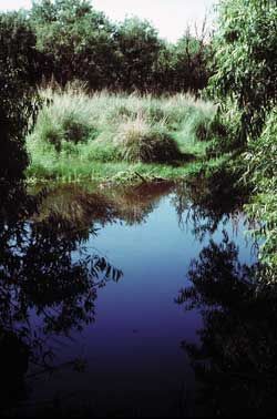
The San Andres National Wildlife Refuge is located in the southern San Andres Mountains of southcentral New Mexico, USA. The refuge, which lies within the northernmost extension of the Chihuahuan Desert, has elevations ranging from 4,200 feet (1,300 m) to 8,239 feet (2,511 m) feet. Refuge habitats vary from creosote and Chihuahuan desert grasslands in the bajadas to pinyon-juniper woodlands at higher elevations. A few springs, seeps, and seasonal streams provide water for wildlife and riparian habitats in the refuge.

<span class="mw-page-title-main">Chihuahuan pocket mouse</span> Species of rodent

The Chihuahuan pocket mouse is a species of heteromyid rodent found in the southwestern United States and Mexico. It was formerly considered a subspecies of the desert pocket mouse, but was determined to be a distinct species in 1996, following analysis of its mitochondrial DNA.

The Reserva Ecológica Municipal Sierra y Cañón de Jimulco is a protected natural area in Torreón, Coahuila, Mexico. Jimulco has a high mountain range of over 10,000 ft, a riparian area formed by the Aguanaval River, an endorrheic basin and an extensive valley with the characteristic flora and fauna of the Chihuahuan Desert. El Cañon del Realito and El Cañon de la Cabeza are two small canyons of great beauty formed by the Aguanaval.

<i>Lycium berlandieri</i> Species of flowering plant

Lycium berlandieri is a species of flowering plant in the nightshade family known by the common name Berlandier's wolfberry. It is native to Mexico and the south-western United States from Arizona to Texas.

<span class="mw-page-title-main">Sierra del Carmen</span>

The Sierra del Carmen, also called the Sierra Maderas del Carmen, is a northern finger of the Sierra Madre Oriental in the state of Coahuila, Mexico. The Sierra begins at the Rio Grande at Big Bend National Park and extends southeast for about 72 kilometres (45 mi), reaching a maximum elevation of 2,720 metres (8,920 ft). Part of the Sierra del Carmen is protected in the Maderas del Carmen Biosphere Reserve as part of a bi-national effort to conserve a large portion of the Chihuahua Desert in Mexico and Texas.

<span class="mw-page-title-main">Cañón de Santa Elena Flora and Fauna Protection Area</span>

The Cañón de Santa Elena Flora and Fauna Protection Area is a protected area for plants and wildlife in the Mexican municipalities of Manuel Benavides and Ojinaga, in the state of Chihuahua. It was founded on November 7, 1994 and has an area of 277,209 hectares.

<span class="mw-page-title-main">Jornada Biosphere Reserve</span>

The Jornada Biosphere Reserve is a UNESCO Biosphere Reserve in southern New Mexico. It is one of three biosphere reserves representing the Chihuahuan Desert. The area extends from the crest of the San Andres Mountains, which are dominated by shrub woodlands, to the Jornada Plains characterized by semi-desert grasslands.

<span class="mw-page-title-main">Oscura Mountains</span>

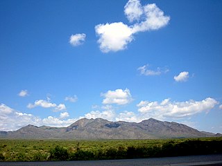
Oscura Mountains, originally known to the Spanish as the Sierra Oscura, are a ridge of mountains, trending north and south, east of the Jornada del Muerto and west of the Tularosa Valley. The word oscura means "dark" and refers to the dark color of the mountains due to the Pinyon-juniper vegetation at their higher elevations. The Oscuras are located in Socorro County and Lincoln County, New Mexico. Their southern end is at 33°30′30″N106°18′45″W and their northern end is at 33°49′15″N106°22′20″W near North Oscura Peak. Their highest elevation is Oscura Peak at 8,625 feet.

References

  1. 1 2 3 4 5 6 7 8 9 10 11 12 13 14 15 16 17 18 19 20 21 22 23 24 25 "The National Map - Advanced Viewer". apps.nationalmap.gov. Retrieved 2021-08-16.
  2. "U.S. Census Bureau QuickFacts: Hudspeth County, Texas". www.census.gov. Retrieved 2021-08-17.
  3. 1 2 3 Whitford, Walt, and Kevin Bixby. The Last Desert Grasslands. Southwest Environmental Center, 2006.
  4. 1 2 "Explore Otero Mesa: The Last Desert Grassland". www.wildmesquite.org. Retrieved 2021-08-16.
  5. Solveig, Turpin; Turpin, Jeff (2013). "Rock Art and Site Distribution in the Cornudas Mountains: A Reconnaissance on University Lands Hudspeth County, Texas". TAS, Inc. via Academia.
  6. Seymour, Deni J. Pasaron Por Aquí, 2012. Prepared for New Mexico Wilderness Alliance and The Wilderness Society.
  7. 1 2 3 "Level III Ecoregions of the Continental United States" (PDF). United States Environmental Protection Agency.
  8. "Primary Distinguishing Characteristics of Level III Ecoregions of the Continental United States". Level III and IV Ecoregions of the Continental United States. United States Environmental Protection Agency. September 2013.
  9. "MRLC Viewer". www.mrlc.gov. Retrieved 2021-08-16.
  10. 1 2 Grover, Herbert D.; Musick, H. Brad (1990-12-01). "Shrubland encroachment in southern New Mexico, U.S.A.: An analysis of desertification processes in the American southwest". Climatic Change. 17 (2): 305–330. Bibcode:1990ClCh...17..305G. doi:10.1007/BF00138373. ISSN   1573-1480. S2CID   153791113.
  11. 1 2 Buffington, Lee C.; Herbel, Carlton H. (1965). "Vegetational Changes on a Semidesert Grassland Range from 1858 to 1963". Ecological Monographs. 35 (2): 140–164. doi:10.2307/1948415. ISSN   0012-9615. JSTOR   1948415.
  12. 1 2 Branscomb, Bruce L. (May 1958). "Shrub Invasion of a Southern New Mexico Desert Grassland Range". Journal of Range Management. 11 (3): 129–132. doi:10.2307/3893715. hdl: 10150/553887 . ISSN   0022-409X. JSTOR   3893715.
  13. 1 2 Brown, Albert L. (July 1950). "Shrub Invasion of Southern Arizona Desert Grassland". Journal of Range Management. 3 (3): 172–177. doi:10.2307/3894118. ISSN   0022-409X. JSTOR   3894118.
  14. 1 2 Bahre, Conrad J.; Shelton, M. L. (September 1993). "Historic Vegetation Change, Mesquite Increases, and Climate in Southeastern Arizona". Journal of Biogeography. 20 (5): 489. doi:10.2307/2845722. ISSN   0305-0270. JSTOR   2845722.
  15. 1 2 Humphrey, Robert R. (April 1958). "The desert grassland a history of vegetational change and an analysis of causes". The Botanical Review. 24 (4): 193–252. doi:10.1007/bf02872568. ISSN   0006-8101. S2CID   21410270.
  16. 1 2 Gibbens, R. P.; Tromble, J. M.; Hennessy, J. T.; Cardenas, M. (March 1983). "Soil Movement in Mesquite Dunelands and Former Grasslands of Southern New Mexico from 1933 to 1980". Journal of Range Management. 36 (2): 145. doi:10.2307/3898148. hdl: 10150/646090 . ISSN   0022-409X. JSTOR   3898148.
  17. 1 2 Hennessy, J. T.; Gibbens, R. P.; Tromble, J. M.; Cardenas, M. (May 1983). "Vegetation Changes from 1935 to 1980 in Mesquite Dunelands and Former Grasslands of Southern New Mexico". Journal of Range Management. 36 (3): 370. doi:10.2307/3898490. hdl: 10150/645947 . ISSN   0022-409X. JSTOR   3898490.
  18. 1 2 Wooton, E.O. (1908). "The range problem in New Mexico". New Mexico Agricultural Experiment Station. Bulletin No. 66.
  19. 1 2 Parker, Kenneth W. (1952). The mesquite problem on southern Arizona ranges (PDF). U.S. Dept. of Agriculture. OCLC   5193888.
  20. 1 2 Bahre, Conrad Joseph (1991). A Legacy of Change : Historic Human Impact on Vegetation in the Arizona Borderlands. University of Arizona Press. ISBN   978-0-8165-3639-9. OCLC   962149316.
  21. 1 2 Leopold, Luna B. (April 1951). "Vegetation of Southwestern Watersheds in the Nineteenth Century". Geographical Review. 41 (2): 295–316. doi:10.2307/211025. ISSN   0016-7428. JSTOR   211025.
  22. CEC and TNC. 2005. North American Central grasslands priority conservation areas: technical report and documentation. Eds. J.W. Karl and J. Hoth. Commission for Environmental Cooperation and The Nature Conservancy. Montreal, Quebec.
  23. World Wildlife Fund et al. 2000. Ecoregion-Based Conservation in the Chihuahuan Desert: A Biological Assessment. Eds. Eric Dinerstein et al. http://awsassets.panda.org/downloads/wwfbinaryitem2757.pdf
  24. 1 2 "ArcGIS Web Application". www.arcgis.com. Retrieved 2021-08-17.
  25. "NMSLO Land Status". mapservice.nmstatelands.org. Retrieved 2021-08-17.
  26. "Programs: Natural Resources: Rangelands and Grazing: Livestock Grazing: McGregor Range Grazing Contracts | Bureau of Land Management". www.blm.gov. Retrieved 2021-08-17.
  27. "McGregor Range | Bureau of Land Management". www.blm.gov. Retrieved 2021-08-17.
  28. "Ecological site descriptions". edit.jornada.nmsu.edu. Retrieved 2021-08-17.
  29. "EDIT". edit.jornada.nmsu.edu. Retrieved 2021-08-17.
  30. 1 2 3 4 "Ecological site R042XB010NM". edit.jornada.nmsu.edu. Retrieved 2021-08-17.
  31. 1 2 "Ecological site R042XD008NM". edit.jornada.nmsu.edu. Retrieved 2021-08-17.
  32. 1 2 "Ecological site R042XD001NM". edit.jornada.nmsu.edu. Retrieved 2021-08-17.
  33. 1 2 "Ecological site R042XB011NM". edit.jornada.nmsu.edu. Retrieved 2021-08-17.
  34. 1 2 "Ecological site R042XB016NM". edit.jornada.nmsu.edu. Retrieved 2021-08-17.
  35. 1 2 "Ecological site R042XB019NM". edit.jornada.nmsu.edu. Retrieved 2021-08-17.
  36. 1 2 "Ecological site R042XB021NM". edit.jornada.nmsu.edu. Retrieved 2021-08-17.
  37. 1 2 "Ecological site R042XC001NM". edit.jornada.nmsu.edu. Retrieved 2021-08-17.
  38. 1 2 "Ecological site R042XC002NM". edit.jornada.nmsu.edu. Retrieved 2021-08-17.
  39. 1 2 "Ecological site R042XC006NM". edit.jornada.nmsu.edu. Retrieved 2021-08-17.
  40. 1 2 "Ecological site R042XC007NM". edit.jornada.nmsu.edu. Retrieved 2021-08-17.
  41. 1 2 "Ecological site R042XC020NM". edit.jornada.nmsu.edu. Retrieved 2021-08-17.
  42. 1 2 "Ecological site R042XC022NM". edit.jornada.nmsu.edu. Retrieved 2021-08-17.
  43. 1 2 "Ecological site R042XC030NM". edit.jornada.nmsu.edu. Retrieved 2021-08-17.
  44. 1 2 "Ecological site R042XC241TX". edit.jornada.nmsu.edu. Retrieved 2021-08-17.
  45. 1 2 "Ecological site R042XC247TX". edit.jornada.nmsu.edu. Retrieved 2021-08-17.
  46. 1 2 "Ecological site R042XC249TX". edit.jornada.nmsu.edu. Retrieved 2021-08-17.
  47. 1 2 "Ecological site R042XC255TX". edit.jornada.nmsu.edu. Retrieved 2021-08-17.
  48. 1 2 "Ecological site R042XD002NM". edit.jornada.nmsu.edu. Retrieved 2021-08-17.
  49. 1 2 "Ecological site R042XD003NM". edit.jornada.nmsu.edu. Retrieved 2021-08-17.
  50. 1 2 "Ecological site R042XD004NM". edit.jornada.nmsu.edu. Retrieved 2021-08-17.
  51. 1 2 "Ecological site R042XD005NM". edit.jornada.nmsu.edu. Retrieved 2021-08-17.
  52. 1 2 "Ecological site R042XC244TX". edit.jornada.nmsu.edu. Retrieved 2021-08-17.
  53. 1 2 "Ecological site R042XD006NM". edit.jornada.nmsu.edu. Retrieved 2021-08-17.
  54. 1 2 "Ecological site R042XD744TX". edit.jornada.nmsu.edu. Retrieved 2021-08-17.
  55. 1 2 "Ecological site R042XE278TX". edit.jornada.nmsu.edu. Retrieved 2021-08-17.
  56. "Macrostrat". Macrostrat.
  57. BLM1990. Resource management plan amendment: McGregor Range, New Mexico. BLM-NM-PT-90-033-4410, U.S. Bur. Land Manage Las Cruces. One Vol. with Parts, various p.
  58. Ludwig, J.A., Muldavin, E., Blanche, K.R. "Vegetation Change and Surface Erosion in Desert Grasslands of Otero Mesa, Southern New Mexico: 1982 to 1995." The American Midland Naturalist, 144(2):273-285. 2000
  59. Stuart, Hans (June 6, 2005). "BLM's Next Oil and Gas Lease Sale to Include Otero Mesa Parcel". Bureau Of Land Management. Archived from the original on 2012-10-08. Retrieved 2014-02-13.