Parker, Colorado

Last updated

Parker, Colorado
Parker, Colorado.JPG
Mainstreet in downtown Parker
Flag of Parker, Colorado.svg
Douglas County Colorado Incorporated and Unincorporated areas Parker Highlighted 0857630.svg
Location of Parker in Douglas County, Colorado
Coordinates: 39°31′10″N104°45′57″W / 39.51944°N 104.76583°W / 39.51944; -104.76583
CountryUnited States
State Colorado
County Douglas
Founded1864
Incorporated May 1, 1981
Named for James Parker
Government
  Type Home rule municipality
   Mayor Jeff Toborg
  Council MembersAnne Barrington, John Diak, Laura Hefta, Todd Hendreks, Joshua Rivero, Brandi Wilks
Area
[1]
   Town 22.455 sq mi (58.158 km2)
  Land22.447 sq mi (58.138 km2)
  Water0.008 sq mi (0.022 km2)
Elevation
[2]
5,870 ft (1,789 m)
Population
 (2020) [3]
   Town 58,512
  Estimate 
(2022) [4]
61,222
  RankUS: 633rd
CO: 19th
  Density406.57/sq mi (1,053.01/km2)
   Urban
2,686,147 (US: 18th)
   Metro
2,985,871 (US: 19th)
   Combined
3,663,515 (US: 18th)
Time zone UTC–7 (Mountain (MST))
  Summer (DST) UTC–6 (MDT)
ZIP Codes [5]
80134, 80138
Area code(s) 303, 720, and 983
FIPS code 08-57630
GNIS feature ID0185051 [2]
Sales tax 8.0% [6]
Website www.parkerco.gov

Parker is a home rule municipality in Douglas County, Colorado, United States. As a self-declared "town" under the home rule statutes, Parker is the second most populous town in the county; Castle Rock is the most populous (the community of Highlands Ranch, with a population of over 100,000, is an unincorporated CDP). [7] In recent years, Parker has become a commuter town at the southeasternmost corner of the Denver metropolitan area. The population was 58,512 at the 2020 census. [3] Parker is now the 19th most populous municipality in the state of Colorado.

Contents

History

Native Americans

The first known people to live in the area were ancient and Plains Woodland peoples. Utes, Arapaho, and Cheyenne were in the area by the 1800s. They were all hunter-gatherers who established seasonal camps to acquire food. [8] A nearby rock shelter, Franktown Cave, shows evidence of habitation beginning in the early Archaic period about 6400 BC and continuing through each of the intervening cultural periods to 1725 AD. [9]

Pine Grove

Stage roads were established on historic Cherokee and Trapper's Trails through present-day Denver. In 1864, Alfred Butters established the Pine Grove Way Station in a small one-room building (south of the current Parker United Methodist Church) to sell provisions, handle mail and messages, and provide respite for travelers. [8] [10] The area was then within the Territory of Colorado (1861–1876). Butters became a state senator and representative. His house is on the National Register of Historic Places listings in downtown Denver. [10] George Long and his wife purchased the building, moved it to its present location on Main Street, and expanded it to include ten rooms, a ball room and outbuildings. [8] Built at the junction of stage routes, it was called Twenty Mile House for its distance to Denver. The stage station offered provisions, meals, and lodging, as well as protection for early settlers against attacks by Native Americans. [8] [11]

Initially, there were peaceful interactions with Native Americans. Chiefs Washington and Colorow led their tribes along Sulphur Gulch, passing and sometimes visiting cabins of early settlers, like John and Elizabeth Tallman. During one visit, Chief Washington offered up to 20 ponies in trade for their red-headed son. They occasionally heard the sounds of celebration and mourning from nearby encampments. [10] Tension between settlers and Native Americans began to build in the 1860s due to broken treaties, aggression, and cultural misunderstanding. People became especially fearful following the Hungate massacre of 1864 in present-day Elbert County, which may have been started by Nathan Hungate shooting a Native American who stole his horse. It may have been a precipitating factor in the Sand Creek massacre led by General John Chivington later that year. John Tallman was one of the first to arrive at the scene of the Hungate Massacre and he served under Chivington during the Sand Creek massacre. The citizens of Parker became quite concerned and closed the school for a brief time after the massacres. In 1870, Jonathan Tallman (John's brother) was killed by Native Americans while out riding his mule. [10]

Twenty Mile House, Parker, Colorado, 1908 Twenty Mile House - Parker, Colorado - 1908.jpg
Twenty Mile House, Parker, Colorado, 1908

In 1869, Twenty Mile House was owned by Nelson and Susan Doud. [8] [11] In 1870, the Douds purchased the Seventeen Mile House in what is now Centennial and sold the Twenty Mile House [12] to James S. Parker, an American Civil War veteran from Illinois who came to Colorado in 1865. [8] [13] He added a blacksmith shop and mercantile store. In December 1870, [8] or 1873, a post office was established for the Pine Grove settlement; James Parker was the postmaster. [14] He built a schoolhouse and provided lodging and the first year's salary for the teacher. [8] George Parker, James' brother, homesteaded and built a saloon on land east of Parker Road. [8] George owned most of the land that ultimately became the town of Parker. He encouraged settlers and business development by "parceling out his spread" to newcomers. [8] [10]

Parker

The name of the settlement was changed to Parker in 1882. [14] [15] It was first called Parkers' for the two brothers and largest landowners, but the apostrophe was later dropped. [10] That year, the Denver and New Orleans Railroad completed the initial railroad route [16] that provided service between Denver, Parker, and Colorado Springs. To ensure that the railroad came through the center of town, rather than along Cherry Creek, James Parker sold his right-of-way for $1 and his brother George sold his right-of-way to bring the railroad into the center of town to Parker station. [17]

Rhode Island Hotel, 1908. Built near the railroad depot, the hotel had modern conveniences, a livery stable, a telephone company for the town, and a telegraph office. Over the years, it has been used for multiple purposes. It is now contained within the 20 Mile Center on Mainstreet. The outline of the old hotel can be seen from the rear of the building. Rhode Island Hotel - Parker, Colorado - 1908.jpg
Rhode Island Hotel, 1908. Built near the railroad depot, the hotel had modern conveniences, a livery stable, a telephone company for the town, and a telegraph office. Over the years, it has been used for multiple purposes. It is now contained within the 20 Mile Center on Mainstreet. The outline of the old hotel can be seen from the rear of the building.

James donated three acres for Parker Cemetery around 1884, at which time it held the graves of his two sons. It holds the graves of early settlers, the earliest known death was in 1870. Parker (died 1910) and his wife Mattie (died 1887) are also buried there. [8] In the mid-1880s, gold was found at Newlin Gulch (site of the current Rueter–Hess Reservoir.) More businesses were added, including a dry goods store, two more general mercantile stores, another blacksmith shop, a livery stable, barber shop, creamery, stockyard, hotel, church, and a brickworks. Many of these were added by 1900. [8] [10] Victorian architectural style houses were built along Pikes Peak Drive in the 1910s. [19] The Parker station of the Colorado and Southern Railway, which was renamed as it expanded its route, closed in 1931. [17]

Pikes Peak Grange (1908), north of Franktown, near the entrance to Hidden Mesa Open Space Pikes Peak Grange.JPG
Pikes Peak Grange (1908), north of Franktown, near the entrance to Hidden Mesa Open Space

At least through the 1930s, there were dances the first Saturday of each month at Pikes Peak Grange, located north of Franktown. The dances were attended by teenagers from Parker and Elizabeth. [20]

The Parker City Land Company began development of a "modern western town" in the 1960s, but they did not complete the housing projects due to financial short-falls. The developer skipped town in 1971. About 1980 or 1981, the development was completed by another builder. Dean Salibury advocated for Parker's incorporation to protect its landowners. [20] The town was incorporated in 1981, [21] and Salisbury was Parker's first mayor. [20] Parker grew exponentially in the mid-1990s and mid-2000s, during the growth of Denver's southern suburbs. [21] In 1981 there were 285 people in Parker and by 2014 48,000 people resided in the town. [19]

Historic places

Ruth Memorial Methodist Episcopal Church, listed on the National Register of Historic Places Ruth memorial methodist episcopal church.jpg
Ruth Memorial Methodist Episcopal Church, listed on the National Register of Historic Places

The Twenty Mile post office, originally the Pine Grove post office building, was restored by the Parker Area Historical Society. It is located on Mainstreet, just west of Parker Road. [22] Ruth Memorial Methodist Episcopal Church is listed on the National Register of Historic Places. [23] The town of Parker was given a grant by the History Colorado State Historical Fund a restoration project for the Parker Consolidated School at the Mainstreet Center. [24] The Hood House, one of two houses that did not sustain any damage during the flood of Tallman Gulch in 1912, is located in Preservation Park. [25] Some of the other historic sites include Tallman–Newlin Cabin and Parker Cemetery. [19]

Geography

Parker is located in northeastern Douglas County. [26] Its northernmost border follows the Arapahoe County line, and the city of Aurora touches the town's northeast border. The center of Parker is 23 miles (37 km) southeast of downtown Denver. [27] Castle Rock, the Douglas County seat, is 15 miles (24 km) to the southwest. Unincorporated communities that border Parker are Dove Valley to the northwest, Stonegate to the west, and The Pinery to the south. [28] Parker sits at an elevation of 5,900 feet above sea level.

According to the United States Census Bureau, the town has a total area of 22.455 square miles (58.158 km2), of which 0.00 square miles (0.008 km2), or 0.02%, is water. [1] Cherry Creek flows through Parker on its way north toward Denver. [29]

Climate

This climate type is usually found in the outskirts of true deserts in low-latitude, semi-arid regions. It has cooler, wetter weather resulting from the higher latitude and mid-latitude frontal cyclone activity. Annual precipitation totals are greater than in tropical and subtropical desert climates. Yearly variations in amount are not as extreme as in the true deserts but are nevertheless large. The Köppen Climate Classification subtype for this climate is "BSk". (mid latitude Steppe Climate).

Climate data for Parker, Colorado
MonthJanFebMarAprMayJunJulAugSepOctNovDecYear
Mean daily maximum °F (°C)43
(6)
46
(8)
51
(11)
60
(16)
69
(21)
80
(27)
86
(30)
84
(29)
77
(25)
66
(19)
52
(11)
45
(7)
63
(18)
Mean daily minimum °F (°C)15
(−9)
18
(−8)
23
(−5)
31
(−1)
40
(4)
49
(9)
55
(13)
54
(12)
46
(8)
35
(2)
23
(−5)
17
(−8)
34
(1)
Average precipitation inches (mm)0.3
(7.6)
0.3
(7.6)
0.9
(23)
1.3
(33)
2.5
(64)
1.9
(48)
2.2
(56)
1.9
(48)
1.1
(28)
0.8
(20)
0.7
(18)
0.3
(7.6)
14.1
(360)
Source: Weatherbase [30]

Demographics

Historical population
CensusPop.Note
1980 290
1990 5,4501,779.3%
2000 23,558332.3%
2010 45,29792.3%
2020 58,51229.2%
2022 (est.)61,222 [4] 4.6%
U.S. Decennial Census [31]
2020 Census [3]

2022 estimate

As of the American Community Survey of 2022, there were 61,222 people, 20,083 households, and 6,525 families residing in the town. The population density was 2,619.7 inhabitants per square mile (1,011.5/km2). There were housing units at an average density of 897.8 per square mile (346.6/km2). The racial makeup of the town was 84.4% White, 4.9% Asian, 0.4% Native American, 0.03% Pacific Islander, 1.88% from other races, 1.01% Black, and 6.6% from two or more races. Hispanic or Latino of any race were 12.1% of the population.

There were 20,083 households, out of which 45.0% had children under the age of 18 living with them, 64.1% were married couples living together, 18.1% had a female householder with no husband present, and 17.7% were non-families. 18.2% of all households were made up of people living alone, and 4.8% had someone living alone who was 65 years of age or older. The average household size was 2.85 and the average family size was 3.28.

In the town, the age of the population is trending older, with 28.3% under the age of 18, 8.8% from 18 to 24, 28.7% from 25 to 44, 25.1% from 45 to 64, and 9.1% who were 65 years of age or older. The median age was 31 years. For every 100 females, there were 97.7 males. For every 100 females age 18 and over, there were 98.2 males.

The median income for a household in the town was $120,075, and the median income for a family was $136,520. Males had a median income of $93,090 versus $63,008 for females. The per capita income for the town was $48,857. About 1.8% of families and 3.0% of the population were below the poverty line, including 1.9% of those under age 18 and 1.3% of those age 65 or over.

2010 census

As of the 2010 census, there were 45297 people, _ households, and _ families residing in the town.

2000 census

As of the 2000 census, there were 23,558 people, 7,929 households, and 6,525 families residing in the town. The population density was 1,615.2 people per square mile (623.4/km²). There were 8,352 housing units at an average density of 572.6 per square mile (221.0/km²). The racial makeup of the town was 92.60% White, 1.71% Asian, 1.01% African American, 0.45% Native American, 0.03% Pacific Islander, 1.88% from other races, and 2.33% from two or more races. Hispanic or Latino of any race were 5.80% of the population.

There were 7,929 households out of which 52.5% had children under the age of 18 living with them, 71.8% were married couples living together, 8.0% had a female householder with no husband present, and 17.7% were non-families. 13.0% of all households were made up of individuals and 1.4% had someone living alone who was 65 years of age or older. The average household size was 2.96 and the average family size was 3.27.

In the town the population was spread out with 34.0% under the age of 18, 4.9% from 18 to 24, 43.4% from 25 to 44, 15.0% from 45 to 64, and 2.7% who were 65 years of age or older. The median age was 31 years. For every 100 females there were 98.0 males. For every 100 females age 18 and over, there were 94.3 males.

The median income for a household in the town was $74,116, and the median income for a family was $77,384. Males had a median income of $52,070 versus $35,700 for females. The per capita income for the town was $27,479. About 1.7% of families and 2.3% of the population were below the poverty line, including 2.2% of those under age 18 and 2.1% of those age 65 or over.

Education

Parker is served by Douglas County School District. Douglas County School District has among the highest level of students in Colorado. Students have scored, on average, 12 to 19 percent above the state average. [32] The district was rated 9th in the state in 2009. [33] The Pine Lane Elementary School had the largest student enrollment in Parker until Mammoth Heights Elementary opened in January 2007 and took the overload.

Two of the three principal high schools in the area, Ponderosa and Chaparral High School, have a cross-town rivalry and compete annually for The Pride of Parker trophy. Legend High School opened in 2008, as Douglas County's ninth high school.

Private schools in Parker include:

For other Parker and Douglas County school information:

Parker Secondary Schools:

Parker also has six public charter schools:

College classes:

Post-Secondary Education:

Recreation

The Town maintains 10 trails with over 27 miles of concrete paved, multi-use trails, over 6 miles of natural surface equestrian trails and a 1.8-mile natural surface, multi-use loop trail. The Cherry Creek Trail runs along Cherry Creek, north and south through Parker. Bicycling, hiking, nature walks, and cross-country skiing are all popular uses.

The Rueter–Hess Reservoir is located west of town and is not yet open for recreational use of the water as of 2021, although trails around the reservoir are open. Planned activities there include fishing, hiking, and non-motorized boating. [34] No natural streams flow into the reservoir, instead, water rights owned by the Parker Water and Sanitation District provide water delivered via Cherry Creek and local canals. If filled to capacity, the surface size would be 1,140 acres.

The Parker Recreation Center is located alongside Lincoln Avenue and has several amenities such as gyms, swimming pools, fitness and cycling studios, sports and fitness classes, and more.

The Parker Field House offers 100,000 square feet (9,300 m2) of space, including sports turf, batting cages, gymnasiums, inline rink with Sport Court flooring, and climbing.

The Parker Racquet Club opened in 2019 and offers six indoor courts to tennis and pickleball enthusiasts. Phase 2, opening in 2023, adds one of the first paddle courts in Colorado, and additional outdoor tennis courts and pickleball courts.

Attractions

The town currently maintains about 250 acres of developed parkland and more than 900 acres of open space. [35]

Parker is home to the Parker Arts, Culture, & Events Center (PACE). It is a venue that hosts art exhibits, art classes, theater productions, and concerts. It is the official home of the Parker Symphony Orchestra, a community orchestra established in 1994, that offers a full season of orchestra concerts annually. The Parker Symphony was formerly the South Suburban Community Orchestra.

Parker is also home to Colorado School of Dance, which partners with PACE each December to produce the "Nutcracker of Parker." The annual ballet has been a Parker tradition since 2003.

Local media

Parker currently has one local magazine and one local paper. Search Parker Magazine is the local magazine and the Parker Chronicle is the local paper. Parker also receives the county-wide channel, Douglas County 8, which broadcasts school sports events and assorted programs run by residents. [36]

Notable people

Notable individuals who were born in or have lived in Parker include:

See also

Related Research Articles

<span class="mw-page-title-main">Douglas County, Colorado</span> County in Colorado, United States

Douglas County is a county located in the U.S. state of Colorado. As of the 2020 Census, the population was 357,978. The county is named in honor of U.S. Senator Stephen A. Douglas. The county seat is Castle Rock.

<span class="mw-page-title-main">Castle Rock, Colorado</span> Town in Colorado, United States

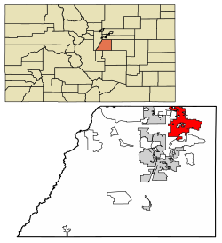
Castle Rock is a home rule town that is the county seat and the most populous municipality of Douglas County, Colorado, United States. The town population was 73,158 at the 2020 census, a 51.68% increase since the 2010 census. Castle Rock is the most populous Colorado town and the 16th most populous Colorado municipality. Castle Rock is a part of the Denver-Aurora-Lakewood, CO Metropolitan Statistical Area and the Front Range urban corridor.

<span class="mw-page-title-main">Summit County, Colorado</span> County in Colorado, United States

Summit County is a county located in the U.S. state of Colorado. As of the 2020 census, the population was 31,055. The county seat and largest town is Breckenridge.

<span class="mw-page-title-main">Cheyenne County, Colorado</span> County in Colorado, United States

Cheyenne County is a county located in the U.S. state of Colorado. The county population was 1,748 at 2020 census. The county seat is Cheyenne Wells.

<span class="mw-page-title-main">Arapahoe County, Colorado</span> County in Colorado, United States

Arapahoe County is a county located in the U.S. state of Colorado. As of the 2020 census, its population was 655,070, making it the third-most populous county in Colorado. The county seat is Littleton, and the most populous city is Aurora. The county was named for the Arapaho Native American tribe, who once lived in the region.

<span class="mw-page-title-main">Broomfield, Colorado</span> Consolidated city and county in Colorado, United States

Broomfield is a consolidated city and county located in the U.S. state of Colorado. It has a consolidated government which operates under Article XX, Sections 10–13 of the Constitution of the State of Colorado. Broomfield's population was 74,112 at the 2020 United States Census, making it the 15th most populous municipality and the 12th most populous county in Colorado. Broomfield is a part of the Denver–Aurora–Lakewood, CO Metropolitan Statistical Area and the Front Range urban corridor.

<span class="mw-page-title-main">Sherrelwood, Colorado</span> Place in Colorado, United States

Sherrelwood is an unincorporated community and a census-designated place (CDP) located in and governed by Adams County, Colorado, United States. The CDP is a part of the Denver–Aurora–Lakewood, CO Metropolitan Statistical Area. The population was 19,228 at the 2020 census.

<span class="mw-page-title-main">Thornton, Colorado</span> City in Colorado, United States

Thornton is a home rule municipality located in Adams and Weld counties, Colorado, United States. The city population was 141,867, all in Adams County, at the 2020 United States Census, an increase of +19.44% since the 2010 United States Census. Thornton is the sixth most populous city in Colorado and the 191st most populous city in the United States. Thornton is 10 miles (16 km) north of the Colorado State Capitol in Denver and is a part of the Denver–Aurora–Lakewood, CO Metropolitan Statistical Area.

<span class="mw-page-title-main">Cherry Hills Village, Colorado</span> City in Colorado, United States

The City of Cherry Hills Village is a home rule municipality located in Arapahoe County, Colorado, United States. The city population was 6,442 at the 2020 United States Census. Cherry Hills Village is a part of the Denver–Aurora–Lakewood, CO Metropolitan Statistical Area and the Front Range Urban Corridor.

<span class="mw-page-title-main">Deer Trail, Colorado</span> Town in Colorado, United States

The Town of Deer Trail is a Statutory Town located in eastern Arapahoe County, Colorado, United States. The town population was 1,068 at the 2020 United States Census, a +95.60% increase since the 2010 United States Census. Deer Trail is a part of the Denver–Aurora–Lakewood, CO Metropolitan Statistical Area and the Front Range Urban Corridor. The town is situated along Interstate 70, approximately 55 miles (89 km) east of Denver.

<span class="mw-page-title-main">Castle Pines, Colorado</span> City in Colorado, United States

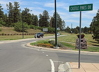
The City of Castle Pines is a home rule municipality located in Douglas County, Colorado, United States. The city population was 11,036 at the 2020 United States Census. Castle Pines is a part of the Denver–Aurora–Lakewood, CO Metropolitan Statistical Area and the Front Range Urban Corridor. The city is located north of the Town of Castle Rock and south of the City of Lone Tree, Colorado.

<span class="mw-page-title-main">Highlands Ranch, Colorado</span> Census Designated Place in Colorado, United States

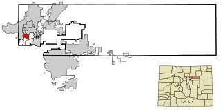
Highlands Ranch is an unincorporated community and a census-designated place (CDP) located in and governed by Douglas County, Colorado, United States. The CDP is a part of the Denver–Aurora–Lakewood, CO Metropolitan Statistical Area. The population of the Highlands Ranch CDP was 105,631 at the 2020 census, making it the most populous unincorporated community in the State of Colorado. The Highlands Ranch Metropolitan District provides services to the community, which lies in ZIP Codes 80126, 80129, 80130, and 80163.

<span class="mw-page-title-main">Rifle, Colorado</span> City in Colorado, United States

Rifle is a home rule municipality in, and the most populous community of, Garfield County, Colorado, United States. The population was 10,437 at the 2020 census. Rifle is a regional center of the cattle ranching industry located along Interstate 70 and the Colorado River just east of the Roan Plateau, which dominates the western skyline of the town. The town was founded in 1882 by Abram Maxfield, and was incorporated in 1905 along Rifle Creek, near its mouth on the Colorado. The community takes its name from the creek.

<span class="mw-page-title-main">Cortez, Colorado</span> City in Colorado, United States

Cortez is a home rule municipality that is the county seat and the most populous municipality of Montezuma County, Colorado, United States. The city population was 8,766 at the 2020 United States Census.

<span class="mw-page-title-main">Fort Morgan, Colorado</span> City in Colorado, United States

Fort Morgan is the home rule municipality city that is the county seat and the most populous municipality of Morgan County, Colorado, United States. The city population was 11,597 at the 2020 United States Census. Fort Morgan is the principal city of the Fort Morgan, CO Micropolitan Statistical Area.

<span class="mw-page-title-main">Evans, Colorado</span> City in Colorado, United States

The City of Evans is a home rule municipality located in Weld County, Colorado, United States. The city population was 22,165 at the 2020 United States Census, a 19.57% increase since the 2010 United States Census. Evans is a part of the Greeley, CO Metropolitan Statistical Area and the Front Range Urban Corridor.

<span class="mw-page-title-main">Firestone, Colorado</span> Town in Colorado, United States

The Town of Firestone is a Statutory Town in southwestern Weld County, Colorado, United States. The town population was 16,381 at the 2020 United States Census, a 61.44% increase since the 2010 United States Census. Firestone is a part of the Greeley, CO Metropolitan Statistical Area and the Front Range Urban Corridor.

<span class="mw-page-title-main">Fort Lupton, Colorado</span> City in Colorado, United States

The City of Fort Lupton is a Statutory City located in southern Weld County, Colorado, United States. The town population was 7,955 at the 2020 United States Census. Fort Lupton is a part of the Greeley, Colorado Metropolitan Statistical Area and the Front Range Urban Corridor.

<span class="mw-page-title-main">Castle Pines Village, Colorado</span> Census Designated Place in Colorado, United States

Castle Pines Village, also known as The Village at Castle Pines or The Village, is an unincorporated community and a census-designated place (CDP) located in and governed by Douglas County, Colorado, United States. The CDP is a part of the Denver–Aurora–Lakewood, CO Metropolitan Statistical Area. The population of the Castle Pines Village CDP was 4,327 at the United States Census 2020. Douglas County governs the unincorporated community and the Castle Pines Metropolitan District provides services. The Castle Rock post office serves the area.

<span class="mw-page-title-main">John and Elizabeth Tallman</span> Early settlers of Colorado in 1866

John and Elizabeth Tallman settled in Pine Grove of Colorado Territory, present-day Parker, Colorado, in 1866. They were among the early settlers in Douglas County, Colorado, with John working as a cattle rancher, sawmill hand, county clerk, and businessman. John and Elizabeth ran the Elizabeth Hotel in the late 1890s. She also wrote of her experiences with Native Americans and observations of warfare among the Cheyenne, Arapaho, and the Utes.

References

  1. 1 2 "2023 U.S. Gazetteer Files". Census.gov . United States Census Bureau. Retrieved July 24, 2022.
  2. 1 2 U.S. Geological Survey Geographic Names Information System: Parker, Colorado
  3. 1 2 3 "Explore Census Data". United States Census Bureau . Retrieved February 9, 2024.
  4. 1 2 "City and Town Population Totals: 2020-2022". United States Census Bureau. February 9, 2024. Retrieved February 9, 2024.
  5. "ZIP Code Lookup" (JavaScript/HTML). USPS.com. United States Postal Service . Retrieved February 9, 2024.
  6. "Parker (CO) sales tax rate" . Retrieved February 9, 2024.
  7. "U.S. Census website". United States Census Bureau . Retrieved June 26, 2018.
  8. 1 2 3 4 5 6 7 8 9 10 11 12 "A Brief History of Parker, Colorado". Parker Area Historical Society, Parker Colorado. Retrieved June 26, 2018.
  9. Gilmore, Kevin P. (April 24, 2012). "National Register Nomination Form: Franktown Cave. Site 5DA272". University of Denver. pp. 1–2, 4. Archived from the original on April 24, 2012.
  10. 1 2 3 4 5 6 7 Michlewicz, Chris (December 11, 2014). "Echoes of Parker's Past - The Early Years: 1864-1910". Parker Chronicle. Retrieved June 26, 2018.
  11. 1 2 "Tales Told with Markers" (PDF). Colorado Magazine. Summer 1970. p. 223. Archived from the original (PDF) on June 12, 2018. Retrieved June 25, 2018.
  12. "17 Mile Farm Park Master Plan". Arapahoe County Government. October 2007. p. 16. Retrieved June 26, 2018.
  13. Bishop, Will C. (1911). The Trail: A Magazine "for Colorado.". W.C. Bishop. p. 27.
  14. 1 2 Bright, William (2004). Colorado Place Names. Big Earth Publishing. p. 135. ISBN   978-1-55566-333-9.
  15. Donald R. Elliott (1999). Doris L. Elliott (ed.). "Colorado Place Names" (PDF). Denver Public Library. p. 464. Retrieved June 25, 2018.
  16. Bulletin of the United States Geological Survey. United States Geological Survey. 1910. p.  339.
  17. 1 2 Sandra Jane Whelchel (2015). Parker. Arcadia Publishing. pp. 7–8. ISBN   978-1-4671-3315-9.
  18. Smith, Larry T. "Rhode Island Hotel". Parker Area Historical Society - Parker Colorado. Retrieved June 26, 2018.
  19. 1 2 3 Michlewicz, Chris (December 11, 2014). "Echoes of Parker's Past - The Changes: 1995-2014". Parker Chronicle. Retrieved June 26, 2018.
  20. 1 2 3 Michlewicz, Chris (December 11, 2014). "Echoes of Parker's Past - The Simple Life: 1911-1994". Parker Chronicle. Retrieved June 26, 2018.
  21. 1 2 Michlewicz, Chris (December 11, 2014). "Echoes of Parker's Past - Looking Back". Parker Chronicle. Retrieved June 26, 2018.
  22. "Twenty Mile House". Parker Area Historical Society - Parker Colorado. Retrieved June 26, 2018.
  23. "National Register of Historical Places - Colorado, Douglas County". www.nationalregisterofhistoricplaces.com. Retrieved June 26, 2018.
  24. "Parker Consolidated School at the Mainstreet Center". History Colorado. Retrieved June 26, 2018.
  25. Smith, Larry T. (January 2009). "The Hood House". Parker Area Historical Society - Parker Colorado. Retrieved June 26, 2018.
  26. "US Gazetteer files: 2010, 2000, and 1990". United States Census Bureau. February 12, 2011. Retrieved April 23, 2011.
  27. Google Maps, accessed October 16, 2014
  28. "About Parker | Town of Parker - Official Website". www.parkerco.gov. Retrieved May 6, 2024.
  29. U.S. Geological Survey topographic map series, retrieved October 16, 2015
  30. "Weatherbase.com". Weatherbase. 2013. Retrieved on May 5, 2013.
  31. "Census of Population and Housing". census.gov. Retrieved June 4, 2015.
  32. "2009-2010 Quick Facts" (PDF). www.dcsdk12.org. Archived from the original (PDF) on May 16, 2011. Retrieved January 29, 2011.
  33. "Colorado District Rankings". www.schooldigger.com. Retrieved January 29, 2011.
  34. "Rueter-Hess RESERVOIR is NOT Open to the Public Yet..." Rueter-Hess Recreation Authority. July 31, 2019. Archived from the original on September 27, 2021. Retrieved September 27, 2021.
  35. "Parker Parks & Trails".
  36. "The Network Douglas County Television, Colorado". www.douglas.co.us. Archived from the original on January 11, 2011. Retrieved January 29, 2011.
  37. "Josh Adams". University of Wyoming. Archived from the original on April 23, 2016. Retrieved May 3, 2016.
  38. Helling, Steve (August 25, 2015). "Aurora Shooting Prosecutor George Brauchler: The James Holmes Trial 'Will Always Stay with Me'". people.com. Retrieved June 26, 2018.
  39. Meachum, Brandon (July 12, 2006). "Parker player shines in Wimbledon spotlight". The Denver Post. Retrieved May 3, 2016.
  40. "Scott Elrod Biography". IMDb. Retrieved May 3, 2016.
  41. Lynskey, Dorian (March 2, 2013). "John Grant: 'I wanted to let some of the anger out'". The Guardian. Retrieved May 3, 2016.
  42. Michlewicz, Chris (February 26, 2012). "Parker seeks to boost daytime economy". Parker Chronicle. Retrieved May 3, 2016.
  43. Strode, Dale (July 15, 2012). "He's no 'pacer'". The Durango Herald. Archived from the original on June 2, 2016. Retrieved May 3, 2016.
  44. "#486 John Malone". Forbes. 2006. Archived from the original on June 4, 2016. Retrieved May 3, 2016.
  45. "Chris Martinez". Major League Soccer. Retrieved May 3, 2016.
  46. Sanchez, Robert (January 2010). "Dana Inc". 5280. Retrieved May 3, 2016.
  47. Baines, Gary (July 21, 2011). "Soule leading at Colorado Open". Daily Camera. Retrieved May 3, 2016.
  48. Bunch, Joey (October 29, 2015). "Coloradans analyze Wednesday's Republican debate in Boulder". The Denver Post. Archived from the original on October 30, 2015. Retrieved May 3, 2016.
  49. Roberts, Michael (July 8, 2014). "Photos: Tour ex-Dollar Store CEO's astonishing Parker home -- yours for about $18 million". Westword. Retrieved May 3, 2016.
  50. "Derrick White". ESPN. Retrieved August 28, 2018.
  51. "Legend shortstop Bobby Dalbec commits to Arizona baseball". The Denver Post. Retrieved June 29, 2016.
  52. "Chad Muma Draft and Combine Prospect Profile". NFL.com. Retrieved May 4, 2022.

Further reading